On the second floor of the main visitors building within the New York Zoo at Thompson Park in Watertown, New York are the offices of the Tug Hill Tomorrow Land Trust (THTLT). The Trust is a regional, private, nonprofit organization founded in 1990 by a group of Tug Hill residents, and incorporated as an independent, nonprofit organization. Since 1991, the Trust has permanently conserved more than 15,000 acres, and worked with over 86 landowners in Jefferson, Lewis, Oneida, Herkimer, St. Lawrence and Oswego Counties. The conserved land includes working farms, productive forestland, recreation and wild lands – all conserved through voluntary, private land protection. The Trust works collaboratively with many local and statewide conservation organizations – including Ducks Unlimited, Nature Conservancy, Wildlife Conservation Society, among others – to make conservation projects happen. THTLT is one of dozens of other statewide Land Trusts associated with the Land Trust Alliance and is an accredited land trust through the National Land Trust Accreditation Commission.
Over the past decade, Land Trusts nationally have become significant users of GIS technology supporting a wide range of day-to-day business needs including maintaining property databases, generating service areas, project maps or proposed acquisitions. Land Trusts also use GIS for public education and marketing efforts, stewardship and easement monitoring, conservation planning, and increasingly in the online web mapping applications. Land Trust GIS is a web site designed to assist Land Trusts in the use and best practices of GIS technology. Several software and hardware vendors, including both Google and ESRI, offer generous grant opportunities for Land Trusts.
Championing THTLT’s GIS efforts is Richard (Dick) Johnston who started with the organization in May 2012 as their Land Protection Manager. Prior to his time with THTLT, Dick worked with the Idaho Department of Lands, Potlatch Corporation, and as an independent forestry consultant – having used GIS in some capacity in all of his previous jobs. His GIS skills developed over the years through formalized training courses, self-taught tutorials, and on-the-job experience. He started with ArcView 3.0 and has sense migrated to the ArcGIS desktop client. He also uses free download ArcGIS extensions DNR Garmin and ETGeoWizards.
GIS at the THTLT
Dick creates GIS maps for a range of uses such as (1) project partners in preparation of land protection projects to portray the project area, (2) landowners who are cooperating in donating or selling conservation easements, (3) county planners who work with agricultural districting and protected lands, (4) as evidence of baseline conditions for easement properties (some of which are filed with each easement in the counties’ registrar of deeds), (5) conservation organizations/agencies in developing broader landscape level land protection plans, and (6) project grant providers in the grant application review process. The Trust also uses maps in many outreach events to show constituents ongoing work and progress in land protection, fund raising, and to educate the public. Maps are also generated for designated THTLT “fee” lands for recreational use of the properties.
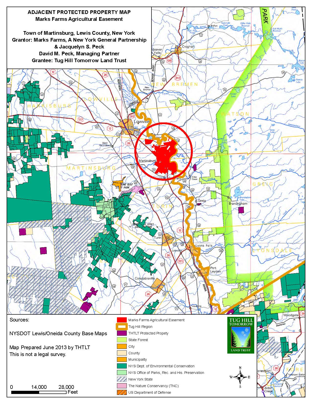
Regional Map of Marks Farms Agricultural Easement, Lewis County, New York
Dick’s GIS work includes creating THTLT datasets with field data collection equipment such as Trimble GPS and ArcPad. He also digitizes off orthoimagery to develop more accurate stream and wetlands layers and to create infrastructure layers of THTLT easement properties. All of THTLT easements require photo documentation and written documentation to establish baselines and to support ongoing monitoring for easement compliance.
Many THTLT GIS efforts start with obtaining local parcel datasets often from county and local assessor offices in which they operate. “Tug Hill Commission has been vital in helping us get that data from time to time, as well as other data, and we often share data with them” says Dick. “I routinely access the NYSDEC Environmental Resource Mapper for information on plant and animal species and natural communities within our project areas, the NRCS Soil Survey for soils data, NYS GIS Clearinghouse, the USDA Farm Service Agency NAIP website for orthoimagery, and the Cornell University Geospatial Information Repository (CUGIR) website to obtain data for streams, wetlands, roads and topography. When available, the Trust also incorporates CAD files and/or property survey plats when it is possible to increase the accuracy of property lines or related survey documentation. Dick notes he also uses data from NYS Agriculture & Markets, NYS Natural Heritage Program, U.S. Fish and Wildlife Service, and the U.S. Army at Fort Drum. As one can see from the maps presented above, Dick has fine – tuned his GIS mapping skills over the past several years and has become quite a cartographer.
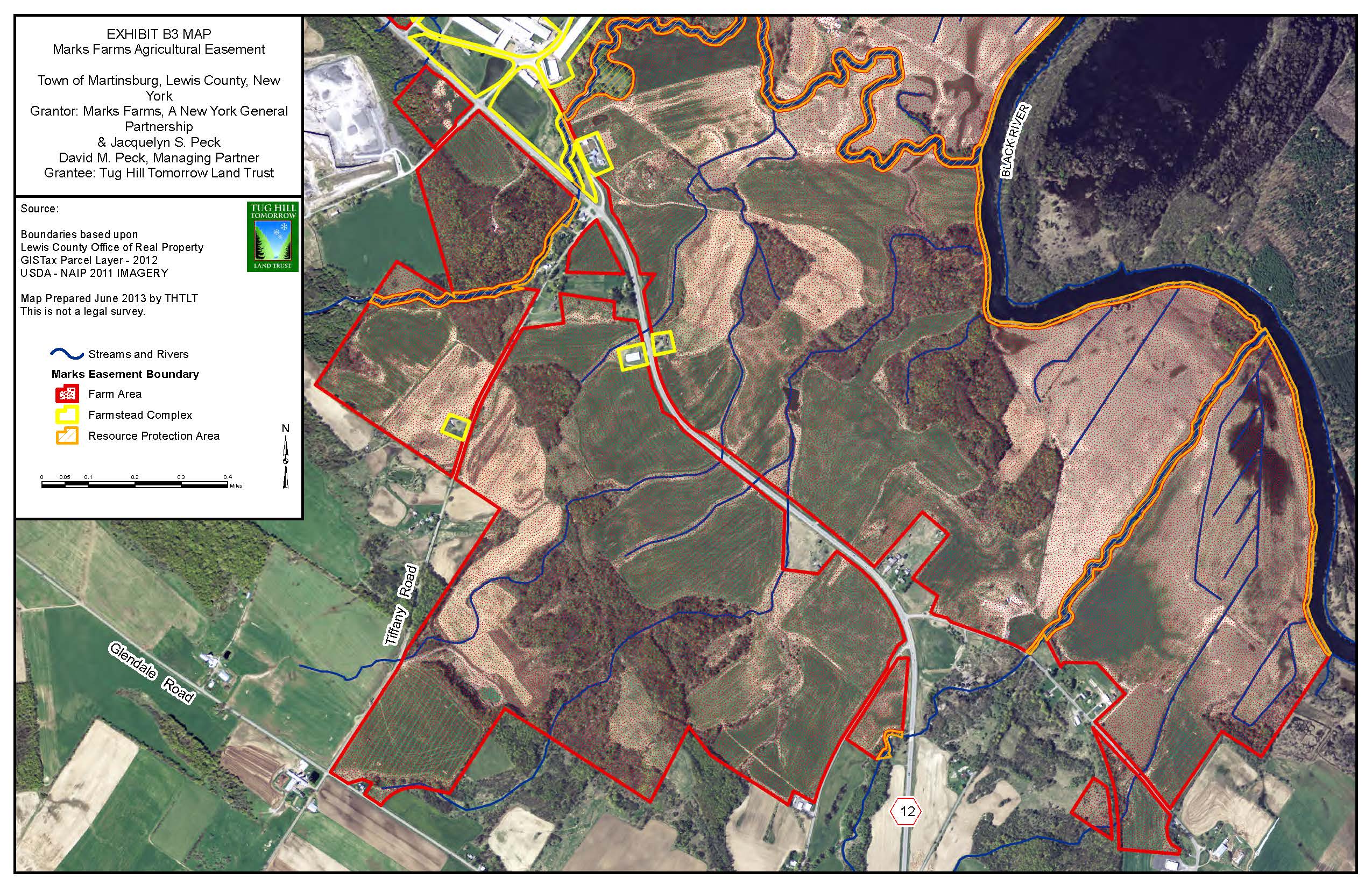
THTLT leverages datasets from County offices of Real Property Services to produce detailed easement boundary maps.
When asked whether or not “GIS” has finally become accepted and resonates amongst local land owners and organizations in the Land Trust space, Johnston emphatically answers “yes”. He continues:
“THTLT utilizes GIS on a daily basis and has become an integral part of our business. Most of the mid and large size land trusts now seem to have full-time dedicated positions to geospatial technology. Even most of the smaller land trusts have at least part-time positions, or volunteers, or independent consultants who provide geospatial support services. Geospatial technology is nearly as common and as essential as the phone”.
THTLT Executive Director Linda Garrett echoes Dick’s sentiments about the importance of GIS at THTLT:
“Having GIS capability is integral to our day to day work on a lot of different levels. We use it not only to help document the conservation values of individual easement projects, but also to prioritize projects and to strategically select specific projects. Before Dick joined our staff we relied on staff from the NYS Tug Hill Commission to produce maps for us. Obviously this had its limitations. Now we can quickly pull up maps and different layers to evaluate projects. I cannot imagine having to go back to the days without this capacity. It would definitely reduce our ability to protect land. Dick brings a high level of technical expertise and professionalism that definitely improved the quality of work for Tug Hill Tomorrow. We do a lot of projects with partners, and his GIS abilities have definitely been an asset to THTLT, and allow us to be a leader on these partnership projects”.
Similar to other conservation organizations of comparable size and purpose across the Empire State, Dick has limited opportunities to attend state or regional GIS conferences or to participate in formal GIS training programs. Nonetheless, he remains committed in leveraging and building GIS throughout the many Trust programs. And the result of his hard work is very visible in the many THTLT mapping products and services produced today.
Unless by chance you stop by the back offices of the THTLT Watertown Thompson Park office, most of us in the statewide GIS community probably won’t ever meet Dick. If you do stop in their offices most likely he’ll be working the GIS desktop. Maybe some heads-up digitizing or configuring that new “user-friendly” ArcGIS Desktop extension. Making maps. Or you could run into him somewhere driving the back roads of Jefferson and Lewis Counties. Collecting data in the field with a GPS unit. Checking a tax map or looking at an easement line.
At the end of the day, Dick Johnston and others supporting GIS activities in Land Trusts across New York State. Big GIS in another small place. Sounds familiar along the Blue Highways of GIS.
Thanks for reading and see you down the road.