Concurrent with the growth of user-friendly and often free online mapping programs, so have the “community” based mapping and planning projects. While earlier generations of geospatial programs focused, and continue to do so on many levels, on mapping the physical world, a new generation of GIS programs and initiatives increasingly focus on the mapping and inventorying of health and human services programs which support a wide range of societal issues and needs. Community mapping programs run the spectrum from being volunteer crowded-sourced to those with full-time, permanent staff with many being aligned with nonprofits, schools, youth and religious groups, and university-based efforts. Seen in a larger context, community mapping projects are often critical components of important global environmental and humanitarian initiatives (Haiti earthquake, Ebola epidemic, CrisisCommons, others).
The Google Maps (New York Community Mapping Projects) Gallery provides numerous examples of statewide community mapping projects. More specific examples include SolidaryNYC which is a program highlighting community supported agriculture (CSA) locations, health care systems, and advocacy organizations while GrowNYC provides community resources mapping in the areas of recycling, education, green markets, and noise pollution, and HabitatMap, a non-profit environmental health justice organization raising awareness about the impact the environment has on human health. And of course there is the uber, long standing OasisNYC initiative which includes online access to data on community-wide food systems, environmental stewardship groups, community gardens, and subsidized housing locations. Here in Westchester County, County GIS staff has worked closely with the Food Bank of Westchester mapping the locations of food pantries across the County. In nearby New Jersey, the Center for Community Mapping supports community mapping efforts for children (GIS4Kids), healthy lifestyles, and plant/wildlife habitat inventories.
Syracuse Community Geography (SCG)
One of the best examples of community oriented mapping is a small, yet impressive and established project, associated with the Syracuse University Geography Department. Started over a decade ago, the Syracuse Community Geography (SCG) program has its origin as part of a Syracuse University project with the Samaritan Center in downtown Syracuse. The initial undertaking, called the Syracuse Hunger Project, was an effort to begin dialogue among the city’s emergency food service providers and other community administrators. At the time, it was felt service providers were operating in isolation and that they collectively had little knowledge of the “big picture” of hunger in the Syracuse area. Because SCG had not yet been formalized, students from an introductory GIS class mapped families living in poverty, social service program recipients, food pantries, soup kitchens, youth and elderly food support program locations, and analyzed patterns to shed light on the geography of need and emergency food provision.
When the analysis was complete the Syracuse Hunger Project hosted a town hall style gathering to publicly announce the results and recommendations. Service providers, community residents, activists, academics, and the media attended. In addition, a final report was issued in April 2004 by the Syracuse Hunger Project. Among the many recommendations issued was one that encouraged the SU Geography Department to create a permanent initiative to provide GIS mapping assistance to community-based organizations that could benefit from geographic analysis of a broad spectrum of community issues. Soon thereafter, a core working group of Geography Department faculty, Syracuse Hunger Project participants, and a local charitable organization created a Community Geographer staff position at Syracuse University. In 2005, Jonnell Allen Robinson was hired as the first Community Geographer. Prior to accepting the position as Community Geography, Ms. Robinson has recently obtained her Master of Public Health in Maternal and Child Health/Global Health at the University of North Carolina-Chapel Hill (2003) and later her PhD (2010) in Geography, specializing in Medical Geography, also from the University of North Carolina-Chapel Hill. In 2012, she was promoted to Assistant Professor of Geography at Syracuse University.
Over ten years later, SCG boasts an impressive portfolio of projects covering a wide range of community and societal issues in the greater Syracuse and central New York region. In 2014 alone, the program continues work on over a dozen projects including “A Geographic Analysis of Tobacco Advertising in Oneida, Madison, and Herkimer Counties, New York” and a statewide analysis of families using the Central New York Ronald McDonald House. The Madison and Herkimer County project focused on the locations of licensed tobacco retailers with various demographic, socioeconomic, and health data including issues such as: (1) how prevalent is licensed tobacco retailing in each county, (2) how many licensed tobacco retailers are located within one-half and one mile of public schools, (3) what are the age demographics and socioeconomic characteristics of each county, and (4) to what level are the three counties affected by asthma, lung and bronchial cancer.
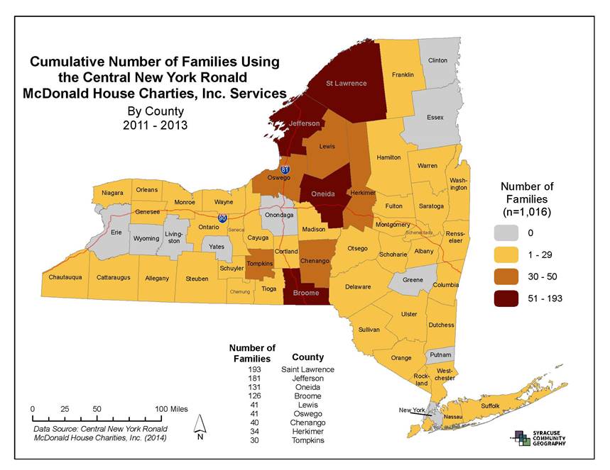
Cumulative number of families (statewide) using Ronald McDonald House of CNY 2011-2013
Project Selection and Funding
SCG projects are selected on an application-basis from grassroots, non-profit, and community-based organizations, as well as local municipal agencies. SCG does not charge fees for conducting the community geography projects, but does have several stipulations for organizations and agencies whose projects are selected, including active participation; collaboration and a commitment towards sharing data and results with the community at large. Funding for SCG is provided from the Maxwell School of Citizenship and Public Affairs and the Geography Department at Syracuse University. SCG also publishes MapSyracuse which is a new interactive web-based mapping tool containing mapped data specific to Onondaga County, NY. MapSyracuse is powered by Esri’s ArcGIS Online and is a free resource that allows users to select from over 100 layers of data to create, save and print customized maps at scales ranging from a neighborhood block to the county. MapSyracuse also includes a tutorial.
“Most of my project requests come from mission driven community-based organizations (ranging from grassroots, neighborhood groups to statewide coalitions. My community partners often provide me with data their agency or group has collected because they are interested to visualize their own data in new ways so that they can make better informed decisions. In this way, the data contributors are largely the partnering agencies”, notes Robinson. Syracuse area Community Activist Aggie Lane has been involved in two SCG projects that benefited from the local mapping efforts: The Partnership for Onondaga Creek (POC) and the Urban Jobs Task Force (UJTF), both community-based groups. “SCG was very helpful to both groups” says Lane. “For the POC, SCG maps helped us apply successfully for federal and state environmental justice grants. And for the UJTF, Jonnell’s team created area workforce profiles by zip code and ethnicity from some Onondaga County EEO workforce data which will be used to advocate for data collection practices that would measure the efficiency of local government’s workforce policies”.
Syracuse Community Geography also worked in partnership with Child Care Solutions and PEACE, Inc. on a project called, “Child Care and Early Education Program Availability in Onondaga and Cayuga Counties,NY (August 2013). Melissa Hidek, Grant Coordinator for PEACE, Inc. notes “Because of Community Geography’s strong relationships with local institutions holding helpful data, not only did we receive great, detailed maps of publically available information – like poverty rate, children in poverty, and trends in these areas – we also received maps showing the location of child care providers receiving child care subsidies from the Department of Social Services and where households receiving TANF (Temporary Assistance for Needy Families), Medicaid and other safety net programs were concentrated.”
The SCG program provides a model for discussion for the geospatial analysis of similar statewide public health and social service issues. Though phenomenally different in the many localities across the state, many of our current public health and human services and community issues could be geospatially analyzed in a conceptually similar SCG workflow. Particularly in context of bringing the technology – and its associated benefits – to individuals who benefit the most and in the greatest need. Given the very limited availability of geospatial tools or capacity at the local level in health, social, and community service programs across the state, it begs the question “Why not?”
Robinson accepts project requests on an ongoing basis from community based organizations and public agencies on a rolling basis. While it’s too late to submit a project request for students in Spring Semester 2015 classes to assist, SCG welcomes project requests at any time and groups can request projects online.
Get to know SCG and bring citizen-based mapping initiatives to your New York State community.