
Location
The Seneca Nation of Indians (SNI) is a federally recognized tribe located in what is now Western New York State. It consists of five territories. These territories are adjacent to the counties of Allegany, Cattaraugus, Chautauqua, Erie and Niagara in an area of the state where communities are primarily rural in geographic location. The territories are not contiguous and each is unique in its economic, social, and environmental profile. With 53,947 acres, the Seneca Nation controls and holds a significant land base in Western New York. The Seneca Nation of Indians traditionally lived in New York between the Genesee River and Canandaigua Lake and as far south as northwestern Pennsylvania and Eastern Ohio; however, currently the Nation is located strictly in the Western New York area.
In two different offices (Irving and Salamanca) nearly forty miles apart, Nation GIS staff communicate daily on a wide range of tribal GIS projects. The GIS Division is a part of the Community Planning and Development Department. The SNI-GIS Team consists of Ms. Gerri Jayne Jimerson GISP (tribal member) who has served the Nation for nearly 14 years, Todd LaQuay GISP, who covers the Cattaraugus Territory and has been with SNI for 11 years, as well as Trever Annis who handles GIS duties on the Allegany Territory.
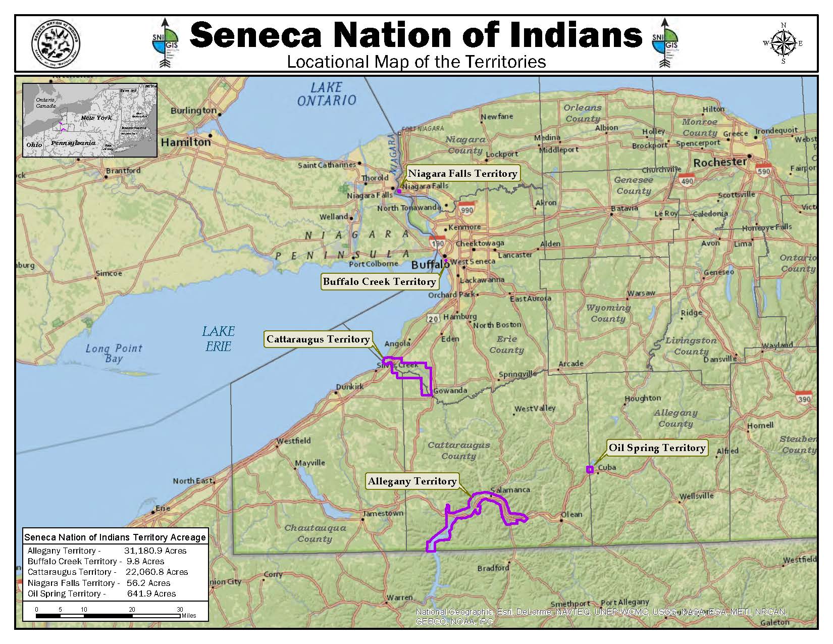
Lands of the Seneca Nation of Indians in Western New York State
The GIS Program
The SNI-GIS program utilizes the suite of ESRI’s ArcGIS technology based on an Enterprise Geodatabase system. While the GIS Team uses the ArcGIS desktop client, non-technical coworkers utilize Flex-based web applications customized for specific user departments and agencies. As the GIS group coordinates data collection in the field, they also utilize GPS technology from Trimble Geo XH’s, TerraSync, GPS Pathfinder Office, along with ArcGIS Mobile. Portal for ArcGIS has also been recently installed and they are looking to utilize this software and maps developed with it to put the GIS capabilities into more hands.
SNI-GIS staff work directly with the Community Planning & Development Department preparing maps for project planning for ownership and feasibility. Maps and other related geographic information are provided to other Seneca Nation departments to facilitate decision- making and planning for all. For example there is ongoing mapping of critical environmental areas of concern on the Cattaraugus Territory. This mapping was used in conjunction with a grant submittal in which funds were awarded to protect the endangered Blanding Turtle. The mapping provided has been a vital service and critical to preservation in some cases.
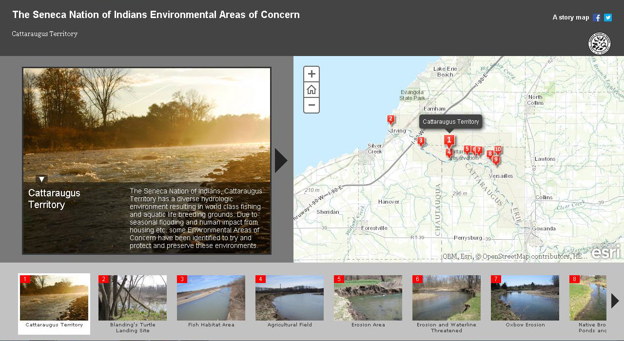
SNI-GIS staff uses Story Maps to illustrate important tribal mapping efforts which focus on current environmental and conservation issues
Additionally SNI-GIS staff maps are prepared to cover tribal issues including transportation systems, economic development, and social and demographic analysis. GIS staff utilize several public data layers made available by CUGIR, NRCS/USDA , local counties (Allegany, Cattaraugus, Chautauqua, Erie, and Niagara). The GIS Team also creates data utilizing GPS technology for inventory of boundaries, utilities, transportation, and addressing to name a few. They also just contributed their Indian Reservation Roads (IRR) database schema to the Tribal GIS Group who is working with the Bureau of Indian Affairs (BIA).
Other information sources, such as the descriptive Story Maps on the SNI GIS website, provide perspective on important SNI historical events such as impacts to the Nation relative to the U.S. governments building of the Kinzua Dam on the Allegany River in 1965 to help mitigate flooding downriver in the City of Pittsburgh, Pennsylvania. From the Story Map “Allegany Pre and Post Kinzua Dam”:
“The Kinzua Dam, located on the Allegany River in Warren County Pennsylvania, was built to protect the City of Pittsburgh, Pennsylvania from future flood damages. The Army Corp of Engineers and various federal agencies chose to disregard the land of the Seneca’s when considering the consequences of the dam. The building of the 108 million dollar Kinzua Dam broke a Federal – Iroquois treaty, the Canandaigua Treaty of 1794, making it the most tragic event of the Seneca Nation’s contemporary history.
Article III of the Canandaigua Treaty of 1794 states: ‘Now, the United States acknowledges all the land within the aforementioned boundaries, to be the property of the Seneca Nation; and the United States will never claim the same, nor disturb the Seneca Nation, nor any of the Six Nations, or of their Indian friends residing thereon, and united with them, in the free use and enjoyment thereof; but it shall remain theirs, until they choose to sell the same, to the people of the United States, who have the right to purchase.
The Kinzua Dam, completed in 1965, destroyed approximately 10,000 acres of ancestral Seneca land, leaving 136+ families no alternative but to relocate to widely spaced rural surroundings. The Dam also destroyed the old Cold Spring Longhouse, the ceremonial center of Seneca traditional life along with several cemeteries as well as hunting, fishing and gathering lands. The Seneca Nation received little monetary compensation.”
Amazingly, the SNI-GIS Team does not rely on any consultants to support their work, and thus far have been capable of handling everything in-house. And if that is not enough, the GIS Team has developed a GPS training course for their Utilities and Environmental Departments utilizing Trimble GeoXH’s and Juno handhelds running TerraSync software. GIS staff has also handed down their knowledge to other SNI personnel on the use of Ground Penetrating Radar equipment. Future SNI-GIS projects are anticipated to include working with the SNI Marshall’s Department in collecting accurate electronic data regarding accidents on SNI Territories. There are also plans to begin inventorying infrastructure assets (gas, water, electric) to create a comprehensive database for the SNI Utilities Department. Also, ArcGIS Pro may be launched to a few users.
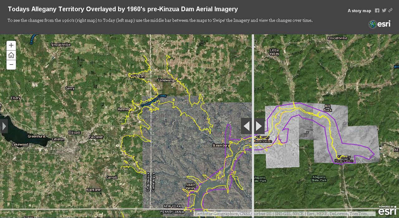
The 1965 U.S. Army Corps of Engineers Kinzua Dam dramatically changed the Seneca Nation landscape
Making a Difference
SNI-GIS staffer Gerri Jimerson notes “SNI departments who work with us on a daily basis would say our GIS services and products are an essential tool. We have a unique responsibility to the tribe to make our history from the past come alive digitally and to also document what is occurring on our lands currently.” Todd LaQuay adds “There is no greater service than serving for a government because in essence you are serving the people. Tribes can now begin to document their history not only orally – as in tradition – but also in a digital form.”
“There is always room for expansion”, Gerri continues, “one of our goals is to get more users to embrace geospatial technology, play around with it and see where they can go with it. We believe the “geospatial” profession is going to become widely known as more non-technical users access easy-to-use products such as Google Earth. We are in a special place and really excited to be part of it.”
Both Gerri and Todd presented at the 2014 ESRI International Users Conference in San Diego. Their presentation focused around the Story Map “The Kinzua Dam from Past to Present” (located on their website) it was based on identifying the need to bring historical maps into the digital age, to preserve history so the next generation can understand what their ancestors experienced. Utilizing a large format scanner and ArcMap with the ArcScan extension, valuable data was extracted from original 1960’s Army Corp of Engineers Mylar survey maps. These maps provided SNI-GIS with historical data for the Allegany Territory lands lost due to the construction of the Kinzua Dam. This was presented during the Tribal / Indigenous tract along with Map Gallery submissions.
Dedication of the SNI-GIS staff does not go unnoticed notes Lucille White, Acting Director Community Planning & Development Department:
“For those who have not had an opportunity to work with or be a part of GIS program, it goes well beyond being just mapping as a management tool. It is an analytical tool that adds spatial awareness to invaluable data that is captured, maintained, monitored and deconstructed. It affords an opportunity to review the past, gives an understanding of the present and allows you a glimpse into the future. It organizes information in such a way that you are able to demonstrate patterns that would otherwise go unnoticed, which can drive decision making by leadership for future generations. Just as roads and infrastructure connect communities and people, GIS creates arterial pathways that reveal connections between data and systems”.”
All staff are members of the WNY GIS user group and NYS GIS association though to date have not participated in other New York State events like the Geospatial Summit or NYGeoCon. Given the historical and societal context of their work, their contribution to the broader GIS community would be a real plus.
Three Seneca Nation of Indians staff. Mixing and mashing modern technology with our Nation’s ancestry on the Southern Tier and in Western New York. Along The Blue Highways of GIS.
Thanks for reading. Ësgö:ge’ ae’ gawe:digwa:h.