
At the Fall 2015 NYGeoCon in Albany, I presented a paper focusing on specific GIS applications which provide a framework for establishing and maintaining GIS/geospatial programs in local governments (villages, towns, cities, and counties) across New York State. I refer to these applications areas as the Geospatial Common Core, many of which are integrated with local government office and administrative business systems. Others are utilized in the support of regulatory reporting programs. Together, the Geospatial Common Core contributes in helping build sustainable geospatial capacity for local governments.
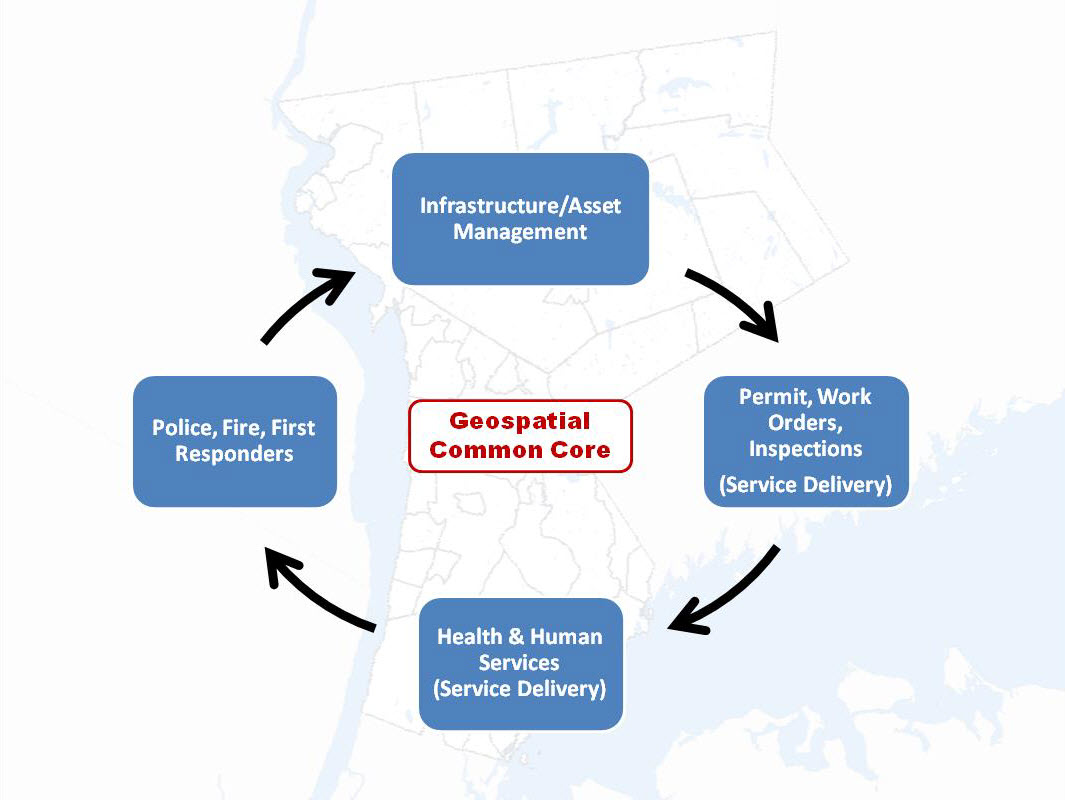
GIS Common Core application areas in local government
Since NYGeoCon, I have used this initial presentation as a starting point to examine and discuss each of the Geospatial Common Core areas in further detail as part of individual blog posts. In early December 2015 I submitted Part 1: Infrastructure and Asset Management which focused on the growing and critical role local government GIS geospatial programs continue to serve in rehabilitating and maintaining the decaying statewide public infrastructure. And it comes as no surprise that this December blog post was submitted and made available ahead of the numerous statewide signature infrastructure related projects itemized in Governor Cuomo’s proposed 2016 budget. Alignment of statewide local government geospatial programs with the public works, surveying, and engineering communities is strategic and should not be underestimated.
Geospatial Common Core Part 2: Work Orders, Permitting, and Inspections (WOPI)
With 1,607 general purpose local governments across New York State, the WOPI Geospatial Common Core component is ubiquitous as part of daily work flows at all levels of government. Rarely a minute goes by across the state without some kind of government permit or work order being issued, an inspection taking place, licenses or violations being issued, or geographic data being collected in related asset management systems. These systems are uniquely integrated with the Geospatial Common Core components (infrastructure and assets) reviewed in the December post. Nearly all WOPI programs are institutionalized and mandatory at the local level, funded through annual operating budgets, and often aligned with local, county and state regulatory programs. As such, WOPI systems provide an excellent area in helping justify and build GIS capacity. (Just to get a sense of the magnitude of these programs, particularly in larger New York State municipalities, visit these links: Buffalo including one 12-month period that included nearly 19,000 citizen-requested inspections; Rochester, and Albany (Albany data from www.data.ny.gov)
For decades these government workflows and data collection systems were largely paper-based and therefore data could not be integrated into geospatial systems being implemented in the same organizations. It wasn’t until a series of geospatial and technology advancements came to fruition that finally created a framework to better manage and integrate PWOI datasets into GIS programs. Such advancements included:
- Automation/Standardization of tax maps: In spite of New York State’s pathetically outdated tax map maintenance regulations (a.k.a Part 189) which still only require the publication of hardcopy maps , the automation and standardization of tax maps in context of both attributes, geometry, and unique section, block, and lot (SBL) number have created an authoritative identifier for every parcel in each municipality. In doing so, providing a database schema for the POWI systems.
- Uniform Addresses: The evolution of E911 systems has led to the standardization and significant improvement in the quality of addresses throughout governments. In many locations, addresses are stored as attributes of digital tax parcel datasets.
- Desktop Hardware and Software: As personal computers and laptops became cheaper and faster, developers in the permitting, work order and inspection software space were able to develop more intuitive and functional software programs for a much broader audience – particularly with the non-technical Single seat, desktop client software installations continue to be of great value to smaller organizations.
- Integration with GIS Software/Mapping Platforms: As WOPI desktop software client software became more functional and available to an expanded user base, so did integration with GIS software programs. Over time, local governments began to realize GIS was the perfect platform to design and create integrated GIS-centric POWI (and asset management) systems using spatial relationships as a way to manage, coordinate, and analyze work activities. While ESRI has built many business partners in this space, as well as building their own customized applications, other WOPI software vendors are using open source mapping software to support their mapping needs.
- Server/Internet/Cloud Technology: Server/internet/cloud technology advancements have turned local government office/business systems upside down moving systems away from managing data and maintaining applications in the single-seat, heavy client architecture model. While single seat programs still fill a niche, nearly all government computing systems have moved to service technology enabling staffs – and increasingly the public – to share common applications and enterprise data using only a browser. Specific to this discussion, nearly all POWI vendors now offer their services and solutions in the Cloud – including a strong and robust geospatial component.
- Wireless and Mobile Technologies: One of the last pieces to help move WOPI systems into the forefront of local government geospatial development are wireless and mobile technologies. While there are still many obstacles for small to mid-range sized governments to fully deploy wireless/mobile, software companies supporting WOPI business solutions continue to make it easier and more cost effective for local governments to implement geospatial wireless and mobile apps.
These technologies now enable governments to interact “live” with enterprise POWI systems and databases from the field. As an added benefit, these expanded functions enable managers to better communicate with and administer field resources such as rescheduling inspections or reassigning work to other field personnel. New applications even include voice-to-text functions which enables users to record data and notes without typing. This function helps users save time and improve workflows.
Though often not part of the discussion, better utilization of field resources (staff) can also contribute to the better optimization of vehicles and fleet management components. Automated vehicle locator (AVL) components are now available with many GIS software platforms and can provide significant long term cost savings in optimal routing systems and applications.
(Side Note: Ironically, one of the earliest supporters and sources of funding for local government GIS programs in New York State was the former NY State Archives and Records Administration (SARA) though now known as just the State Archives (SA). Charged with assisting governments in the long term management and preservation of records, SARA had an early vision of how GIS technology could be used to help more efficiently create and manage electronic records, of course including government program areas such as permitting, work orders, and inspections. Unfortunately the technology had not yet evolved to support and implement many of the GIS concepts SARA was attempting to champion at the time. Coupled with waning management and financial support, State Archives role in this regard has been significantly reduced.)
Software Options: To be expected, there is an increasing number of software vendors in this space including, but not limited to, systems such as Accela GIS and CityWorks (both closely integrated with ESRI software) or more independent systems including cloud-based offerings like ViewPoint, Citizenserve and Govpilot. The Capterra website provides a comparison and review of many similar government business software products.
Westchester County GIS has recently implemented VueWorks (another product closely integrated with ArcGIS Server) at Westchester County airport to support work order issuance and tracking as part of a much larger Federal Aviation Administration (FAA) compliant mapping system/implementation effort.
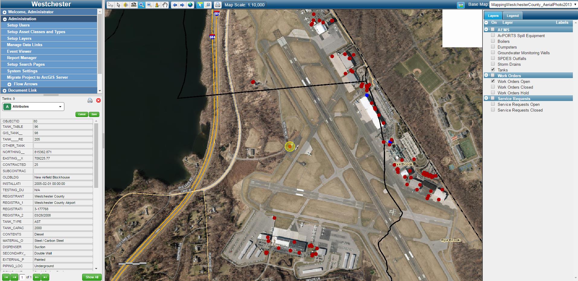
Work Order software products which are integrated with GIS applications are increasingly being used in large facilities management systems such as the one at Westchester County airport.
Software Consulting Associates (SCA) based in Red Hook, NY produces a suite of software products in WOPI space most of which are bundled together in their flagship enterprise product Municity 5. Municity 5 offers a wide range of mobile/cloud-based POWI system functionality. SCA uses several open source components to support GIS and mapping integration. For Westchester County clients, the Municity viewer consumes publicly available map services to add more detailed geographic content to the viewing window.
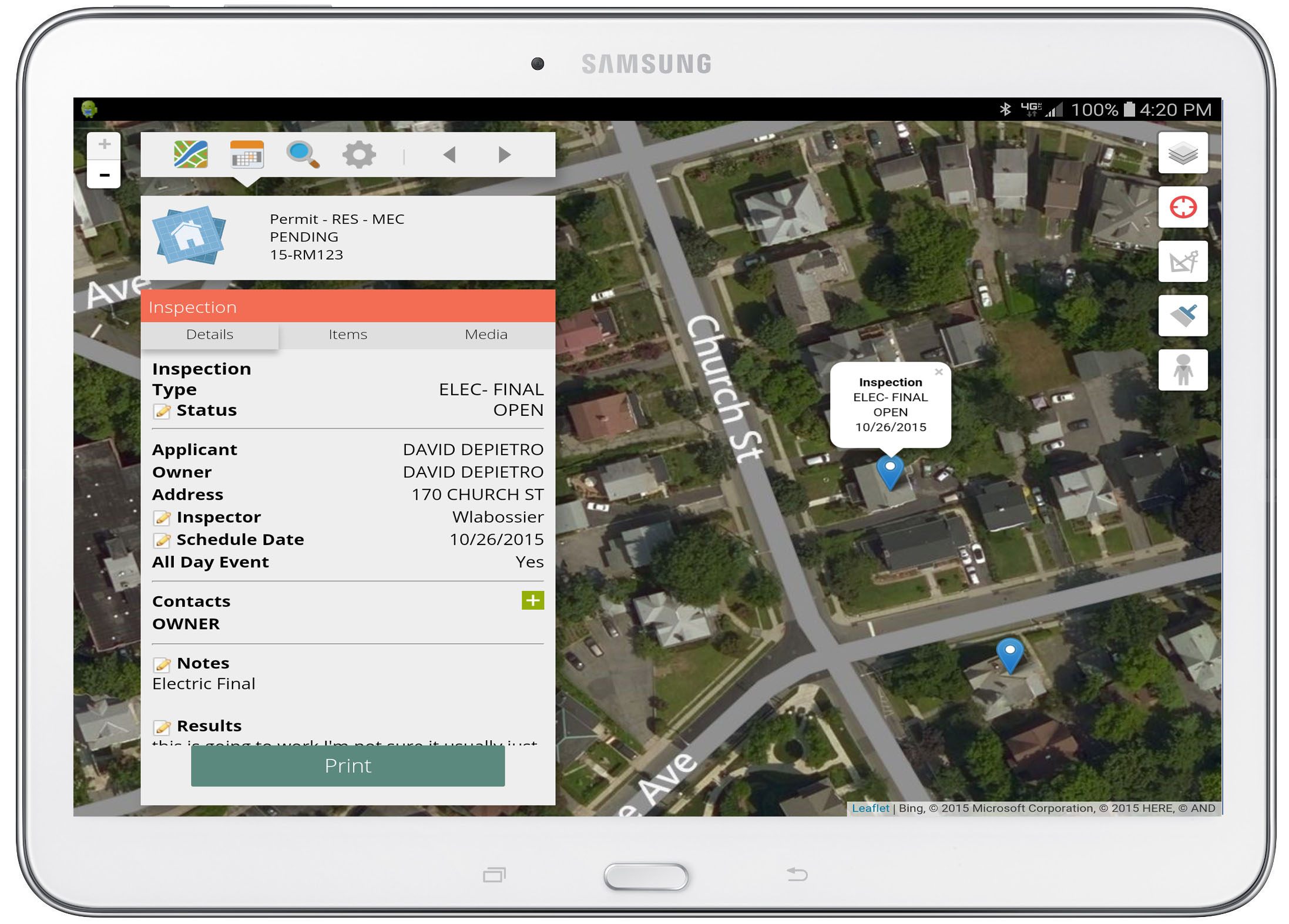
SCA has developed a suite of WOPI applications which are mobile-based as illustrated on this Samsung tablet.
Summary: WOPI systems increasingly provide strategic geospatial for enterprise decision-making support at all levels of government across the Empire State. Organizations investing and integrating WOPI systems with GIS will do well towards building long-term sustainable geospatial programs.
Next: Health and Human Services (Service Delivery)