
The last couple years I’ve been watching the growth of GeoNYC Meetup group and continue to be amazed at the far-reaching representation of individuals and companies now involved in the broad field we call “geospatial”. One person shops, start-ups, open source/open data techies, apartment and loft based companies, strong business and private sector representation, community based mappers, and everything in-between. A much different composition and representation than that of the other existing statewide geospatial/GIS communities and organizations that I and other colleagues of my GIS generation came through. To date I have published three previous blog posts focusing on other contacts made through GeoNYC: Mapzen, Mapillary and NiJel.
Spatial Analysis and Visualization Initiative (SAVI)
Also establishing a niche in the expanding geospatial space are community facing programs associated with and supported in academia environments. One such program, which I was also introduced to through GeoNYC, is the Spatial Analysis and Visualization Initiative (SAVI). It was launched in 2013 and is at Pratt Institute. SAVI is a GIS-based research lab and service center that focuses on mapping, data analysis, and visual storytelling, providing students, faculty, and community groups with the resources they need to communicate information in compelling ways. The first and only New York City college-based GIS lab open to community organizations and civic groups, SAVI offers computer access, technical assistance, professional training, workshops, and research that empower local organizations to create their own visions to improve the quality of life for their clients and constituents. At Pratt, SAVI supports students and faculty whose work reaches beyond the Institute’s campus to engage and benefit New York City.
Leading the SAVI program is Jessie Braden, who was appointed Director in the Fall of 2013. Prior to SAVI, Braden spent three years at the Pratt Center for Community Development, a non-profit affiliated with Pratt Institute that provides technical services to community organizations. She has also been an adjunct professor of GIS in Columbia University’s Graduate School of Architecture, Planning and Preservation Program since 2010. Braden initially started SAVI with Pratt Programs for Sustainable Planning and Development (PSPD) Professor Juan Camilo Osorio as a volunteer side project in 2011 with the guidance of then Department Chair John Shapiro. In addition to PSPD, Pratt Center and the Graduate Communications Design Department offered their official support, allowing the lab to come to fruition and solidifying SAVI’s focus on communities AND design. Pratt Center also secured a $670,000 grant from NYC City Council to renovate a physical space on Pratt’s campus so SAVI can serve community organizations and students. During the time the program was being institutionalized at Pratt, Osorio took a full-time position as Director of Research at the New York City Environmental Justice Alliance. Though not involved in day to day operations, Osorio remains a trusted advisor to SAVI.
SAVI consolidates the Institute’s GIS resources with an eye to social benefit. This means putting data analysis in the hands of community activists, students, and faculty. It also means making the products of GIS expertise visually legible and compelling so that the stories they tell will have as much impact as possible.
“At the end of the day, visual representation is as important as the quality of data analysis,” Braden observes. “Our vision for SAVI is to produce outstanding multidisciplinary projects with the highest-caliber visual display— making the invisible visible, both inside and outside Pratt’s gates.” Its Jessie’s belief, which I share, that a well designed map should be able to stand on its own. Such a product enables the reader to conduct the “spatial analysis” based on the distribution and rendering of the map data itself – with only minimal accompanying narrative to explain or describe the map.
Braden points to specific mapping projects which exemplify the SAVI cause:
Neighbors Allied for Good Growth
In the Brooklyn communities of Greenpoint and Williamsburg, Neighbors Allied for Good Growth (NAG) aims to recapture the waterfront, reduce local environmental hazards, and advocate for public policies promoting healthy mixed-use communities. NAG enlisted SAVI to determine the extent of pollution that has occurred throughout the history of Greenpoint and Williamsburg. SAVI underwent an arduous process of data mining and assessment of DEP, EPA, and other agency records to locate areas of concern. SAVI then combined this cleaned and distilled data, with other demographic information, into a simple story told through a website called ToxiCity.
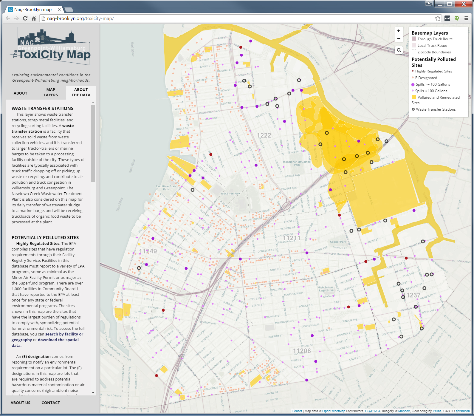
SAVI compiled information from federal, state, and city sources under several different environmental programs in building ToxiCity interactive web application. The application is built with several open source components.
Rita Pasarell, NAG Board Chairperson, comments on SAVI’s support on the ToxiCity project:
“Jessie and SAVI were very collaborative and involved in the whole course of the project, which was very helpful for us as a small non-profit. After working on the back end of the map, she gathered feedback on the usability of the map, and she also came to several community meetings to explain the development and function of the map. Her work has definitely been beneficial for the Greenpoint-Williamsburg community– now we are able to see in one snapshot just how environmentally burdened the area is. Also, when she speaks about the map’s development, she makes it easy to understand for non-tech people– this is so useful.”
Brown University’s Annenberg Institute for School Reform/Coalition for Educational Justice (CEJ)
The Coalition for Educational Justice, with assistance from Brown University’s Annenberg Institute for School Reform, seeks to end inequalities in NYC public schools. SAVI performed extensive research on a number of education indicators as well as health and demographic information for selected school districts. Maps were created that highlighted problem schools, test results, after school programs, graduation rates, poverty, health, and more. These maps allowed CEJ to engage with community members regarding the state of their school district compared to other areas in the city. Graphic design firm HOUSE of CAKES stylized the final maps for optimal storytelling power.
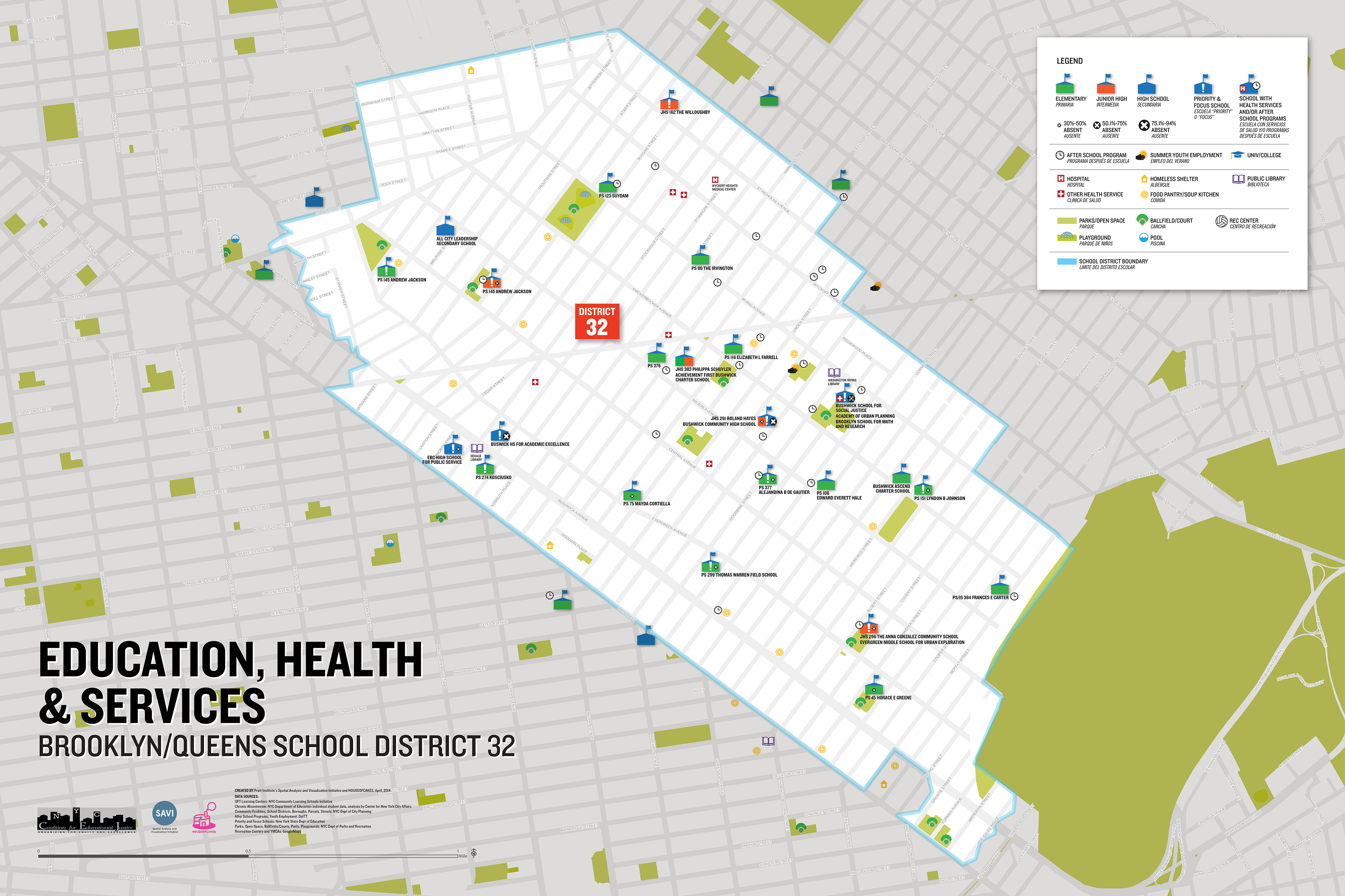
The Coalition for Educational Justice (CEJ) includes the following member organizations: New Settlement Apartments, New York Communities for Change, and Make the Road New York.
Commission on the Public’s Health System
SAVI worked with the Commission on the Public’s Health System (CPHS) to map health care service availability and changes over time. CPHS was seeking anecdotal evidence to illustrate the inequitable distribution of planned hospital closures in New York City, and they have further hypothesized that a large number of former hospitals are now luxury residential buildings. In response, SAVI researched hospital closures in the past 20 years to determine the current land uses of these properties, using a variety of sources including local and state health agency data, newspaper archive searches, and current and historical NYC GIS data. SAVI also mapped current hospital locations, travel times, service availability, and factors that bar easy travel to these locations for vulnerable populations.
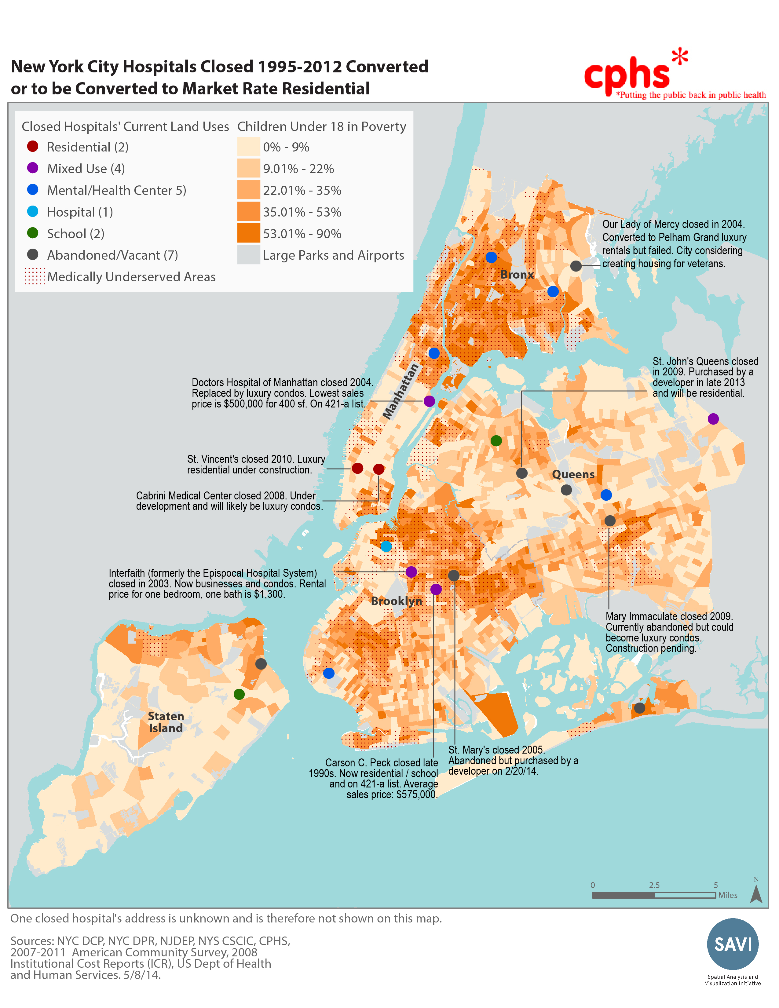
The conversion of hospitals to high-end luxury apartments is of significant concern across New York City impacting the availability of local health care services in many areas.
SAVI has lent their mapping and data analysis skills to numerous other groups including: Brooklyn Arts Council, Greenpoint Chamber of Commerce, Jamaica Center BID, Brooklyn Navy Yard, and many more.
Additional Resources
Being affiliated with an academic environment like Pratt provides other ancillary benefits for SAVI. Braden oversees a wide range of other products and services including tutorials and technical assistance on Esri ArcGIS, QGIS, and CARTO software to current Pratt students. Braden also continues to develop and enhance Pratt’s GIS and Design Certificate program. Run through the School of Continuing and Professional Studies, the program provides 225 hours of training on the latest geospatial tools, including open source options, with a heavy focus on cartographic design and storytelling.
Summary
While still establishing its metro NYC presence, the SAVI intent mirrors a similar GIS community-based programs such as the Syracuse Community Geography program which has been highlighted previously in eSpatiallyNewYork. SAVI is also building a program using geospatial tools to help support community-based health, social, and environmental justice projects. Focusing on bringing the technology – and its associated benefits – to individuals and communities which benefit the most and in the greatest need.
Get to know SAVI and bring citizen-focused, community-based mapping initiatives to your metropolitan NYC area. Community-based organizations can contact SAVI for lab access and the initiative performs pro bono mapping and data analysis services when possible.
Contact Jessie Braden at savi@pratt.edu. On Twitter: @prattSAVI