Systems Development Group (SDG) provides real property, imaging and GIS-centric software and professional services to government, education and private sector companies. The Company provides clients with the appropriate technologies to cost effectively improve tax payer services while reducing operational costs. Clients achieve operational efficiencies with SDG’s blend of expertise in assessment, imaging, GIS and software administration tools and professional services. SDG currently collaborates with state, county and local government agencies.
Location: 44 Trenton Road, Utica, New York 13502.
Website: www.sdgnys.com
Email: info@sdgnys.com
Phone: (315) 798-1328
Employees: 8
Established: 1991
Flagship Product: Image Mate Online (IMO) Real Property Web Portal
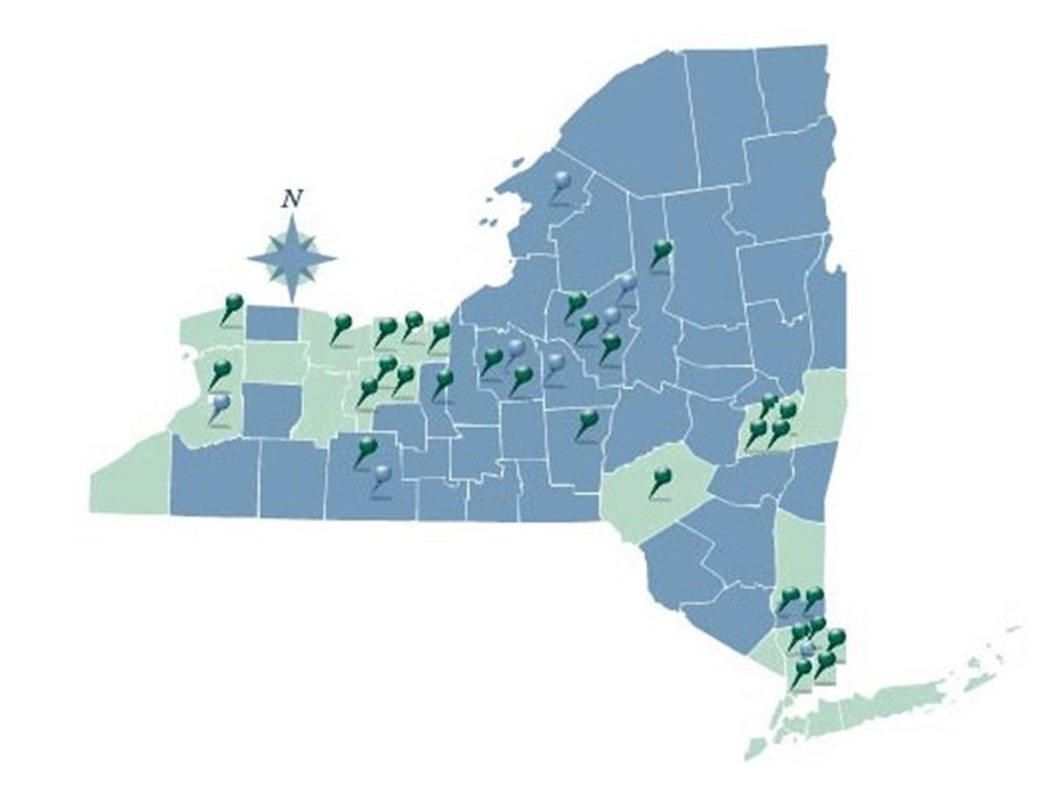
The New York State SDG IMO coverage area. Full County services are rendered in blue. Individual City or Town services are denoted by pushpins.
Brief History
In the New York State Real Property System ( RPS V3) 1990’s era, NYS challenged SDG by noting it was technologically impossible to display photos during a live RPS V3 session. SDG knew otherwise from similar projects performed for their parent company (Lanier Business Systems). Code being used to add imaging support to hospital applications was leveraged to build an initial application saving the Towns of Whitestown and New Hartford over $50,000 of previously ear-marked monies for Tyler-CLT Landisc street level imaging projects.
As SDG systems engineers and developers grew more familiar with assessment administration, opportunities arose to assist assessors with the development of line of business valuation software utilities including the Assessment Sales Analysis Program (ASAP) search engine. A combination of these software tools contributed to the successful NYS Office of Real Property Tax Services (ORPTS) RPSV4 launch.
RPSV4 was originally developed as a client server – “thick” desktop application. However, within a few short years, the internet and web application (browser) paradigm entered the software mainstream. The web quickly became a natural conduit to share real property information with the public and between Government departments and agencies. The next “organic” step forward for SDG was the development of a web portal for real property and assessment information – Image Mate Online (IMO).
IMO quickly gained popularity with NYS Counties and local municipalities throughout the early 2000’s. The State Real Property Tax Administration Technology Improvement Grant Program (RPTATIP) Grant program in 2006 and 2007 helped open the door for many additional County Real Property and Assessment Departments to deploy IMO portals. A large percentage of RPTATIP grant projects included IMO due largely to:
-
- Return on Investment (ROI) – The City of Yonkers experienced a 70% reduction in Assessment Office foot and telephone traffic within their first year of IMO operations.
-
- Extensibility – Ease of building upon the IMO portal to create “one stop shops” for comprehensive parcel related information.
-
- Tight bindings with New York State Real Property and Assessment rules and best practices.
-
- Strategic partnerships, projects and connectivity with “best in class” players including Pictometry, Apex, ESRI, Google, VHB, TerraGo and Sewall
-
- Performance and scalability – The Onondaga IMO site performs over 2 million parcel searches a year. At 20% the size, nearby Seneca County – over 80,000 searches annually.
-
- Outpost extends IMO and live RPS data collection services to the field as a low-cost tablet mobile sister service.
Image Mate Online (IMO)
Image Mate Online [IMO] serves as the hub or “portal” for a government’s real property and assessment information. A typical IMO installation is a collaboration between the local government client, the SDG implementation team and contributing strategic partners. By design, IMO is highly extensible and offers connectivity and integration options with related spatial and parcel centric systems.
IMO sites are typically public facing, offering the tax payers easy access to detailed ownership, inventory, improvement, photo, sales, mapping and tax billing information. The application also includes intelligent links to local web mapping viewers and general web mapping services (Google Maps, Bing, etc…). Links to locally or third-party maintained GIS viewers create bridges from parcel specific searches to a full set of infrastructure layers valuable in inter-governmental data sharing.
IMO’s inherent flexibility can also greatly enhance the public’s understanding of and participation in revaluation projects. Having evolved from an imaging and forms processing technology kernel, IMO can serve as a 24×7 pipeline for property “owners and stake holders to interact with the municipality and their contractors while CAMA (Computer Assisted Mass Appraisal) and valuation work is in progress.
IMO services throughout New York State have become a staple for property owners and the professional real property community. IMO is heavily used by financial institutions, realtors, appraiser’s surveyors and developers. Having a robust IMO system available represents a high return on investment in the promotion of economic development. IMO’s greatest use by far is as an easy to use real property information “one stop shop” for the residents in a community.
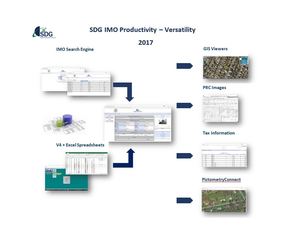
IMO is a “one stop shop” for a municipality’s parcel centric data. Target parcel selection is supported by the IMO user-interface or via third party CAMA systems, Excel spreadsheets and GIS Web Viewer API links. The IMO Detail Page serves as a portal to display and simplify access to relevant and diverse parcel information and web service resources.
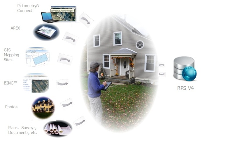
SDG Outpost Field Assessment System
Outpost data collection and inspections are streamlined using state-of-the-art mobile software and tablets. Time consuming post-inspection data entry is eliminated for both tabular assessment data and digital photos. Priority is always given to leveraging the Assessor’s RPS and Image Mate Online systems to provide for a powerful and efficient introduction of mobile technology to the assessment workflow.
A key component of Outpost’s success is building upon existing well-developed Image Mate Online and RPS ecosystems of content, applications and support networks. Outpost represents a mobile extension of proven
SDG IMO web portal services for their clients. With Outpost, the Assessor and field staff have a portable conduit to the entire assessment ecosystem. Outpost is a natural and flexible mobile evolution in the NYS assessment (RPS) software landscape. The Outpost user interface has been developed using the latest mobile software development technologies and has been optimized for tablet use. The Outpost system architecture is both flexible and extensible and as new mobile hardware options become available, the SDG technology team will modify Outpost to incorporate new mobile device capabilities. Likewise, the Outpost front end can be “re-fitted” for future upgrades to New York State assessment systems.
Outpost provides for:
- Improved assessment efficiency and accuracy with enhanced and integrated mobile assessment inspection and data collection tools.
- Consistency in parcel data collection and verification activities.
- Digital photo capture support for built in tablet cameras with automated RPS V4 upload.
- RPS V4 compatibility with upgrades to match changing RPS requirements.
- GIS and tax map image viewing available from the field.
- A powerful administration program to plan track inspection activities.
- Google Maps and GPS support to locate and identify difficult parcels.
- Real time remote support. The Outpost support team can access, monitor and provide “on tablet” technical assistance during field inspections.
- Optional integrated Pictometry oblique and ortho aerial imaging services via 4G connections where available.
Outpost supports Android tablet based “paperless” assessment field inspections and data collection projects. Assessment data and photos are auto-synchronized to the muni’s production database via secure wireless connections. The most common tablets being used are Samsungs running Android 5.0 (Lollipop) and above.
Corporate Position
“We take our local government partnerships and our shared responsibilities to the New York State taxpayers very serious. SDG’s track record, particularly with IMO, has been a continuous evolution driven by a willingness to always be open to the “what if” or “wow would this make a difference” questions and comments from our clients and partners that are out there busting it to improve the lives of New Yorkers. Like in the old westerns, the drumbeat of tight economic times has been playing in the background for longer than many of us care to remember.
The strongest players (public and private) that we are most inspired to work with, understand the urgency and stay inspired. With the forecast for a continued tight economy, we anticipate the continued acceleration of GIS being at the core and key to “good governance – line of business” services. Great looking maps added allot to presentations over the years. Now we see spatial technology hitting an invaluable higher gear right when NYS and can use it most.”
John Kelly
SDG – President
Contact: John Kelly johnk@sdgnys.com