
Company Name: The CEDRA Corportation
Location: 1600 Mosley Road, Suite 500, Victor, NY 14564
Website: http://www.cedra.com
Employees: 12
Established: 1985
 The CEDRA Corporation offers GIS based software for mapping, civil engineering design and modeling, surveying and database maintenance applications. CEDRA’s AVseriesTM suite of software operates directly within Esri’s GIS software (ArcGIS® 9.x and 10.x), thus eliminating the need to switch back and forth between various software packages. CEDRA software is developed entirely in-house and marketed worldwide to public works agencies, tax assessors, utilities, municipalities and private sector companies.
Complementing CEDRA’s Software Development Division is CEDRA’s Professional Services Division which has performed consulting projects throughout the U.S. and specializes in developing, populating and maintaining GIS databases. CEDRA’s Professional Services Division offers consulting services to clients for a multitude of applications including CEDRA-specific software solutions or can be totally non-CEDRA software related consulting projects. CEDRA staff is highly proficient in GIS Analysis, Data Capture, Data Conversion, Map Production, Routing and Custom Application Development in toth the desktop and server environments. As an authorized Esri business partner and reseller, CEDRA has a long history in the use and application of Esri’s GIS suite of software dating back to 1987.
CEDRA’s corporate mission is to provide services and software that improves the efficiency and productiveness of its clients. This goal is achieved by (a) developing software that is production oriented and (b) offering services that enable clients to streamline workflows. CEDRA believes the more automated a workflow can be made, the more efficient a client will be and a higher quality product will be produced. CEDRA offers Expertise, Experience and Commitment when undertaking a project.
Illustrative CEDRA products and services include:
Wayne County E911, Lyons, New York
Under this project CEDRA assisted Wayne County staff in developing the County’s E911 street database. Specifically, the work involved acquiring the NYS Street Address Mapping (SAM) data, extracting the street data for Wayne County, and working with the County in verifying and updating the street center line database for use in the County’s E911 system.
In performing this work, CEDRA staff was on-site at the County’s office performing the work and training County staff in the process. A workflow was developed and adopted by the County. Additionally, a training guide was developed enabling County staff to maintain the street center line data with their own resources.
In addition to establishing the street center line data set, CEDRA assisted the County in developing the EMS, Fire and Police polygon layers which are utilized by the County’s E911 system. Extensive polygon editing and topological verification was performed in developing these three polygon layers.
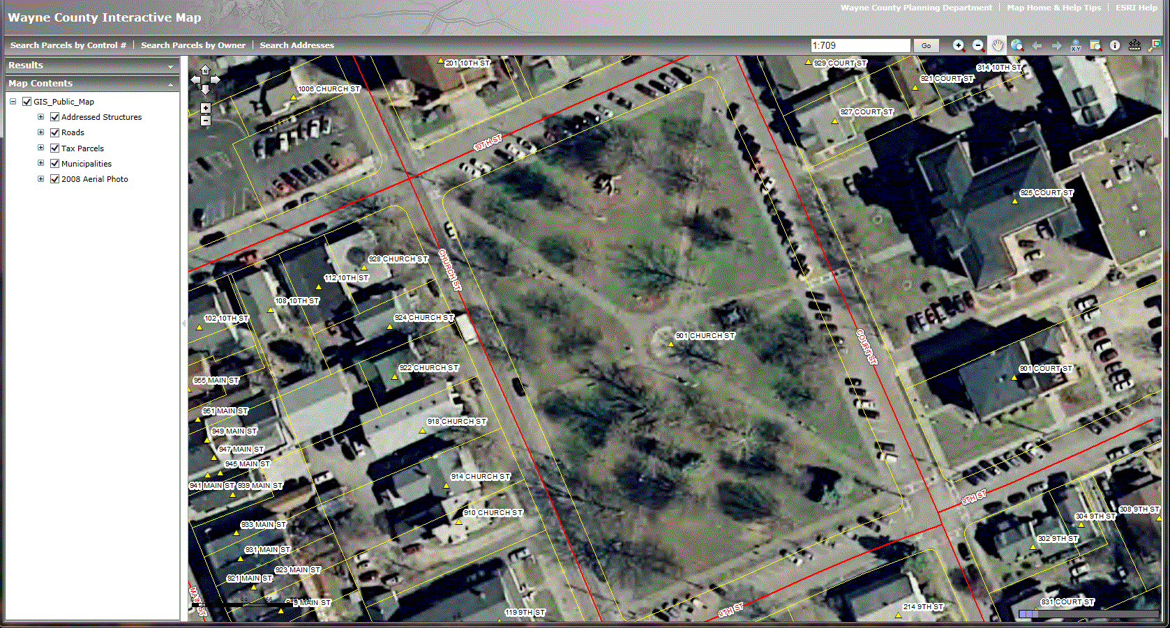
CEDRA’s Wayne County 911 address maintenance application is based on data from the NYS street address program and a customized
Heavy Truck, Wide-Load Routing, Albany, New York
This work involved the development of a 3D street network dataset for New York State and a GIS web based routing application tailored for routing heavy and wide-load freight vehicles. With over 200 bridge strikes occurring in New York State annually and over 2,000 nationwide, the need for a routing application specific for freight vehicles was identified by the New York State Energy Research and Development Authority (NYSERDA). Using USGS Digital Elevation Model data in conjunction with NYSDOT street, pavement and bridge data, a 3D state-wide street network data set was created with ArcGIS. The dataset accounted for vertical clearance, posted weight limits, speed limits, and roadway grade. The NYSDOT data was obtained through the NYS GIS Clearinghouse under its Data Sharing Cooperative program and other sources.
As part of this project, an ArcGIS Server JavaScript web application was developed enabling routes to be generated based upon the 3D street network and user-specified route parameters such height limit, weight limit, desired speed and type of cargo, if appropriate. The web application consisted of a custom user-interface that integrated Esri’s Network Analyst extension with the 3D street network. Routes with turn by turn directions can be exported to Keyhole Markup Language (KML) format providing users the ability to download to mobile navigation devices and used with Google Maps. Furthermore, the application enables the user to generate multiple routes with each route appearing in a different color. The application also provides the user the ability to display various cartographic and orthoimage base maps, including Google-based maps. This project involved extensive use of Esri’s Spatial Analyst and Network Analyst extensions, the ArcGIS Server software, Esri’s JavaScript API and HTML programming.
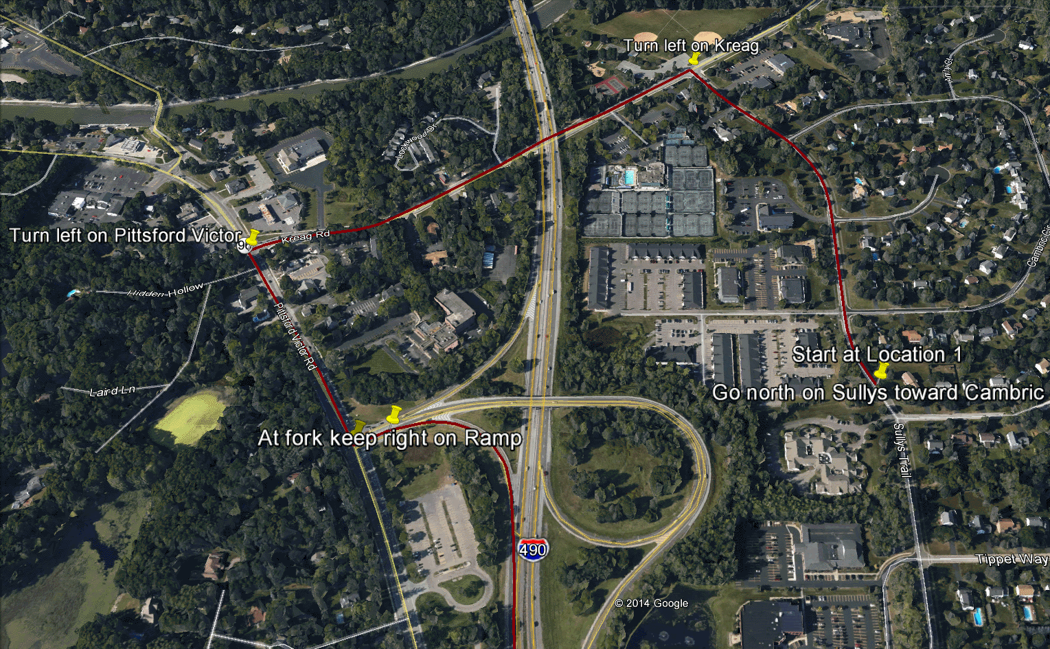
The heavy truck / wide-load application includes several NYSDOT data sets available through the NYS GIS Clearinghouse and a customized ESRI server technology application utilizing several extensions. Users can also export to KML for use in mobile navigation devices.
PECO Application Support, Philadelphia, Pennsylvania
GIS Administrators have long been dealing with how to get their GIS data into CAD environments, be it AutoCAD, Bentley and other CAD systems. One client CEDRA has been working with in this regard is PECO Energy located in Philadelphia, Pennsylvania.
PECO Energy services nearly 1.6 million electric and over 511,000 natural gas customers and is the largest combination utility company in Pennsylvania. It has a franchise utility service area of 2,100 square miles with a population of 3.8 million people. Much of PECO’s electric and gas data resides in their ArcGIS enterprise GIS while construction drawings are generated and maintained in Bentley CAD. Having been ArcGIS users for over 10 years, PECO’s enterprise GIS is extremely robust, up-to-date and contains information which needs to be accessible and be integrated with construction drawings. CEDRA was contracted to develop a solution to seamlessly transfer GIS data to the Bentley CAD environment as to avoid the unnecessary effort and cost of maintaining data in duplicate environments.
To this end, CEDRA worked with PECO staff to develop a customized application utilizing ArcGIS Online and ArcGIS Desktop a custom geoprocessing service and the CEDRA-DxfExport software. The goal of the GIS data transfer is to export the ArcGIS data from the Esri environment preserving point feature symbology, line styles, annotation and layering information into a format that the Bentley system can process. Another requirement was to minimize the amount of user interaction.
To make the extraction of the GIS data as easy as possible the amount of information required by the user was kept to to the following:
- Identify the area to be extracted
- Specify the name of the DXF file to be created
- Specify the desired output scale
- Select whether a DXF, PDF or both formats were to be created, and
- Specify the email address to which a confirmation message of the extraction’s completion should be sent.
Once the user has entered the above, a Python based geoprocessing service is executed to begin the extraction and generation of the DXF and/or PDF files. Before and after images are below illustrating how the utility ports the same features in a defined geographic footprint from one environment (ArcMap) to another (Bentley).
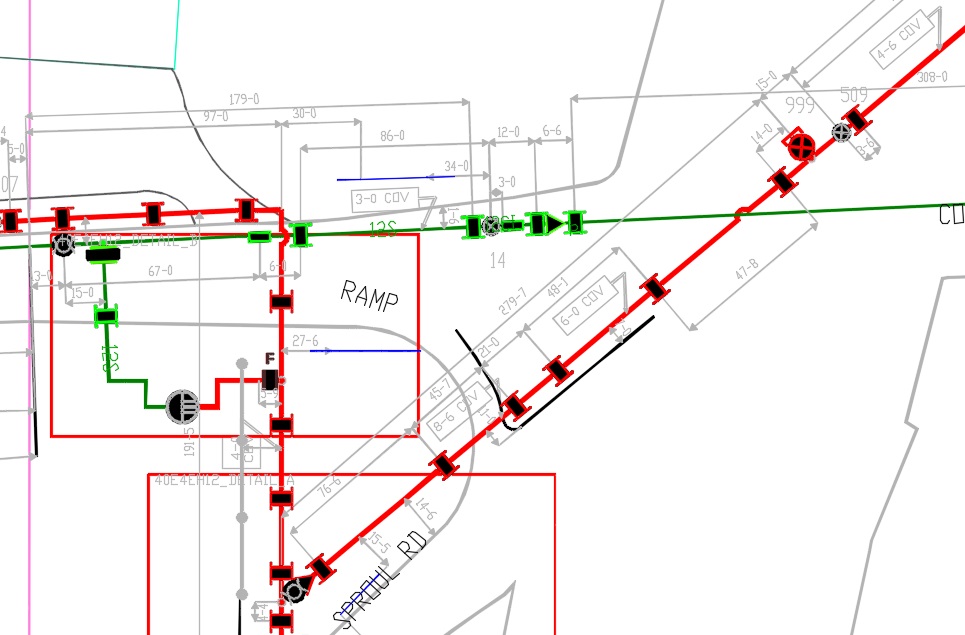
BEFORE: User defined geographic footprint (ArcMap)
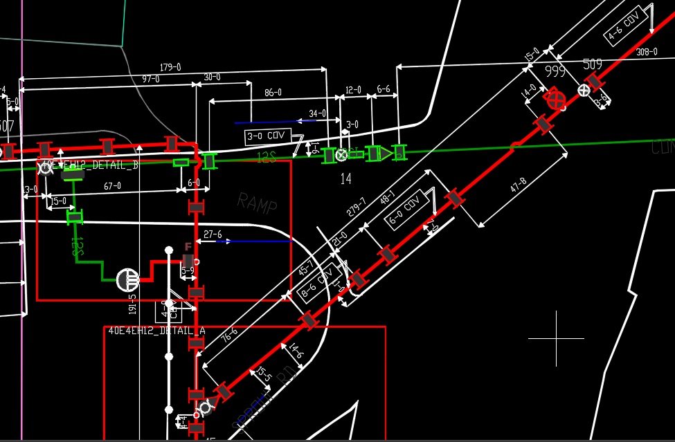
AFTER: Using the customized CEDRA “data transfer” utility, the same features/same geographic footprint rendering in Bentley CAD software.
Urban Forestry Management, Edmond, Oklahoma
CEDRA assisted the City of Edmond, OK in the development and deployment of a mobile based application which is being used in the ongoing inventory of the nearly 16,000 trees which are the responsibility of the City to maintain. Using iPad devices, staff from the Department of Urban Forestry collect a wide range of data on each tree including: species code, diameter, condition of leaves, condition of wood, GPS location and any special notes concerning the tree. Using a form, Urban Forestry staff can select from a pre-defined list of species codes, capture a GPS location and take a digital image of the tree. Once the data has been collected, this information is synchronized with the City’s SDE geodatabase nightly.
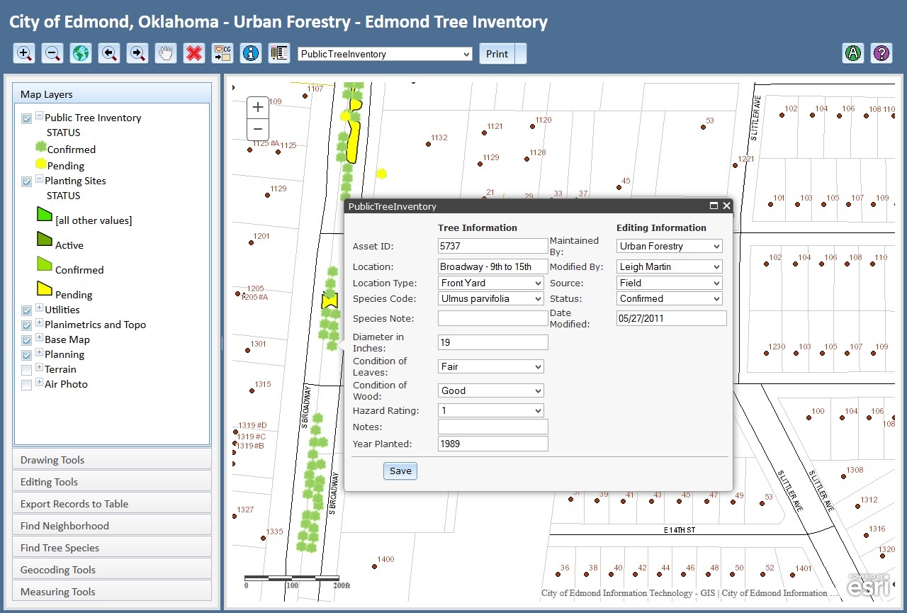
Cities and urban centers are increasingly using easy-to-deploy/use mobile applications to collect and maintain important data on street features such as trees. This image illustrates a form designed by CEDRA for Urban Forestry staff in Edmond, OK.
For more information on New York State based CEDRA products and services:
Contact: Lisa Stone, Marketing Director
lstone@cedra.com
585-414-6541