GeoSpatial Student Spotlight: Collin O’Connor

PhD Candidate/Geography                               June 2025 (Anticipated)
Department of Geography
University at Buffalo                                                                                Buffalo, NY

M.S. Epidemiology                                             May 2020
School of Public Health
Department of Epidemiology and Biostatistics
University of Albany                                                                                 Albany, NY

B.S. Biological Sciences                                    May 2018
Department of Biological Sciences
University at Albany                                                                                 Albany, NY

Research Focus

O’Connor’s doctoral research focuses on the spatial ecology and epidemiology of tick borne diseases in New York State. In particular, his dissertation work examines two genetic variants of Anaplasma phagocytophilum, the pathogen that causes anaplasmosis. Anaplasmosis is the second most frequent tick borne disease in New York State behind Lyme disease.  An August 2021 article in Medscape reported Anaplasma cases nearly quadrupled statewide from 2010 to 2018.  On a larger scale, Anaplasmosis became a nationally notifiable disease in the United States during 1999 after nationwide case counts increased significantly. Most of these infections occur in the upper midwestern and northeastern states, with eastern New York and the Hudson River Valley areas being of particular focus and concentration.

It comes as no surprise that confirmed Anaplasmosis are the highest during the summer months when people are active in the outdoors.

Background

O’Connor started his research on anaplasmosis while working on his masters degree at UAlbany with a team of other public health researchers and scientists in both academia and government. Their ongoing and collective research focuses on evaluating human risk of acquiring anaplasmosis (as well as Lyme Disease, babesiosis and other tickborne diseases) at publically accessible lands, based on measures of tick density and pathogen prevalence. Central to the investigation is looking at the relationships between human activity and environmental characteristics of specific land cover types supporting mammalian populations which serve as both transmitters and hosts of the A. phagocytophilum pathogen.

O’Connor’s research involves numerous datasets as part of his research, most notably human case data – which is analyzed at the ZIP Code Tabulation Area (ZCTA) level –  as reported to the New York State Department of Health (NYSDOH). Data is aggregated by NYS regions (Capital, Central, Metro, and Western) and ZCTA by using patient address and 2010 US Census population data and shapefiles.

Continue reading

Summer Reading: The Drones Are Amongst Us

Transformation geospatial technology is emerging as a “must have” in government GIS programs

Last month Governor Kathy Hochul announced the completion of the Skydome facility at the Griffiss Business and Technology Park in Rome, Oneida County. Located in a former airplane hangar, the indoor facility is the largest indoor drone test facility in the nation and a major investment in New York’s Unmanned Aircraft Systems (UAS) Test Site.  This investment adds to the already impressive UAS and high-tech ecosystem in the Empire State centered along the Syracuse-Rome corridorIts no news at this point that UAS are a transformation technology in the GIS and geospatial space with cutting-edge research and development going on right here in our backyard.  The Northeast UAS Airspace Integration Research Alliance (NUAIR) website provides a great example of this growing technology space which includes government, industry and academia.

The governor’s announcement made me go back looking for my notes on the Systems and Technologies for Remote Sensing Applications Through Unmanned Aerial Systems (STRATUS) 2022 Conference held May  23-25 at SUNY ESF which I wanted to participate in and attend, but the scheduling didn’t work out.   The 2022 show was the fifth STATUS conference which brought together more than 100 professionals from across the United States and Canada.  New York’s geospatial community, including those from a host of academic institutions and local and state governments, was well represented in the nine technical sessions which included both oral and poster presentations covering topics including mapping and surveying, agriculture and forestry, flood and water quality monitoring efforts, hardware and software, and flights and operations. Great homegrown UAS research work coming out of Cornell, Rochester Institute of Technology, SUNY Binghamton, Hobart and William Smith College, and SUNY ESF.   One of the keynote speakers was Ken Stewart, Chief Executive Officer of NUAIR who I interviewed as part of a 10 Questions column last fall.  The STRATUS 2022 program guide, including abstracts and presentations can be found here

And for those coming out of college or those looking for a mid-career change – its a great job market.   If not a great job skill to augment any current geospatial position.    Commerical UAV News reports the top five drone pilot industry markets (in order) include:  mapping and modeling, thermal imaging, real estate photography and videography, inspections, and movies and television.  Another publication predicts that by the year 2025, at least 100,000 jobs will be created for drone pilots. (btw – while putting together this article, came across an update on New York State drone laws and regulations as of July 21, 2022).

Seemingly now present in every significant geospatial data collection effort at all levels of accuracy and need, drone usage will grow exponentially throughout government in the years ahead.  As governments continue to remain concerned over drone liability, privacy, and cybersecurity issues,  industry and consulting firms will continue to provide the bulk of drone and UAS operations.  This may change slowly over time, but the near future work will be supported largely by the non-government workforce.  One exception to this will be in the public safety arena where government staff will continue to be aggressively trained and licensed internally.   

In other areas it will be most likely specific drone consulting firms or engineering companies will step-in and provide drone/UAS services.  Many engineering companies have already  positioned themselves well in supporting government geospatial projects by building GIS capacity and offering a wide range of services skillsets – both on the desktop and in the field.  And drones are a perfect fit as part of their surveying and mapping consulting work particularly for smaller to mid-size governments with limited or no technical staff.      These same engineering firms now offering full service GIS programs including the managing of online products such as ArcGIS Online to data warehousing.  Particularly advantageous to local governments as datasets get larger and larger as the televising of infrastructure systems (sanitary, storm, potable water, etc), above ground 3D modeling, building information models (BIM), and high resolution imagery continue to be captured and developed in municipal governments.  Continued advancements by the major software companies such as ESRI and AutoCAD, and their business partners,  on the integration of drone generated data such as lidar only extends the ease of use and accessibility of drone/UAS technology for government organizations.

And with high accuracy mapping and surveying being one of the most common applications of drone/UAS use, particularly in context of the quality of imagery captured and increasingly larger geographic footprints of data being collected, might it lead to  the discussion as to how the emerging drone/UAS technology augments larger publicly – funded efforts such as the USGS 3D Elevation Program (3DEP)?  While the 3DEP program covers much larger geographic areas and is plane-based, is there a way to add smaller project areas which are drone/UAS  based and meeting appropriate federal lidar specifications to public data warehouses and inventories such as the U.S. Federal Mapping Coordination website?  Expand the State elevation library to include locally collected data?  There is so much elevation data being collected across the state by so many sources.

Summary

Government GIS/geospatial practitioners will do well to follow and participate in technology specific conferences and associations such as those represented at STRATUS 2022.  Many of which are becoming more accessible by being available online.   Industry specific conferences in engineering, public works, public safety – even agriculture – now serve as an excellent source of specific applied geospatial technology tools.  And drone/UAS technology is a common thread among them all. 

Coming to a geospatial application close to you soon. 

10 Questions: Neil Curri

Geospatial technologies are found in so many organizations and on so many levels.
What once was a fledging technology based on desktop client software now
encompasses web technology, mobile and handhelds, increasingly the engineering
software toolbox, and hordes of geospatial data of all types and quality. And yes, the
ageless desktop clients lives on. It’s not often to find someone who is able to navigate
the many pieces of the technology for multiple organizations.

Neil Curri, who lives in the mid-Hudson River Valley community of Lloyd, is involved in a
wide range of geospatial efforts encompassing a diverse number of organizations over
the past several years. While technically currently employed by Partridge Venture
Engineering, Neil also serves as a GIS Academic Computing Consultant at Vassar
College in Poughkeepsie and has served in local government geospatial efforts as well
as the Dutchess County Cornell Cooperative Extension.  We recently communicated to discuss his past and current GIS contributions to the profession.

eSpatiallyNewYork: Let’s go back to the beginning – when and how did you get started
with geospatial technology?

Curri: After working in IT for a few years after college, I decided to go back to school to
refocus my career on something in the environmental field. GIS seemed a logical fit. I
found an Environmental Science M.S. program that also offered a GIS certificate at the
University of New Haven. The summer before I went back to school, I got a hold of a
copy of ArcView 3.2 and made a couple of maps and a website for a local watershed
group. The environmental applications were obvious.

eSpatiallyNewYork: In your capacity at Partridge Venture Engineering (PVE), what kind
of GIS applications or tools do you use?

Curri: Mostly ArcGIS Pro (and ArcMap for legacy projects – still transitioning…), some
GPS, and some limited drone work. We’ve used ArcGIS Online for a handful of projects
where a web mapping application was an appropriate deliverable for the project and
client. I’ve had to build a couple of small databases to organize environmental data
streamlined for mapping. My position is within the company’s Environmental division,
and there’s a need for map figures in every phase of a project – most of our work is site investigation and remediation. Mapping-grade GPS provides enough accuracy for ourpurposes, but we do use differential GPS and post-processing to get the best accuracy we can with our hardware. We’ll collect drone photos when existing aerials are
insufficient or outdated. I’ll either georeference them for any site figures we need, or
occasionally I’ll set up a flight plan and use drone mapping software to get a composite
aerial of a large area or use the 3D capability to estimate soil stockpile volumes or
excavation pit volumes.

eSpatiallyNewYork: You are the GIS Lab Manager at Vassar College. What does this
involve and some of your duties

Curri: My official title at Vassar is GIS Academic Computing Consultant. Duties include
mainly instructional support – advising faculty, staff, and students interested or engaged
in using GIS for teaching and research. For example, students in a Geomorphology
course were recently working on a GIS lab exercise that involves mapping changes in
glacial lake levels and creating an elevation profile to get channel dimensions and
calculate flow volume. This lab is one of several exercises for the course that were
originally written for ArcMap, which I migrated to ArcGIS Pro. I also work with the
college’s IT department staff to maintain GIS hardware, software, and licensing. CIS are
technically the “lab managers”, but we work together to keep things running and provide
capacity as GIS use grows on campus. With an enrollment of about 2,400 students,
Vassar is a small college. But GIS use is reaching the point where I think the
administration will expand licensing campus-wide for the next academic year, which will
significantly reduce the time I spend managing ArcGIS Online accounts.

eSpatiallyNewYork: Any particular area students seem to be most interested in in
applying GIS technology and concepts?

Curri: While the two core GIS courses – Cartography and Spatial Analysis (I
occasionally adjunct instruct either of these) – are taught out of the Geography and
Earth Science department, many students who take the course are Urban Studies
majors, who are very interested in social justice issues. But there are also many
Environmental Studies students who take the courses, and they tend to be interested in
ecological research and conservation. Neither of these courses (nor both of them
together) necessarily prepare students for a career in GIS, but students who take these
courses are sought after by faculty and staff for research and other projects (like the
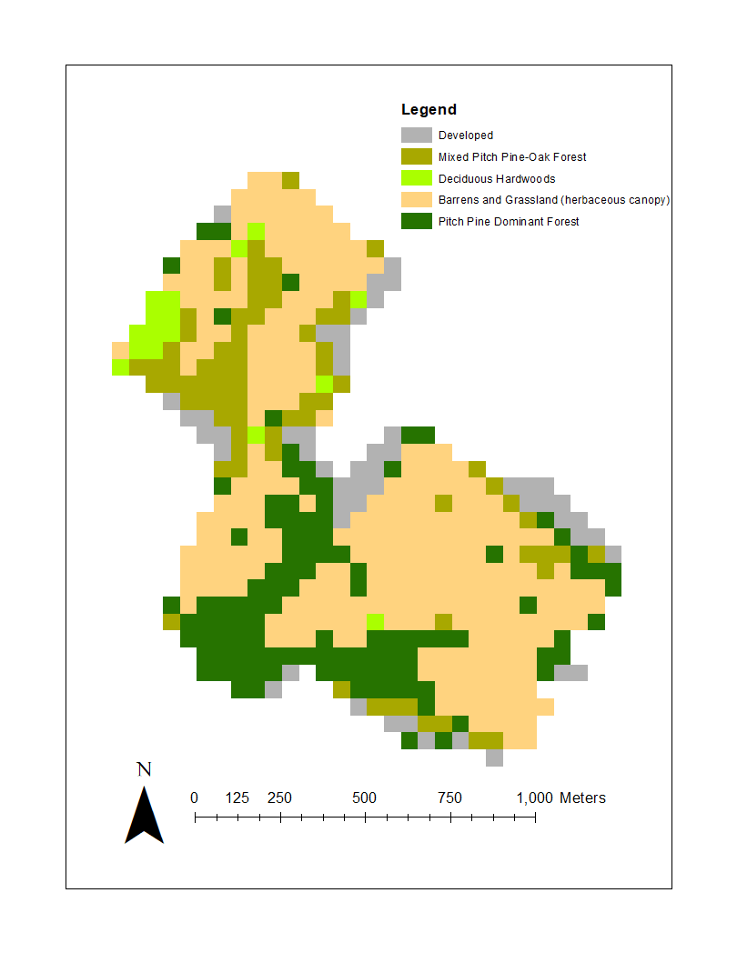
Poughkeepsie Natural Resource Inventory or research projects at the Collins Field
Station on Vassar Farm) and they are more likely the ones who will pursue GIS as a
career and/or go on to graduate school to study GIS or a GIS-related field.

eSpatiallyNewYork: Tell us something about Vassar GIS students/grads,
YouthMappers, and Society for Conversation GIS

Curri: Hudson Valley Mappers is the Vassar-based chapter of YouthMappers, an
international organization supported by USAID. Two former students, one of whom now
works for USAID supporting YouthMappers, began the chapter in the Fall of 2018.
Students involved in HV Mappers are passionate about using GIS as a resource for
communities, both locally and around the world. The group coordinates local community
mapping events, usually involving some field data collection and partnering with one or
more local organizations, as well as organizing mapathons in which students participate
in Humanitarian OpenStreetMap Team (HOT) mapping projects

eSpatiallyNewYork: What was your geospatial roll and contribution with the City of
Poughkeepsie Natural Resource Inventory?

Curri: I mentored several student workers who assembled the maps created for the
report and online content and I ended up editing some sections of the report with Jen
Rubbo, Director of the Environmental, who led the project. Part of the it involved
inventorying and inspecting Ash trees for impacts by Emerald Ash Borer. I worked with
students and staff using previous tree inventory data by the City’s Shade Tree
Commission as the starting point, set up an ArcGIS Collector project for the field data
collection, and helped organize the information into a public-facing web map. That data
was used by the City to identify trees that presented a potential hazard and remove
them. There’s a short video describing that part of the project on the City’s website.

eSpatiallyNewYork: You worked at Dutchess County Cornell Cooperative Extension
between 2007-2015. What is your involvement there today?

Curri: I was recently asked to serve on an advisory committee for Dutchess County Cornell Cooperative Extension’s pending update of the County’s Natural Resource
Inventory. I worked on the last revision several years ago while at CCEDC, which was
an update of the previous version conducted in 1985 by the County’s Environmental
Management Council. A former intern and a volunteer I mentored there both went on to
graduate school and made careers for themselves in GIS – one is now with the NYS
GIS Program Office and the other is on staff at CCEDC.

eSpatiallyNewYork: You currently serve as Chair of the Town of Lloyd Environmental
Conservation Committee. What’s your sense of the understanding and acceptance of
GIS concepts by citizen and community groups at this level in the Hudson River Valley?

Curri: Though I may not be totally sure, but I think most citizen and community groups
in the Hudson Valley – at least any that have an interest in environmental conservation,
planning, or community development, or anyone volunteering for a town committee or
board – have some sense of what GIS is and that it has value. But there is a lack of
capacity available to citizen and community groups, and consultants like me cost
money, and budgets are limited, so I think exposure to GIS and understanding how it is
or could be useful to them is still limited. Lloyd is one of few towns in the Hudson Valley
with some in-house capability, which predates my involvement.

eSpatiallyNewYork: Some of your community outreach work and involvement has led
to having the DEC Hudson River Estuary Program support an intern on one of their
funded projects. Tell us about how that developed.

Curri: A former student should get some credit for this. While we were finishing up the
Poughkeepsie NRI, she was taking the web mapping class, which is a half-semester
class taught occasionally taught by Prof. Mary Ann Cunningham. Mary Ann connected
her with us, and for her class project the student published the NRI layers to ArcGIS
Online and assembled them in nested web apps to combine functionality. Volunteers
working on NRI’s in two other Hudson Valley towns, Union Vale and Gardiner, saw the
Poughkeepsie online map and wanted one of their own. Interested interns came forwardand used the Poughkeepsie NRI map as a template to assemble those. Based on thesuccess of these, the DEC Hudson River Estuary Program then contacted me to inquireabout assembling maps for the Town of Gardiner’s Community Preservation Plan
(CPP). We found an interested student but it ended up being more simple for PVE to
assume the contract and hire the student. He and I are working on this project now.

eSpatiallyNewYork: What’s been your involvement in statewide GIS activities?

Curri: I’ve been a member of the NYS GIS Association for a few years, but not very
active.I used to attend NEARC regularly before my partner and I started a family five years ago. About two or three years ago, some folks from a few land trusts in the
Hudson Valley started up a local chapter of the Society for Conservation GIS. I have
missed only one or two of these meetings since then. It’s a great group of people and I’dlike to be more involved – after this semester is over!

eSpatiallyNewYork: Have a particular GIS project you worked on or produced that
would like to highlight or brag about just a bit?

I think I’ve already done some of that here, but I’ll mention getting to work with Vassar
Professor Emeritus Dan Peck on the maps for his book, Thomas Cole’s Refrain.

There’s some work for litigation projects at PVE I’d like to highlight but not permitted top
do so. Most of my projects I don’t really consider “produced” by me, as I am often
working with a subject matter expert, a geologist, a professor, or enthusiastic student, a
client, or community partner who’s more or less guiding the project, and I’m just figuring
out what geospatial product or tool fits their needs.

Contact:

Neil Curri, GISP
GIS Analyst, PVE, LLC
Vassar College Academic Computing Consultant
necurri@vassar.edu | 845-437-7708 | 845-664-2100 (mobile)

Hub2Hub: Sharing and Promoting the Geospatial Message

Publishing spatial data content has proven to be great outreach in terms of providing transparency and exposure for many government GIS programs – including here at Westchester County.  Increasingly much easier for geospatial organizations to do courtesy of powerful server technology allowing these same agencies to easily spin together data services based on common thematic features such as environmental, planimetric, business, demographics, cultural, parcels, and aerial photography to name only a few.  Though the data service environment is better understood and leveraged by a specific user community knowing what type of spatial content to look for, there remains even a larger community of geospatial users which navigate data portals to download just individual data sets.  Looking for that individual shapefile, KML, or .dwg file for their own individual project.

And even with all of this good geospatial content available, many publishing organizations – particularly government – struggle with building educational outreach programs for the larger GIS user community.  Tailored programs for users in community and advocacy groups, nonprofits, and even the business sector instructing how to effectively use and leverage our data.  Government GIS programs often do not have the resources or the business model to deliver these types of services outside of their organization.

Enter the emerging roll of “service” Hubs which specialize in leveraging government open data  in ways government programs normally cannot offer. Some are nonprofit in nature or affiliated with academic institutions.  Others, like OpenHub based in the lower Hudson Valley, is a for-profit venture.  The common theme among them is a window offering a wide range of engaging programs increasingly based on government data sets featuring hackathons, workshops and training programs,  application tools, and offering  business tech “round table-type” discussions.  While open source software such as OpenStreetMap, QGIS, Python, and R are commonly used to support their missions (and thus, the easy and affordable entry point for new users), one can see the use of ArcGIS Online and CARTO being offered as well.  Effectively expanding the use and understanding of geospatial concepts and bringing technology to the people.

Third Party “Hubs”

I’ve referenced and written before on the great work of BetaNYC serving in this space.  Particularly with regard to extending content of NYC OpenData  through their numerous programs including the flagship NYC School of Data conference.  While New York City does an incredible job in promoting and maintaining city government’s open data catalog itself, BetaNYC extends the effort by building an entire framework of putting the data into the hands of residents on the streets.

This BetaNYC viewing applications enables user to navigate the numerous political, administrative, and operational districts across New York City

Early in this space in the metro NYC area was the work of Steve Romalewski who started providing mapping services to the nonprofit sector as part of the Community Mapping Assistance Project (CMAP) which at the time was affiliated with New York Public Interest Research Group (NYPIRG).  Since 2006 he has been affiliated with the CUNY Mapping Service as part of the Center for Urban Research, Graduate Center at City University of New York (CUNY).

The Long Island Index was an early and very visible project that the CUNY Mapping helped create.  Another effort affiliated with the Center is the NYC Labor Market Information Service uses federal business and labor data sets.  Be sure to check out their Career Maps infographics and reports.  Similar academic efforts in the city exist at the Spatial Analysis and Visualization Initiative (SAVI) at Pratt Institute and the Center for Spatial Research at Columbia University.

Though originally developed at CMAP, the CUNY Mapping Service now hosts OASIS which is one of the most comprehensive mapping and viewing application covering the New York City footprint. Dozens of government generated datasets are made available in the viewer.

While the OpenHub is only beginning to jump into the geospatial space, its Founder Yulia Ovchinnikova will be highlighting the Westchester County GeoHub as part of the 2021 HV TechFest Conference as an example of open government and open-source data sharing to promote building communities. OpenHub will also be using content from the county’s GeoHub as part of a course project during a current online Data Analytics Bootcamp.  As regional technology and economic development is an important focus to OpenHub’s mission and purpose, our discussion started by focusing on a new web map being published which highlights the emerging BioSciences Ecosystem community in Westchester County.  The County is home to the largest biosciences cluster in New York State, boasting 8,000 jobs and 20 percent of the State’s total biosciences employment. The cluster comprises academic institutes doing basic research, R&D and clinical stage startups, large manufacturers and supply chain participants. OpenHub offers a mixture of both free and fee-based online programs including coding clubs, meetups, programming, and specific events for small businesses and startups. OpenHub is an open ecosystem resource center committed to building a tech-sector in the Hudson Valley and beyond

Government open data and economic development. BioScience business location X,Ys are available for download via ArcGIS Online.

MANY organizations leverage government generated geospatial data to support their own business needs and/or to champion a host of civic needs and issues.  In just one area, such as environmental justice (EJ), a Google search located a document published by the SeaGrant program at SUNY Stony Brook which identifies the numerous individual agencies (largely government and nonprofit) engaged in providing “Environmental Justice Mapping Tools for New York State Communities”.   Child care, social services, public safety, public transportation, sustainability, climate change, and civic issues only scratch the surface of the spaces where advocacy groups are involved in using government geospatial content for the larger public good.

Summary

What differentiates the groups itemized above are that they are more full service, a la carte organizations offering a wider range of products and services.  Staffing and resources to turn government data content into meaningful deliverables such as workshops (online and in-person), hackathon-type events, community events,  training courses, and even bringing the data to civic leaders and administrators in ways which is simply not possible by government publishing agencies.  Such outreach is often very targeted making the data more meaningful and ending up in the hands of those who understand its content the most.  Viewing and using the data at the “micro” as opposed to the “macro” or a larger geographic footprint.  Local is better.

While technically not all “hubs” in name, these groups continue to illustrate the growing benefit of how organizations are adding value and exposure to the government data assets.  In many scenarios, building partnerships with these types of service organizations can be of great value to government publishing agencies.


Cash Savings: Affordable Geospatial Bachelor Degrees in New York State

While putting together my last article (GeoSpatial Student Spotlight), I came across a related article that’s worth a quick mention.  In the same academic space, it is an article by the online site Affordable Schools which is essentially a clearinghouse of sorts, inventorying and ranking schools  on a wide range of academic programs and professional fields on three core metrics:   Cost (affordability), class size (student-to-faculty ratio) and student success (graduation rate).  The report is entitled: “30 Best Affordable Geographic Information Science and Cartography Degree Programs (Bachelor’s) 2020”.

Albeit not in the same conversation as the more esteemed college ranking reports by Forbes, U.S. News and Word Report, or Niche, the Affordable Schools evaluation approach is relatively simple in how data is collected/evaluated and from what sources.  And yes, the bottom line focusing on affordability.  Best yet, it paints an outstanding picture of affordable traditional geographic information science/system (GIS) bachelor degrees in New York State when compared against the field across the United States.  Interesting results with four New York State schools in the top thirty with three in the top ten.  All are SUNY schools which speaks volumes to the affordability of higher education opportunities in this space across the Empire State.

Points for ranking the schools and their affiliated geographic information science/system programs were allocated in the following manner:

Those schools in New York State identified in the “30 Best Affordable Geographic Information Science and Cartography Degree Programs” (2020) include:

#30      Farmingdale State College
Farmingdale, NY 11735
Points:  6
#6        SUNY Cortland
Cortland, NY  13045
Points:  7
#3        University of Buffalo
Buffalo, NY  14260
Points:  8
#2        SUNY College at Potsdam
Potsdam, NY  13676
Points:  8

Potsdam and Buffalo ending up with the same point total but Potsdam most likely getting the slight higher ranking due to a slightly lower in-state tuition fee and Buffalo having a much higher out-of-state tuition price tag.  While University of Buffalo has been a mainstay on the Empire State higher education geographic information science/system stage for over three decades – the Farmingdale, Cortland and Potsdam programs are of more recent development. The University of Buffalo is one of the three original universities associated with the The National Center for Geographic Information and Analysis (NCGIA) formed in 1988.

Again, the caveat here is that this is 2020 data and for traditional, on-campus bachelor degree programs – which almost seems like an oxymoron in July 2021.  So while there may be some resemblance to a “return to campus” in the years ahead, the COVID pandemic has most probably changed the delivery of higher education classes and programs to some extent for good.  And with it, creating more educational opportunities, all levels,  in the online environment.  For 2020 affordable online bachelor geospatial programs, there is the OnlineU website though only with ten schools identified and none within New York State.  Though the good news with online opportunities is that there is a growing acceptance and presence across the Empire State in certificate programs and perhaps even the availability of an online Associate Degree in the future.  Such discussion will be the subject of a future eSpatiallyNewYork blog post.

Of course the programs itemized above are not the only schools in the state which offer bachelor programs in geography information science/systems, geography, and  related technologies. Four-year, masters and PhD programs are available at universities in the New York City as well as other SUNY campuses which can be identified by using the SUNY “Find Your Major” search widget here.

Spread the news.


Geospatial Student Spotlight: Caitlyn Jeri Linehan

Academic Institution:

Lehman College, City University of New York (CUNY)                              Bronx, NY
Department of Earth, Environmental, and Geospatial Sciences
MSc Geographic Information Science  (June 2021)

Trinity College                                                                                            Hartford, CT
B.S. Environmental Science  (May 2019)

Research Focus:

Linehan’s graduate research focused on studying future urban sprawl in the metropolitan area of Nashville, Tennessee (Davidson County).  As part of this work, she applied the SLEUTH (Slope, Land cover, Exclusion, Urban growth, Transport and Hill shade) Model which utilizes several commonly accessible geospatial datasets including
USGS Shuttle Radar Topography Mission (SRTM), National Land Cover Database (NLCD), U.S. Census Bureau road files, and Digital Elevation Models.  Additional geospatial data was added from local sources.

Developed by Dr. Keith C. Clarke at UC-Santa Barbara, SLEUTH is categorized as a “cellular automata (CA) model” and is open source and available for download.   It models urban growth based on cells (5km x 5km, 30m x 30m, etc.) which support the geographic  unit of analysis.  The model suggests that changes in the geographic construct of any specific cell normally mimics and is a result of similar changes in neighboring cells.  Clarke was faculty at Hunter College in NYC 1982-1986.

Historical imagery and vector data of the datasets identified above of Davidson County for 2001, 2006, 2011, and 2016 were collected and used to calibrate the SLEUTH model to simulate urban growth for the period of 2017-2040. The urban area for 2016 was 119.81 square miles and from the SLEUTH model is said to increase to 121.90 square miles for 2040. The urbanization rate during the historical time period (2001-2016) is 11.11% but the SLEUTH model predicts a  much slower urbanization rate during the simulated time period (2017-2040) of 1.59%.  This study shows the SLEUTH model can be beneficial in modeling future urban growth but also suggests a need to model more accurately development within intra-urban areas as well as vertical urbanization within already densely urban regions.   Here is a great 10-minute YouTube presentation describing the study and for those interested in more detailed information, here is a copy of Linehan’s thesis.

While the population of Nashville and Davidson County is expected to grow over the next 20 years, most of the growth is anticipated in already developed areas minimizing urban sprawl.

Selected Additional Geospatial Projects:

New Yorkers for Parks

As an intern for the New Yorkers for Parks, Linehan created Open Space Profiles on parks and open space citywide, broken down by each NYC community board district. From open space quality and access to demographic and health information, the Profiles offer a summary for all 59 NYC community districts. This product enables elected officials, candidates, and community groups alike can use to better understand and convey open space issues in their communities.

Many interesting facts are presented in the profiles. For example, 33% of New Yorkers do not have a park within a five minute walk and 48 of 59 districts have less than 10 percent of city-owned parkland within their district. More data can be found here.

Best Places to Breath in New York City

That map for the land use regression having to do with PM2.5 (particulate matter) concentrations in NYC was done as a class assignment. The purpose of this map was that there is air monitors all over NYC. Using data air monitoring stations across New York City, Linehan used an ordinary least squares regression to test the associations between the dependent variable PM2.5 (particulate matter) measurements and the independent variables (major truck routes and population density). The result from this regression was estimated PM2.5 data which was used to interpolate a surface which shows the estimated PM2.5 values across NYC. The map in the lower right shows that the suggested and safe PM2.5 values is 12 micrograms per cubic meter according to the U.S. National Ambient Air Quality Standards. Only isolated locations in south Brooklyn and Queens and a few areas in Staten Island actually have an acceptable PM2.5 value according to this study.  Data used in the study was from U.S. EPA, New York State DOT and U.S.Census.

With the focus on using data from citywide air monitoring stations, Linehan’s project identified only a select number of areas across the city that met acceptable air quality standards.  This poster can be downloaded here.

Accessibility and Connectivity of Bike Paths in the Bronx, New York

Another one of Linehan’s class projects focused on applying a network analysis on the accessibility of a low stress bike network in the Bronx to access select facilities which promote well being such as parks, recreation centers, and libraries.  It is well established people that engage in physical activity can greatly reduce the risk of different diseases as well as reducing stress and anxiety.  To this end, biking is a great form of physical activity that provides these benefits though a deterrent to urban biking in areas such as the Bronx, is a lack of a connected bike path.

Her findings, which are included in the poster below, finds that though only a small proportion of Bronx residents do not have access to a park entrance via a bike portal, it is estimated a disproportional percent (89%) do not have access to recreational centers and 53% lacking bike access to libraries.  Central to the analysis is applying “Level of Traffic Stress” (LTS) coefficients to each road segment.  A copy of the poster below can be downloaded here.

Safe and readily available bike networks are important factors in providing access to urban cultural and community facilities.  This poster can be downloaded here.

Summary:

The Lehman GISc Program emphasizes “real-world” applications of geotechnologies and geospatial analysis to solve problems and improve conditions focusing on New York City as a “living laboratory.”  The program continues to grow and providing trained and well educated graduates to organizations and governments across the metropolitan area.

Linehan will be continuing her graduate education by beginning her doctoral work at the University of California – Santa Barbara which was one of the original three universities associated with the The National Center for Geographic Information and Analysis (NCGIA).   Formed in 1988,  NCGIA also includes the University of  Buffalo and the University of Maine.

 Contact:

Caitlyn Jeri Linehan
Graduate Student
Lehman College, City University of New York (CUNY)
Department of Earth, Environmental, and Geospatial Sciences
CAITLYN.LINEHAN@lc.cuny.edu
CaitlynLinehan@ucsb.edu

Dr. Yuri Gorokhovich
Associate Professor
Lehman College, City University of New York (CUNY)
Department of Earth, Environmental, and Geospatial Sciences
yuri.gorokhovich@lehman.cuny.edu

Geospatial Student Spotlight: Christopher Plummer

Academic Institution:

The University at Albany, SUNY
Department of Geography and Planning
Pursuing M.S. in Biodiversity, Conservation, and Policy

B.S The College at Brockport, SUNY, Environmental Science and Biology

Research Focus:

Using drones to assess white-tailed deer abundance and habitat preference in the Albany Pine Bush Preserve

Plummer’s overall research goal was to use thermal imaging drones to perform aerial surveys of white tailed deer and associated drone technology to produce an up-to-date habitat assessment of the study area to assess both white-tailed deer abundance and associated habitats. Plummer’s research proposes drones:

  • Offer a faster and lower cost of aerial data capture
  • Can be flown with lower detection from wildlife
  • Can be equipped with thermal sensors to aid in wildlife detection
  • Offer high accuracy population data with robust statistical strength

Study Area and Background:

Located northwest of Albany, the Albany Pine Bush Preserve (APBP) is approximately 3,350 acres supporting a broad variety of habitats highly fragmented by roads developed areas.  Hunting, fishing and trapping are recreational activities that are carefully regulated in the preserve following relevant APBP and New York State Dept. of Environmental Conservation (NYSDEC)  rules and regulations.

Historically, the monitoring of whitetail deer (WTD) has been difficult to establish due to obtaining reliable abundance estimates as traditional survey methods are normally very work intensive and/or expensive.  In the past such estimates have been done within the preserve with spotlight surveys and camera trap surveys.

(Historically, obtaining reliable abundance estimates of white-tailed deer has been difficult to establish, with more traditional methods being work intensive and/or expensive, and having issues with imperfect deer detection. In the past such estimates have been done within the preserve with spotlight surveys and camera trap surveys. Plummer plans to use the findings from the previous work to help understand how the use of drones compares to the more traditional survey methods.

Unmanned Aerial Vehicles (UAV) technology, more commonly called drones, was chosen as a means to facilitate WTD data collection and analysis in the Preserve.  Specifically, DJI Mavic 2 Enterprise Dual was used for the thermal deer survey while other DJI drones (Phantom 4 and  Insprie 2) were used to help create the orthophoto map.  A MicaSense RedEdge 3 multispectral camera which was attached to one of the drones helped pick up additional reflectance characteristics of varying vegetation types.  This camera has 5 bands, with the two additional bands sensing red edge (~715 nm) and near infrared (~825nm) wavelengths.

Universal Ground Control Station (UGCS) and DJI Pilot software was used to develop flight plans over three distinct focus areas in the Preserve.  Multiple flights were made to acquire enough images with sufficient overlap.  Plummer used Agisoft photogrammetry software to generate orthophotos of the study areas.

ENVI software was used to generate a supervised canopy cover classification of the study area.  Plummer was able to classify the entire orthophoto with >95% accuracy into herbaceous/open canopy, deciduous canopy, coniferous canopy, bare ground/no canopy, and developed canopy.  ArcMap 10.6 was used in a variety of ways as well as R-Studio and Microsoft Excel for data analysis.

Three flight plans in Blueberry Hill East and West and the Kaikout Kill Barrens

The research team flew a total of 34 surveys between March 9th and May 22nd 2020 with all flights occurring within 1 hour of sunrise collecting over 950GB of imagery files.  A total of 405 deer were spotted and identified in 143 unique locations.

Silhouettes of five deer as seen through Plummer’s use of thermal imaging photography

Project Findings

Plummer’s initial calculated observed average density of 13 deer per sq. km is unlikely to be uniform over the entire Preserve due to varying  landscape dynamics and various habitat types. The abundance within their study area varied widely over time, which Plummer suggests  is explained by daily movements made by individual groups into the nearby residential areas.  With regards to habitats, deer were more frequently found in the following areas of the Preserve:  (1) areas of recent timber harvest, (2) Pitch Pine cover and in the pitch-pine scrub oak barrens, (3) areas with significant dune activity, and (4) close to the edge of Preserve boundaries. He believes this new method for assessing white-tailed deer abundance has high potential in the wildlife monitoring space and hopes  his findings about deer within the Preserve will help generate well informed deer management decisions.

Plummer generated a habitat classification map based on the percent of each canopy type within a 50m x 50m grid covering the entire study area. The Pitch Pine Dominant Forest habitat along the southern border of the Preserve was one of the areas with the highest WTD counts.

Actual WTD observed during any given survey varied over time. Over the near three month data collection period in early 2020, WTD observation counts ranged from 1 to 30

Summary

Plummer’s SUNY Albany graduate work suggests that thermal drones are a viable tool to assess WTD population dynamics and can generate reliable abundance estimates.  Drone deployment provides the ability to survey large geographic areas in a small amount of time and a cost effective manner.  Results show that deer use a variety of habitat types in the Preserve and numbers at any one location varies temporally.  A detailed video presentation Chris made outlining his work to the members of the APBP is available here on YouTube.

Post-graduate work, Plummer would welcome the opportunity to work for an agency such as U.S. Fish & Wildlife Service or NYSDEC Division of Fish and Wildlife. He’s not opposed to going back to school for a PhD but not anything immediately.  He is also very interested in public policy related to climate change and sustainability.

Contact:

Chris Plummer
Graduate Student
University of Albany
Geography and Planning
ccplummer@albany.edu

Dr. Alexander Buyantuev
Associate Professor
University at Albany
Geography and Planning
http://www.albany.edu/gp/Buyantuev.php

Google Earth in the Classrooms

Chromebooks, Google Classroom and Google Earth Together Provide a Framework for Teaching Geography and many other subjects in K-12

I actually started drafting an article on Google Earth in the classroom last fall but since then it’s been one thing or another pushing things to the back burner.  Mostly work priorities but then COVID-19 sent everything sideways.  Seemingly pointing us all in a new and uncharted direction.  A new and greater reliance on the internet as many of us found ourselves working remotely.

The remote work force in many of our extended families includes teachers of whom I now have even greater respect after watching what is involved in teaching remotely and online.  The lesson plans, prep work, surgically attached to the computer, and the seemingly endless hours of the encompassing interaction with students – and parents – well beyond the normal eight-hour work day.

In a roundabout way watching this teaching workflow unfold during the COVID lockdown brought me back to the Google Earth article.  Google’s presence in the classroom is ubiquitous built around Google Classroom which I can only imagine will grow immensely as remote K-12 education expands in the future.  Wrapped in with kabillons of lesson plans, templates, covering every education topic, discussion groups, forums, and blogs from around the world – everything built on top of Google technology.  Easily delivered and made available to the masses at all levels of the educational spectrum with the uber cheap and incredibly functional Google Chomebook.  (btw – using one as I type).   And easily accessible within this framework – and bringing me back to the beginning of this article – is the Google Earth product for use in the classroom.  It’s an incredible product to augment K-12 classroom teaching and not just for geography.

Continue reading

2018 Westchester GIS User Group Meeting

Westchester County GIS has been fortunate to build a broad and diverse community of GIS users and followers over the past two plus decades which is embodied at the our annual GIS User Group Meeting each May.  Similar to many first generation GIS government programs which were created in the late 1980s/early 1990s, most of the first decade worth of geospatial programs and applications Westchester County GIS developed were government focused.  But as geospatial technology grew at warp speed in industry and business and combining the development and availability of a high accuracy countywide Westchester County digital base map,  the visibility of the program quickly expanded.  Interest from public safety, nonprofit, academic and civic groups soon followed.   And not to minimize the importance of the continued political support the program has maintained over the past two decades at both the county and municipal level.   Illustrative of this year’s May 17th meeting held at Purchase College, nearly 170 representatives from  government, industry and business, utilities, academia, nonprofits,  community groups, and the military convened for the sharing of presentations, geospatial solutions, and best practices to move the countywide and regional geospatial agenda forward.

2018 Agenda

In years past there had always been an effort to keep the presentations and agenda diverse – a little bit of everything.   While this has generally served us well over the years, this was the first year we had a specific theme:  GIS for Resiliency and Sustainability.   This was in response to recent work our GIS program had completed in context of investigating potential impacts of projected sea level rise on county-owned assets as well as administrative changes in the Westchester County Executive  office as a result of the November 2017 elections.  In the process of bringing these two issues together and including the Office of Sustainability at Purchase College, we were able to add Westchester County Executive George Latimer and Purchase College President Thomas Schwarz to our agenda.  Both mentioned and acknowledged the importance and relevance of technology and geospatial in supporting the regional sustainability agenda.

Westchester County Executive George Latimer talking with 2018 User Group meeting attendees. He made reference to the use of geospatial technologies in confronting Climate Change issues.

2018 Speakers

Working with the theme of GIS for Resiliency and Sustainability, we were able to include two well recognized state government speakers in Mark Lowery, Climate Change Analyst with New York State Department of Environmental Conservation, and Amanda Stevens, Project Manager with New York State Energy Research and Development Authority (NYSERDA) Environmental Research Program.  With the County’s work in this space increasingly including nonprofit groups, representatives from both  Abundant Efficiency and the Westchester Community Foundation were also on the agenda.  In the mix were talks by SUEZ North American (water utility) and BetaNYC – an open data advocacy organization based in New York Ctiy.   Additionally, we continued to feature our ongoing relationship with the U.S. Military Academy at West Point with a noon presentation by Lieutenant Colonel Jared Ware.  Our afternoon session of Lightning Talks and panel discussion featured Sustainable Westchester and representatives from five local governments.

In the morning session, Amanda Stevens provides an overview on NYSERDA’s work and research efforts in the area of climate change – which includes programs in the Lower Hudson River region

Bringing it Together

Admittedly there is always a little luck in hosting conferences such as this and it only takes a day of bad weather for attendance to bottom out (been there).  Of course, nothing beats an agenda based on current and cutting-edge geospatial topics backed with recognized speakers, but there are a couple other factors worth noting that seem to help make all of this work for us, including the following:

All Things Local:    For all the benefits and advantages of the larger shows, localizing the day’s content and message for local/regional like-minded individuals goes a long way.  Geospatial business needs and problems – and often the solutions – are conceptually very similar.  Familiar faces with familiar issues.  The organic approach.

Affordability:   Offering such events at a discount, like free as in our model, makes the event more attractive to more people.   However,  if its free, it is easy to not show.  Nothing paid nothing lost. And we have the historical numbers to show as such.  Over the past six-seven years we’ve seen a 25%-30% no show rate from the actual number of pre-conference registration numbers.    That said, we’ve learned to factor this variable in the printing of conference materials and sizing break refreshments and lunch.  We’ve also learned over the years that other groups and professional societies we’ve tried to partner with in hosting the show may be hesitant to collaborate because they (other organizations) do not want to send a message to their memberships that meetings, and certainly ones that offer Professional Development Units (PDU), are available for free. The bottom line for us is that we continue to make the show free based on vendor fees and affordable food services from the venue location.  And besides, there is no capacity to collect money online and/or to deal with bank accounts.  What little money management needs we have are handled graciously through the college.  Getting pass the bouncer at the door for free works for us.

Vendor Interaction:  I can’t say enough about how important this is.  We put a lot effort into making sure our sponsors have ample time for interaction with the attendees. Information gathered by attendees in the exhibitor area only adds to the overall value of their day.  Food and refreshments are close by so everything (and everybody) is in reaching distance of the vendors.  We also have vendor “Vendor Bingo Card” game that encourages attendees to visit each vendor table to qualify for a prize drawing.  Pretty nice incentive as this year the prize was a vendor donated iPad.   All sponsoring vendors are entitled to 5-minute “Vendor Spotlight” presentation over the course of the day.  Without vendor support the day doesn’t happen so we make it worth their while.


Everything is nearby at the Westchester GIS User Group Meeting. Vendors, refreshments, and the main auditorium are all intertwined and close. Making the experience interactive and personal on many levels. It’s a win-win for everyone in attendance. Who are those folks in pink?

The Venue:   For the past seven years, Purchase College has graciously made their facilities available to us to host the show.  Prior to that we bounced around the County at other locations, but given our relationship with the faculty in the Environmental Studies Program this became a logical spot. Centrally located in mid-Westchester.  Easy access.

A naturally lighted vendor area, albeit small, adds to the personal “feel” of the show.  One of the main reasons we originally went to Purchase during the third week in May was that the Student Union cafeteria was still open we could make lunch “on your own”.  Avoiding all the overhead and cost of providing lunch.  We’ve since been able to work with campus caterers to provide us with an affordable lunch menu which is vendor sponsored.   This “grab lunch and go” format enables users to eat where and how they want –  attending special lunch time presentations, continued discussions with vendors, or simply going outside to eat on the campus plaza.  The entire agenda is plenary format held in a cathedral style 150-seat auditorium.    We once tried a concurrent sessions format but it just didn’t work and feel right so we went back to the basics.  Post-meeting training sessions have proven to be hit or miss.  Just seems that just come 3PM after a long day of presentations, networking, and interacting with vendors, most folks are running to the exits.  Or the no-host reception down the street.

One of the ironies – and downsides – of having the show on a college campus in mid-to-late May is that spring semester is already over and students have fled campus, though  there is normally a handful attending looking for summer or full-time work and passing out resumes.    But we clearly do not have the college student attendance that is seen at comparable conferences such as GIS-SIG.

Engage the Professions:  We make a significant outreach to the “aligned” professions including engineering, public works, surveying, police and fire departments, government administrators, the planning community and increasingly nonprofits.  I wish there was an easier entry point into the 41 school districts here in Westchester County – and particularly their uber large budget bus transportation systems – but we’ve never been able to find it.     We  focus our efforts to reach the professions with individuals and technical staff that use geospatial technology.  Day-to-day work flows that has geospatial intertwined –  but is not the only focus of their business day.  Truth be told, there simply aren’t a lot of individuals locally who only do GIS work during the course of their business day.  The carrot that we offer across the board – and the common denominator – is the geospatial content we publish from our program via our data warehouse or map services.

Summary

Declining government budgets and  travel restrictions positions the Annual Westchester GIS User Group meeting as the primarily, if not only, major GIS event many of our government attendees get to each year.   It enables us to craft a geospatial message in context of local needs and applications as illustrated in this year’s theme “GIS for Resiliency and Sustainability”.  And keeping in mind the importance of their support, the event provides a great framework for industry and business to showcase their product and services.  And none of it possible without the support of the great folks at Purchase College.

Cognizant of the many differences and capabilities within the regional GIS communities,  it is often difficult to host such events on a reoccurring basis.  Perhaps some of the elements of our event can be used in helping build capacity for creating similar events for other regional GIS user communities across the Empire State.


Geospatial Public Health Research in the Empire State

It was at the 2015 NYS GeoCon Conference in Albany that I saw only a portion of Dr. Tabassum Insaf’s presentation entitled “Lessons Learned in Small Area Spatial Analyses of Health Outcomes” which started an interest in the state of applied GIS/geospatial activity in medicine and health care across the Empire State.  Having yet to approach the topic as part of eSpatiallyNewYork and finding an almost complete absence of health sciences content at the exact same state GIS conference this past fall in Lake Placid, I decided to circle back to Dr. Insaf to see if I could begin to scratch the surface on the use of geospatial in the NYS  health sciences research communities.

The Albany Connection

After initiating my correspondence with Dr. Insaf, the use of geospatial technologies in academic health care research across the Empire State became apparent..  Given the presence of NYS Dept. of Health in Albany, research in this space at the SUNY Albany School of Public Health is an obvious location.  Further review of the subject matter identified similar research programs at other academic institutions including Columbia University, New York University, and CUNY.

Like several other New York State Department of Health (NYSDOH) Research Scientists, Dr. Insaf holds an appointment at the School of Public Health.  At NYSDOH, Dr. Insaf is the Acting Research Director at the Bureau of Environmental and Occupational Epidemiology.  Her research interests are in understanding the role of environmental, social and behavioral factors in health disparities. Her work encompasses longitudinal and multilevel data analysis, Geographic Information Systems (GIS) technology and spatial epidemiologic methods.

With regard to the shortage of health sciences presentations at New York State GIS conferences, Dr. Insaf suggests the issue may be threefold:  (1) While the use of geospatial technology is common in their work, results in this space are often not presented or used as maps or other visual aids. (2)  Health data is often confidential and locations cannot  be published, and  (3) there may be more due to a lack of awareness in the health community that there may be interest and audience for this type of work in the GIS community.

Illustrative research efforts of Dr. Insaf include:

Social Determinants of Health for Low Birth Weight (LBW)

This research utilizes a variety of NYS public health records with the intent of better understanding and identifying potential social determinants of low birth rates focusing on data from selected census tracts in the metropolitan areas of Buffalo, Rochester, Albany, and Westchester/Long Island.   Applying geoprocessing tools and analysis, research findings suggest that census tract-area proportions of LBW was highest in areas with larger Hispanic or Black populations and high smoking preferences.  Spatial Regression analysis was used to  predict prevalence of LBW based on these major social determinants to identify areas of high risk of LBW.

Predicted rates (%) for low birth weight prevalence based on a spatial error model that incorporates social determinants as race/ethnicity, prenatal care, smoking prevalence and maternal education.

It’s worth noting that her work in this space included collaborating work with Tom Talbot, now retired, who was an early champion of GIS technology in NYSDOH.

Health Impacts from Increased Temperatures Due to Climate Change

More recently Dr. Insaf has been working with several state agencies (bringing together New York State Department of Health, Florida Department of Health and New York City Department of Health) to develop indicators of localized climate trends, review and develop public health relevant heat warning messaging and develop local assessments of vulnerability to extreme heat for specific communities using remote sensing data from NASA satellites.

The team has worked with multiple stakeholders and collaborators including the CDC Environmental Public Health Tracking Network, State Climatologists, National Weather Service offices, NYS Department of Environmental Conservation, Office of Emergency Preparedness and local county health departments to develop climate information relevant to their mandates and jurisdictions.  Researchers  spatially linked satellite derived modeled data for air temperatures and heat index at a 12KM resolution with geocoded health outcome datasets (Hospitalization and Emergency Department visits for heat stress, renal disease and cardiovascular disease).  The team then estimates the risk of adverse health outcome for each 5-degree change in temperature and have also developed heat health profiles combining heat, health and vulnerability indicators for each county. The county profiles will be available soon as downloadable pdfs at the NYS Department of Health Climate, Weather and Health website.

The initial assessment of Climate in NYS that was the springboard for this more recent work is published here.  In an analysis of the U.S. Historical and Climatology network dataset for the 60 year period of 1948-2008 it was found that the most representative extreme weather indicators in NYS for warm weather are growing season length and warm nights. The most representative indicators during cold weather are a decline in cool days and ice days.  Most other temperature indicators are also consistent with the warming trend.    The precipitation indicators in the study report all point towards increasingly wet conditions over time.  The most representative indicators were total precipitation and the simple daily index.  Data also suggests the Great Lakes, Northern Plateau, Champlain Valley and Coastal New York regions may be particularly sensitive to changes in extreme climate events.

The map shows the predicted rates (in %) for low birth weight prevalence based on a spatial error model that incorporates such social determinants as race/ethnicity, prenatal care, smoking prevalence and maternal education.

Her team is currently using a spatially contiguous satellite derived dataset to build upon this work and to estimate health risks of heat exposures in rural and urban areas of New York. She is working with the National Weather Service offices to inform guidance on heat warning issuance in the area based on local thresholds.  The ongoing work is sponsored through a NASA ROSES (Research Opportunities in Space and Earth Sciences) grant. A great poster presentation on this work can be found here.

Estimating Health Care Access Times

Dr. Insaf has been focusing research on data from a newly established congenital heart defects (CHD) surveillance program funded by the Center for Disease Control (CDC).  Analysis uses geocoded data from surveillance datasets to determine patient access times to Cardiac Surgical Care facilities using the Google driving distance/time Application Programming Interface (API).  These driving time estimates are then compared against travel times from the same address using public transit (where available in more urbanized areas).   It is widely accepted that differences in travel distance to appropriate care among individuals with birth defects can have a significant impact on healthcare utilization, and it has been suggested that geographic barriers may play a role in cessation of care among those with CHDs.

Calculated drive times in minutes for congenital heart defects patients to Cardiac Surgical Care facilities in Westchester County and the Bronx.

Other Representative Statewide Efforts

Dr. Glen Johnson, Associate Professor in the Department of Environmental, Occupational and Geospatial Health Sciences at the City University of New York School of Public Health, focuses geospatial aspects of health, with particular application to environmental and community-level social determinants of health outcomes. Research in the Bronx  includes examining the relationship between walkable access to healthy food sources (HFS) and the risk of anemia in pregnancy.   After geocoding patient residences, street network distances were obtained for the closest healthy food sources, which were identified from multiple databases.  For lower-income patients, as indicated by Medicaid or lack of health insurance, those who lived less than 0.25 miles from a healthy food source were less likely to be anemic when compared to those who lived farther away.  Patients with commercial insurance showed no effect.  These results continue to help to understand how a nutritionally-mediated condition such as anemia during pregnancy can be affected by one’s built environment, while also highlighting the importance of conditioning on socioeconomic status for these types of studies.

The primary variable of concern in the Bronx study: The street network walking distance to a Healthy Food Source (HFS) for a pregnant woman.

Most recently he has been working with the Cornell University Cooperative Extension (CUCE) who implement multiple programs aimed at improving overall population health in communities throughout NYC.  Examples range from community-based educational programs in nutrition and parenting to 4-H STEM programs for children.  Keeping track of the “where, when and who” of many ongoing programs in the largest city in North America is challenging. Online GIS mapping has provided a partial solution to this management challenge.  The poster below was presented at the New York State Health Foundation conference last December.

Johnson’s work also appears as  “A Community Needs Index for Adolescent Pregnancy Prevention Program Planning: Application of Spatial Generalized Linear Mixed Models” in . Maternal and Child Health Journal.  He is a former biostatistician for the New York State Department of Health and a faculty member of the University at Albany School of Public Health.

Also at  CUNY  Dept. of Environmental, Occupational, and Geospatial Health Sciences is Dr.Andrew Maroko, Associate Professor. Past research involves the use of geospatial tools focusing on the health outcomes of (unhealthful) food-and-beverage advertising in subway stations  This research focused on the correlations between ad exposures and sugary-drink consumption, fruit-and-vegetable intake, and diabetes, hypertension, and high cholesterol rates. Subway-station ads for “less-healthful” items were located disproportionately in areas home to vulnerable populations facing diet and diet-related-health challenges. The fact that uneven ad placement did not relate to total rider counts suggests ads were not directed at the largest possible audiences but rather targeted to specific groups.

Ad placement did not relate to the number of riders entering at stations. Instead, exposure to food-or-beverage ads generally, and to “less-healthful” ads particularly (specifically ads in Spanish, directed at youth, and/or featuring minorities), was directly correlated with poverty, lower high-school graduation rates, higher percentages of Hispanics, and/or higher percentages of children in surrounding residential areas.

Other Maroko NYS geospatial-based research work includes “Integrating Social Determinants of Health With Treatment and Prevention: A New Tool to Assess Local Area Deprivation” and “Direct observation of neighborhood stressors and environmental justice in the South Bronx, New York City”.

Dr. Jessica Athens at New York University School of Medicine, Department of Public Health, is part of the Health Geographics Research Initiative (Health GIS).   One of her primary focuses at the present is City Health Dashboard presents data on health outcomes and the upstream determinants of health for 500 Cities across the U.S.  Her team produced a pilot version with four cities which can viewed at www.cityhealthdashboard.com. Starting on May 15, the site will include data for 500 cities will be available at the same URL.

Dr. Athen’s other work includes the NYC Health Atlas which is sponsored by the New York Community Trust. The application provides direct service providers and public health researchers easy access to data needed for program planning, funding requests, and evaluation.

Also in the region at Columbia University, Department of Psychiatry, Division of Child and Adolescent Psychiatry, Drs. Christina Hoven, George Musa and Lupo Geronazzo-Alman are working on several projects using geospatial analyses to understand the effects of neighborhood quality, safety and socioeconomic status on psychopathology.

Summary

The combination of  world renown medical research facilities and the growing use geospatial technologies at  these organizations is an evolving environment the New York State GIS community should take advantage of and nurture.   As we find ourselves amidst major public health challenges impacting our communities from issues such as the growing influence of Climate Change, the spread of infectious diseases, and the ubiquitous opiod crisis among others, the use of geospatial tools in collaboration with the health care research community will bode well for increasing the visibility of the profession across the Empire State.