Systems Development Group (SDG) provides real property, imaging and GIS-centric software and professional services to government, education and private sector companies. The Company provides clients with the appropriate technologies to cost effectively improve tax payer services while reducing operational costs. Clients achieve operational efficiencies with SDG’s blend of expertise in assessment, imaging, GIS and software administration tools and professional services. SDG currently collaborates with state, county and local government agencies.
Location: 44 Trenton Road, Utica, New York 13502.
Website: www.sdgnys.com
Email: info@sdgnys.com
Phone: (315) 798-1328
Employees: 8
Established: 1991
Flagship Product: Image Mate Online (IMO) Real Property Web Portal
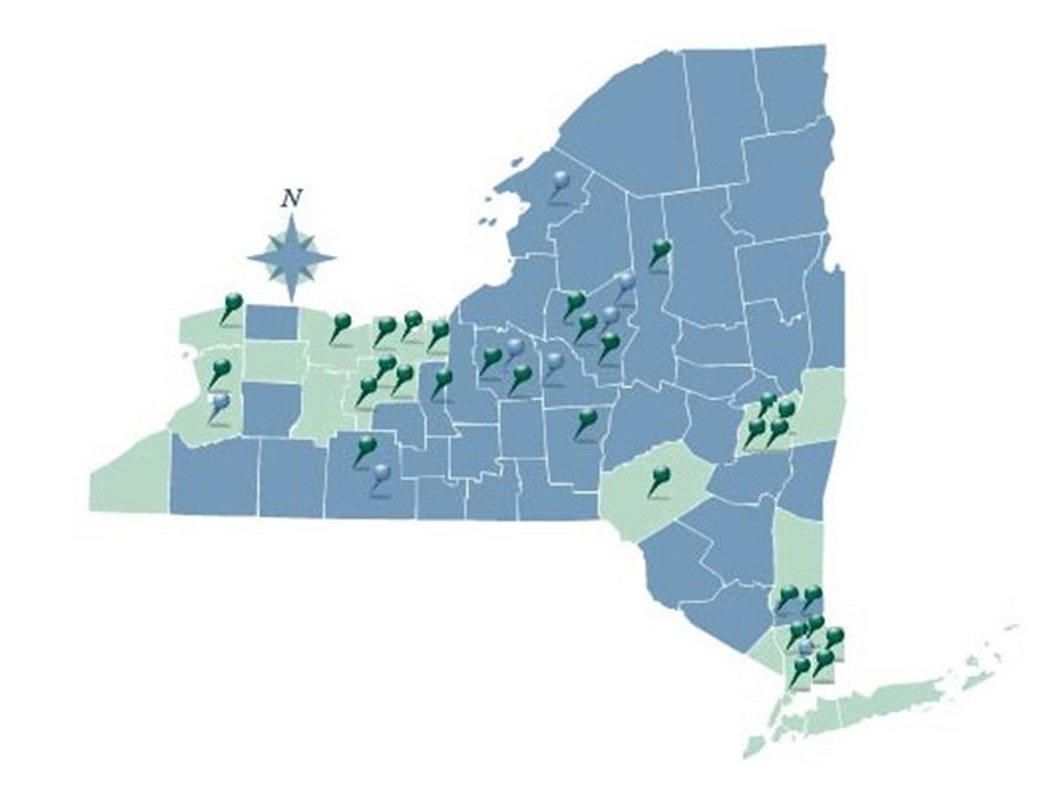
The New York State SDG IMO coverage area. Full County services are rendered in blue. Individual City or Town services are denoted by pushpins.
Brief History
In the New York State Real Property System ( RPS V3) 1990’s era, NYS challenged SDG by noting it was technologically impossible to display photos during a live RPS V3 session. SDG knew otherwise from similar projects performed for their parent company (Lanier Business Systems). Code being used to add imaging support to hospital applications was leveraged to build an initial application saving the Towns of Whitestown and New Hartford over $50,000 of previously ear-marked monies for Tyler-CLT Landisc street level imaging projects.
As SDG systems engineers and developers grew more familiar with assessment administration, opportunities arose to assist assessors with the development of line of business valuation software utilities including the Assessment Sales Analysis Program (ASAP) search engine. A combination of these software tools contributed to the successful NYS Office of Real Property Tax Services (ORPTS) RPSV4 launch.
RPSV4 was originally developed as a client server – “thick” desktop application. However, within a few short years, the internet and web application (browser) paradigm entered the software mainstream. The web quickly became a natural conduit to share real property information with the public and between Government departments and agencies. The next “organic” step forward for SDG was the development of a web portal for real property and assessment information – Image Mate Online (IMO).
IMO quickly gained popularity with NYS Counties and local municipalities throughout the early 2000’s. The State Real Property Tax Administration Technology Improvement Grant Program (RPTATIP) Grant program in 2006 and 2007 helped open the door for many additional County Real Property and Assessment Departments to deploy IMO portals. A large percentage of RPTATIP grant projects included IMO due largely to:
-
- Return on Investment (ROI) – The City of Yonkers experienced a 70% reduction in Assessment Office foot and telephone traffic within their first year of IMO operations.
-
- Extensibility – Ease of building upon the IMO portal to create “one stop shops” for comprehensive parcel related information.
-
- Tight bindings with New York State Real Property and Assessment rules and best practices.
-
- Strategic partnerships, projects and connectivity with “best in class” players including Pictometry, Apex, ESRI, Google, VHB, TerraGo and Sewall
-
- Performance and scalability – The Onondaga IMO site performs over 2 million parcel searches a year. At 20% the size, nearby Seneca County – over 80,000 searches annually.
-
- Outpost extends IMO and live RPS data collection services to the field as a low-cost tablet mobile sister service.