Geospatial Student Spotlight: Matthew Ward

Academic Institution:

Hunter College                                                          New York City
Department of Geography and Environmental Science
M.S. Geoinformatics (June 2021)

Virginia Tech                                                             Blacksburg, VA
School of Public and International Affairs
B.S. Environmental Policy and Planning   (May 2010)

Research Focus:

Ward’s graduate research at Hunter College focuses on the expanding use of Augmented Reality (AR) in the geospatial disciplines  with a  particular  interest  in  supporting civic  and public engagment.   AR is an interactive experience of the real-world environment where the objects that reside in the real world are enhanced by computer-generated content and perceptual information.   His research inspired by spatial AR research and development work at companies such as Google and  ESRI.

Ward’s work was recently highlighted and included  in the 2022 NYC OpenData  Week which included  augmenting street level imagery with the NYC PLUTO database which offers over 70 data variables at the tax parcel level.  Built on the WebXR standard, the web app leverages the THREE.js graphics library with files and front-end hosted on Github and the data on a Heroku  Postgres cloud platform.  The code repository and web app is available on Github. A short demo of the application can be seen here.

Cubes represent PLUTO centroids along the street face.   The magenta cube is the one currently selected by the user and provides current PLUTO information of the selected parcel in the upper left hand corner of the screen.  Cyan cubes represent other available PLUTO centroids for query. 

Ward’s smart phone app is now available (iOS and Android) here for entire NYC footprint.    Additional documentation and instructions are available on his GitHub repository 

Selected Additional Geospatial Projects

Gerrymandering Web Map

Ward performed a series of analyses on the proposed plans by the New York State Independent Redistricting Commission (NYRIC) based on data related to the 2020 census.  Because the Commission couldn’t agree on a single draft plan, the bipartisan members drafted two plans.  Two of the analyses are shown below (References to the “Names” (Republican)”vs “Addresses” (Democrat) Plans are from the New York State Senate District plans submitted by the NYIRC.

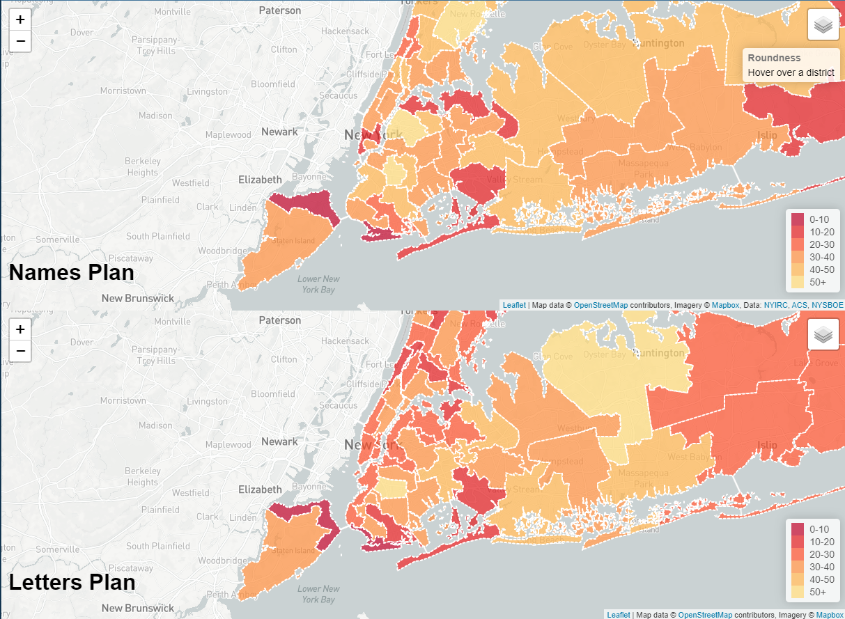
The image above (from a web map) is a test of “roundness” (aka the Roeck test [1961]).   In general, rounder districts will have a higher Roeck score and oddly shaped or districts that are wider or longer (darker shaped districts) will receive lower scores. Although not a perfect assessment of gerrymandering, the Roeck test offers good comparison between district shapes. 

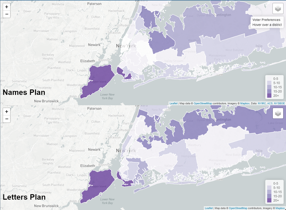
Another test done by Ward was comparing the average voter party tilt of a district to its neighboring districts (darker purple districts are more unlike their neighbors).  Metro NYC shows what could be considered large areas of voter homogeneity.

An map of an additional analysis is included with Ward’s paper (available here) summarizing this research work and findings.  The third review looked at identifying those proposed senate districts which had at least 30% minority group population (African-American, Asian, and Hispanic/Latino populations were used). Such districts are almost entirely located in New York City, with some inclusion of parts of Nassau county.  The research paper includes a comprehensive list of all data used in the gerrymandering analysis. A “live”  interactive version of the web mapping app can be accessed here.  The three different analysis for each plan (Names and Letters) can be viewed by clicking the layers button in the upper right hand corner of the viewing window.  (Designed for desktop viewers not smartphones.)

 Crime Modeling Across NYC

Ward’s graduate coursework also included developing a crime view modeling viewer (below) based on NYC OpenData reported crimes for 2019. Selected violent crime types were analyzed.  He developed an even square grid to cover the citywide footprint so as to render the spatio-temporal nature of the data.   Crimes that occur are tracked in space and time within those squares.  Data is associated with corresponding police precinct building addresses (how the data is made available through OpenData – not necessarily the exact crime location).

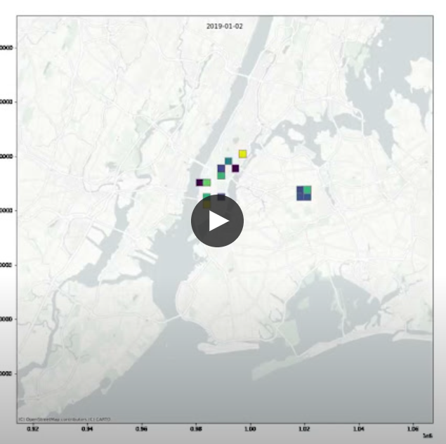
The data is for all of 2019 but each day of the model (365 days total) is rendering the three weeks of crime leading up to that day to predict ‘likelihood’ of crime going forward. Darker purple is an application “indicator” of where more violent crimes may occur based on the historical data.  Yellow grids meaning less likely than purple.  No color means no spatio-temporal connections in crimes or no crimes.  Click here to run the video.

Summary:

The Hunter College Masters in Geoinformatics (MSGEOi) focuses on the growing demand for emerging professionals  trained in the collection, organization, analysis, and dissemination of geospatial data.  Matthew Ward’s graduate work is illustrative of this as it intersects developing analytical methods and visualizations of large geospatial datasets. 

After school, Ward is interested in applying his work and research in the public or government space.  “I see the great power of combining open source technologies and open data portals for empowering local users with AR technology, he notes.  “For example, there are so many types of uses in helping the public visualize utilities and the public infrastructure or in environmental applications.”  

Augmented reality is no doubt a rapidly expanding and growing technology in the geospatial arena.

Contact:

Matthew Ward
Graduate Student
Hunter College, City University of New York (CUNY)
Department of Geography and Environmental Science
MATTHEW.WARD14@myhunter.cuny.edu

Dr. Sean Ahearn
Professor & Director, Center for Advanced Research of Spatial Information (CARSI)
Department of Geography and Environmental Science
sahearn@hunter.cuny.edu

Geospatial Student Spotlight: Caitlyn Jeri Linehan

Academic Institution:

Lehman College, City University of New York (CUNY)                              Bronx, NY
Department of Earth, Environmental, and Geospatial Sciences
MSc Geographic Information Science  (June 2021)

Trinity College                                                                                            Hartford, CT
B.S. Environmental Science  (May 2019)

Research Focus:

Linehan’s graduate research focused on studying future urban sprawl in the metropolitan area of Nashville, Tennessee (Davidson County).  As part of this work, she applied the SLEUTH (Slope, Land cover, Exclusion, Urban growth, Transport and Hill shade) Model which utilizes several commonly accessible geospatial datasets including
USGS Shuttle Radar Topography Mission (SRTM), National Land Cover Database (NLCD), U.S. Census Bureau road files, and Digital Elevation Models.  Additional geospatial data was added from local sources.

Developed by Dr. Keith C. Clarke at UC-Santa Barbara, SLEUTH is categorized as a “cellular automata (CA) model” and is open source and available for download.   It models urban growth based on cells (5km x 5km, 30m x 30m, etc.) which support the geographic  unit of analysis.  The model suggests that changes in the geographic construct of any specific cell normally mimics and is a result of similar changes in neighboring cells.  Clarke was faculty at Hunter College in NYC 1982-1986.

Historical imagery and vector data of the datasets identified above of Davidson County for 2001, 2006, 2011, and 2016 were collected and used to calibrate the SLEUTH model to simulate urban growth for the period of 2017-2040. The urban area for 2016 was 119.81 square miles and from the SLEUTH model is said to increase to 121.90 square miles for 2040. The urbanization rate during the historical time period (2001-2016) is 11.11% but the SLEUTH model predicts a  much slower urbanization rate during the simulated time period (2017-2040) of 1.59%.  This study shows the SLEUTH model can be beneficial in modeling future urban growth but also suggests a need to model more accurately development within intra-urban areas as well as vertical urbanization within already densely urban regions.   Here is a great 10-minute YouTube presentation describing the study and for those interested in more detailed information, here is a copy of Linehan’s thesis.

While the population of Nashville and Davidson County is expected to grow over the next 20 years, most of the growth is anticipated in already developed areas minimizing urban sprawl.

Selected Additional Geospatial Projects:

New Yorkers for Parks

As an intern for the New Yorkers for Parks, Linehan created Open Space Profiles on parks and open space citywide, broken down by each NYC community board district. From open space quality and access to demographic and health information, the Profiles offer a summary for all 59 NYC community districts. This product enables elected officials, candidates, and community groups alike can use to better understand and convey open space issues in their communities.

Many interesting facts are presented in the profiles. For example, 33% of New Yorkers do not have a park within a five minute walk and 48 of 59 districts have less than 10 percent of city-owned parkland within their district. More data can be found here.

Best Places to Breath in New York City

That map for the land use regression having to do with PM2.5 (particulate matter) concentrations in NYC was done as a class assignment. The purpose of this map was that there is air monitors all over NYC. Using data air monitoring stations across New York City, Linehan used an ordinary least squares regression to test the associations between the dependent variable PM2.5 (particulate matter) measurements and the independent variables (major truck routes and population density). The result from this regression was estimated PM2.5 data which was used to interpolate a surface which shows the estimated PM2.5 values across NYC. The map in the lower right shows that the suggested and safe PM2.5 values is 12 micrograms per cubic meter according to the U.S. National Ambient Air Quality Standards. Only isolated locations in south Brooklyn and Queens and a few areas in Staten Island actually have an acceptable PM2.5 value according to this study.  Data used in the study was from U.S. EPA, New York State DOT and U.S.Census.

With the focus on using data from citywide air monitoring stations, Linehan’s project identified only a select number of areas across the city that met acceptable air quality standards.  This poster can be downloaded here.

Accessibility and Connectivity of Bike Paths in the Bronx, New York

Another one of Linehan’s class projects focused on applying a network analysis on the accessibility of a low stress bike network in the Bronx to access select facilities which promote well being such as parks, recreation centers, and libraries.  It is well established people that engage in physical activity can greatly reduce the risk of different diseases as well as reducing stress and anxiety.  To this end, biking is a great form of physical activity that provides these benefits though a deterrent to urban biking in areas such as the Bronx, is a lack of a connected bike path.

Her findings, which are included in the poster below, finds that though only a small proportion of Bronx residents do not have access to a park entrance via a bike portal, it is estimated a disproportional percent (89%) do not have access to recreational centers and 53% lacking bike access to libraries.  Central to the analysis is applying “Level of Traffic Stress” (LTS) coefficients to each road segment.  A copy of the poster below can be downloaded here.

Safe and readily available bike networks are important factors in providing access to urban cultural and community facilities.  This poster can be downloaded here.

Summary:

The Lehman GISc Program emphasizes “real-world” applications of geotechnologies and geospatial analysis to solve problems and improve conditions focusing on New York City as a “living laboratory.”  The program continues to grow and providing trained and well educated graduates to organizations and governments across the metropolitan area.

Linehan will be continuing her graduate education by beginning her doctoral work at the University of California – Santa Barbara which was one of the original three universities associated with the The National Center for Geographic Information and Analysis (NCGIA).   Formed in 1988,  NCGIA also includes the University of  Buffalo and the University of Maine.

 Contact:

Caitlyn Jeri Linehan
Graduate Student
Lehman College, City University of New York (CUNY)
Department of Earth, Environmental, and Geospatial Sciences
CAITLYN.LINEHAN@lc.cuny.edu
CaitlynLinehan@ucsb.edu

Dr. Yuri Gorokhovich
Associate Professor
Lehman College, City University of New York (CUNY)
Department of Earth, Environmental, and Geospatial Sciences
yuri.gorokhovich@lehman.cuny.edu

Geography as a Factor in Accessing Educational and Human Services

Focus on SUNY Campuses and NYS Correctional Facilities

In recent years I had a close college friend incarcerated in the New York State prison system and during this time I became interested in rehabilitation and re-entry programs offered to inmates.  Particularly in context of encouraging and helping my friend to focus on a path which would lead him to a better space, a new beginning, and away from the dark past.  My friend Bob (not his real name) actually became a shining example of what is possible in context of educational degrees and technical skills that are offered by the state as part of in-prison and reentry programs.  The intent of both which are to help incarcerated individuals to a successful transition to personal and community life after being released.  Bob became a minister while in prison and then was able to finish up his undergraduate degree and earn a Masters in social work from the City University of New York (CUNY) after his release.  Unfortunately these personal educational accomplishments did not change the trajectory of his life as what ultimately followed after prison were years of living in transitional housing and homeless shelters.  Never really able to rid himself of the many demons within that had haunted him most of his adult life.  Bob died of a heroin overdose four years ago.

Not long after one of my last correspondences with Bob’s family, I came across Mapping the Landscape of Higher Education in New York State Prisons (February 2019) published by the Prisoner Reentry Institute (PRI) at the John Jay College of Criminal Justice in New York City.    It’s a noteworthy report with plenty of content and includes an interesting reference which discusses the availability of educational opportunities for inmates which can depend, in part, on the geographic proximity between the locations of State University of New York (SUNY/CUNY) institutions and the statewide network of correctional facilities as administered by the New York State Department of Corrections and Community Supervision (DOCCS).  While I was able to establish communication with staff at the PRI, I had hoped to establish more in-depth discussions with staff at the two state departments (SUNY and DOCCS) to further build the story of the campus-prison relationship.   It is unfortunate that I did not as there is evidence of mapping products/software in the departments based on graphics in the report which includes a SUNY published interactive online viewer.  These products illustrate the issue of geography as a potential factor in the delivery of educational services to the statewide inmate population.

Current Correctional Facilities Landscape

Per the image below, New York State maintains 52 correctional facilities in seven administrative regions across the state with approximately 46,000 individual under custody and another 35,855 parolees under supervision.

This map is better rendered by downloading the original PDF from DOCCS. Four of the seven administrative regions are in the metro NYC area.

There are now 15 college programs involving over 30 institutions of higher education operating in 25 DOCCS facilities. The report looks into the two systems – higher education and corrections – that are seemingly distinct, yet come together to provide access to college education for incarcerated people. It looks at the challenges, including geography, in meshing these two systems and how both corrections and college staff can work to overcome problems.

Good News Bad News

While the good news is there is generally good geographic proximity between SUNY (including the New York City CUNY system) campuses and statewide correction facilities – particularly in southeastern NYS, there is considerable variation in the operation of college-in-prison programs, including different types of administrative and financial structures, faculty, and pathways to higher education post-incarceration.  A detailed description of educational and academic opportunities for inmates is made available on this DOCCS webpage.   Of the participating colleges, roughly two-thirds are private institutions and one-third belong to the public sector.  Just over half of the maximum and medium security prisons in New York – 25 facilities – host some form of face-to-face college programming. Of the 54 DOCCS facilities, ten out of 16 male maximum security facilities and 12 out of 27 male medium security prisons house college programs. All three of the female prisons – two medium and one maximum – house college programs. The prisons with college education programs are shown in figure below (a clearer version of the map is found on page 27 of the report) and itemized in the following table.

Most of the in-prison college programs are in southeastern New York State with less in the northern and western part of the state. A somewhat clearer version of this image can be downloaded from the report.

Most prisons with college programs are clustered in the Hudson Valley near the New York metropolitan area. The prisons without college programs tend to be further from New York City, likely a function of the fact that incarcerated people in downstate prisons (Bedford Hills and Sing Sing) were leaders in working with community groups and colleges from New York City and its immediate environment, as well as the ability of the colleges and non-profit organizations to generate funding and support for such programs. Moreover, the political environment of these communities was and remains more supportive of college-in-prison programs.

The PRI report (Include report name here) highlights how geography can play towards the delivery of educational services in the statewide correctional system albeit there are many other factors in play.  Matt Bond, staff at PRI, reported that currently only about 3% of the 46,000 individuals incarcerated in Empire State prisons are able to take college classes. Geography certainly presents challenges to offering college classes in prisons, but there are numerous other challenges, including:

  • Difficulty getting materials approved to bring into prisons,
  • The lack of technology (particularly internet access) in prisons,
  • Other demands on students’ time (such as working in order to purchase essential items from the prison commissary),
  • The fact that incarcerated students can be transferred from one facility to another, which interferes with their educational progress,
  • The need for sustained funding to maintain and expand college in prison programs,

This interactive SUNY published viewer shows the locations of both SUNY/CUNY campuses and NYS Correctional facilities. Rather than clicking the Miles from Correctional Facility box (which makes the make very busy at large scales) simply click on a correctional facility to see the distance to the closest SUNY campus.

Even though both of the institutions in this scenario are state governed and administered, each are largely fixed/physically located assets which dictates how much the delivery of educational opportunities can change albeit there are increasingly more options of offering educational programs remotely.  However, technology and internet capacity inside prisons available to inmates continues to be an issue.

But the fact remains today there are thousands of current inmates in the NYS correctional system in 2019 – male and female – who do not have access to the educational opportunities where geography does matter on some level.  The PRI report did not provide a specific overview or comparison on the quantity/quality of educational programs in the 5, 10, 15, and 20 mile buffers around each of the correctional facilities which would have spoke more specifically to the geographic issue.

The Geography Factor in other Human Services

While the PRI report did not make reference to any significant “gaps” in the delivery of educational opportunities to inmates, the “gap” issue is becoming more of an issue (or reference) in context of delivering other important public services across the state.  Such “gaps” are now being referred to as “deserts”.  In New York State, it is not difficult to search for recent references to deserts in the areas of  child care, maternity and mental health care, food deserts, and the struggles of rural hospitals disappearing across the U.S. landscape.  Significant geographic rural areas of the Empire State  are increasingly losing access to essential human services to which the reasons are many.

This image is a subset from the larger statewide map published in the article Mapping America’s Child Care Deserts. According to the report California and New York have the largest percentage of people living in child care deserts.

Geospatial technologies can play a central role in helping solve geography issues associated with growing number of health and human service delivery “deserts”.  Route GIS-based optimization programs based population centers, road networks, geocoding, and other dependencies. Furthermore, identifying potential temporary or “pop-up” service center locations in areas of greatest need which constantly changing over time.  A more mobile service delivery framework which can be leaner and more efficient.  Avoiding the need to higher cost fixed and permanent facilities.

There is much that can be done to advance access to a wide range health and human services including educational options for those incarcerated in New York State correctional facilities.  We are fortunate there is a strong geospatial technology foundation across the Empire State to build out these opportunities.

10 Questions: Steve Romalewski

Steven Romalewski is currently director of the Mapping Service at the Center for Urban Research at The Graduate Center / CUNY.  During his 32-year career he has helped hundreds of nonprofit groups across the country leverage the power of GIS; helped develop more than two-dozen online mapping services analyzing environmental issues, social services, transit routing, demographic trends, voting behavior, and legislative representation.  He has also coordinated the work of community groups and others across New York to advocate for sensible environmental policies at the local, state, and federal levels.  For the past 10 years, he has taught students at Pratt Institute how to use GIS in their urban planning careers, and helped educate many others through presentations about the value of GIS.  He lives in Manhattan.

eSpatiallynewyork:  How did you end up in your current position at Center for Urban Research?  

Romalewski:  Before joining CUNY I ran the Community Mapping Assistance Project (CMAP) at NYPIRG for about eight years, providing mapping services to nonprofit organizations across the country.  (Before that I was an environmental researcher and advocate at NYPIRG.)  By 2004 or so, CMAP’s work had started to outgrow our advocacy-oriented parent organization. Internally we discussed options of spinning off CMAP as a social business venture, merging it with another organization, or launching it as its own nonprofit.

At the same time we were going through a strategic planning effort for the OASIS project, and one of the key findings was that OASIS would benefit from an institutional setting such as academia where the OASIS website would be able to leverage more stable technology resources and organizational support.

One of the academic programs we talked with was the Center for Urban Research (CUR) at the CUNY Graduate Center.  I had worked on projects over the years with CUR’s director John Mollenkopf, and he was a big fan of our work. It seemed like a great fit, and in January 2006  I moved to CUNY.

eSpatiallynewyork:  How do CUR projects come to be or developed?

Romalewski:  We’re fortunate to have a good amount of leeway in deciding on projects.  Generally CUR engages in applied research projects in the areas of neighborhood change, immigration, and urban development broadly speaking. Within those areas, we look for mapping projects where we can have an impact, where we can leverage CUR’s mapping skills and expertise in analyzing urban trends, and that come with funding support so we can cover staff time and related expenses.

We’re especially interested in working with our colleagues throughout CUNY, as well as within city government (since CUNY has a close relationship with New York City agencies), but we also take on projects with a wide array of partners.

If the project involves an online mapping component we try to structure it so we can incorporate the latest and greatest interactive web and mapping techniques and technologies. Continue reading