The American Recovery Plan Act (ARPA) of 2021: Where’s the GeoBeef?

There's lots of money out there. But few in the GIS community seem to be talking about it

During the waning months of my service with Westchester County last fall, I began to see references and documentation connecting geospatial technology to Coronavirus State and Local Fiscal Recovery Funds (SLFRF) program which was enabled as part of the American Rescue Plan Act (ARPA) passed earlier in 2021.  Earmarked monies for each government in New York State.  This was followed by passage of the Infrastructure Investment and Jobs Act (IIJA) passed in November 2021.   In general, SLFRF funding is more directed to local governments and IIJA funding being more focused on state government appropriations.  The progams certainly haven’t gone unnoticed by GIS software companies such as ESRI and Cartegraph which have published documentation outlining how specific categories of ARPA funding  can be used to support local government geospatial activities.  Even Autodesk, the AutoCAD giant, has recognized the relevance and importance of these landmark funding programs.

Empire State organizations such as the New York State Association of Towns (NYTOWNS), New York State Association of Counties (NYSAC) and the New York State Conference of Mayors and Municipal Officials (NYCOM) which represent the many levels of local governments across the state are also busy tracking funding allocations and keeping their own scorecards.  For example there is NYCOM’s Municipal ARPA Plans and Programs inventory, NYTOWNS procurement guide, and NYSAC’s county-level breakdown of funding   And there’s more.  The U.S Treasury Department’s Allocation for Metropolitan Cities  or the Brookings Local Government ARPA Investment Tracker.  Your county or municipality may have yet to make the connection to these geospatial opportunities.  

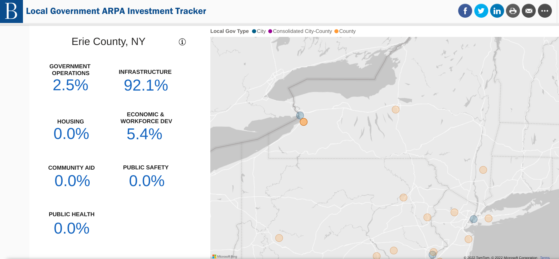
The Brookings ARPA Investment Tracker is one of several sites monitoring the use of grant funds. Erie County’s use of the funding is highlighted here with 92% of the funding being used for infrastructure purposes. Other New York State government interim reports can be found here.

But even with all of this publicly available information, and aggressive marketing by the vendor community, there seems to be a limited amount discussion about how these major federal grant funding programs can be woven into local geospatial initiatives.  And this is unfortunate because its very clear there ARE local activities which are “ARPA eligible” in the areas such infrastructure management, economic development, health and human services delivery, housing, transportation and community revitalization to name only a few.  So who is leading the statewide local government ARPA geospatial discussion?

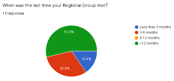
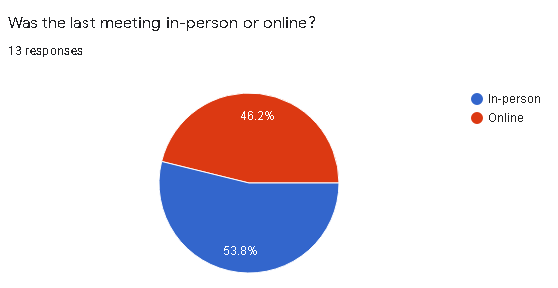
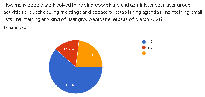
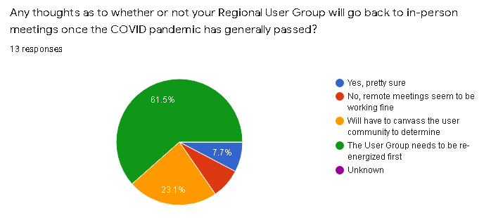
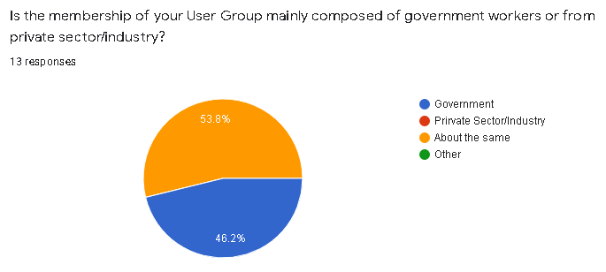
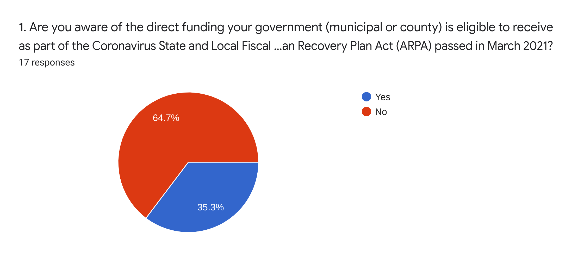
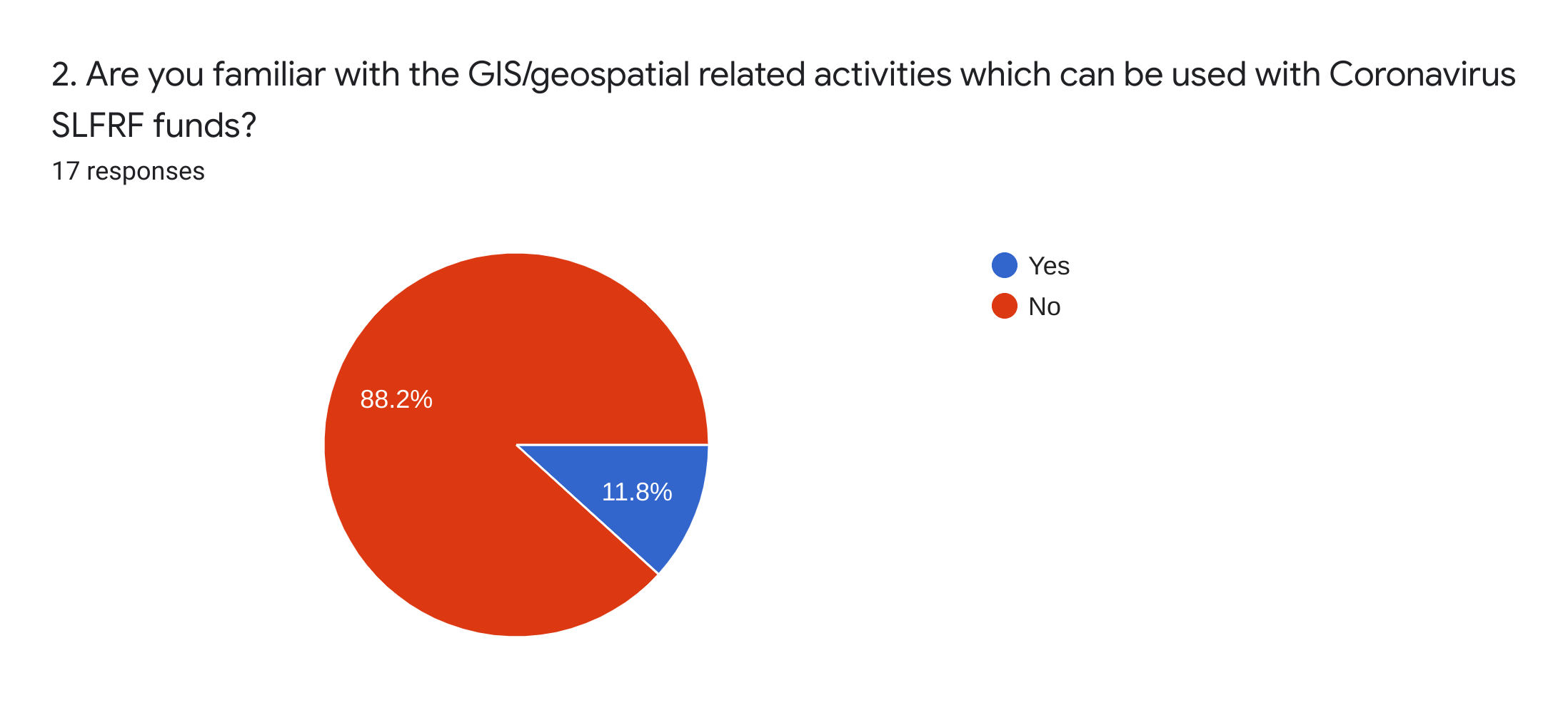
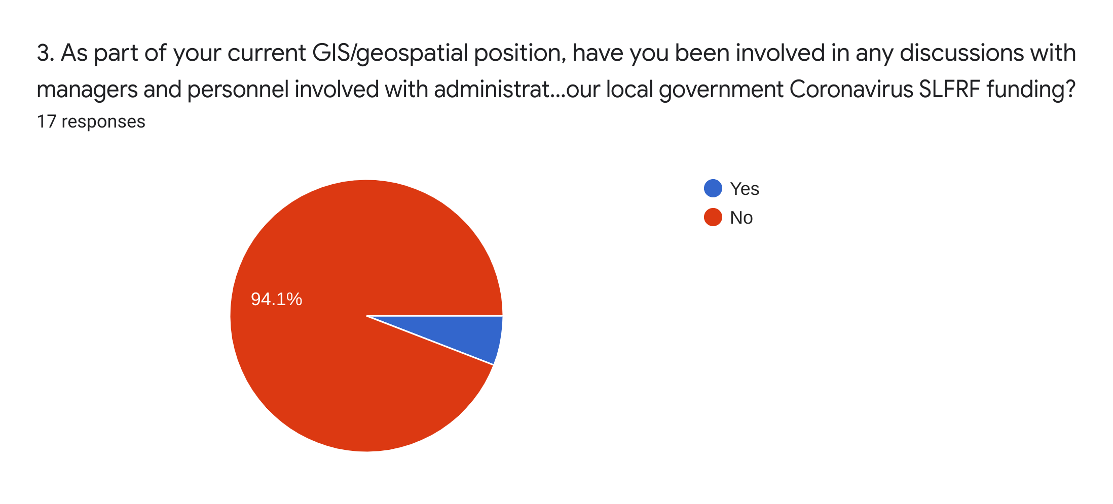
Diving a little deeper, I took out attempting to survey the statewide local government geospatial community on the ARPA and IIJA programs by issuing a simple survey via the NYS GIS listserv, as well as having a link put on the NYS GIS Assocation’s website (thank you, Association webmasters).  Perhaps I would have gotten a better response to the survey offering links to both of the funding programs, but instead, wanted to capture the respondent’s immediate understanding/awareness of the programs when opening the survey.  Providing links to the programs would have defeated the purpose of the survey.   And I made it clear the survey was only for New York State local government users and/or their contractors.    That takes a lot of potential respondents off the table via the listserv and with local government representation in the Association hovering around less than 25% of the total membership, I wasn’t sure what the response would be.  Though not included in the images below, I emailed a handful of former county colleagues separately ahead of the online survey which resulted in very similar results.

The results can hardly be considered a statistically representative sample of the statewide local government GIS user community.  I received only 20 responses of which 18 provided usable data.   As such, I would submit the following pie charts can be considered illustrative or reflectiveof the current overall awareness, if not understanding, of the current ARPA funding programs.  While only a third of the respondents indicated they were even aware of the ARPA program (first pie chart),  there was barely any understanding of the funding as it relates to geospatial (second pie chart) and only one of the respondents indicated he/she had been involved in any discussions regarding the use of ARPA funding (third pie chart) in their organization.   Though to some degree many GIS practitioners across the state often hold down technical positions in department-line staff positions which are normally far removed from the grant funds discussions being held in much higher administrative offices.

Unfortunately, as historically been the case, the top level NYS government associations noted above have rarely made GIS/geospatial a visible and outward facing part of their agenda.  Even today, Its hard to find anything really meaningful for the local government GIS community when using keyword searchs such as  “GIS, geospatial, or mapping” on any of their websites.  And its highly doubtful there will be, or can be, any real meaningful advocacy through any state program offices as this political or elected official outreach framework doesn’t even exist on behalf of local government GIS programs.    As the next generation of local government GIS/geospatial programs evolve, particularly in the urban environments where the focus will be more on the public infrastructure, utilities, sustainability and climate change impacts, large scale and high resolution mapping and surveying – the collective internet of things (IoT) – discussions and geospatial strategies with most state government offices in this space will  become more distant.    Geospatial programs for different levels of government in New York State evolving in completely different directions.   Albeit for sure New York City is on a different level when is comes to infrastructure and underground mapping, but it’s Underground Infrastructure Project concept does represent an important direction of the next generation of local government GIS programs in urban areas across the state.  It’s just a matter of degree.

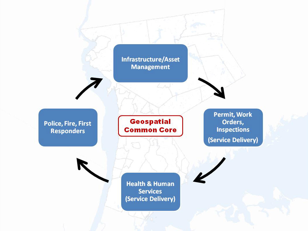
The list below, from an ESRI publication and is available on numerous websites, highlights the local government programs in play.  No, not necessarily direct funding to your GIS office, but does serve as a roadmap of who GIS practioners should be talking with at the local level.  EcoDev, public health, infrastructure and public works, and cooperative efforts with utilities.  And then find out who is administering your government’s ARPA funding.    You can be assured someone or some agency has dibs on the funding.  And apparently the GIS programs are only visible in the rearview mirrow. 

The four major ARPA funding program areas include:

1.  Support public health expenditures, by, for example, funding COVID-19 mitigation efforts, medical expenses, behavioral healthcare, and certain public health and safety staff
2.  Address negative economic impacts caused by the public health emergency, including economic harms to workers, households, small businesses, impacted industries, and the public sector
3.  Replace lost public sector revenue, using this funding to provide government services to the extent of the reduction in revenue experienced due to the pandemic

4.  Invest in water, sewer, and broadband infrastructure, making necessary investments to improve access to clean drinking water, support vital wastewater and stormwater infrastructure, and to expand access to broadband internet

Within these overall categories, recipients have broad flexibility to decide how best to use this funding to meet the needs of their communities

While actually securing funding is much easier said than done, often requiring great grant and proposal writing skills as well as involving many individual offices and agendas in the organization.  But the almost complete lack of even a discussion by the statewide local government GIS/geospatial community to date seems amiss.

There are so few funding opportunities such as these 2021 federal grant programs to take advantage of.  These are generational programs.  Right now the onus of finding representation and advocacy for local government GIS funding in the federal grants arena falls squarely on local government GIS leaders and their representatives.  As well as local GIS practitioners.

Right now, though, the silence is deafening.

Taking a Peek Under the Hood: New York State GIS Association

How’s Your Regional GIS Association Group Doing? Biden’s Infrastructure Plan. And Dude, What’s Up with Senate Bill S1466?

Its mud season in the Adirondacks so outdoor activities are kinda slow in the North Country.  Not much on the trails and the black flies loom.  Similarly is the blog content, scrounging around for new material and the like.  Couple articles in development hoping to pull together over the next couple months.  Some cool stuff coming out of NYC.  Seemed like a good time to pull together some topics and issues I’ve been staring at for a while.  Much of it related, for the most part, to the NYS GIS Association.

New York State GIS Association Regional Groups

The end of last fall I started a conversation with a GIS colleague who was responsible coordinating meetings for a local/regional GIS user group. An honorable task given the amount of time and effort which goes into doing so – often solo or with only one or two other folks.  Our conversation focused on a combination of declining attendance and participation throughout the region albeit at the time this may have been more of factor of COVID.  The play book almost the same everywhere:  virtually no in-person meetings, Zoom fatigue, and/or in general everyone completely pre-occupied with the pandemic.  All of this adding to the challenge of working with others to develop and propose meeting themes which would/could focus on something other than COVID.  And as we all know, much easier said than done over the past 16 months.

Curbing my own personal thoughts and opinions about where the profession is headed in this space across the Empire State – fodder for another article and another day – I put together a short 10-question Google forms questionnaire which was sent to the 15 regional coordinators listed on the Association’s Regional Coordination Committee web page.

Response rate was actually very good as I received responses from 14 of the 15 individuals I sent surveys to.  One of the 14 opted not to complete the survey leaving only one coordinator not responding.   Selected questions are listed below for which I’ve included summary results.   A spreadsheet containing all questions and and responses by all respondents can be downloaded here.  For the purposes of this article I removed the name of the Regional User Group so responses could not be linked to a specific person or group.

Taking a look at some of the questions and grouped responses:

1. When was the last time your Regional Group met?

2.  Was the last meeting in-person or online?

3.  Whether in-person or online, how many people participated in the last meeting?

4.  How many people are involved in helping coordinate and administer your user group activities (i.e., scheduling meetings and speakers, establishing agendas, maintaining email lists, maintaining any kind of user group website, etc) as of March 2021?

5.  Any thoughts as to whether or not your Regional User Group will go back to in-person meetings once the COVID pandemic has generally passed?

6.  Are any future Regional Group Meetings scheduled?

(Note:  During preparation of this article one Regional Group announced a Fall 2021 in-person meeting

7.   Is the membership of your User Group mainly composed of government workers or from private sector/industry?

8.  When User Group Meetings are held, do the topics and content of discussion focus on local/regional geospatial issues or more on statewide GIS issues?

Synopsis

Given the high percentage of the number of regional coordinators who responded to the survey (14 of 15; one responding to me but not completing the survey) the information gathered should be considered reflective of the current activities and engagement of the regional groups.  Admittedly the survey was really only 10 questions and completed during our time of  COVID, thus one could argue that some of the organizational issues which the Association is facing is similar to other organizations due to the pandemic.

That said, couple immediate takeaways on the pulse of the Association’s regional groups:

While the pie chart shows nearly 54% (7 of 13) of the groups haven’t met in over 12 months, overall its probably closer to 60% as I suspect the two groups which did not respond to the survey have not met during the same time period as well.  One of those for sure.  Sixty percent is significant.

Closely related is the question about whether or not coordinators anticipate getting back to “in-person” meetings after the pandemic has passed.  Seemingly more relevant, however, was the issue of “re-energizing” the group first (61% or 8 of 13 responding).  My guess it’s safe to assume the other two survey non-respondents are in the same space or mindset – and the percentage goes to a whopping 66% – 10 of 15.  75% of those responding indicated the next meeting wasn’t even planned and again, if you throw in the non-respondents to this questions it goes to over 80%.

A noticeable feeling of malaise?  Seems like enough to give the Regional Coordination Committee Co-Chairs something to think about.

Findings to other questions which included, for the most part, anticipated results such as:

  • Meetings taking place (independent of how long ago) were about half in-person and half-online)
  • Numbers of people participating in meetings (in-person or online)
  • As we all have painfully come to know, normally a handful of people (in many cases only 1-2) individuals coordinating the group and meetings
  • Probably didn’t ask the question properly, but nonetheless it appears the groups are split about 50-50 on private/industry sector vs. government individuals; and
  • Meeting agendas/discussion tends to focus about 50-50 on local/regional issues vs. statewide issues

Biden’s Infrastructure Bill

I included the question about meeting content (local level vs. state level) to get a sense of the discussion as to who/what may be directing the narrative.  Why, you say?  How about Biden’s $2.3B Infrastructure Plan.  Rarely has so much federal money been allocated which links itself to local and regional GIS programs.  Roads, buildings and utilities, bridges, public transit, water and sewer systems, disaster resiliency, public schools, and much much more.  Large amounts of geographic features and systems best managed at the local level.  And with local resources.  If not local and regional governments themselves then with trusted consultants and business partners.  Engineering consultants with broad and capable geospatial capacity.

Yes, the time for local and regional geospatial programs to proactively and reach out to state organizations such as the NYS Association of Towns, NYS Association of Counties, ot NYS Conference of Mayors to work towards making sure this new funding sources are secured for local use and application in the geospatial space..  As well as enhancing collaborations and efforts with professional organizations such as the New York State Society of Professional Engineers and New York State Association of Professional Land Surveyors which have an established presence in Albany.

Of course state assets are in play with regard to this funding, but local and regional geospatial programs, in May 2021, cannot afford to sit on the sidelines to wait and later find out distribution of this new federal funding is going to state programs first and being left to fight for the remaining scraps. And/or left to some funding distribution formula which included no local and regional geospatial programs input.

Time now for local and regional GIS/geospatial programs and organizations to mobilize on this funding opportunity.

Senate Bill S1466

Hello, McFly? Anybody home?  Anybody watching and monitoring anything with regard to the state legislature and legislation which is connected  to the Empire State geospatial space?  In the big scheme of things, S1466 probably doesn’t amount to much but it does seem something is amiss in the broader context when the words Geographic Information Systems Mapping Technology are used in describing any proposed New York statewide legislation and it goes completely under the radar screen without review and input from the statewide geospatial community. Can’t say absolutely no discussion because something, on some level, some people, somewhere, were talking and exchanging information to frame the legislation.  Was the Association part of that discussion?  Or maybe your Geospatial Advisory Committee?

And a bigger head scratcher is connecting the state GIS office with “strategic planning and municipal study assistance”.   Specifically the proposed legislation reads, in part:

“The usage of available floor space within a given political subdivision
is a critical detail. Evaluation of floor space usage allows the local
area to understand how buildings are being used, and evaluate whether
new zoning or construction plans are needed to stimulate activity in
certain sectors. However, conducting a study through questionnaires and
or geographic information mapping (GIS) technology is difficult and
costly for local entities. On the other hand, the Office of Information
Technology Services already maintains statewide GIS information and can
readily adapt that material for more specific purposes.”

This legislation would allow towns, villages, cities, and counties to
request GIS and study assistance from OITS to undertake a review of
floor space usage. Such assistance could include specific GIS maps,
online questionnaires, and other technological methods that would assist
the conducting of such studies.

Maybe I need to get out more.  Granted, if passed, the whole process of ITS of getting involved presumably wouldn’t happen unless requested locally, though it is interesting to see this office ready to provide these professional services.  Also, interesting it hasn’t ruffled a few feathers in the professional planning and GIS consultant communities as well.  NYS Association of Regional Councils?

Almost two years ago I made reference to a similar geospatial community asleep at the wheel legislative moment with regard to Senate Bill 9061 involving Google Maps.  Have there been similar pieces of legislation?  In absence of full-time staff – including an Executive Director who can operate in the Albany space – its almost an impossible task on staying on top of pending legislation proposed by others.  To say the least of identifying sponsors and proposing legislation for the benefit of the industry and membership.

One way or another, the legislative space is where the Association needs to expand and build capacity.   Thus far it hasn’t been easy and will continue to be difficult to do so.


Belated News Flash: Empire State GIS Web Maps Got Juice!!

Maybe a bit of yesterday’s news, but apparently many of us in the statewide GIS/geospatial circles were asleep at the wheel this past December when Governor Cuomo signed Senate Bill 9061 amending section 4511 of the Civil Laws and Practices Rules (CLPR).  In laymen terms, the bill “gives Google Maps and other global imaging websites the presumption of accuracy when they are used as evidence in New York courts.   Information taken from similar sites (web mapping services, etc) to Google Maps would be presumed accurate unless “credible and reliable evidence” is presented showing that it is not.”   The bill was introduced by Senator Michael Gianaris (D-Queens) earlier in 2018 and approved on June 15, 2018.  I reached out to Senator Gianaris’s office to inquire regarding his interest and/or constituent support in this space, but my emails were not answered.  If you are so inclined, the full grownup version of the bill can be found here.

This downtown Peekskill, New York Google Maps image is a staple in context of submitting “imagery” as evidence in New York State courts. Though readily available and easy to access by litigants, other government-based web mapping programs across the state often contain more detailed information and are available for increased use in court cases.

The reasons for the lack of notice, or interest for that matter, are probably for a myriad of reasons.  Could be there was simply a lack of attention because the statewide geospatial community was still dizzy from excitement by passage of the National Geospatial Data Act of 2018 last fall and its anticipated benefits to government and business GIS programs across the Empire State.  (Btw – if you are keeping a GDA scorecard, here is a May 2019 presentation on how the Act is moving forward on behalf of your GIS program.)

Though having received little attention and discussion across the GIS/geospatial communication channels and/or social media, the approved S9061 2018 legislation actually received a fair amount of dialogue in New York State law journals and blogs (i.e., Bleakley & Platt, Neufeld, O’Leary & Giusto, and Sahn Ward Coschignano among others).  With no real formal monitoring process or legislative agenda to effectively influence legislation on behalf of the statewide “profession”, legislation such as S9061 may continue to go unnoticed.  By comparison in contrast to the legislative agendas and committees of aligned Empire State geospatial professions such as surveying and engineering.

While Google internet mapping content will continue to be a norm, this legislation provides the opportunity for expanded credibility on the value of government and public facing internet web mapping sites to the legal community and in support of the  judicial process.   And by extension, one of the primary reasons in passage of S9061 – cost savings – as the new law should save litigants significant time and money and speed up trails.  In some instances, litigants have had to pay for companies to fly over a desired area and photograph it at a high cost, so that a witness would be available to authenticate the picture. Passage of S9061 also represents yet another way in which New York State legal rules are changing for the better to accommodate new technology. Notes Adam Rodriguez, Esq., attorney at Bleakley & Platt in White Plains, “This is a very practical amendment to the C.P.L.R. that will promote efficiency by saving time”

Using approximately the same Peekskill footprint as the image above, this Westchester County web mapping application renders completely different data including planimetrics, utility poles, and a sanitary sewer network. Increased outreach from government GIS programs to the legal community can illustrate the detail and richness of data which can be obtained from online web mapping programs.

Of course while the legislation gives the legal community more freedom in the use of online mapping content, it still recognizes that it may not be entirely correct and gives relief to opposing parties to challenge admis­sion of the web map content through “credible and reliable evidence that the image, map, location, distance, calcula­tion, or other information” does not “fairly and accurately portray that which it is being offered to prove.”  As such, expanded use and access to online web mapping content will increasingly require attorneys to better understand both the accuracy and limitations of the geospatial products (particularly hardcopy products generated from online applications) being submitted as evidence.

Post-World War II (1947) imagery of the same Peekskill footprint. While the Westchester County 1947 photography is of outstanding quality, conversion of such panchromatic photography to digital format can often introduce various types of errors and distortions. As such, not all “online content” is always correct and the legal community will need to continue to be cautious – and educated – about using “as is” online web mapping products.

The bill will make New York State practice consistent with Federal practice, which allows courts to take judicial notice of Google Map images because they “can be accurately and readily determined from sources whose accuracy cannot reasonably be questioned” under Federal Rule of Evidence 201.

Another plus for our tax payer funded geospatial products.  Albeit not on a day-to-day basis, but nonetheless, providing cost efficiencies in the judicial system and a little more something for the GIS program return-on-investment (ROI).

Talk to your government attorneys or firms which represent your GIS program about Senate Bill S9061.

Views on the 2018 New York State Geospatial Landscape

There’s probably enough below for a couple blog posts but I ended up throwing everything in together and stirring it up – so to speak.  The language on Part 189 (tax mapping) could be a post by itself.  Kind of all over the place, even revisiting some topics I’ve touched on before as part of eSpatiallyNewYork.  Part wish list and part commentary.  Ten items. More or less.

  1. Promoting NYS Local and Regional Government GIS Development:  This is a frequent mantra of mine and with the  constant advancements in computing and geospatial technologies it’s worth considering on a regular basis.   And most certainly as part of this year’s wish list. Opportunities abound across the Empire State to help local and regional governments  jumpstart and/or solidify their GIS program.   For example, funding is available through the NYS Environmental Facilities Corporation focusing on infrastructure systems much of which is managed at the local level.  Or the large amounts of funding being made available as part of Zombie Remediation and Prevention Initiative through the NYS Office of the Attorney Genera  And the detailed inter-government discussions on the new Shared Services Initiative  which includes funding as part of the adopted FY2018 state budget.  GIS is the shared services technology. And regional GIS programs as part of the New York State Regional Economic Development Councils or by extension the New York State Economic Development Council?   GIS tools are at the foundation of economic development.   Not perfect fits,  but funding opportunities do exist in these program areas.

At the core of local and regional GIS programs is powerful server technology (local and hosted) that not only has the capabilities to support multi-government day-to-day business functions  but also provides the framework to publish geospatial content via map services.  Call it what you want Open Data, government transparency, or data sharing  but it is within this context that state agencies, nonprofits, academia, as well as  business and industry all have access to local data.  Let’s have 2018 statewide focused discussions on extending local and regional GIS capacity based on cost effective and server-based multi-government initiatives.

  1. Building GIS Association Legislative Capacity: While the Association has grown in so many positive ways over the past decade, the challenge continues for the organization to have its presence and mission heard in Albany’s governing hallways.  It is no small effort – organizationally and financially  to build this capacity.  Many similar professional organizations have full-time staff and Executive Directors whose job is to create awareness among elected officials, secure funding, and promote/influence legislation on behalf of the membership.    But currently the Association’s legislative efforts are in the hands of member volunteers.  And while Legislative Committee volunteers were able to coordinate a “Map Day” last May in Albany to introduce the Association to elected officials, the Association has yet to establish itself on the same playing field of recognition with other statewide geospatial heavyweights such as the New York State Society of Professional Engineering, New York State E911 Coordinators, and the lobbying efforts of large New York State based geospatial businesses.  Complicating the equation are Association members who hold licenses or certifications in other professions (i.e, engineering, surveying, photogrammetry, landscape architecture, AICP,  etc) and find themselves in a quandary as to support the Association’s agenda or the profession/discipline which holds their license.  To some degree, this issue manifest itself as part of the discussion with the Geospatial Data Act of 2017 which initially had lines of support drawn heavily along professional affiliation.  The Association must keep up the good effort and find a way to compete on the Albany stage.  Let’s hope the Legislative Committee can build upon its 2017 accomplishments and make further inroads in 2018.
  1. New York State Geospatial Data Act of 2018:   Not really,  but it DOES sounds great – right?   Close our eyes and make believe there is a state-equivalent of the much hyped (Albany) federal National Geospatial Data Act (NGDA) of 2017.   Just think of it:   A process across the Empire State in place to magically aggregate our local government tax-payer funded geospatial data assets into National Spatial Data Infrastructure (NSDI).  Newly appointed and designated state agencies responsible for providing support (similar to the designated federal agencies)  to make our geospatial contributions consistent with the federal data themes and standards as outlined in Section 6 and 7 of the proposed NGDA legislation.  Ultimately being made available via the GeoPlatformContinue reading

NYS 2016 Geospatial Legislation: The Beat Goes On

Have been a little remiss in the blog content space of late and now trying to play catch up with a couple articles and stories in the works albeit nothing finalized.  With August typically being one of the slower months across the board, it’s always a good time to take a step back and see how the geospatial/GIS profession is growing across the state in context of making its presence known  or at least recognized and referenced in the legislative arena.   This year’s summary provides a little more fodder for discussion and content than in the past couple years – even to the point of dulling the urge to write in that very special way about one of my other favorite New York summertime geospatial topics:  The Geospatial Advisory Committee. The GAC.

State of the State

Always appropriate to start at the beginning of the year with the Governor’s State of the State “Built to Lead” themed speech (January 13th) which did offer some optimism – albeit indirectly – for investment and growth opportunities in geospatial technologies across the state.  Most notably with references in the areas of infrastructure development.  Even though many of the investments itemized in the speech are for major public facilities such as LaGuardia, the Jacob Javitz Center, and Penn Station – btw to the tune of $100 billion –  there is still room for enthusiasm in the GIS community hoping that even small portions of the $100 billion investment can trickle down to local government geospatial  programs to  support bridge and road management initiatives, public water/storm/sanitary systems rehabilitation projects, evolving resiliency projects, and many other infrastructure related efforts.  And best of all, providing funding opportunities for the many deserving GIS and civil engineering businesses which continue to support and help build statewide geospatial capacity. While it’s almost certain that the $100B funding is spread out over many appropriation bills, one can see the magnitude of the statewide infrastructure focus and priority by performing a keyword search on “infrastructure” in the New York State Bill Search form. Results? Fifty-seven bills match the search criteria.  Granted, not every bill is specific to geospatial & infrastructure – but it’s a damn good starting point for the statewide geospatial community.  And you can be well assured our brethren in the engineering, surveying, public works and aligned disciplines are already well engaged in tracking down the funding.  And btw, if you’re really interested and by comparison, do a similar search on keywords such as geospatial, mapping, geography, or GIS – and make note of the search results.  I’m by no means an expert in using the form, but by using it only casually, one can get a sense of the potential funding sources.

As in past State of State speech agendas, the governor makes reference to other should be GIS staple disciplines such as economic development (REDCs: Regional Economic Development Councils) and tourism – two very high level and visible government programs which the statewide GIS community has yet to make broad and sustaining inroads with.  Granted the current state administration’s REDC organizational chart is problematic in that these boundaries do not coincide with the existing NYS Association of Regional Councils boundaries, GIS-based economic development and tourism websites should continue to be a top priority for every county and/or regional planning commission across the state.

 2016 Bill Search

Certainly not an exhaustive list, but the following does provide a general flavor of the types of  geospatial/GIS-related bills which were either newly introduced or carried over from previous years.  Search results included:
Continue reading

NYS Local Government GIS Common Core: Part 1

At the 2015 NYGeoCon in Albany, I presented a paper focusing on several GIS applications which often support and justify GIS/geospatial development at the local level.  I refer to these applications and program areas as the “GIS Common Core” and it was my intent to use the presentation as a starting point to expand the discussion further as part of this blog.

While some of the GIS Common Core program areas are not new to the discussion, several factors have contributed to elevating these day-to-day GIS functional areas to the mainstay of local government geospatial efforts.  Though these factors and opportunities vary greatly across the state, some of the more obvious reasons why “GIS Common Core” applications are becoming the foundation of local government programs include:

  • Improved large-scale spatial data integration across key business applications (assessment-inspections-permitting-public safety-utilities)
  • Better address standardization as a result of E911 implementation
  • Significant improvements on the integration between GIS and AutoCAD technologies
  • Establishing capacity to fulfill ongoing/permanent regulatory and reporting requirements (MS4)
  • Broad deployment of software programs in which using/collecting/maintaining X,Y data is implicit and available by default; GIS/geospatial is often no longer considered an “optional” feature
  • Leveraging flexible, easy-to-use browser-based applications which are accessible in a wide range of environments, particularly in the growing government mobile work force.  A work force which expects maps anywhere anytime.
GIS Common Core application areas in local government

“GIS Common Core” application areas in New York State local governments

Continue reading

2015 NYS GIS Legislative & GAC Summertime Blues

While a good chunk of the GIS community was recently at the big group hug in San Diego at the annual ESRI UC (btw – kudos to both City of Rochester and NYC Department of Sanitation for Special Achievements in GIS (SAG) Awards),  the summer government-based geospatial landscape here in the Empire State couldn’t be any different.  Government GIS –  as in municipal, county, regional and state programs – continue to creep along.    Government GIS program administrators and project leaders, and speaking here about local government GIS projects, maintaining the same ol’ same ol’ waiting patiently for a game changing statewide GIS program/project which will magically institutionalize and expand their geospatial structure.  Though in reality, local government GIS leaders continuing to endure a statewide GIS enabling program that plods along at the pace similar to an endless loop of Brian Eno’s Music for Airports.   Sure, a conference here, a webinar there, a new skin on pieces of the ancient NYS GIS Clearinghouse – all for meaningful cause on some level –  but at the end of the day, or really the end of another legislative year, a statewide program that does not produce any specific legislation action which results in earmarked funding or enabling support o help build GIS capacity in local, county, and regional governments.   Yes, those legislative appropriations which are necessary to build and sustain geospatial at the local level.

The Governor’s January 21, 2015 State of the State talking points provided an element of short term optimism identifying several priority areas including infrastructure/transportation, economic development/tourism, Regional Economic Development Councils, and public safety, some of which are at the foundation of established geospatial applications.  Unfortunately, as has been the case in years pass, there has been limited discussion or action since the January presentation among the statewide GIS leadership on how to leverage the Governor’s priorities on behalf of the geospatial community.  The one exception of course being public safety which will continue to dictate the direction of much of the so-called statewide GIS “coordination” discussion as long as the GIS Program Office is buried deep inside of the ITS Public Safety Cluster.  Of course not to question the importance of public safety applications in the broader GIS context,  so noted and recognized, but until an independent GIS office is created – and its absolutely not going to happen in the current political climate – public safety related geospatial themes will continue to take center stage in the statewide GIS coordination discussion.

Therefore, as I have done in previous years, I took a few moments to scan the legislative search engines to see if any new legislation may have been introduced by members of the NYS Legislature during the 2015 session which would include either direct or indirect funding to support statewide GIS/geospatial program development.   For those who are interested, I came up with results almost identical to the search results twelve months ago.  One can find selected pieces of legislation containing a  “mapping” component  in the areas of Alzheimer’s research, autism, and breast cancer research.  With the 2015 Legislative session now behind us, here’s a comprehensive summary.

So what’s the point?  The point is that the NYS GIS Association has grown immensely over the past decade and is now involved in many areas of the profession across the state. As noted in previous posts, one area in which the Association is still in its infancy is in building and creating a presence in the New York State legislative arena and creating its own legislative agenda.  And the lack of any geospatial-related legislation introduced by the NYS statewide legislature over the past several years  speaks to the lack of the Association’s presence in this space.  And such “legislative” support does not necessarily have to be in just the development of earmarked funding.  For example, it could also include legislative assistance – and expanding the discussion – on helping leverage existing appropriations in agencies such as the NYS Environmental Facilities Corporation (NYSEFC) which administers both the Clean Water and Drinking Water State Evolving funds.  In early July of this year, NYSEFC issued an announcement of a $50 million dollar grant program making funding available for local drinking water and wastewater improvements.  Yes, there are many earmarks and stipulations in the NYSEFC grant, but illustratively, its potential as a funding source to expand and highlight geospatial technologies at the local level as part of rebuilding the decaying public infrastructure cannot be ignored.

The Association’s legislative presence needs to be autonomous and completely independent – particularly from the Geospatial Advisory Council (GAC) which earlier in the year, as outlined in its new, wildly fascinating organizational chart, attempted to neuter the Association to the role of providing “professional development” while meanwhile taking on the role itself as to  “advising decision makers”.   Somehow determining along the way that the expertise and composition of the GAC membership was more qualified and better positioned than the entire Association membership to interact with decision makers.  If decision makers means advising their immediate supervisors, then maybe so.  But certainly not elected officials and politicians – the place where the “advice” and well scripted dialog needs to be directed.   Money here says the day GAC members who are government employees, to say the least of a politically appointed state government GIO, start independently interacting with decision makers and politicians in any meaningful and outward/visible way will also be their last day of employment.  This is work for industry-focused professional nonprofit Associations administered by real Executive Directors.  Not government employees.

To be truly independent and representative of the statewide geospatial membership, and particularly to the local government constituency, the Association needs to come out from under the shadow and footprint of state government-heavy committees/programs and engage with legislative sponsors on its own terms. (btw – GAC perfectly illustrated the Association’s need to flee the so-called new coordination framework in the new organizational chart of GIS coordination in NY State – with the dominant shaded state government rectangular box at the top of the chart.)   My guess is that the GAC leadership didn’t use a Hillary Clinton-type advance focus group test to see if anyone in the statewide GIS community really understood the chart  or for that matter what GAC is really supposed to do. Though some blame should be placed the Association leadership for even letting GAC publish the new organizational chart showing it (the Association) in some subservient capacity to the self-declared state government triumvirate and GAC, if even only in context of an advisory role.

The Association should also stop serving as a mule in providing GAC with an annual candidate list of potential members whose mere presence at the table implies endorsement of GAC’s activities.  Remove itself, along with local government individuals, from the quarterly parade to Albany to listen to state government departmental GIS applications, work plans, and projects and priorities of state government programs. While the dialog at GAC may be useful and productive in context of state government program updates and activities, its mostly for the benefit of the choir of state employees at the meeting and those making the presentations themselves.    Take a look at the minutes from the June 2015 GAC meeting and digest all of the riveting conversation concerning the needs and future activities of non-state sectors of GAC i.e., utilities, academia, nonprofits, and of course local government, and decide for yourself.  But maybe it was because it was a “state” sector designated meeting?  And other sectors will get their chance at future GAC quarterly meetings to dominate the conversation?  Yeah, probably.  Exactly why I formed the Association over a decade ago – to help lead the discussion and focus of statewide GIS development in a different direction and away from established Albany-centric GIS programs and personalities.  And the business sector?  BUSINESS.  Fugetaboutit.  Probably the most important factor which is going to shape the NYS geospatial landscape in the next decade doesn’t even really participate in the discussion.  And yes, there is a reason why business doesn’t run in the GAC circle.   And ironically, the only place the geospatial business community is going to participate and contribute is within the Association structure.

It’s time for the Association’s leadership to recognize and embrace the potential, and for that matter, its obligation, towards building an independent legislative agenda and professional appearance on the New York State political stage.  Operating and orchestrating on its own.  Working with other appropriate industry groups and committees where input and collaboration is requested and warranted as needed, but beholden to none and/or other hidden agendas.  The Association must establish itself to set the agenda of  statewide geospatial priorities. Not GAC and most definitely not state government employees or agencies.

That time for action is now, or the hopes of a meaningful 2016 geospatial legislation report reflecting the growth and expansion of the GIS profession will be a carbon copy of 2015.  And the beat will go on and on and on.   Just like Music for Airports.