The County’s Homegrown Application Provides Mapping and Data Collection Support to the Multi-Agency Western New York Stormwater Coalition
 While the Municipal Stormwater Sewer System (MS4) regulatory program may be taking a back seat in focus to COVID-19 across Empire State governments in 2020, compliance efforts nonetheless continue in the background. The DEC program has seen governments responding to meet annual submission requirements in a variety of ways ranging from full vendor supported solutions, hybrid approaches of using in-house resources and commercial-off-the-shelf (COTS) products, while others have built the solution totally in-house. Aka Do-it-Yourself (DIY).
 One such MS4 DIY organization is Erie County which provides administrative and technical support to the Western New York Stormwater Coalition (WNYSC) which has a broad geographic footprint. Erie County took the stormwater management regional lead in western New York in 1999 when it became apparent both Erie and Niagara Counties would be required to come in compliance with the United States Environmental Protection Agency (U.S. EPA) Phase II Stormwater requirements. Recognizing much of the MS4 General Permit was general in context of most permit requirements being the same for all governments, the Coalition was created in 2003 as a means to share work such as public education and outreach, development of policies and procedures, employee training – and mapping. While the Coalition is not an official Erie County government agency, it is housed administratively inside County offices.
Erie County MS4 Support
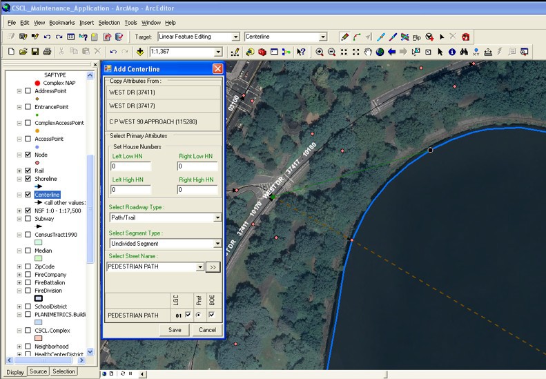
Initial development of the program started in 2012 by the current Director of Erie County’s Office of GIS, Lisa Matthies-Wiza, who was part of a team that designed databases, field applications, and quality assurance plans to manage data collection. This was facilitated through a series of grants through NYSDEC and partnerships with Erie County and Buffalo State College provided to the Coalition.
More recently, support to the Coalition’s MS4 compliance efforts has been Michael Ruffino who came to the County in March of 2019. Prior to Erie County, he had experience in the use of ArcGIS Online (AGOL) Survey123 and Collector in Chautauqua County where he was able to incorporate similar apps for the environmental health department septic systems and water supply inspections. Currently Erie County hosts all of the GIS data and hardware/software infrastructure for the entire WNYSC program.