Social Determinants of Health: How Place Can Affect Health Outcomes

Why does location matter for health?

In 1948, the World Health Organization defined Health as “a state of complete physical, mental and social well-being and not merely the absence of disease or infirmity.” This definition has evolved over time to recognize additional factors that have been found to impact health. Driven in part by improved understanding of socioeconomic influences, technological changes, and increased attention on health policy, there has been a growing effort to more thoroughly elucidate factors that determine health. Genetics, individual behavior, social factors, the physical environment, health services and governmental policies all have been found to play a role in health outcomes. Crafting effective policy depends upon a solid understanding of each of these factors, as well as their complex interactions.

Social determinants of health—as distinct from medical care—are increasingly recognized as influencing a broad range of health matters, from access to outcome. According to America’s Health Rankings, when compared with other developed and many developing nations, the U.S. ranks at or near the bottom for health outcomes related to life expectancy. However, data from the Organisation for Economic Co-operation and Development (OECD), which seeks to understand what drives economic, social and environmental change across governments, show that the U.S. continues to exceed other countries in healthcare spending.

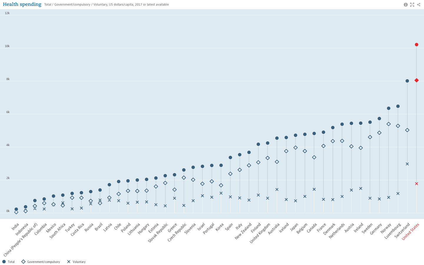
While the United States trails other developed countries in life expectancy (years), it still leads all others in healthcare spending.

Moreover, evidence illustrating the powerful role of social factors in determining health suggests “the effects of medical care may be more limited than commonly thought, particularly in determining who becomes sick or injured in the first place.” Studies have shown that states with a higher ratio of social to health spending had significantly better health outcomes for adult obesity, asthma, mentally unhealthy days, days with activity limitations, and mortality rates for lung cancer, acute myocardial infarction, and type 2 diabetes. Some studies have estimated that medical care is only responsible for 10-15% of preventable mortality in the U.S., indicating that social factors can lead to—or help prevent—poor health outcomes and inequalities.

To address this, the World Health Organization created the Commission on Social Determinants of Health in 2005. By 2008, the Commission concluded in their final report that “inequities are killing people on a grand scale”. Recommendations included improvement of daily living conditions, addressing the inequitable distribution of power, money and resources, measuring and understanding the problem, and assessing impact of action. Growing awareness also led to U.S. Centers for Disease Control (CDC) research, and implementation of a program to advance health equity called Healthy People 2020 which advocates for the creation of “social and physical environments that promote good health for all”, one of their four overreaching goals for the decade.

The Role of GIS

Location affects health. We see dramatic differences in life expectancy between countries, as well as between zip codes. Socioeconomic differences between countries are tied to disparities in health outcomes. Within the U.S., poverty and transportation affects access to healthcare. At a smaller scale, we know that safer neighborhoods, healthy and secure housing, and access to healthy food and open space are associated with healthier populations. U.S. Census data, American Community Survey data, and other sources can help tie such social factors to geography, allowing for better understanding, measurement 
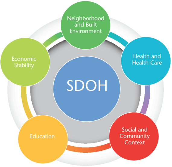
and tracking of social determinants of health. Universities, governmental and non-profit organizations now routinely collect such data and utilize GIS to help inform analysis and better decision-making, leading to stronger policies. The Healthy People 2020 Approach to Social Determinants of Health employs a “place-based” organizing framework, organized around Economic Stability, Education, Social and Community Context, Health and Healthcare, and the Neighborhood and Built Environment.  Many factors reflecting economic stability, such as poverty and employment, can be mapped within a GIS framework. Mapping education levels, literacy and language, quality of housing, environmental contaminants and areas with high concentrations of chronic disease can help to identify vulnerable populations, reallocate resources and better plan interventions and public education and awareness campaigns. Much of this data is readily available and free of charge. Furthermore, GIS lends itself well to Disparities Analytics, the development of analysis and visualization methods to monitor and report health disparities.

The Westchester Community Foundation and the Westchester Index

For 40 years, the Westchester Community Foundation, a division of the New York Community Trust, has worked to improve local and regional quality of life in Westchester County, NY by addressing community issues, promoting responsible philanthropy, and connecting donors to critical, local needs. In this capacity, the Foundation, together with the Community Healthcare Association of New York State (CHCANYS) and Westchester County GIS recently developed and released the Westchester Index, a tool developed to help understand social determinants of health in Westchester County.  The collaboration relied on data from American Community Survey, the U.S. Census survey, the New York State Department of Health as well as school districts for select health outcomes and socioeconomic indicators. The CDC Social Vulnerability Index (SVI), created by the Geospatial Research, Analysis, and Services Program (GRASP) of the CDC, was also included in the Westchester County Index. The SVI uses 15 U.S. census variables at the census tract level grouped into 4 themes (Socioeconomic Status, Household Composition, Race/Ethnicity/Language, and Housing/Transportation) to help identify communities that may need support in preparing for hazards or recovering from disaster.  Westchester County GIS provided detailed data on public transportation, land use

A collaborative effort between Westchester County GIS and the Westchester Community Foundation, the Westchester Index contains data on over 200 indicators reflecting social determinants of health.

categories, as well as locations of environmental hazards. In addition, zip code, census tract and block, school district, municipality, County Legislative district, New York State Senate and Assembly district, and U.S. Congressional district boundaries were provided by Westchester County GIS, allowing for a user to further tailor an analysis. Overall, the Westchester Index contains data on over 200 indicators reflecting social determinants of health. The interactive tool is expected to be used by planning officials, community healthcare networks, school districts, non-profit organizations and others to explore the data and better understand the factors that drive health outcomes in Westchester County, leading to more informed decision-making for greater health equity.  View the Westchester Index Story Map here.

Editor’s Note:  This article was prepared by Anjali Sauthoff.  Ms. Sauthoff is an environmental health scientist currently working with Westchester County GIS to develop integrated approaches that address climate adaptation and community resilience. Her previous research at the Energy Institute at the University of Wisconsin at Madison focused on potential mitigation strategies for reducing transportation-related climate emissions. She received her PhD from Columbia University, where she developed an air pollution exposure model and received training in the health effects of environmental exposures. Her Master’s degree is in Neurobiology from SUNY Stony Brook. She can be reached at ap768@columbia.edu.


Shared Services: Opportunities for Local Government GIS

More than a couple years ago, Linda Rockwood, who at the time was running Mohawk Valley GIS, mentioned to the NYS GIS community that she was at a local meet and greet with regional elected officials and mentioned the “GIS” word to one of NYS’s congressional representatives in attendance.  To her amazement – and dismay –  she found out the representative had a very limited awareness or understanding of GIS.

Linda’s encounter certainly wasn’t the first of its kind and I’m sure there have been numerous similar incidents in our respective corners of the state since then.  GISers gingerly starting a conversation on the broad benefits and applications of geospatial technology to government and elected officials – only to see the focus wander quickly. Maybe two or three minutes into the discussion when comparisons to Google Maps normally kick-in and/or there is eye contact with the next constituent and thinking moves to that conversation.

Unfortunately, the message – and the collective mission – seems to continue to get lost and there is recent anecdotal evidence to suggest there is still a long way to go in context of recognizing and embracing geospatial technology in NYS local governments (county, city, town, and village) as part of an increasingly important government program area:  Shared Services.

New York State Shared Services Program

Those working throughout the local government ranks should be on some level familiar with the shared services buzzword.  It’s the talk among government officials and for legitimately good reasons.  Look no further than Governor Cuomo’s commitment of $225 million in the FY 2019 Executive Budget to continue the County-Wide Shared Services Initiatives (CWSSI). The $225 serves as matching funds for a one-time match for actual and demonstrable first-year savings achieved by the Shared Services Panels through new actions implemented during calendar year 2018.  School districts, boards of cooperative services (BOCES), fire districts, fire protection districts, and special improvement districts have the option to participate as well.    The current shared services initiative augments the existing NYS Department of State Local Government Efficiency (LGe) Program – which by the way formerly known as the Shared Municipal Services Incentives program –  “provides technical assistance and competitive grants to local governments for the development of projects that will achieve savings and improve municipal efficiency through shared services, cooperative agreements, mergers, consolidations and dissolutions.”

New York State Shared Services Initiative web page

There are many recognized barriers to implementing shared services across NYS governments though as the concept evolves, governments continue to try and find ways to consolidate services in specific areas such as municipal justices, zoning and code enforcement, construction/building/maintenance inspections, and in the establishment of health care consortiums to name only a few.   That said, it’s worthy to note the limited number of GIS-centric shared services proposals submitted by both the New York State Association of Counties (NYSAC) and  New York Council of Mayors (NYCOM). Specifically:
Continue reading

2018 Westchester GIS User Group Meeting

Westchester County GIS has been fortunate to build a broad and diverse community of GIS users and followers over the past two plus decades which is embodied at the our annual GIS User Group Meeting each May.  Similar to many first generation GIS government programs which were created in the late 1980s/early 1990s, most of the first decade worth of geospatial programs and applications Westchester County GIS developed were government focused.  But as geospatial technology grew at warp speed in industry and business and combining the development and availability of a high accuracy countywide Westchester County digital base map,  the visibility of the program quickly expanded.  Interest from public safety, nonprofit, academic and civic groups soon followed.   And not to minimize the importance of the continued political support the program has maintained over the past two decades at both the county and municipal level.   Illustrative of this year’s May 17th meeting held at Purchase College, nearly 170 representatives from  government, industry and business, utilities, academia, nonprofits,  community groups, and the military convened for the sharing of presentations, geospatial solutions, and best practices to move the countywide and regional geospatial agenda forward.

2018 Agenda

In years past there had always been an effort to keep the presentations and agenda diverse – a little bit of everything.   While this has generally served us well over the years, this was the first year we had a specific theme:  GIS for Resiliency and Sustainability.   This was in response to recent work our GIS program had completed in context of investigating potential impacts of projected sea level rise on county-owned assets as well as administrative changes in the Westchester County Executive  office as a result of the November 2017 elections.  In the process of bringing these two issues together and including the Office of Sustainability at Purchase College, we were able to add Westchester County Executive George Latimer and Purchase College President Thomas Schwarz to our agenda.  Both mentioned and acknowledged the importance and relevance of technology and geospatial in supporting the regional sustainability agenda.

Westchester County Executive George Latimer talking with 2018 User Group meeting attendees. He made reference to the use of geospatial technologies in confronting Climate Change issues.

2018 Speakers

Working with the theme of GIS for Resiliency and Sustainability, we were able to include two well recognized state government speakers in Mark Lowery, Climate Change Analyst with New York State Department of Environmental Conservation, and Amanda Stevens, Project Manager with New York State Energy Research and Development Authority (NYSERDA) Environmental Research Program.  With the County’s work in this space increasingly including nonprofit groups, representatives from both  Abundant Efficiency and the Westchester Community Foundation were also on the agenda.  In the mix were talks by SUEZ North American (water utility) and BetaNYC – an open data advocacy organization based in New York Ctiy.   Additionally, we continued to feature our ongoing relationship with the U.S. Military Academy at West Point with a noon presentation by Lieutenant Colonel Jared Ware.  Our afternoon session of Lightning Talks and panel discussion featured Sustainable Westchester and representatives from five local governments.

In the morning session, Amanda Stevens provides an overview on NYSERDA’s work and research efforts in the area of climate change – which includes programs in the Lower Hudson River region

Bringing it Together

Admittedly there is always a little luck in hosting conferences such as this and it only takes a day of bad weather for attendance to bottom out (been there).  Of course, nothing beats an agenda based on current and cutting-edge geospatial topics backed with recognized speakers, but there are a couple other factors worth noting that seem to help make all of this work for us, including the following:

All Things Local:    For all the benefits and advantages of the larger shows, localizing the day’s content and message for local/regional like-minded individuals goes a long way.  Geospatial business needs and problems – and often the solutions – are conceptually very similar.  Familiar faces with familiar issues.  The organic approach.

Affordability:   Offering such events at a discount, like free as in our model, makes the event more attractive to more people.   However,  if its free, it is easy to not show.  Nothing paid nothing lost. And we have the historical numbers to show as such.  Over the past six-seven years we’ve seen a 25%-30% no show rate from the actual number of pre-conference registration numbers.    That said, we’ve learned to factor this variable in the printing of conference materials and sizing break refreshments and lunch.  We’ve also learned over the years that other groups and professional societies we’ve tried to partner with in hosting the show may be hesitant to collaborate because they (other organizations) do not want to send a message to their memberships that meetings, and certainly ones that offer Professional Development Units (PDU), are available for free. The bottom line for us is that we continue to make the show free based on vendor fees and affordable food services from the venue location.  And besides, there is no capacity to collect money online and/or to deal with bank accounts.  What little money management needs we have are handled graciously through the college.  Getting pass the bouncer at the door for free works for us.

Vendor Interaction:  I can’t say enough about how important this is.  We put a lot effort into making sure our sponsors have ample time for interaction with the attendees. Information gathered by attendees in the exhibitor area only adds to the overall value of their day.  Food and refreshments are close by so everything (and everybody) is in reaching distance of the vendors.  We also have vendor “Vendor Bingo Card” game that encourages attendees to visit each vendor table to qualify for a prize drawing.  Pretty nice incentive as this year the prize was a vendor donated iPad.   All sponsoring vendors are entitled to 5-minute “Vendor Spotlight” presentation over the course of the day.  Without vendor support the day doesn’t happen so we make it worth their while.


Everything is nearby at the Westchester GIS User Group Meeting. Vendors, refreshments, and the main auditorium are all intertwined and close. Making the experience interactive and personal on many levels. It’s a win-win for everyone in attendance. Who are those folks in pink?

The Venue:   For the past seven years, Purchase College has graciously made their facilities available to us to host the show.  Prior to that we bounced around the County at other locations, but given our relationship with the faculty in the Environmental Studies Program this became a logical spot. Centrally located in mid-Westchester.  Easy access.

A naturally lighted vendor area, albeit small, adds to the personal “feel” of the show.  One of the main reasons we originally went to Purchase during the third week in May was that the Student Union cafeteria was still open we could make lunch “on your own”.  Avoiding all the overhead and cost of providing lunch.  We’ve since been able to work with campus caterers to provide us with an affordable lunch menu which is vendor sponsored.   This “grab lunch and go” format enables users to eat where and how they want –  attending special lunch time presentations, continued discussions with vendors, or simply going outside to eat on the campus plaza.  The entire agenda is plenary format held in a cathedral style 150-seat auditorium.    We once tried a concurrent sessions format but it just didn’t work and feel right so we went back to the basics.  Post-meeting training sessions have proven to be hit or miss.  Just seems that just come 3PM after a long day of presentations, networking, and interacting with vendors, most folks are running to the exits.  Or the no-host reception down the street.

One of the ironies – and downsides – of having the show on a college campus in mid-to-late May is that spring semester is already over and students have fled campus, though  there is normally a handful attending looking for summer or full-time work and passing out resumes.    But we clearly do not have the college student attendance that is seen at comparable conferences such as GIS-SIG.

Engage the Professions:  We make a significant outreach to the “aligned” professions including engineering, public works, surveying, police and fire departments, government administrators, the planning community and increasingly nonprofits.  I wish there was an easier entry point into the 41 school districts here in Westchester County – and particularly their uber large budget bus transportation systems – but we’ve never been able to find it.     We  focus our efforts to reach the professions with individuals and technical staff that use geospatial technology.  Day-to-day work flows that has geospatial intertwined –  but is not the only focus of their business day.  Truth be told, there simply aren’t a lot of individuals locally who only do GIS work during the course of their business day.  The carrot that we offer across the board – and the common denominator – is the geospatial content we publish from our program via our data warehouse or map services.

Summary

Declining government budgets and  travel restrictions positions the Annual Westchester GIS User Group meeting as the primarily, if not only, major GIS event many of our government attendees get to each year.   It enables us to craft a geospatial message in context of local needs and applications as illustrated in this year’s theme “GIS for Resiliency and Sustainability”.  And keeping in mind the importance of their support, the event provides a great framework for industry and business to showcase their product and services.  And none of it possible without the support of the great folks at Purchase College.

Cognizant of the many differences and capabilities within the regional GIS communities,  it is often difficult to host such events on a reoccurring basis.  Perhaps some of the elements of our event can be used in helping build capacity for creating similar events for other regional GIS user communities across the Empire State.


Purchase College GIS Certificate Program

Working professionals in the Lower Hudson Region now have the opportunity to learn more about and build introductory skills in Geographic Information Systems (GIS) technology through the noncredit GIS Certificate Program available at Purchase College. The certificate program will enable students to establish GIS skill sets to augment current job responsibilities and build the “geospatial edge” in an increasingly global and technological world.

Everything happens somewhere.

While there continues to be strong interest from the regional engineering/AutoCAD and environmental communities on how to better access and integrate GIS functionality into their organizations and business offerings, Westchester County GIS staff, which is closely aligned with the Purchase College faulty and supports the GIS Professional Certificate program, is seeing a noted increase in the use of GIS mapping technology in emerging areas such as nonprofits, health and social service programs, community groups, and crowd sourcing efforts.   One of the primary reasons for this increased use is the expanded use of web and server technologies –  a noted departure from the reliance on heavy software client applications – by instead leveraging more easy-to-use geospatial applications for a broader range of users.  This is particularly true in organizations and companies with limited technical expertise and infrastructure.

Starting in January 2018, students can earn the noncredit GIS certificate in as few as two (2) semesters.  Three elective courses ( Using Maps to Tell Your Story, Getting to Know ArcGIS Online, and Using Cloud-Based and Online GIS Platforms) are being offered individually as two-day courses on weekends.  A total of 16 hours per class.  No need to try to and  attend class during an already busy work week.  Course descriptions and instructor information, as well as registration information, is available on the Continuing Education GIS web page.   Successfully completing these three Spring 2018 courses and combining with one required course (GIS Essentials or Geographic Information Systems (GIS) – offered each fall semester by the Environmental Studies program in the School of Natural and Social Sciences, on a noncredit option basis), the Purchase College GIS Certificate can be obtained in 2018.

Students may take individual GIS Certificate courses without commitment to the entire program. The courses are face-to-face courses held in a Purchase College computer lab. Students who successfully complete the four required courses are awarded a certificate by the School of Liberal Studies & Continuing Education, reflecting 21 continuing education units (CEUs).  Continuing education units (CEUs) are a way of measuring and officially recognizing the time and effort a student has  put into your education for your job or profession. As you update your credentials, are in line for a transfer, promotion, or evaluation of your current position, or want to  explore a new career, the CEUs recognize student achievement in noncredit learning activities.

Spring GIS coursework at Purchase College is particularly rich in context and timely as preparations are in progress for the annual Westchester GIS User Group Meeting which is hosted on campus by the Environmental Studies Program in May.  As one of the largest GIS User Group meetings in New York State, this year’s conference theme is “GIS in Sustainability and Resiliency” and is expected to be incorporated into each of the spring courses.

Whether trying to augment your existing career with a better understanding of geospatial technology or to begin to better understand “location based” concepts – the Purchase College GIS Professional Certificate Course is for you.    Registration for spring course work is now open.  Do it today!

GPS Telematics for Fleet and Mobile Workforce Management

Several of my posts over past 18 months have focused on a core set of applications which I have seen evolve over the past three decades that serve as the cornerstones for many New York State local and county government geospatial programs.  Increasingly and central to many of these geospatial program areas is the “mobile” component albeit much of the attention to date has been on “field/handheld” hardware and software components for both spatial data collection and updates.

Increasingly  it is becoming recognized  another mobile collection technology can add value to  an organization’s work force and business systems productivity.  Originally referred to as Automated Vehicle Locator (AVL) systems, this technology got its start decades ago focusing on the capture (mapping) of a vehicle’s location and display in a GIS or similar digital mapping system. These early systems were expensive and not widely used outside of business and industry.

Over the last five or more years,  fleet managers have increasingly adopted “AVL” technology to assist in the management of  fleet assets especially with availability of lower cost hardware components which connect  to vehicle On Board Diagnostic (OBD) ports.  This capability supports fleet managers with a wide range of metrics  providing  odometer/mileage readings, engine idling, vehicle usage and a variety of other vehicle related information.  Now recognized as “GPS Telematics”, this technology has become more affordable and accessible to a larger range of government agencies and organizations.  This modern use of the technology centers around the use of M2M (machine to machine) and telematics technologies.

Benefits of GPS Telematics

To date, much of the work focusing on capturing and analyzing data associated with field resources has been done the “old way”, i.e., capturing and recording the data by human fingers.  Historically, this method is fraught with inconsistencies. Machine-to-machine (M2M) data capture on average is far more accurate and consistent.

Fleet telematics monitor the location, movement, status and behavior of a vehicle and associated field resources.  This is achieved through a combination of the  GPS telematics device which is installed in each vehicle transmitting  location based data via wireless networks to web servers for near real time availability.  Users access location, movement and status information and metrics of vehicles via special web-based software applications or through existing in-house “vehicle tracking enabled”  business applications.  In essence, GPS telematics systems become platforms to collection and transport valuable mobile resource field information and activities.  In addition to locational data,  fleet telematics solutions provide the status of each vehicle and by extension the corresponding crew an inference of  ongoing work accomplishments and assignments to field resources.  Managers know how each vehicle is being used as well as mileage, idling status, location and speed.  Such systems can be extended to be connected to onboard systems and sensors which log activities such as street sweeping, plowing, spreading, and spraying – workflows which are particularly challenging to capture and document by hand during the normal course of business.  While Return-on-Investments (ROI) can and will vary greatly, calculating the benefits of investing in fleet telematics technology can now be  based on factual metrics such as improved routing and dispatching, reducing labor costs, improved fuel and vehicle usage, and newer more cost-effective system architecture (Cloud). Continue reading

2017 NYS Spring GIS Conference Specials

The last couple weeks I’ve been engaged in the following cutting-edge enterprise geospatial issues:  (1) staring at the sky on a daily basis,  (2) monitoring the temperature, and (3)  hoping the remaining snow to melt and the leaves to hold off in budding – both at the same time.  After nearly 33 years in County government and its boiled down to this! Why?  So we can get our aerial photography flown over the next 10-days to support our 2017 countywide base map update.  The heavy snow March 14th really set us back and the window to capture the photography is closing quickly.

So at any rate, its been easy to lose track of upcoming Spring 2017 regional one-day GIS conferences and meetings over the next 4-6 weeks.  Most of the Spring 2017 shows are held in locations accessible via a maximum 2-4 hour drive from furthermost parts of the Empire State, offer a wide range of geospatial topics and presentations, provide excellent networking opportunities among colleagues and industry representatives, and are generally light on the wallet.    For those unable to make or justify the big lift of getting to the uber ESRI conference in San Diego later on in the summer and/or chasing GISP certification credits these venues are for you.

Sounds sweet, right? So consider the following and get your travel approvals in order:

GIS-SIG 26rd Annual Conference, April 11th, Burgundy Basin, Pittsford, NY.  Unfortunately I cannot make GIS-SIG this year as it is one of my most favorite statewide one-day shows.  GIS/SIG provides the premier geospatial professional forum in the Rochester/Genesee Finger Lakes/Western New York region for GIS practitioners focusing on trends and policies relating to new geospatial technologies and current projects.  With a loyal following, the size and content of the GIS/SIG conference is broad enough to often substitute as an annual state conference for many GIS practitioners in the western half of the state. This year’s conference again includes vendor displays and an agenda covering topics such as mobile data collection, drones, 3D GIS, and ESRI software updates, as well as a keynote address from Dr. John R. Schott, founder of the Digital Imaging and Remote Sensing Lab at the Rochester Institute of Technology (RIT).  Corporate sponsorship keeps the price tag of an individual registration at under $100 for the day which also includes lunch. Online registration is still available and while you are at the GIS/SIG website you can also see the many resources and links GIS/SIG provides to its user community.  This is a great show and if you have the opportunity to attend. Highly recommended.

Long Island GIS (LIGIS)  2017 Spring User Conference, April 26th, SUNY Farmingdale, Farmingdale, NY.  LIGIS meetings and conferences have grown in structure and content over the last few years and this spring’s April 26th meeting will continue to illustrate the improvement among the Long Island GIS stakeholder user community.  Scheduled presentations from government, academia, and industry are on the agenda including topics covering mobile applications, MS4 data collection, 2020 Census Bureau update, and GIS & hydrofracking among others. Located in central Long Island on the SUNY Farmingdale campus, this is a not-to-miss conference on “the Island” for those with limited travel budgets.  Make plans to attend.  Those interested in attending can monitor conference specifics at the LIGIS homepage.

Northeast Arc User Group (NEARC) Meeting, May 15th, University of Massachusetts, Amherst, MA.  Spring NEARC meetings are conveniently located in Amherst, MA which is easily accessible to the Albany Capital District and GIS professionals in eastern New York State.  Unlike GIS – SIG, which is software vendor independent, this show is very much ESRI centric and packed with high quality user presentations. Even though only one day, the show has grown to be so popular that it now competes with the larger multi-day GIS shows and conferences across New England.   Price tag for attending:  $65 which includes lunch.  If you can afford an overnight, activities the evening before downtown Amherst and a hotel room at the UMass conference center make it even more worth your while. (As of the day of this blog post 4/4 the May 15th agenda was still in development; I did submit an abstract!).  Registration will open mid-April.  If your organization is an ESRI shop – this is a Spring show not to miss.

Westchester GIS User Group Meeting, May 11th, Purchase College, Purchase New York. As one of the largest geospatial meetings in New York State, the Westchester GIS User Group Meeting is a free one-day conference held at Purchase College. Made possible by financial support from exhibiting vendors and conference facilities provided by the college, the draft 2017 agenda  features user presentations from County government,  Westchester County municipalities, nonprofits including the Goodlands Project, and ESRI. There is also free conference training: At lunch “Leveraging Suvey123 for Mobile Data Collection” with instructor Larry Spraker and post-conference “Getting Started with How to Build Great Web Apps” with ESRI’s Mark Scott.   Also, sponsors get to present 5-minute “Lightning” talks over the course of the day.  The Purchase College location provides easy one-day access across the metropolitan NYC area, as well as the broader lower Hudson River Valley and southeastern Connecticut. Agenda and other meeting  specifics – including registration – are available from the Westchester County GIS website.

Other Venues:  If you are in the Metro NYC area don’t forget to check the GeoNYC Meetup calendar for ongoing meetings across the city. Subject matter and participation is pretty amazing.  And/or the many other geospatial related Meetups in the region covering big data, data visualization, agriculture mapping, and everything inbetween including drones. A little further removed geographically from the Empire State is the Northeast Geographic Information Society (NEGIS) conference on April 27th in Ashland, MA. You can follow and learn more about NEGIS via their blog.

The entire Empire State GIS community is fortunate enough to be close enough to a range of regional geospatial meetings and conferences which are accessible from most areas of the state and provide many of the same benefits of larger shows and not nearly as expensive.

Safe travels!

Deep GIS: Mapping What You Touch In the Subways

I’ve recently been communicating with Ebrahim Afshinnekoo who is Project Director for the PathoMap project based at the Weill Cornell Medicine Mason Laboratory in New York City.  Launched in the summer 2013, PathoMap was the first project of its kind, with the intent to comprehensively map and investigate the presence of bacteria and DNA on the surfaces of large urban, metropolitan environments such as New York City. And of course what better venue to collect bacteria samples in NYC than the subway system – the large subterranean behemoth home to 5.5 million riders on an average weekday.

I was drawn to the project in that it involves several common geospatial components the traditional GIS community is routinely involved with such as  data collection/data validation, data analysis, mobile apps, web mapping and visualization. To date, discussion on this geospatial research effort has focused mainly within the Cell Systems (scholarly journal) community, though with little exposure within the traditional NYS GIS community. While both the Wall Street Journal and the New York Times published articles on PathoMap in 2015 we’ve seen little work of this nature at statewide conferences or how it can promote similar geospatial analysis across the Empire State. With this in mind, eSpatiallyNewYork initiated this blog entry with the purpose of exposing the PathoMap project, and its subsequent global expansion (MetaSUB) to the larger statewide GIS community.

Data Collection

The molecular profiling initiative launched in the summer of 2013 with the help of undergraduates from Cornell University and Macaulay Honors College – which were soon to be given the appropriate moniker “Swab Squad”.  To create a city-wide profile, the research team first built an Android/iOS  mobile application in collaboration with GIS Cloud to enable real-time entry and loading of sample metadata directly into a database (Figure 1).

Figure 1: Data collection from the project included the “swabbing” of sites and subsequent analysis and data entry of the findings into a mobile app which are dynamically uploaded to the Cloud GIS database. Source: Afshinnekoo et al., 2015

Continue reading

2016 NYS Spring GIS Conference Specials

With my March Madness bracket already busted just four days into tournament play and watching anymore games for the most part pointless (Syracuse in the Sweet 16, really?),  combined with winter returning and getting out on the golf course also not an option, it seemed like a good time to sit down and compile my annual plug of regional one-day GIS conferences and meetings around the Empire State over the next 4-6 weeks.

Most of the Spring 2016 shows are held in locations accessible via a maximum 2-4 hour drive from all parts of the state, offer a wide range of geospatial topics and presentations, provide excellent networking opportunities among colleagues and industry representatives, and are generally light on the wallet.    And for the GISP folks, most of the shows also provide certification credits.

Sounds pretty good, right? So consider the following options:

GIS-SIG 25rd Annual Conference, April 12th, Burgundy Basin, Pittsford, NY.  Its unfortunate I cannot make GIS-SIG this year as it is one of my most favorite statewide one-day shows.  GIS/SIG provides the premier geospatial professional forum in the Rochester/Genesee Finger Lakes/Western New York region for GIS practitioners focusing on trends and policies relating to new geospatial technologies and current projects.  With a loyal membership and Board of Directors, the size and content of the GIS/SIG conference is broad enough to often substitute as an annual state conference for many GIS practitioners in the western half of the state. This year’s conference again includes vendor displays and an agenda covering topics such as drones, open source, and mobile apps among others as well as a keynote address by Steve Coast, Founder of OpenStreetMap.   Corporate sponsorship keeps the price tag of an individual registration at under a $100 for the day which also includes lunch. Online registration is available and while you are at the GIS/SIG website you can also see the many resources and links GIS/SIG provides to its user community.  This is a great show and if you have the opportunity to attend, I highly recommend it.

Long Island GIS (LIGIS)  2016 Spring User Conference, April 15th, SUNY Farmingdale, Farmingdale, NY.  LIGIS meetings and conferences have grown in structure and content recently and this spring’s April 15th meeting is anticipated to illustrate these continued improvements.  And the big plus for the Long Island GIS community is that the show is free.   While the agenda is close to being finalized, already confirmed is a U.S. Census Bureau “Map Tab Lab” workshop, plans for a user-submitted map session, and anticipated presentations from government, nonprofits, and industry.    Those interested in attending can monitor conference specifics at the LIGIS homepage.  Located in central Long Island on the SUNY Farmingdale campus, this is a not-to-miss conference for the  extended GIS/geospatial community on “the Island” with limited travel budgets.  Make plans to attend.

Northeast Arc User Group (NEARC) Meeting, May 9th, University of Massachusetts, Amherst, MA. Though not in New York State, the 2016 Spring NEARC meeting is conveniently located in Amherst, MA which is easily accessible to the Albany Capital District and GIS professionals in eastern New York State. Once considered the smaller venue of the NEARC suite of meetings, Spring NEARC grew too large at its original site and moved to the conference center at the University of Massachusetts which actually hosted the annual NEARC conference in the early 1990s.   Unlike the GIS/SIG conference which is software vendor independent, this show is very much ESRI centric though is packed with high quality user presentations. Even though only one day, the show  has grown to be so popular that it now competes with the larger multi-day GIS shows and conferences across New England.   Price tag for attending:  $65 which includes lunch.  If you can afford an overnight, activities the evening before downtown Amherst and a hotel room at the UMass conference center make it even more worth your while. (As of the day of this blog post, the May 9th agenda was still in development.)    If your organization is an ESRI shop – this is a Spring show not to miss.

Westchester GIS User Group Meeting, May 12th, Purchase College, Purchase New York. As one of the largest geospatial meetings in New York State, the Westchester GIS User Group Meeting is a free one-day conference held at Purchase College. Made possible by financial support from exhibiting vendors and conference facilities provided by the college, the 2016 agenda tentatively includes user presentations from a geospatial start-up company, Westchester County municipalities, nonprofits, and industry representatives. There is also a  student project contest and post conference training in building Story Maps led by Westchester County GIS staff and a Bring Your Own Device (BYOD) workshop with instructor Austin Fisher.   The Purchase College location provides easy one-day access across the metropolitan NYC area, as well as the broader lower Hudson River Valley and southeastern Connecticut. Agenda and other meeting specifics – including registration – is available from the Westchester County GIS website.

So, if travel expenses are once again limited and/or at a premium, no problemo.  The entire Empire State GIS community is fortunate enough to be close enough to a range of regional geospatial meetings and conferences which are accessible from most areas of the state and provide many of the same benefits of larger shows.

Safe travels!

NiJeL Expands its New York State Presence

Established by Nancy S. Jones, JD Godchaux, and Lela Prashad in 2007, NiJeL is a company founded on the goal of helping organizations and communities building interactive dashboards, infographics and maps, building strong advocacy tools, and to connect with their communities and sponsors.  Ms. Prashad (CEO) currently leads NiJeL, while Mr. Godchaux (CTO) serves as the primary interactive developer, and Ms. Jones provides management oversight and strategic direction.  NiJeL began after the three had volunteered as American Friends for the International Rescue Committee (IRC) in Phoenix, Arizona while attending Arizona State University as graduate students.

After the successful launch of one of their early online mapping applications in support of Duet – a metro-Phoenix nonprofit dedicated to supporting and improving the quality of life for senior citizens – NiJeL relocated main staff in 2011 to Brooklyn, and since then have been engaged in a number of Empire State oriented geospatial projects.

NiJeL uses standard statistical, mapping, and database software, and develop custom open applications for websites, mobile devices, and desktop computing.  “What makes us different from other groups like us in this space is our custom process to assess current data, metrics, and technology workflows with regards to the organization’s culture and specific goals” notes JD Godchaux .   NiJeL works with  a wide variety of organizations and their focus on using open-source components allows the firm to be flexible in how projects are approached and ultimately designed.  Their commitment to open-source tools allows to provide training for technical staff to manage and make changes to the technology solution they deliver to the client.  Illustrative projects include: Continue reading

Spring 2014 GIS Conference Deals

Spring is one of my favorite times of the year for a bunch of reasons.   March Madness, Major League Baseball season begins (sorry Yanks & Mets fans, having been raised outside of Cleveland, I’m a hapless lifelong Indians fan – which is a curse) and the public golf courses in Westchester County open late March!  But this Spring is particularly sweet as we finally begin to sense and feel an end to the brutal and seemingly endless winter we’ve all suffered through over the past several months.

Over on the geospatial front, Spring also offers some of my favorite one-day GIS conferences held in locations which are easily accessible to the Empire State  geospatial community.     These one-day conferences are user-friendly, light on registration fees, provide excellent networking opportunities among colleagues and industry representatives,  provide good content, and minimize overall travel expenses – which is significant due to the substantial travel restrictions many GIS professionals are currently dealing with across the state.

Three Spring 2014 regional GIS conferences and meetings worth considering include:

GIS-SIG 23rd Annual Conference, April 15th, Rochester, NY.   GIS-SIG is the long standing western New York geospatial educational user group whose primary mission is to “foster the understanding of Geographical Information Systems (GIS) technology.”   GIS/SIG provides a professional forum in the Rochester – Genesee Finger Lakes region for GIS education, data sharing, communication and networking with other local, state and national users, dissemination of information about trends and policies related to GIS, and technology advancement.  With a loyal membership and Board of Directors, the size and content of the GIS/SIG conference is broad enough to often substitute as an  annual state conference for many GIS practitioners in the western half of the state.  The conference boasts a wide range of vendors and presentations involving government, industry and business, nonprofits, and contributions from the many academic institutions in the Rochester-Buffalo corridor.  Corporate sponsorship keeps the price tag of an individual registration at under a $100 for the day which also includes lunch.   Online registration is available and while you are at the GIS/SIG website you can also see the many resources and links GIS/SIG provides to its user community.

Northeast Arc User Group (NEARC) Meeting, May 13th, University of Massachusetts, Amherst, MA.  Though not in New York State, the Spring NEARC meeting is conveniently located in Amherst, MA which is easily accessible to the Albany Capital District and GIS professionals in eastern New York State. Once considered the smaller venue of the NEARC suite of annual conferences, Spring NEARC grew too large at its original site at Smith College in Northampton, MA and moved to a larger venue at the University of Massachusetts.  Unlike the GIS/SIG conference which is software vendor independent, this show is very much ESRI centric though is packed with high quality user presentations, well attended by ESRI business partners, and has grown to be so popular that the show competes with the larger annual three-day NEARC Conference held in the fall and other similar New England GIS shows.   This is a great one-day conference, well attended, great user content, easy access, lots of opportunities to meet industry representatives and ESRI regional staff,  professional networking,  and includes lunch – all for $45.  If your organization is an ESRI shop – this is a Spring show not to miss.

Westchester GIS User Group Meeting, May 15th, Purchase College, Purchase New York.  As one of the largest geospatial meetings in southeastern New York State,  the Westchester GIS User Group Meeting is a free one-day conference held at Purchase College.  Made possible by financial support from exhibiting vendors and conference facilities through the college, the 2014 event includes a wide range of user presentations,  a specific PDH (Professional Development Hour) user track for engineers,  afternoon workshops, coffee breaks for networking,  and both a student poster contest and on-campus geogaching and orienteering contest.  The Purchase College location provides easy one-day access across the metropolitan NYC area, including the lower Hudson River Valley and also southeastern Connecticut. While a preliminary agenda has already been posted, it will be updated on a regular basis leading up to the day of the meeting.

So, if overnight travel and expenses are simply not available, fret not – there are regional geospatial meetings and conferences which are accessible from most areas of the state – which provide many of the same benefits of larger shows – and at the same time are easy on the wallet.  It’s worth considering these and other smaller shows to support your professional development efforts and outreach.  At the end of the day, it will be worth your while and you’ll be supporting both your colleagues and the industry representatives which support our Empire State GIS programs.