
For almost ten years, The National Map viewer has served as one of the more prominent and visible products of the of the U.S. Geological Survey’s (USGS) National Geospatial Program (NGP). It represents a significant collaborative effort between the USGS and other Federal, State, and local partners in disseminating nationwide geospatial data, and where available, content from state and local sources as well.
The National Map is easily accessible for display through a web viewer and boasts a rich catalog of map services which can be consumed by and augments a wide range of browser viewing clients. It now includes the “new” viewer (the original TNM viewer will be retired this year) which provides users with access to geospatial datasets, geographic names, the Historical Topographic Map Collection (HTMC), and the increasingly popular post-2009 US Topo quadrangle product – all for easy access and download. US Topo maps are modeled on the familiar 7.5-minute quadrangle maps of the period 1947-1992, but are mass-produced from national GIS databases on a three-year cycle.
Selected TNM viewer functions which can be used by the New York State geospatial community will be highlighted in the following sections including an update on two of NGP’s most current and visible projects – the 3D Elevation Program (3DEP) and National Hydrography Dataset (NHD). Both of which are made available in the TNM viewer. If you’re not familiar with the National Map viewer, an easy way to get started is by using newly released USGS TNM tutorials.
3D Elevation Program (3DEP)
The 3D Elevation Program (3DEP) initiative is being developed to improve data accuracy and provide more current data than is available in the National Elevation Dataset (NED). The primary goal of 3DEP is to systematically collect enhanced elevation data in the form of high-quality light detection and ranging (lidar) data for the entire United States.
The 3DEP products and services available through The National Map consist of bare earth digital elevation models (DEMs) at various horizontal resolutions, elevation source and associated datasets, an elevation point query service and bulk point query service. All 3DEP products are available free of charge and without use restrictions. Data are distributed in geographic coordinates in units of decimal degrees, and in conformance with the North American Datum of 1983 (NAD 83). All elevation values are in meters and, over the continental United States, are referenced to the North American Vertical Datum of 1988 (NAVD 88). The vertical reference will vary in other areas. Elevation data are available nationally (except for Alaska) at resolutions of 1 arc-second (approx. 30 meters) and 1/3 arc-second (approx. 10 meters), and in limited areas at 1/9 arc-second (approx. 3 meters). A 1-meter dataset was introduced in 2015 with limited coverage of the U.S., but will be expanding as new DEMs are acquired from 3DEP. USGS 3DEP products can be downloaded from the 3DEP Viewer. A more detailed listing of available USGS 3DEP products can be found here.
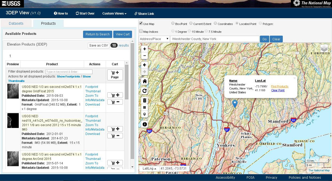
Using the 3DEP Viewer, the author generated a list of DEM datasets which cover the Westchester County geographic footprint.
The NYS ITS GIS Program Office also makes available bare-earth DEMs for various areas of the state via the NYS Orthos Online Viewer . These DEMs were generated from multiple LIDAR collection projects involving a variety of local, state and federal agencies. The office also makes available status maps (PDF) of existing statewide LiDAR datasets as well as in-progress/planned LiDAR acquisition projects. More information on New York State DEM products and activities can be found on NYS GIS Clearinghouse website.
National Hydrography Dataset (NHD)
One of the most visible and well established datasets associated with the National Map viewer is the National Hydrography Dataset (NHD) and the companion Watershed Boundary Dataset (WBD), which are used in tandem to portray surface waters across the United States. The NHD represents drainage networks with features such as rivers, streams, canals, lakes, ponds, coastline, dams, and stream gages while the WBD represents drainage basins as enclosed areas in six different size categories.
NHD products are well documented and include extensive user guides and videos. This year, the USGS National Geospatial Program initiated a new series of virtual seminars to highlight the NHD and uses of hydrographic data. These seminars are intended to share success stories from users who have solved real world problems using hydrographic data, provide information about the National Hydrography Dataset and related products, and provide a virtual forum for users. It is intended the seminars will be presented every six to eight weeks and feature applications and speakers from different disciplines.
For New York State counties, cities, or other political jurisdictions which are not producing large scale planimetric datasets (typically 1”=200’ or greater including hydrology features) through local photogrammetric data capture projects, the NHD provides authoritative hydrologic data as file downloads or accessible via web services at two levels of resolution: Nominally at 1:24,000-scale known as high resolution, and another at 1:100,000-scale known as medium resolution. Also, the USGS has begun producing “NHDPlus” at a nominal 1:24,000-scale using “high-resolution” NHD, the Watershed Boundary Dataset and 10-meter DEMs. The new “NHDPlus” will include value-added attributes, catchments, flow direction and accumulation grids, and flow volume and velocity estimates. The NHD and WBD use a network addressing system based on reach codes and linear referencing to link specific information about the water such as water discharge rates, water quality, and fish population and allows for tracing upstream and downstream .
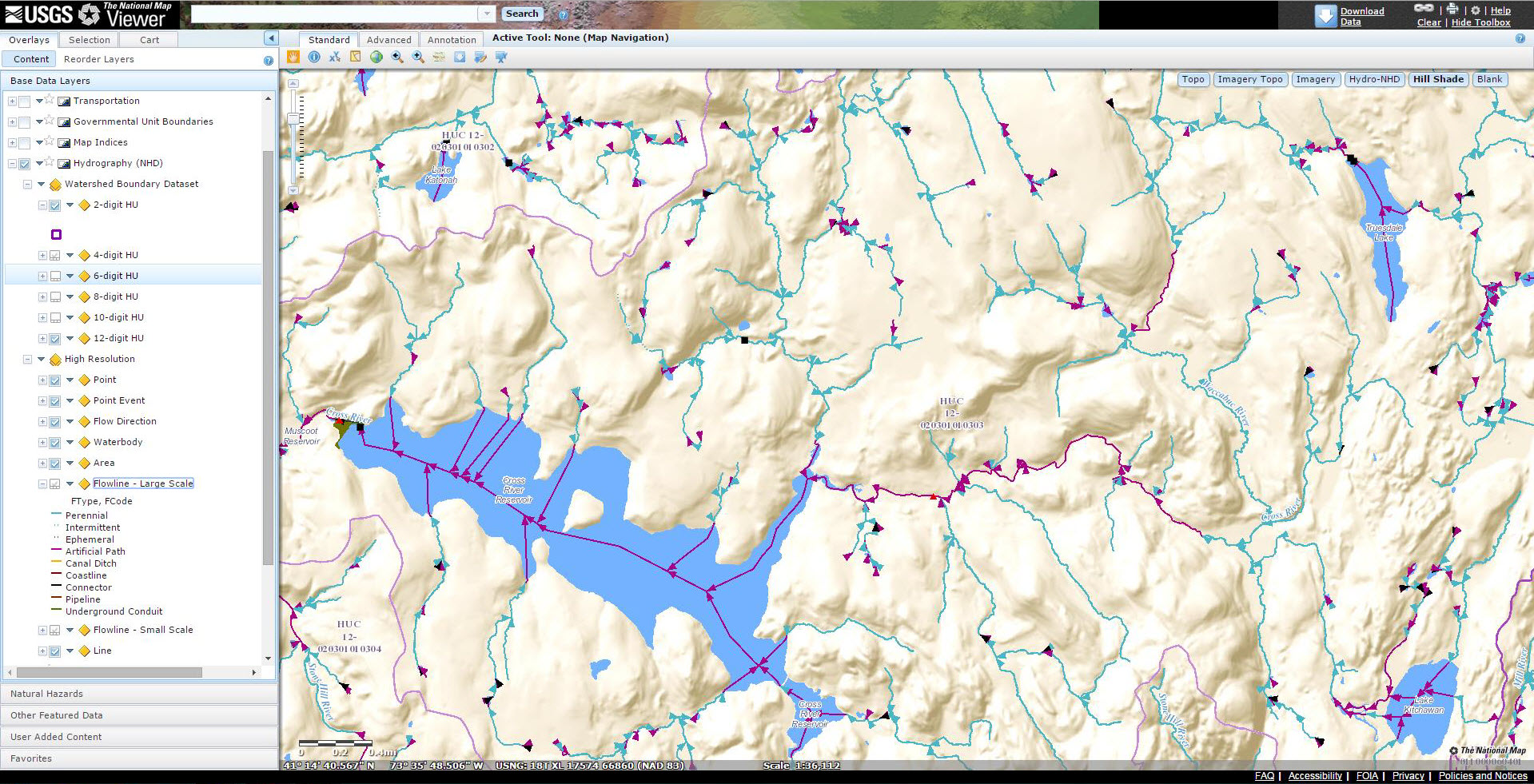
The NHD provides detailed watershed boundary information and several characteristics of flow data at both large and small scales for the entire state. New York State is a designated steward to the USGS NHD program.
New TNM Download Client & Manager
While the legacy National Map viewer continues to provide users with the functionality to download TNM basemap layers (NHD, boundaries, DEM products, land cover, orthophotography, including US Topo and historical quadrangle maps, etc.), a new process has been developed to simplify the process.
The new TNM Download Client and Download Manager, which are now available from the new Data Download and Visualization Services launch page, are new products intended to be used together to streamline the process of downloading products from The National Map. The new TNM Download Client offers a new search experience for all available TNM products. Users can establish an Area of Interest by zooming/panning in the map, drawing a box, dropping a point, or selecting a polygon. One or more datasets may be selected with desired product extents and formats. Preview and Availability layers are provided for datasets to help visualize the content and availability of data.
The TNM Download Manager is a desktop application which allows users to download multiple products without having to click on individual download links. It can load the download links from an order created through The National Map viewer, or links provided from a comma-separated file (CSV) similar to that available in TNM Download Client’s cart feature.
Web Services and Mash-ups
Westchester County GIS has long been both a strong advocate and publisher of map services, recognizing the expanding use and efficiencies of geospatial map services for government and industry. Similarly, many of the layers of data offered in the National Map viewer are also available as an individual (cached or tiled) map service – useful at both large and small scales. Both of which can be integrated into local mapping applications.
The National Map also maintains a series of composite base maps which combine thematic data layers into tile cache services to offer single service base maps with the richness of multiple data sources. If you are interested in digging a little deeper into this topic, How to Use the National Map Services provides good online documentation on how to access and use USGS map services for your online mapping efforts.

Using the ArcGIS Online Viewer, users can “mash-up” map services from different sources. This example includes a WMS service being published by Westchester County GIS (highlighting wetlands in green), storm water outfalls in the Town of Pound Ridge (adjacent the State of Connecticut border), and hydrology flow data from an NHD map service published through the National Map.
Summary
Today, TNM has something for every NYS geospatial user: Government, nonprofits, industry/business, academia, and the rest of the Empire State geospatial playing field. This year several new geospatial products will become available including delivery of lidar collections and US Topos for New York State anticipated in August. USGS authoritative datasets and services can easily augment and provide greater content to geospatial applications available at both the county and state level.
“By providing high-quality National Map and US Topo products, USGS is fulfilling its role as the nation’s civilian mapping agency” notes Doug Freehafer, NYS USGS liaison. In addition to new products and services being provided by the NGP, updates to the USGS member inventory of the NYS GIS Clearinghouse are also planned. The inventory will be changed to reflect new TNM products and services and the hydrologic investigation and data collection being conducted by the USGS NY Water Science Center.
For more information USGS geospatial products and services, contact Doug Freehafer or visit the USGS website.
The author acknowledges contributions from USGS staff Rob Dollison (Reston, VA), Mark Newell (Rolla, MO), and Doug Freehafer (Troy, NY) for their contributions to this article.