Several of my posts over past 18 months have focused on a core set of applications which I have seen evolve over the past three decades that serve as the cornerstones for many New York State local and county government geospatial programs. Increasingly and central to many of these geospatial program areas is the “mobile” component albeit much of the attention to date has been on “field/handheld” hardware and software components for both spatial data collection and updates.
Increasingly it is becoming recognized another mobile collection technology can add value to an organization’s work force and business systems productivity. Originally referred to as Automated Vehicle Locator (AVL) systems, this technology got its start decades ago focusing on the capture (mapping) of a vehicle’s location and display in a GIS or similar digital mapping system. These early systems were expensive and not widely used outside of business and industry.
Over the last five or more years, fleet managers have increasingly adopted “AVL” technology to assist in the management of fleet assets especially with availability of lower cost hardware components which connect to vehicle On Board Diagnostic (OBD) ports. This capability supports fleet managers with a wide range of metrics providing odometer/mileage readings, engine idling, vehicle usage and a variety of other vehicle related information. Now recognized as “GPS Telematics”, this technology has become more affordable and accessible to a larger range of government agencies and organizations. This modern use of the technology centers around the use of M2M (machine to machine) and telematics technologies.
Benefits of GPS Telematics
To date, much of the work focusing on capturing and analyzing data associated with field resources has been done the “old way”, i.e., capturing and recording the data by human fingers. Historically, this method is fraught with inconsistencies. Machine-to-machine (M2M) data capture on average is far more accurate and consistent.
Fleet telematics monitor the location, movement, status and behavior of a vehicle and associated field resources. This is achieved through a combination of the GPS telematics device which is installed in each vehicle transmitting location based data via wireless networks to web servers for near real time availability. Users access location, movement and status information and metrics of vehicles via special web-based software applications or through existing in-house “vehicle tracking enabled” business applications. In essence, GPS telematics systems become platforms to collection and transport valuable mobile resource field information and activities. In addition to locational data, fleet telematics solutions provide the status of each vehicle and by extension the corresponding crew an inference of ongoing work accomplishments and assignments to field resources. Managers know how each vehicle is being used as well as mileage, idling status, location and speed. Such systems can be extended to be connected to onboard systems and sensors which log activities such as street sweeping, plowing, spreading, and spraying – workflows which are particularly challenging to capture and document by hand during the normal course of business. While Return-on-Investments (ROI) can and will vary greatly, calculating the benefits of investing in fleet telematics technology can now be based on factual metrics such as improved routing and dispatching, reducing labor costs, improved fuel and vehicle usage, and newer more cost-effective system architecture (Cloud).
Westchester County GIS LiGO Fleet Management Implementation
Fall 2016, Westchester County GIS initiated a pilot vehicle tracking project with MarshallGIS (Boise, Idaho) using their patented LiGO® telematics technology. LiGO is a GPS telematics tracking solution providing detailed information on the activities of each vehicle and enables users to see real-time locations on a map (Figure 1) as well as providing customized reports on key metrics such as total miles driven (individual vehicles and by department), all vehicle trips, mileage, days of vehicle use, number and average length of time stopped at known and unknown locations, speed, vehicle idling times more than five minutes (or any user defined length of time) and more (Figure 2). Westchester County program managers can now get a new and consistent flow of information and metrics to help manage their field operations and fleet assets.
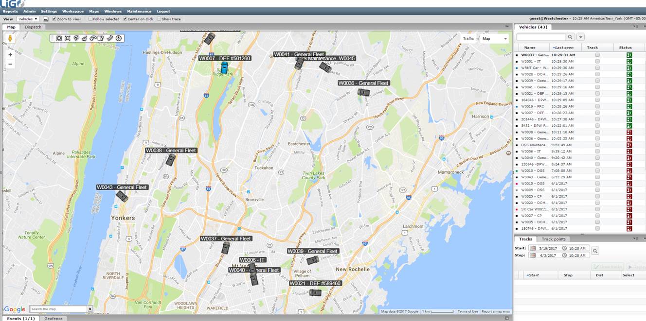
Figure 1. Real Time Location of Westchester Vehicle Assets and Mobile Workforce
LiGO is typically offered as a hosted solution with all computing needs being handled through the MarshallGIS controlled and managed secure hosted cloud servers. However, Westchester County opted to implement the LiGO solution on-premise with and on its own infrastructure which required a minor amount of additional implementation time and onsite professional services from MarshallGIS.
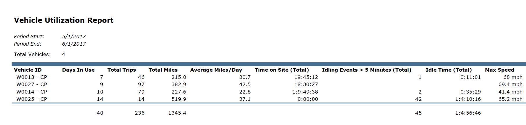
Figure 2. Sample Monthly Vehicle Usage Report
Each vehicle is outfitted with a telematics device. Westchester County currently is using CalAmp LMU-3000 series GPS tracking devices (Figure 3) which is easy to install in the ODB2 port – “plug-n-play” ready. The device gathers data on location, speed, acceleration, and numerous other forms of information which is programmed and transmitted via cellular service back to Westchester County servers for storage in the LiGO® Server software (Figure 4). From here, the LiGO application is published as a secure web application to Westchester County LiGO users and managers.
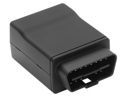
Figure 3. OBD2 Type GPS Telematics Device
While the broad use of hybrid vehicles has lessen the need for governments and organizations to implement specific programs to reduce road mileage and fuel costs, the advancements in telematics technology, such as integration with on-board systems/sensors/controllers, integration with existing enterprise office business systems, as well as more affordable and easier implementation options, have contributed to the growing use of the systems.
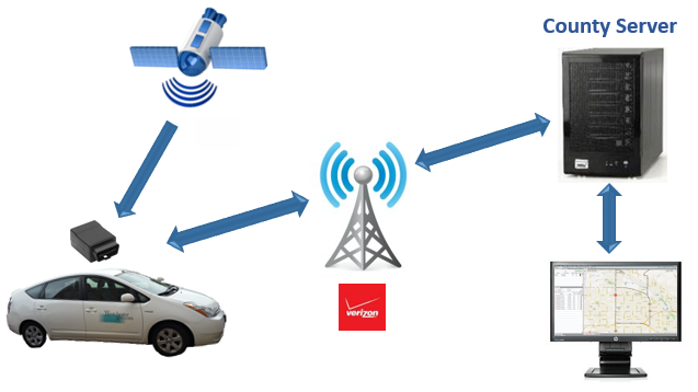
Figure 4. Westchester County LiGO On Premise Conceptual Architecture
Results and Next Steps
The Westchester County pilot project involved an initial 50 vehicles (currently now at 62) across the following departments and program areas: Consumer Protection, Public Works (Road Maintenance), Probation, Corrections, Parks and Recreation, Environmental Facilities, Health, and selected vehicles associated with the central fleet. Vehicle types involved in the initial pilot vary across the user departments including hybrid and gasoline passenger models, dump, utility and pick-up trucks, and vans. MarshallGIS provided free online/web training seminars for the initial user community with ongoing training being provided now by in-house GIS staff as additional departments are added to the program.
User acceptance and use has grown since initial deployment with program managers quickly realizing the benefits of where field resources are located relative to scheduled services and delivery. They have also been very involved in helping design and define the monthly reports which highlight key metrics for vehicles and associated personnel and crews. Given the recognized benefits, the County is now considering additional deployments of the LiGO product in program areas which contract for busing services as well as integration with the County’s enterprise ESRI environment (Figure 5) and Infor work order management systems.
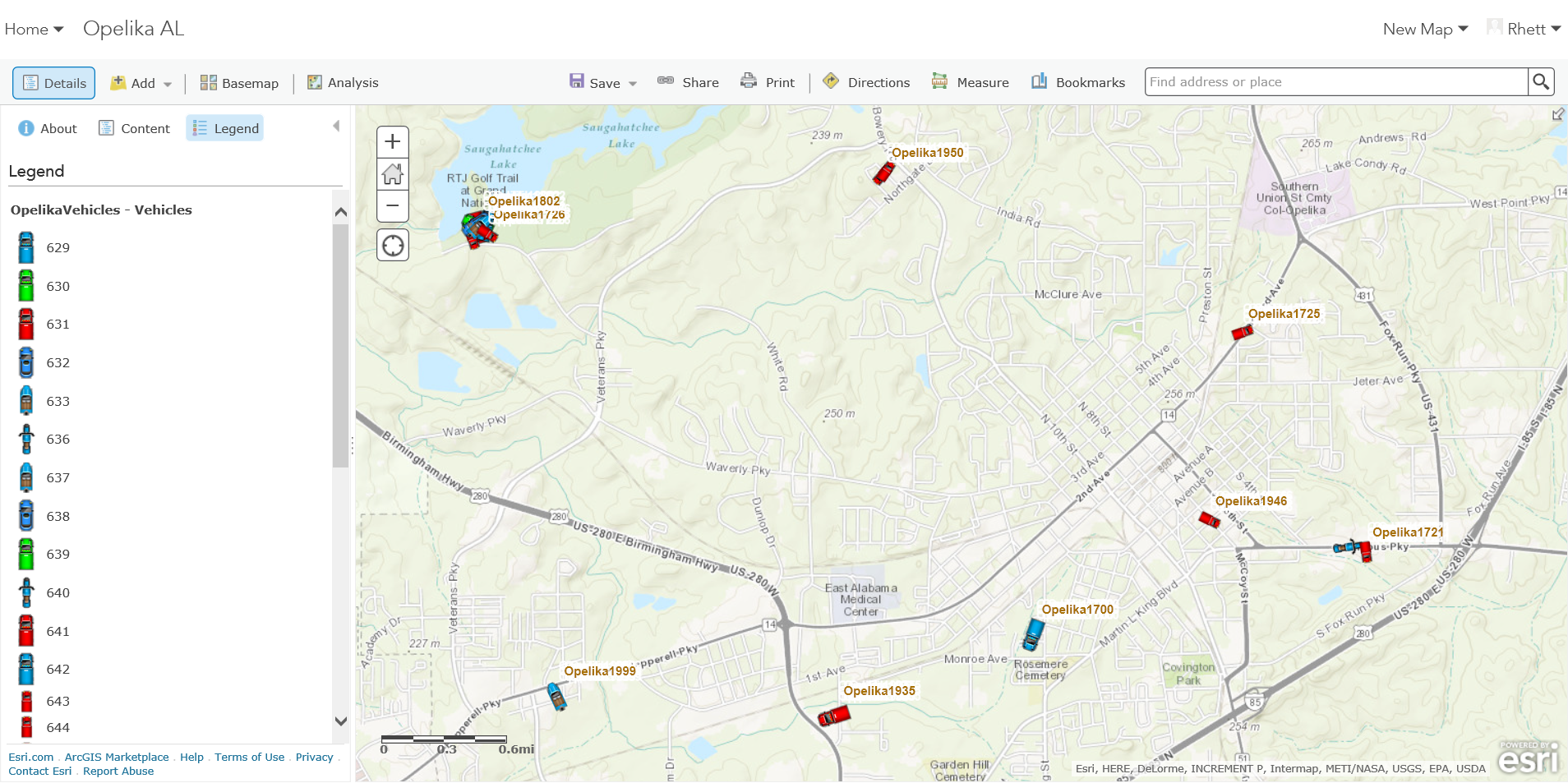
Figure 5. Example of Live Vehicle Locations in ArcGIS Online Operations Map
One of the biggest challenges Westchester County GIS experienced in implementing the pilot vehicle tracking technology was initiating and establishing working relationships with new departments and operational programs. Historically, government GIS programs and fleet management operations have had very little in common. Over the last five years much of the advancement in this technology has been directed by Fleet Managers with limited input from IT/GIS or other department managers. Often, these program managers are selecting systems which are focused primarily on Fleet/Fuel Management and may or may not be used/integrated with the organization’s geospatial applications and other business systems. It is increasingly important the IT/GIS professional communities recognize the benefits and evolution of the technology as an essential piece in supporting all components of mobile and field operations. Since its initial deployment, Westchester County’s fleet management staff has become an integral component of helping support and advance the LiGO program.
This article serves just as an introduction to GPS Telematics technology and Westchester County’s initial use and implementation. There are many more details regarding the value this technology can provide Empire State government agencies with regards to managing its mobile resources. Customer service, dispatching, routing, sweeping, plowing, spreading, spraying, safety are just a few of many individual use cases where M2M GPS telematics can provide near real time information and metrics 24/7.
For more information on the LiGO product, contact Terry Bartlett, Senior Account Executive, at MarshallGIS.