
Over the past six months, there have been a myriad of articles in the online trade publications referencing the growth of geospatial technologies in agriculture. From the growing field of “precision agriculture/ precision farming” or the use of Unmanned Aerial Vehicles (UAVs aka “Drones”) the use of geospatial technology is clearly expanding in the agricultural (crop and fruit) disciplines across the State of New York. There is even the growing field of GeoInsurance which focuses on policy and insurance underwriting covering agricultural lands and programs which are increasingly being viewed as vulnerable due to impacts of climate change and more frequent natural disasters. However, while there is considerable geospatial growth in the agricultural community, it would appear the traditional NYS GIS community has made only limited headway in context of collaborating and advocating use of the technology with this emerging user community. A review of papers presented at recent statewide GIS conferences (2013 NYGeoCon) or past GeoSpatial Summits show only a limited number of agriculture related topics and presenters.
One way to frame the potential for building a closer business relationship with the NYS agricultural community is this: What’s the ceiling for the geospatial technology in one of New York State’s largest industries – covering 23% of the statewide land base, seven million acres, and nearly 36,000 farms? Or the second-largest producer of wine in the nation contributing to over $3.76 billion in economic benefits to the economy of the state in 2008? As well as a means to engage students graduating annually from the SUNY system with Certificate, Associate and Bachelor degrees in Agricultural Business, Agricultural Engineering Technology, Agricultural Science, and Agricultural Technology? And the many agricultural program and research efforts at the Cornell Agriculture and Life Sciences Program (CALS)?
Precision Agriculture: It can be said that the practice of precision agriculture (PA) was enabled by the advent of Global Positioning System (GPS) technology which ultimately resulted in a farmer’s ability to locate precise locations in the field allowing for the creation of maps – based on a common grid for comparison – showing and measuring the spatial variability of variables such as crop yield, terrain features/topography, organic matter content, moisture levels, pH, or nitrogen levels among others. Precision agriculture has also been enabled by technologies like crop yield monitors mounted on GPS equipped combines, seeders, and sprayers – which can have immediate results in reducing overlap and other benefits, not least of which is more timely field work and less operator fatigue. Illustrative of the growth of PA (crops) in New York State is shown in an online article in DairyBusiness.com – with references to the Western New York Crop Management Association and a Cornell University publication (undated) entitled Precision Agriculture Technology: New York State’s Adoption, Adaptation, and Future. Any Google search on “NYS Precision Farming” from the CALS website will generate a long list of articles and examples of PA across the state. Precision Agriculture is also being promoted through the New York Corn & Soy Growers Association. Though certainly not the only other additional references on PA in NYS, other informative articles and URLs include: ESRI’s GIS for Agriculture, the Ohio Geospatial Program (Agriculture and Natural Resources), GPS hardware providers Trimble and Leica, a recent 2013 GCN Magazine article “A Bumper Crop of GIS Maps”, and everyone’s favorite tractor company – John Deere. Precision Viticulture (wine) is also the subject of applied research through the New York State Agricultural Experiment Station.
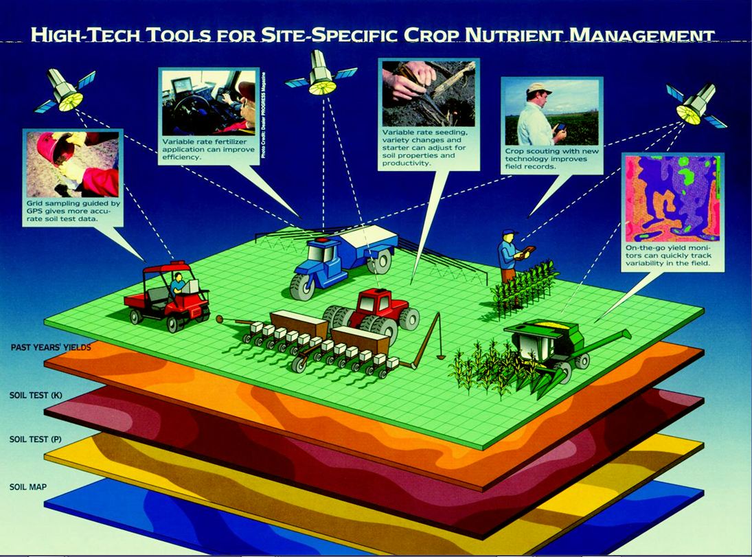
Precision Agriculture includes, GPS, traditional GIS applications, and even Remote Sensing
Unmanned Aerial Vehicles (UAVs): While there is still much debate on the “legal” uses of UVAs (Geospatial-Solutions online articles Nov2013 and Dec2013), UVAs (aka “Drones”) are anticipated to have a dramatic impact on the precision agriculture market as a means to easily capture aerial images for scouting and monitoring crop health such as detecting pests, weeds and nitrogen deficiencies. Farmers will have the ability to know what’s going on with every plant, spotting problems before they spread, and applying chemicals with precision. They’ll use pesticides and fungicides only when needed and in the smallest amounts necessary, lowering the chemical load in both food and environment and saving money. On smaller farms, farmers can get to this level of precision with hand-tending. But larger farms, the answer is more likely to be with the use of drones.
Drones can also be used to locate cattle and their available forage over large areas, measure crop height, and generate topographic maps and models for land leveling and drainage applications. In addition, GPS-enabled drones can store precise X,Y coordinates for pictures taken enabling farmers to stitch pictures together more accurately, getting a better image of what’s happening on the ground. (A much cheaper, quicker, and more accurate alternative than contracting for aerial photography or using lower resolution satellite imagery). While the current generation of drones (Data Drones) are being used primarily in context of collecting information, the next generation of machines will be capable of proactively protecting crops (Protection Drones) from bugs, birds, disease and other unwanted problems. Ultimately it is anticipated that drones will evolve to planting sees then applying fertilizers and herbicides – only in precise locations (Seeding and Harvesting Drones).
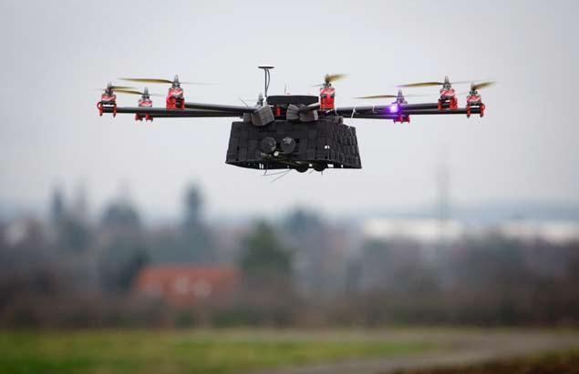
Drones for agriculture come in many sizes and shapes often weighing under ten pounds.
The Federal Aviation Administration (FAA) recently selected the facilities at the Griffiss International Airport, the former Air Force base near Rome, New York as one of six locations in the United States to prototype the development of drones for commercial use. Aerospace firms and universities in New York and Massachusetts will be involved in the research at Griffiss. This bodes well for upstate New York as the Association for Unmanned Vehicles International (AUVSI) report The Economic Impact of Unmanned Aircraft Systems Integration in the United State shows the economic benefit of UAV integration. AUVSI’s findings show that in the first three years of integration more than 70,000 jobs – including an estimated 2,276 in New York alone – will be created in the United States with an economic impact of more than $13.6 billion. This benefit will grow through 2025 when we foresee more than 100,000 jobs created and economic impact of $82 billion. A few days after the selection of the Griffiss site, the first company announced its plans to utilize it for testing. FlyTerra, a New York City firm, is developing drones for use in aerial imaging and terrain data gathering for agricultural and other purposes.
Current FAA rules limit drone operation to under 400 feet and to steer clear of airports and crowds on the ground. But that will change in a couple years as U.S. Congress has mandated the FAA incorporate drones into national airspace by Sept. 30, 2015. But if you want to jump in right now, you can go buy your own drone at Amazon for under $300 (yes – battery included). Even the more expensive and advanced drones which are being prototyped in agriculture are easily controlled using the Apple IOS or Android smartphones.
GeoInsurance: Agriculture is an industry which is exposed significantly to climatic risks, and the insurance industry is increasingly using geospatial tools to help analyze and understand weather patterns and climate as part of insurance underwriting. Remote sensing technologies, in combination with traditional GIS applications, form an integral part of day-to-day risk analysis. Large geographic predictive models focus on drought forecasting, or other natural disasters such as floods, hurricanes, wild fires, and earthquakes. Geospatial tools are also being used in claims management and resolution (and to consider the use of drones in this regard in the future?), mitigating risks, fraud detection, as well as overall decision making. As globalization and increasing catastrophes (both natural and man-made) continue to create risks, more and more complex, geoinformation and location analytics are opening up the insurance industry. The U.S. GeoInsurance Conference “Enabling Geospatial Technology for Risk and Catastrophe Modelling in Insurance” will be held April 8-9, 2014 in Miami, Florida. More information on New York farm insurance can be found at the NYS Agriculture & Markets website.
Conclusion: There is a tremendous upside for the NYS geospatial industry to develop an expanded business and professional relationship with the NYS agricultural community. From the size of the statewide agricultural industry (including both crop and fruit – including the wine industry), labor and work force numbers, consultants supporting the NYS farming industry, farm equipment dealers, emerging UAV and GeoInsurance industries, and higher education academic and agricultural extension training programs – all collectively present a large potential constituency that should be nurtured by the NYS GIS Association. It will take some time, but the long term effect should be fruitful.
If all goes well, perhaps one day at a future NYS GIS Conference or Geospatial Summit, attendees will gather outside the conference pavilion pulling up lawn chairs to watch a drone demonstration – all while sipping on a glass of New York State wine!