
At the 2015 NYGeoCon in Albany, I presented a paper focusing on several GIS applications which often support and justify GIS/geospatial development at the local level. I refer to these applications and program areas as the “GIS Common Core” and it was my intent to use the presentation as a starting point to expand the discussion further as part of this blog.
While some of the GIS Common Core program areas are not new to the discussion, several factors have contributed to elevating these day-to-day GIS functional areas to the mainstay of local government geospatial efforts. Though these factors and opportunities vary greatly across the state, some of the more obvious reasons why “GIS Common Core” applications are becoming the foundation of local government programs include:
- Improved large-scale spatial data integration across key business applications (assessment-inspections-permitting-public safety-utilities)
- Better address standardization as a result of E911 implementation
- Significant improvements on the integration between GIS and AutoCAD technologies
- Establishing capacity to fulfill ongoing/permanent regulatory and reporting requirements (MS4)
- Broad deployment of software programs in which using/collecting/maintaining X,Y data is implicit and available by default; GIS/geospatial is often no longer considered an “optional” feature
- Leveraging flexible, easy-to-use browser-based applications which are accessible in a wide range of environments, particularly in the growing government mobile work force. A work force which expects maps anywhere anytime.
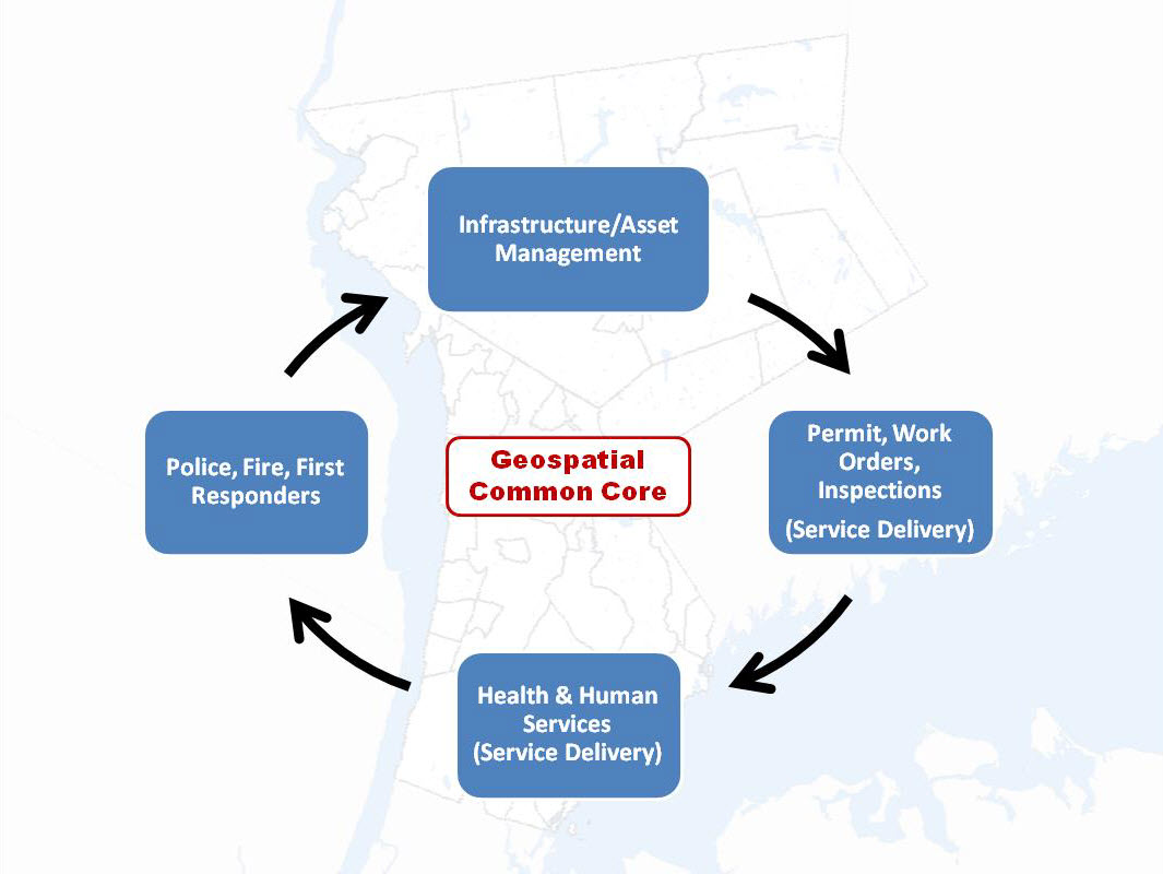
“GIS Common Core” application areas in New York State local governments
And while advancements in the GIS Common Core have been realized in many local governments across the Empire State through 2015, much work is still to be done to truly institutionalize geospatial technologies at the local level. Much of which, to be discussed in the final post of the Common Core series, focuses on local governments unifying and establishing a legislative agenda supported by elected state representatives. An agenda which must separate local governments geospatial development needs from the long standing state level / state government GIS programs and coordination efforts which continue to focus on producing selected products and services, some of which by 2015 standards, are now geospatial marketplace commodities. Meaningful and detailed collaboration by the local government GIS community with professional organizations such as the Association of Towns of New York State, New York Association of Counties, and the New York State Conference of Mayors, all of which having a long and established track record of participating on the New York legislative and political stage, would be a welcomed change of focus.
This GIS Common Core series will review current and local government geospatial priorities in five parts: (1) Infrastructure and Asset Management – which is included in this current post, (2) Permitting, Work Orders, and Inspections, (3) Health and Human Services, (4) Police, Fire, and First Responders, and (5) Schools – though which is not included in the Common Core image above – provides several opportunities for local government GIS expansion beyond the more commonly recognized and ongoing K-12 curriculum efforts.
Part 1: Infrastructure and Asset Management
It’s hard today to pick up a government publication like American City and County or Governing and not see articles focusing on the concerns over the condition of the American public infrastructure. Whether it be roads/highways and bridges (New York State is home to more than 17,000 highway bridges?!) or water, sanitary, storm and drinking water systems – systems all of which are in dire need of rehabilitation across the Empire State.
The focus on the public infrastructure provides great opportunities for NYS local government GIS practitioners to be at the forefront of the inventory, mapping, monitoring/inspection of critical public infrastructure assets. These efforts also include the opportunity for advocating and building affordable and state-of-art mobile mapping applications. Long term funding towards supporting geospatial applications in this area is often more readily available through annual appropriations and earmarked capital budget projects, as well as grant funding. Most New York State water, sanitary, and utility districts fall under the category of “Special-purpose districts or special district independent governmental units” which exist separately from, and with substantial administrative and fiscal independence from, general purpose local governments such as county, municipal, and township governments . Such financial independence provides expanded opportunities for local governments to build sustaining geospatial applications in infrastructure/special district programs which must be maintained.
With the integration of computer-aided design (CAD) and GIS technologies more established, GIS workers at the local level can better position themselves with more established funded engineering and public works programs. As I have noted in earlier eSpatiallynewyork posts, it would behoove the New York State GIS community – particularly NYGIS Association – to build and actively expand professional outreach efforts with established New York State professional organizations in this space such as New York State Society of Professional Engineers (NYSSPE), American Society of Civil Engieners (ASCE), or the New York Chapter of the American Public Works Association. Co-hosting webinars or seminars with these professional organizations at events like NYGeoCon would behoove the statewide GIS community as the focus and attention of the decaying public infrastructure is not going away. Or the related money. Btw – the 83-page 2015 New York State Infrastructure Report Card Grade by the Society of American Civil Engineers: C-
By extension, infrastructure and asset management also includes several related evolving geospatial technologies such as automated vehicle location (AVL), optimal routing and 311/Customer Relationship Management (CRM) systems. Geospatial mobile applications have seen tremendous growth in recent years primarily due to advancements in smartphone technology which is (both the devices and corresponding apps). While the mobile app field is wide open with many commercial off-the-shelf (COTS) and customized programs available , ESRI’s Collector app is an ease-of-entry example for local governments to get started in the mobile data collection arena. One of my more favorite references in this regard is GISCafe’s contributing columnist Matt Sheehan’s recent post: Low Cost, Simple Mobile GIS Asset Management Systems are Finally Here.
Many of the challenges and responsibilities for municipal governments in supporting infrastructure and asset management programs are conceptually similar statewide and provide a framework for local government GIS leadership – working through the NYGIS Association and not through state coordinating or advisory committees – to discuss priorities and funding needs with New York State elected representatives. Such dedicated monies could be earmarked for data collection, consultant support, application development, integration with SCADA systems, conversion/automation of historical manuscripts, or hardware and software acquisition. Infrastructure and asset management is a significant and major New York State local government geospatial initiative. A priority. Permanent, visible and part of the discussion among NYS elected officials and representatives.
A must-have for local government GIS programs.
Next: Permitting, Work Orders, and Inspections