As a hiker myself, I first visited the Finger Lakes Trail Conference (FLTC) website in search of information about the trail system with little knowledge of the incredible structure the organization has in place for creating and publishing hardcopy and digital maps. Thus, the genesis of this article and an overview of how FLTC makes all of the digital content come together.
Background
Established in 1962, the Finger Lakes Trail Conference (FLTC) mission is to “… to build, protect, enhance, and promote a continuous footpath across New York State. Forever!” With administrative offices near the Mt. Morris Dam Visitor Center in Mt. Morris, New York, FLTC is a 501(c)3 non-profit organization which works in cooperation with its members and various organizations to develop and maintain the premier hiking trail system in New York. The Finger Lakes Trail System includes the main Finger Lakes Trail (FLT) from the Pennsylvania-New York border in Allegany State Park to the Long Path in the Catskill Forest Preserve. The main FLT is 580 miles long. There are six branch trails and 29 loop trails and spur trails that extend from the main FLT. These branch, loop and spur trails currently total 412 miles. Including the Main Trail and all branch, loop, and side trails, the Finger Lakes Trail System offers 1,000 miles of hiking. Today, more than 1,400 individual and family memberships currently support the FLTC of which approximately one fourth actively volunteer to operate the organization and its programs. The sale of maps and GPS track data help build and maintain the trail system.
FLTC also recognizes Sponsors which are individuals or organizations which formally accept responsibility for maintaining a length of trail in the FLT System and Affiliates which are hiking clubs and Scout troops that operate their own local hiking program and sponsor (maintain) their section of the trail system. The FLTC is a Partner of the North Country Trail Association (NCTA) and cooperates with that organization and the National Park Service in maintaining and promoting that portion of the FLT that carries the North Country National Scenic Trail. The FLTC is also a member of the Great Eastern Trail Association (GETA) and is constructing a branch trail of the FLT system (the Crystal Hills Trail) that will carry the New York portion of the Great Eastern Trail.

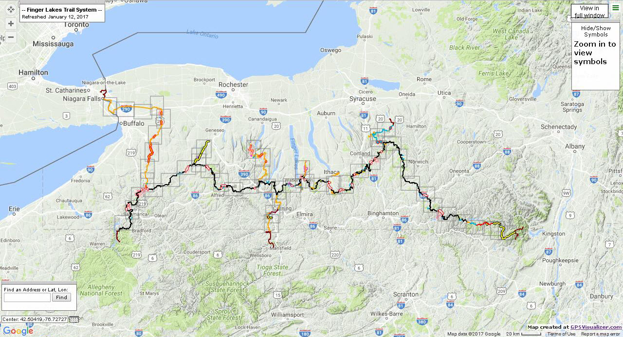
The Finger Lakes Trail System main trail from its eastern terminus in the Catskills to Allegany State Park in western New York State. From their interactive web application this image also show outlines of section maps which provide detail at larger scales.
Mapping and Cartography
Since the early 2000s with advancements in GPS technology and digital data collection, trail mapping responsibilities within the FLTC have been increasingly assigned to the Trail System Management program within the organization. Within this structure, the mapping of new and/or changes to trails fall on the responsibilities of volunteers trained in use of GPS devices – either their own Garmin device or an FLTC-owned Garmin Montana. FLTC maintains detailed specifications on what GPS devices are acceptable and how they are to be configured. The GPX file from the walk is emailed to the mapping team which is currently under the direction of Greg Farnham and Jo Taylor). Following a very detailed process document, the mapping team uses Garmin Basecamp to edit the official, unfiltered GPX track, which is referred to as the “trail centerline”. There is adequate iteration with the person who walked the trail and the Regional Trail Coordinator (RTC) overseeing that section of the trail where the data is being collected to ensure an accurate rendition of the (trail) data has been collected. Regional Trail Coordinators and other FLTC administrative positions are highlighted on the organizational chart on their website.

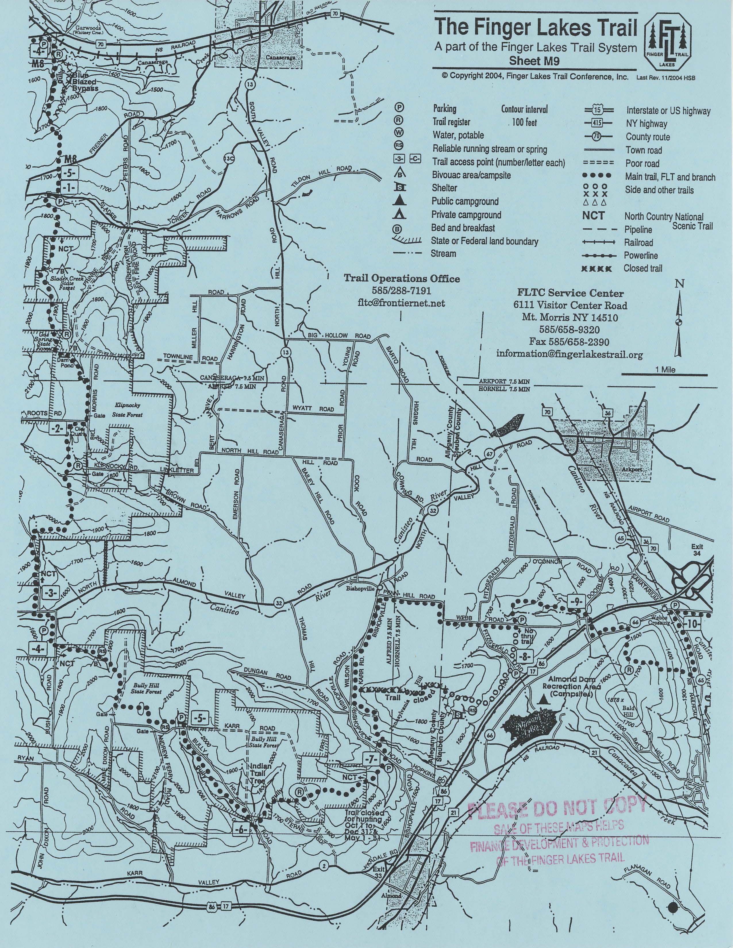
Pre-digital, an example of the old “blue” FLTC hardcopy map
Once the new digital data is confirmed, it is exported from Garmin Basecamp and imported into TopoFusion software to filter the GPS tracks . TopoFusion is then used to convert the data to an ESRI shapefile and imported into ArcMap. The mapping team also modifies the back of the map description (MSWord) based on inputs from the volunteer(s) collecting the data, the RTC, and mileage data from the mapping team. Once all approved, the front and back are joined together and published as a georeferenced PDF from ArcMap. Finally, hardcopy maps are printed in the FLTC office from PDF files on Rite-In-The_Rain© paper and made available for sale from the FLTC website. Other map features such parking lots, camping sites, or water stations are also mapped with the GPS devices though on occasion edited by hand for cartographic reasons to support production of the 1”=1 mile hardcopy map. (I found out along the way that prior to the advent of digital data collection and cartography, FLTC trail maps were originally produced on as “blue” maps as illustrated above. Original FLT maps from 1964 can be found at the Cayuga Trails Club website.) GPS datasets confirmed by the mapping team are ultimately forwarded to the web team for use and synchronization in the interactive web mapping program and the georeferenced PDFs are made available for sale from the FLTC online store for use in GPS devices and smartphones.
All the activity among the FLTC volunteers creates a lot of data. “We currently store and manage between 9 – 10GB of data”, says Farnham, “and we have a proprietary backup scheme in place.” FLTC also maintains hundreds of layers of data such as roads, topography, political boundaries, hydrology, much of which was obtained from public sources such as the New York State GIS Clearinghouse and other local government sources. With regards to the publication of their maps, FLTC will modify/edit public domain data when inconsistencies or actual field conditions are observed. “We feel this is more accurate information for the hiker who may be depending on what is seen on their GPS device display or smartphone for comparison against what is seen “on the ground” while they are hiking”, notes Farnham. However, FLTC never edits or modifies hydrology, topography or political boundaries.

2017 version of a digitally produced FLTC section map: Sheet M33 covering the eastern terminus of the trail system where is connects to the Long Path.
Online Mapping
FLTC added an interactive mapping in 2011 and has been incrementally enhanced since then ”, notes webmaster Roger Hopkins. While there was some in-house familiarity with Google Earth and Google Maps, FLTC settled on GPSVisualizer as its online interactive mapping platform. It is a free utility that creates customizable maps and profiles from GPS data (track logs & waypoints), addresses, or coordinates. Currently FLTC uses GPSVisualizer to provide two online versions of the trail system the Interactive Map (Full System) and Interactive Map (Segmented) which provides users with focused views of the four regional sections of the FLTC system: Catskill, Eastern Finger Lakes, Western Finger Lakes, and Allegany. A third viewer is also available highlighting the 430 miles of the FLTC which are part of the North Country Trail in New York State. Hopkins adds “The GPSVisualizer display format offers numerous options for customizing the display, including which widgets to show and where to them. It also allows control over the styling of the track, positioning and size of waypoint symbols, initial zoom factor and centering. Our internal process for creating the HTML file makes heavy use of these options.”
GPSVisualizer is a map display utility which can convert and render a variety of data formats on different map backgrounds. FLTC converts the GPS files to a HTML file which includes calls to the display software on the GPSVisualizer server – resulting in the interactive maps which are found on the FLTC website. The FLTC coded HTML files never leave their website (hosted by BlueHost) whereas the display software remains on the GPSVisualizer server resulting in thousands of maps being displayed every day. Another impressive piece – or utility – in the production and publishing of FLTC online content is the use of a macro-enabled Excel workbook developed in-house. GPSVisualizer is a perfect fit for FLTC given their focus on the collection and maintenance of GPS datasets. And along the workflow, the many committees and working groups within FLTC use Syncplicity to support secure file sharing.

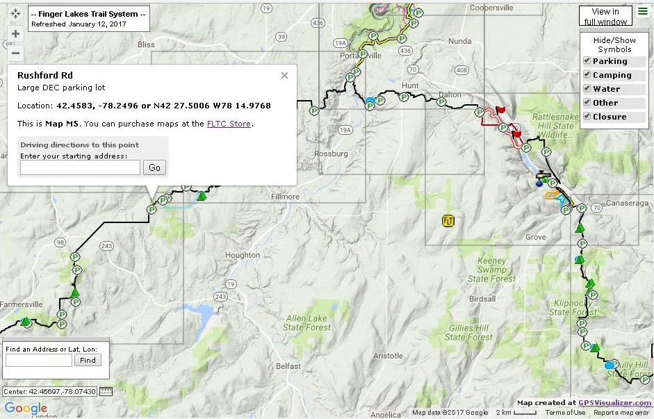
From the online interactive map highlighting an area near Letchworth State Park in western New York State. Note the availability of pop-up boxes when clicking on a map feature. This image also includes symbology showing the locations of parking areas, camping spots, and trail closures.
Summary
After landing on the FLTC website looking for maps and information on the Finger Lakes trail, it didn’t take me long to see there was a lot going on behind the scenes in terms of geospatial technology (specifically GPS). I personally have not seen any FLTC make any mapping related presentations at any statewide GIS meeting or conference over the past several years. Though after communicating with several members in putting this article together and learning how they manage the collection, management and publishing of digital data – all within a volunteer driven organization framework – I would suggest more than just one “team” within FLTC has a message which would be beneficial to similar non-profit geospatial organizations across the New York State GIS landscape. While their use of GPSVisualizer in publishing web content is unique and outside the norm of many current statewide internet mapping interfaces (i.e., ArcGIS.com, OpenStreetMap, Google Maps), their day-to-day handling of the geospatial data and workflows are conceptually similar to likes of larger government GIS programs: Documented Data Collection Processes – Data Scrubbing/Validation – Data Management – Desktop GIS (ArcGIS) – Cartography – Hardcopy Map Production – Programming – Web Applications. And their cartographic products are impressive – which can generate up to 10% of the organization’s annual income according to Executive Director Quinn Wright.
And underneath it all, promoting hiking, conservation, and enjoying the great New York State outdoors. Kudos to the FLTC organization of integrating geospatial technology and mapping concepts to support their day-to-day business needs. Visit the FLTC website and take a look for yourself. Fill up a shopping cart worth of products, support the FLTC, and hit the trail!
