Warren County GIS: A Showcase of Geospatial Content for County and Local Government

Program’s modest beginning started in the late 1990s with AutoCAD files and a copy of ArcInfo

Now spending a significant amount of time upstate New York in Essex County, we now find ourselves looking for different routes to take back and forth from southeast New York State instead of the “go-to” I87/Northway option every time.  Just to mix things up – the four-plus hour drive going the normal route can get to be a bit monotonous.

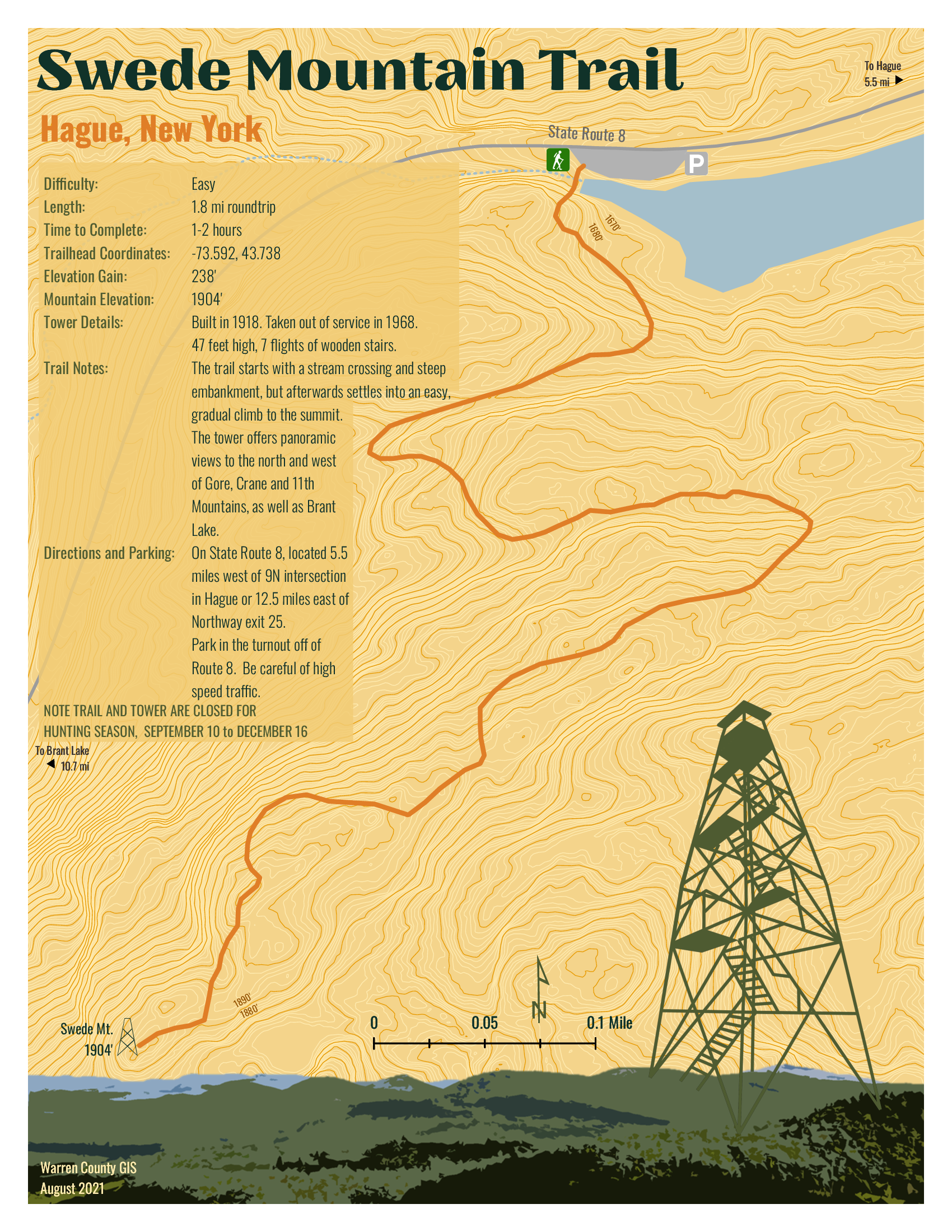
So it was in September I came south out of Ticonderoga headed to Hague (yes, named after The Hague in the Netherlands) on the northern end of Lake George – an area I had never been to.  And it did not disappoint.  Though ultimately to State Route 8 (aka Graphite Mountain Road) to a new Adirondacks trailhead:  Swede Mountain Firetower.  Even though the round-trip hike isn’t that long and relatively easy, it was getting late and I didn’t even get out of the car while in the trailhead parking lot.  Instead, making a note to print out a trail map when I got home.  A couple days later and not having a clue what trail maps were actually available, I Googled “Swede Mountain Firetower trail map” and a candidate list of URLs and image options were immediately returned.  Randomly selecting the one below,  the cartography caught my eye and I quickly looked for the map’s author.  There on the bottom left:  Warren County GIS.  

It was quickly then off to the Warren County GIS website.  Which became the genesis of this article.

Warren County GIS
Just by coincidence, this article coincides with the release of the new Warren County GIS Hub as announced by long-time county GIS Administrator, Sara Frankenfeld.  Overseeing a countywide GIS program judiciously developed over the course of more than two decades – from the days of ARC/INFO coverages to 2022 mobile field apps and interactive online viewing applications.  Also available through the program and Hub is a rich repository of dozens of hardcopy maps available for download covering areas such as countywide outdoor recreation, history, demographics, municipalities, planning and the environment and much more.   An amazing amount of content bundled into three main categories:  Web Maps and Apps | Maps for Print | Download Data.

Background

Originally from the northside of San Francisco Bay in Marin County and earning a degree in Geography from Northern Arizona University, Frankenfeld came to the east coast to initially start work with Dutchess County.  After a short stint with NYSDEC she ultimately made her way to Warren County in 1999 where she got started with a copy of ARC/INFO on a standalone computer in the county building basement.   The county had created a new GIS position in the Planning Department to help convert the tax maps to AutoCAD and then over a period of time converting from AutoCAD to ARC/INFO and then later to geodatabase. 

Over the next four years, she was successful in winning over several other departments on the value and usefulness of GIS technology which she accomplished by focusing on easy, visible “wins” such getting people to use the newly available digital tax parcel data (linked to the RPS data) as quickly as possible and making hardcopy maps.  Lots of maps.  The visibility of the Warren County program also expanded by her working with municipal government zoning administrators and assessors and providing access to the new digital parcel data and including zoning maps,  wetlands data, and FEMA floodplain maps.  A New York State Archives and Administration (SARA) grant enabled the development of a parcel viewer app sby AppliedGIS – where she would later go to work for several years – called the Spatial Data Viewer.  The groundwork was also laid for the implementation of ArcIMS and Imagemate Online.  Somehow she also found time to include outreach programs to local schools and GIS Day.  

After a period in the private sector with (then) AppliedGIS/Fountains Spatial, she returned to Warren County in 2013 where she remains today.  

Today’s Environment

In 2022, the Warren County GIS program is built totally around the ArcGIS Online (AGOL) environment.   Frankenfeld states AGOL has “totally transformed the workplace” and furthers her two main goals of (1) improving public access to data and (2) streamlining/improving processes for county departments and organizations the GIS program supports.  She, along with GIS Specialist Amanda Beck, have embraced StoryMaps, Dashboards, Hubs and Survey123 in ways to make it easy for non-tech users to create and maintain data and access it.  While many of the combo Survey123/dashboard applications are internal facing, others, like the Lake George Milfoil Harvesting real-time app is available to the public.  And so is the Capital Improvement Project Planning viewerBoth respond to GIS requests from local municipalities, local organizations including  the Adirondack/Glens Falls Transportation Council (AGFTC), Lake George Park Commission and the Lake Champlain Lake George Regional Planning Board – all of which have tech support contracts the County.  Projects range from data compilation to hardcopy map preparation to creating and supporting online apps.  Usually these three organizations know exactly what they want, but GIS staff we do often try to suggest ways to streamline or improve their requests.  For example, County GIS staff helped AGFTC come up with a method to inventory sidewalk/crosswalk/curb ramps for ADA transition plans that proved really popular and resulted in a training session for all the Metropolitan Planning Organizations (MPO) in the state.
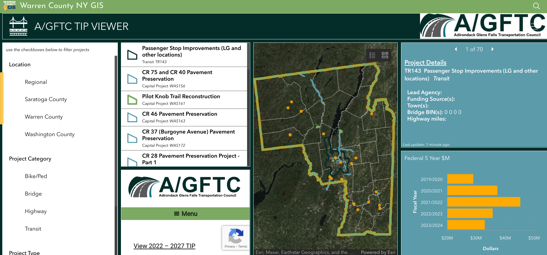
Dashboard for Adirondack/Glens Falls Transportation Council’s Transportation Improvement Program projects.

Having transitioned to ArcGIS Pro to support data editing, cartography and more complex analysis, Warren County GIS staff do a majority of their work in AGOL which includes the mobile pieces Field Maps and Survey123.  They still collect GPS data as needed (usually related to recreation or e911) and support field operations, such as collecting milfoil harvest or infrastructure data, for other users.  They also have Trimble boosters and cell phones which can be checked out to both county staff and municipalities for field data collection along with field worker licenses.   While there are still a few remaining ArcGIS desktop users, most users are using AGOL with named users in Planning, Soil and Water, Public Affairs, the Sheriff’s Department, Office of Emergency Services, Public Works, and Parks and Recreation.  Address and road centerlines are uploaded to the state twice a year and parcel data once a year.  A large current project Sara and Amanda are currently working on is building additional GIS capacity and functionality in County Department of Public Works.

Except for Queensbury which has its own full-time GIS staff person, Warren County GIS supports all municipalities in the County.  At the beginning of the program, Sara had  set up each municipality with desktop GIS as well as providing training and support.  In hindsight and it comes as no surprise this desktop support  was the most time consuming element of her job in the early years.  With the advent of online GIS, County staff has transitioned most of the towns off of desktop GIS, although there are a small number of towns which still use the desktop client.  Most local communities across the County now utilize new AGOL applications.   “We often will take the initiative with projects for the towns that relate to work the County Planning Department is doing such as the Warrensburg buildout analysis“, notes Frankenfeld, “as well advocating the adoption of Field Maps for maintaining water and sewer data.”

New GIS Hub

As noted previously, the new Warren County GIS Hub contains three main areas of content:  Web Maps and Apps | Maps for Print | Download Data.  Each area is then broken down further thematically into categories such as recreation, environment, transportation and infrastructure, planning and zoning, history, citizen reports and more.  With an established user community in County government, most of the time departments and organizations now approach GIS staff directly with applications to develop to support their business needs such as the Safe Pace, Opioid Dashboard, Storm Reporter, TIP viewer, etc).  Other projects have been initiated by GIS staff themselves such as the covid hub and election polling locator.   GIS staff work frequently  with other Planning Department and and apply grant funding to create projects such as History Mapper and the letterboxing challenges (Letterboxing Trail and Historians’ Challenge).
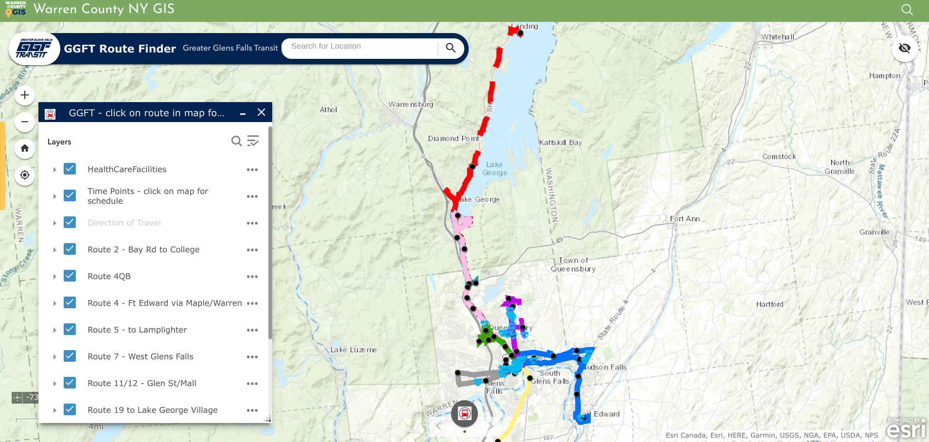
Geospatial viewers are excellent for publishing public transportation systems content. In addition to making time tables and schedules available, ones such as the GGFT also include important public sites such as health care facilities.

Today the COVID Hub is the most popular app though much simplified from early COVID and no longer maintained by the GIS team.   It’s had around 1.5 million views  since its inception in April 2020 – not bad for a county with a population of 64,000   The next most popular is the parcel viewer app (Community Map), which gets about 12k views a month.  After that, the First Wilderness website (about 7k views a month) and the Recreation Mapper which gets a couple hundred views a day, higher in the summer.  Warren County’s primary industry is tourism and is an outdoor recreation destination, so trail maps and recreational resources are popular content and Sara and Amanda spend a substantial amount of time creating and maintaining recreation data and providing access to it.
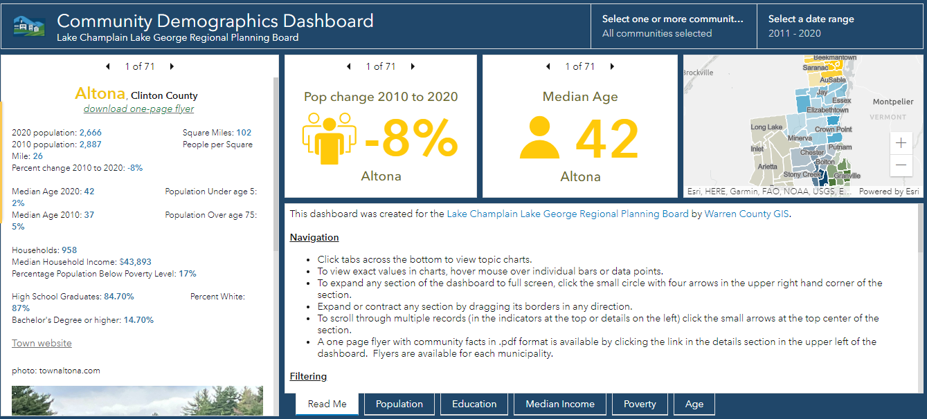
Warren County GIS provides technical support to the Lake Champlain Lake George Regional Planning Board which extends beyond the Warren County footprint. This viewer contains both American Community Survey and 2020 Census data for areas in the five north country counties covered by the Regional Planning Board

Though the application was closed in August, another public facing app focused on the American Recovery Plan Act (ARPA).  Survey123 was customized to create an application for those organizations interested in applying for ARPA funding.  The applications were made available to committee members for review through a Dashboard, and scoring was completed using another Survey123 form.
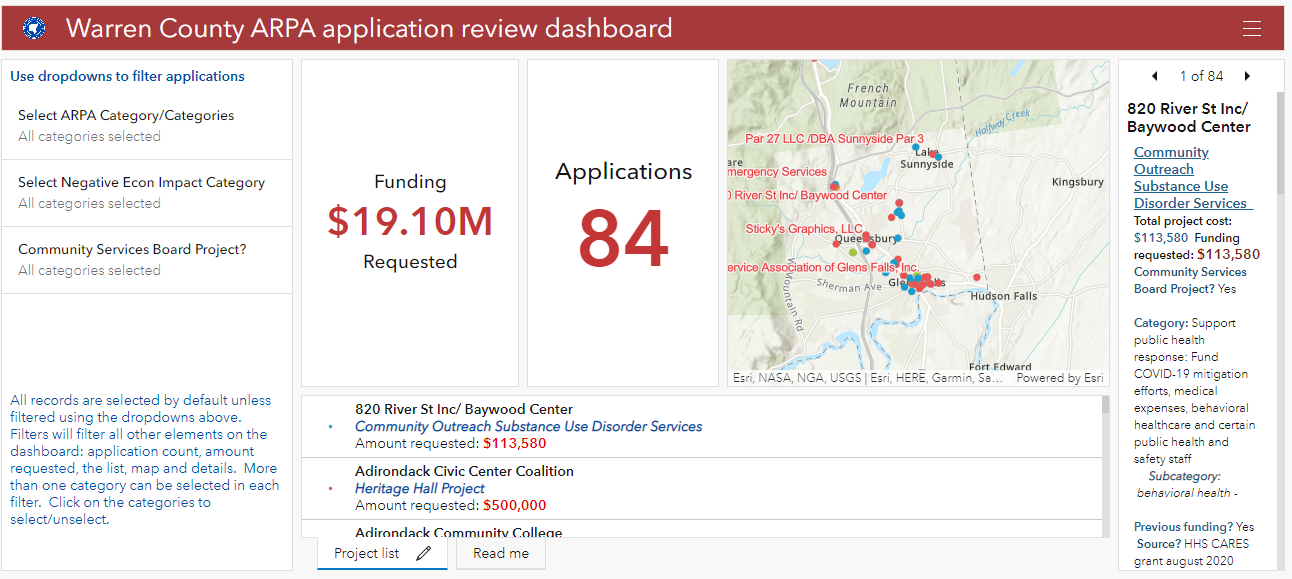
American Recovery Plan Act (ARPA) grant monies provides funding for investment in a wide ranges of community programs and services including geospatial efforts in the rehabilitation and mapping of infrastructure systems.

Sara’s Law

There probably aren’t many geospatial professionals working today across the Empire State that are familiar with Sara’s own little piece of New York State GIS history.  The year was 2002 and it was during her first stint with Warren County.  While using a GPS unit to map the locations of fire hydrants in the North Creek area, she was “challenged” by the professional surveying community of mapping features in a manner/way she was not qualified to do so.   Her post to New York State GIS listserve at the time describing the events read:

“In January, I(Sara) was contacted by an investigator from the New York State Education Department’s Office of Professional Discipline.  They had received a complaint from a surveyor stating that I was surveying without a license.  I was using a Trimble Pathfinder Pro XR GPS unit to collect fire hydrant locations and then plot them on a reference map.  Two investigators met with myself, our planning director, and our county attorney.  The investigators were unfamiliar with GPS and GIS and were basically on a fact-finding mission.  The investigation has progressed, and today we met with the two investigators, an attorney from the Office for Professional Discipline and a surveyor from the New York State Board of Licensed Engineers and Land Surveyors.  The state’s attorney told us at the beginning of the meeting that after reviewing the facts in the case, they do feel that we are guilty of practicing surveying without a license.  She then gave our county attorney a chance to state our case, which I thought he did very well. We were informed that the board will make a decision within the next week.”

At the time, it WAS a really big deal in the statewide geospatial and surveying communities – particularly New York State Association of Professional Land Surveyors (NYSAPLS) and the subject of much discussion and debate.  Significant in that it marked, for the first time, the visible intersection of emerging GIS/geospatial technologies and the professional discipline of surveying – and by extension, engineering in New York State.    While legislation (A01927 & S04396) was proposed in the 2007/2008 timeframe looking to “enhance the definition of land surveying with current standards and tools, i.e., GPS”, nothing was ultimately passed.  And along the way over the course of several years, the discussion and the proposed legislation became known as “Sara’s Law”.  

Little did she know the backpack GPS unit she was using in 2001 in North Creek would one day be the beginning of bringing these different, but similar geospatial technologies together as they are today.   Sara’s place in NYS GIS lore is secure.  

Summary

In addition to the broad presence the Warren County GIS program has throughout county government, it also represents the great relationship and guidance county geospatial programs can provide and offer to local governments.   Local governments that often have both limited financial and technical resources can benefit greatly from county GIS which have technical expertise and infrastructure in place.  A model that can be replicated in other areas across New York State.   

Contact

Sara Frankenfeld
GIS Administrator
Warren County GIS
Warren County Municipal Building
Lake George, NY 12845
frankenfelds@warrencountyny.gov
518-761-6410

10 Questions: Neil Curri

Geospatial technologies are found in so many organizations and on so many levels.
What once was a fledging technology based on desktop client software now
encompasses web technology, mobile and handhelds, increasingly the engineering
software toolbox, and hordes of geospatial data of all types and quality. And yes, the
ageless desktop clients lives on. It’s not often to find someone who is able to navigate
the many pieces of the technology for multiple organizations.

Neil Curri, who lives in the mid-Hudson River Valley community of Lloyd, is involved in a
wide range of geospatial efforts encompassing a diverse number of organizations over
the past several years. While technically currently employed by Partridge Venture
Engineering, Neil also serves as a GIS Academic Computing Consultant at Vassar
College in Poughkeepsie and has served in local government geospatial efforts as well
as the Dutchess County Cornell Cooperative Extension.  We recently communicated to discuss his past and current GIS contributions to the profession.

eSpatiallyNewYork: Let’s go back to the beginning – when and how did you get started
with geospatial technology?

Curri: After working in IT for a few years after college, I decided to go back to school to
refocus my career on something in the environmental field. GIS seemed a logical fit. I
found an Environmental Science M.S. program that also offered a GIS certificate at the
University of New Haven. The summer before I went back to school, I got a hold of a
copy of ArcView 3.2 and made a couple of maps and a website for a local watershed
group. The environmental applications were obvious.

eSpatiallyNewYork: In your capacity at Partridge Venture Engineering (PVE), what kind
of GIS applications or tools do you use?

Curri: Mostly ArcGIS Pro (and ArcMap for legacy projects – still transitioning…), some
GPS, and some limited drone work. We’ve used ArcGIS Online for a handful of projects
where a web mapping application was an appropriate deliverable for the project and
client. I’ve had to build a couple of small databases to organize environmental data
streamlined for mapping. My position is within the company’s Environmental division,
and there’s a need for map figures in every phase of a project – most of our work is site investigation and remediation. Mapping-grade GPS provides enough accuracy for ourpurposes, but we do use differential GPS and post-processing to get the best accuracy we can with our hardware. We’ll collect drone photos when existing aerials are
insufficient or outdated. I’ll either georeference them for any site figures we need, or
occasionally I’ll set up a flight plan and use drone mapping software to get a composite
aerial of a large area or use the 3D capability to estimate soil stockpile volumes or
excavation pit volumes.

eSpatiallyNewYork: You are the GIS Lab Manager at Vassar College. What does this
involve and some of your duties

Curri: My official title at Vassar is GIS Academic Computing Consultant. Duties include
mainly instructional support – advising faculty, staff, and students interested or engaged
in using GIS for teaching and research. For example, students in a Geomorphology
course were recently working on a GIS lab exercise that involves mapping changes in
glacial lake levels and creating an elevation profile to get channel dimensions and
calculate flow volume. This lab is one of several exercises for the course that were
originally written for ArcMap, which I migrated to ArcGIS Pro. I also work with the
college’s IT department staff to maintain GIS hardware, software, and licensing. CIS are
technically the “lab managers”, but we work together to keep things running and provide
capacity as GIS use grows on campus. With an enrollment of about 2,400 students,
Vassar is a small college. But GIS use is reaching the point where I think the
administration will expand licensing campus-wide for the next academic year, which will
significantly reduce the time I spend managing ArcGIS Online accounts.

eSpatiallyNewYork: Any particular area students seem to be most interested in in
applying GIS technology and concepts?

Curri: While the two core GIS courses – Cartography and Spatial Analysis (I
occasionally adjunct instruct either of these) – are taught out of the Geography and
Earth Science department, many students who take the course are Urban Studies
majors, who are very interested in social justice issues. But there are also many
Environmental Studies students who take the courses, and they tend to be interested in
ecological research and conservation. Neither of these courses (nor both of them
together) necessarily prepare students for a career in GIS, but students who take these
courses are sought after by faculty and staff for research and other projects (like the
Poughkeepsie Natural Resource Inventory or research projects at the Collins Field
Station on Vassar Farm) and they are more likely the ones who will pursue GIS as a
career and/or go on to graduate school to study GIS or a GIS-related field.

eSpatiallyNewYork: Tell us something about Vassar GIS students/grads,
YouthMappers, and Society for Conversation GIS

Curri: Hudson Valley Mappers is the Vassar-based chapter of YouthMappers, an
international organization supported by USAID. Two former students, one of whom now
works for USAID supporting YouthMappers, began the chapter in the Fall of 2018.
Students involved in HV Mappers are passionate about using GIS as a resource for
communities, both locally and around the world. The group coordinates local community
mapping events, usually involving some field data collection and partnering with one or
more local organizations, as well as organizing mapathons in which students participate
in Humanitarian OpenStreetMap Team (HOT) mapping projects

eSpatiallyNewYork: What was your geospatial roll and contribution with the City of
Poughkeepsie Natural Resource Inventory?

Curri: I mentored several student workers who assembled the maps created for the
report and online content and I ended up editing some sections of the report with Jen
Rubbo, Director of the Environmental, who led the project. Part of the it involved
inventorying and inspecting Ash trees for impacts by Emerald Ash Borer. I worked with
students and staff using previous tree inventory data by the City’s Shade Tree
Commission as the starting point, set up an ArcGIS Collector project for the field data
collection, and helped organize the information into a public-facing web map. That data
was used by the City to identify trees that presented a potential hazard and remove
them. There’s a short video describing that part of the project on the City’s website.

eSpatiallyNewYork: You worked at Dutchess County Cornell Cooperative Extension
between 2007-2015. What is your involvement there today?

Curri: I was recently asked to serve on an advisory committee for Dutchess County Cornell Cooperative Extension’s pending update of the County’s Natural Resource
Inventory. I worked on the last revision several years ago while at CCEDC, which was
an update of the previous version conducted in 1985 by the County’s Environmental
Management Council. A former intern and a volunteer I mentored there both went on to
graduate school and made careers for themselves in GIS – one is now with the NYS
GIS Program Office and the other is on staff at CCEDC.

eSpatiallyNewYork: You currently serve as Chair of the Town of Lloyd Environmental
Conservation Committee. What’s your sense of the understanding and acceptance of
GIS concepts by citizen and community groups at this level in the Hudson River Valley?

Curri: Though I may not be totally sure, but I think most citizen and community groups
in the Hudson Valley – at least any that have an interest in environmental conservation,
planning, or community development, or anyone volunteering for a town committee or
board – have some sense of what GIS is and that it has value. But there is a lack of
capacity available to citizen and community groups, and consultants like me cost
money, and budgets are limited, so I think exposure to GIS and understanding how it is
or could be useful to them is still limited. Lloyd is one of few towns in the Hudson Valley
with some in-house capability, which predates my involvement.

eSpatiallyNewYork: Some of your community outreach work and involvement has led
to having the DEC Hudson River Estuary Program support an intern on one of their
funded projects. Tell us about how that developed.

Curri: A former student should get some credit for this. While we were finishing up the
Poughkeepsie NRI, she was taking the web mapping class, which is a half-semester
class taught occasionally taught by Prof. Mary Ann Cunningham. Mary Ann connected
her with us, and for her class project the student published the NRI layers to ArcGIS
Online and assembled them in nested web apps to combine functionality. Volunteers
working on NRI’s in two other Hudson Valley towns, Union Vale and Gardiner, saw the
Poughkeepsie online map and wanted one of their own. Interested interns came forwardand used the Poughkeepsie NRI map as a template to assemble those. Based on thesuccess of these, the DEC Hudson River Estuary Program then contacted me to inquireabout assembling maps for the Town of Gardiner’s Community Preservation Plan
(CPP). We found an interested student but it ended up being more simple for PVE to
assume the contract and hire the student. He and I are working on this project now.

eSpatiallyNewYork: What’s been your involvement in statewide GIS activities?

Curri: I’ve been a member of the NYS GIS Association for a few years, but not very
active.I used to attend NEARC regularly before my partner and I started a family five years ago. About two or three years ago, some folks from a few land trusts in the
Hudson Valley started up a local chapter of the Society for Conservation GIS. I have
missed only one or two of these meetings since then. It’s a great group of people and I’dlike to be more involved – after this semester is over!

eSpatiallyNewYork: Have a particular GIS project you worked on or produced that
would like to highlight or brag about just a bit?

I think I’ve already done some of that here, but I’ll mention getting to work with Vassar
Professor Emeritus Dan Peck on the maps for his book, Thomas Cole’s Refrain.

There’s some work for litigation projects at PVE I’d like to highlight but not permitted top
do so. Most of my projects I don’t really consider “produced” by me, as I am often
working with a subject matter expert, a geologist, a professor, or enthusiastic student, a
client, or community partner who’s more or less guiding the project, and I’m just figuring
out what geospatial product or tool fits their needs.

Contact:

Neil Curri, GISP
GIS Analyst, PVE, LLC
Vassar College Academic Computing Consultant
necurri@vassar.edu | 845-437-7708 | 845-664-2100 (mobile)

10 Questions: Peter Carlo

From my level, it’s a rare occurrence any more running into someone in the geospatial field when I can make reference to Arc/INFO and AML (ARC Macro Language) without him or her giving me a big blank stare. A testament to how long we have both been around.    One of those individuals is Peter Carlo, who works for the New York City Department of Parks and Recreation in the forestry division having worked in the geospatial field for over thirty years.  Yes, learning the ropes at the dawn of GIS with command line Arc/INFO and one of the most senior GIS professionals in the vast New York City government GIS user community.  I was fortunate to catch up with him recently to discuss some of the highlights of his long career in the Big Apple.

eSpatiallyNewYork: Maybe a little of your background and where you are originally from?

Carlo:  I was born in the northern Bronx.  In my early years, the family moved to southern Vermont.  After graduating high school I briefly attended Castleton College in Rutland, VT, though eventually returned to New York City to attend Lehman College in the early 1990’s and enrolled in the geography department.  Since then I’ve lived in a couple places in the metro-NYC area but now live with my family on Long Island.

eSpatiallyNewYork:  What is your current responsibility(s) with NYC Parks Department?

Carlo: I am currently the GIS Supervisor at NYC Parks I.T. division.  Our team is made up of  six GIS specialist and our primary goal is to administer the Parks GIS central geodatabase and to support geospatial projects throughout the Agency.  These projects range from configuring Survey123 mobile data efforts to writing data ETL’s (extract/transfer/load) to our central data warehouse.

eSpatiallyNewYork: So geography at Lehman College in the early 1990s.  Where did it go from there?

Carlo: Yes, I really found the passion for GIS technology at Lehman College.  In 1991 or so I had the opportunity to build an ESRI “enterprise” GIS at the GIS lab at Lehman.  Everything from backend data to an ARC/INFO front end access.  I found a passion in setting up hardware and software solutions while configuring components like digitizing tables and then spending hours digitizing contour maps of the Bronx geology.

Soon after graduation from Lehman, I was hired by the NYC Parks Department Forestry Division and started working on the (first) 1995 street tree survey dataset, which was done by associating a tree location with an street address.  At that time, the Parks Departments Forestry offices where located in each of the five boroughs and were managing their own tree data in a disk operating system (DOS) program called Tree Manager.  I also worked with the Parks I.T. Division to setup the our first central geodatabase using SQL Server and ArcSDE.  Working with Lehman College interns we were able to map out all park athletic facilities, playgrounds and comfort stations.  This data still serves as the foundation for the Parks geodatabase.  (Editor Note:  An entirely different read on its own is the effort behind the New York City Street Survey program.  The most recent 2015 tree survey, which is coordinated by NYC Parks,  inventoried nearly 700,000 trees in the five boroughs.  Read here for more details.) 

eSpatiallyNewYork: In this capacity what are some of your current projects?

Carlo: We are currently working with our Forestry division to deploy an interagency Survey123 application that will be used during storm events.  It will be the second version of this solution.  The application will stream 311 hazardous tree request (like tree downs and limb downs) to potentially over 300 field inspectors made up of Parks, FDNY and DSNY staff to name a few. A large part of our work is making our GIS data interoperable with legacy software/data solutions.  We also participate in integrating spatial data and functions into new business and software solutions.

eSpatiallyNewYork:  Do you have a “favorite” GIS project you’ve worked on while in the NYC Parks department?

Carlo:  I would say working (about 10 years ago) on Forestry’s first mobile storm response application.  It was called Storm Mobile.  It worked on the thick IBM Toughbook tablets utilizing wireless and GPS technology, 311 integration and data from the 2005 Tree Census. That was all new stuff for us and everything worked just fine.  I made some lifelong friends during that experience and learned so much.  A majority of our mobile application use smart phones and tablets with AGPS.  However, there are some teams that use Trimble units when needed.

eSpatiallyNewYork: NYC Parks Department is an ESRI shop – what about other software programs, hardware components in your office?

Carlo:  We are using Infor EAM (Enterprise Asset Management) for a work order management software.  This is highly integrated with our central GIS database.  We also have a new group of data scientists who are utilizing open source GIS tools at a high level. Currently the Agency has over 200 ArcGIS Desktop Pro installation, Multiple SQL/SDE central data repositories and an internal data warehouse that serves as a point of access.  A lot of our ArcGIS Desktop/Pro users utilize extensions such as Spatial Analysis, Workflow Manager and Geostatistical Analyst.  We are also using Cyclomedia Street Smart and Pictometry oblique photos.

Parks is currently on a path to migrate over to a more web GIS approach to spatial data access.  We’ve been moving over to Enterprise ArcGIS 10.8 by utilizing ArcGIS Server and ArcGIS portal to build web apps, Survey123 and Collector solutions.  Around the ArcGIS Online (AGOL) framework.  This has allowed us to streamline workflows and make GIS data more accessible to non-GIS specialists.  Overall, spatial data has increasingly become more integrated throughout the Department data footprint – it is just going to continue to grow.

eSpatiallyNewYork: What other NYC departments do you work the most closely with in GIS/geospatial efforts?

Carlo: The Parks Department works closely with many of the other City Agency GIS units.  We often share data with NYPD, FDNY, OEM and DoITT.  I think interagency data and resource sharing is the next big thing for all NYC Government GIS units.  I finally imagine a central GIS data portal coming together, where all city agencies can upload standardized data that could serve as a central data store for Agencies System of records. It’s kind of the next step from the Open Data portal.  Beyond the geospatial perspective the Parks Department maintains an impressive list of partners in doing work with throughout the city system..

eSpatiallyNewYork: What’s the next big “geospatial thing” in NYC Parks?

Carlo:  I would say that it is data interoperability, web GIS and the move to cloud solutions.  For my team it’s going to be about quickly standing up “no code” data collection and analytical tools that will empower end users (subject matter experts) without them having to be GIS experts.

eSpatiallyNewYork:  Are you involved on any level contributing to the NYC Open Data portal?

Carlo: My specific unit isn’t directly involved in publishing to the portal but NYC Parks as a whole contributes significantly.  Right now I believe there are close to 100 NYC Parks datasets available.

eSpatiallyNewYork: Yankees or Mets?

Carlo:  BIG TIME YANKEE FAN!  I remember watching the Yankees during the Bronx Zoo era!

Contact:

Peter Carlo
GIS Supervisor
NYC Parks I.T. division
peter.carlo@parks.nyc.gov
https://www.nycgovparks.org/services/forestry

Game Time: Mapping Moose in New York State

Introduction

A rare treat in eastern upstate New York, mostly in the Adirondacks, although sometimes in the Taconic Highlands along the Massachusetts and Vermont borders and within the Catskills, is to see moose in the wild.  Moose (Alces alces) are the largest member of the deer family (Cervidae) and the largest land mammal in New York State. Having been absent from the Empire State since the 1860s, the species began to reenter the state on a continuous basis in the 1980s.   While re-establishment of the moose population in New York has been viewed and supported as a positive sign of a healthier, more complete natural ecosystem,  it does not come without a range of potential problems associated with their return and the need for proactive management and monitoring by New York State Department of Environmental Conservation (DEC) wildlife biologists and researchers.

So in 2020 it should come as no surprise that wildlife biologists in New York State – and around the world – are using geospatial technologies to support their work.  In addition to estimating moose population size, New York’s wildlife biologists and scientists also focus on improving moose survival and reproductive rates and to assess their diet and health.  Assisting the DEC’s work towards researching moose habitat and resource requirements is David W. Kramer, Research Scientist, in the Division of Fish and Wildlife.  The toolkit which augments his moose research includes a mixture of GPS, remote sensing imagery, a variety of GIS data layers, and  both ESRI and “R” software.  R being a free, open source software package for statistical computing and graphics commonly used in the research community.

Population Counts and Observations

To date, Mr. Kramer and colleagues have been observing the locations of 26 moose which were collared with either a  Lotek or Telonics GPS unit which can store data “on board” the collar that can then be retrieved by getting the collar back or by getting close enough to the moose to download the data to a receiver. “Uplink” collars can store data on the collar as a backup, but also send daily data uploads via satellite and are then stored online.  Moose are captured (to put the collar on) by a crew which “net-gun” the animal from a helicopter. For their research, DEC staff focuses on female moose (cows) for two reasons:  (1) wanting to track of how many offspring each cow has; the collars facilitate the “following” of the females in the summer to count calves, and (2) male moose (bulls) go through physiological and body changes during the same period that do not make the collaring of males practical or even unsafe.  Data associated with the collars are important in analyzing survival and calving success as well as the geography associated with habitat selection.

Continue reading

The Art of Geospatial Collaboration: Allegany State Park Interactive Viewer

Cattaraugus County and Allegany State Park Share Resources and Vision

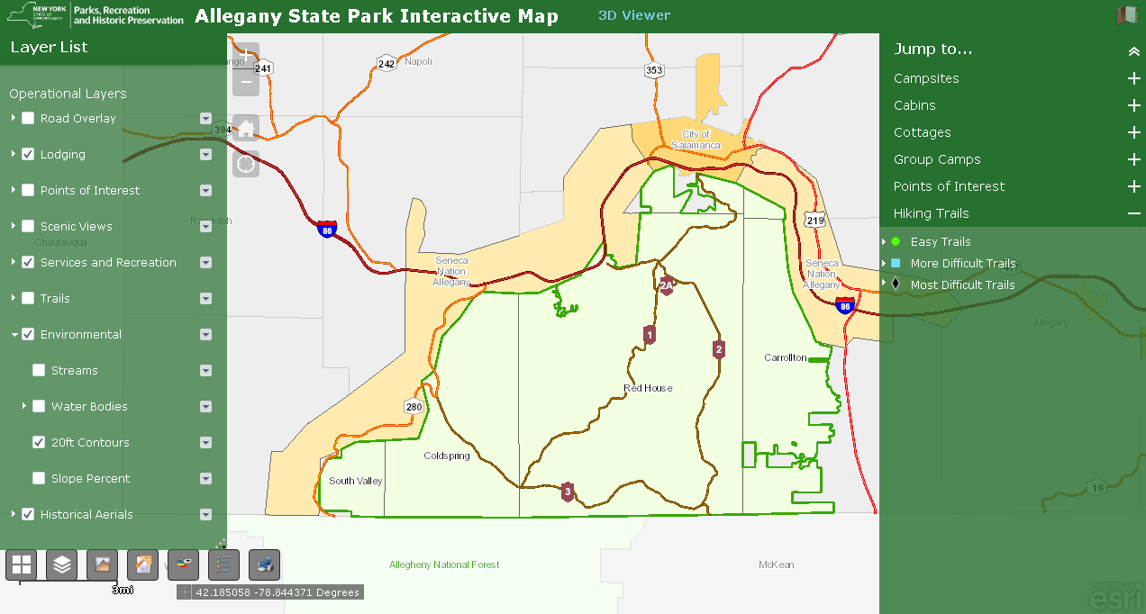
While GIS as a shared service as part of Governor Cuomo’s County-Wide Shared Services Initiative (CWSSI) has yet to take hold in a broad context across local governments in the  Empire State,  the statewide GIS community does have a great example to highlight how local governments can collaborate with a state agency in sharing geospatial technology.  Case in point:   The Allegany State Park Interactive Map viewer.

Located in Cattaraugus County in western New York abutting the Pennsylvania state line and  north of the Allegheny National Forest, Allegany State Park was created in 1921 and encompasses nearly 64,800 acres.   A major western New York State tourist attraction – the park averages  1.5 million annually – the park offers a wide range of four-reason recreation activities and lies within the Alleghany Highlands Forests ecoregion.   The idea of a joint effort between  Cattaraugus County and Allegany State Park online map viewer idea goes back as far as 2010 as part of a discussion between Daniel T.  Martonis, who at the time was GIS Manager for the County and Tom Livak who was then Director of Economic Development, Planning & Tourism.

The initial viewer was more emergency services focused with the collection of infrastructure data and intended for use by park staff only – nothing external.  Most of the data was collected by Dan and Tom, including Chris Holewinski – the current Cattaraugus GIS Manager – using various Trimble GPS units as well as utilizing old engineering maps.  The trio even brought out metal detectors to pick up the locations of pipes.   At the time, Dan was building web mapping applications with ArcIMS that Dan mentions was not “people friendly” and was ultimately discontinued by ESRI.  Along the way, though, both Dan and Tom knew they were beginning to frame a web mapping product which would be of great value to both the County and ASP.  ArcGIS Online began to emerge as a more functional and adaptable web mapping platform providing additional opportunities for the two government programs to build upon what had been started.

The ASP viewer represents the ongoing collaboration between Cattaraugus County and Allegany State Park. It provides easy to use access to a facility, environmental, and cultural data including historic aerial photography.

Continue reading

10 Questions: Christine Gayron, Gayron de Bruin Land Surveying and Engineering, PC

Christine Gayron currently serves as President of Gayron de Bruin Land Surveying and Engineering, PC (GdB) based in Melville, New York.   The company provides a wide range of geospatial products and services for clients in the Empire State.  As part of eSpatiallyNewYork’s continued effort to reach out to the statewide geospatial professions, we were able to meet and have a conversation at the 2019 New York State Association of Licensed Surveyors (NYSAPLS) annual conference.

eSpatiallyNewYork:  GdB was created in 2010.  The company has made a lot of progress in a relatively short period of time and adding a lot of new technologies along the way – GIS, drones, laser scanning, etc. – how is the company making it all happen?

Gayron:  I only hire people who are awesome. They are the ones who make it happen. I just bring in the work and create a company culture that makes the employees want to be the best at what we do. I have to credit my partner, Greg de Bruin, for constantly pushing the envelope, and insisting on investing in technology, and Jason Graf, my partner in charge of operations, for putting the technology in everyday use. Greg introduced GIS in the 90’s before I started my career. I actually think my contribution was my ability to run the business and bring work in, creating a revenue stream that would allow us to afford to make the investments. So I grew the company and oversaw things and generated profit, while the technology nerds in the company figured out how to customize software and put new technology into use.

eSpatiallyNewYork: Tell me a little bit about your education.   B.S. in Geology – how did you make the jump to surveying?

Gayron: I have a BA in Geology from CUNY Queens College and a minor in secondary education. I thought I was going to be an Earth Science teacher, but a month into student teaching, I realized teaching was not for me. I wasn’t sure what to do. My stepfather saw an ad in the paper for GIS Specialists at an engineering firm called A. James de Bruin & Sons, the predecessor firm to Gayron de Bruin.  It was in Bethpage, NY, the next town over from where I live. I had taken one class in GIS in college. The mapping aspect of geology interested me more than the rocks and minerals part, so I applied for an entry level position. I was hired to draft utilities and base maps for utility company conduit design drawings. Then I worked with one of the engineers on the conduit design. I designed hangers to support conduits underneath a couple of bridges over the Long Island Expressway (LIE).   I also designed horizontal directional drilling of conduit underneath the LIE. When the conduit design work dried up, I started doing more boundary surveying and control surveys for NYSDOT.  I used GIS to plan control networks.  At 23 years old, I was managing design survey projects. There was lots of opportunity at the small family owned firm and I was good at seeing what needed to get done. As I approached licensure in 2010, my boss, Greg de Bruin, and I decided to partner and form Gayron de Bruin.  It was time for Greg to start planning for retirement and I was the successor.

eSpatiallyNewYork:  Early on, traditional surveying and engineering companies were a bit slow embracing GIS technology/software but today this intersection is complete.  GdB is part of the ESRI Partner Network and has ArcGIS Online Specialty Did GdB have ESRI capacity from the beginning?

Gayron:  We’ve always been an ESRI shop. We saw how ESRI had discounted licenses for schools and government and we knew that was key. As we are geospatial data collectors and data managers we push GIS as a data management tool to our clients.  We try to provide this to all of our clients. GIS is just one of the tools in the toolbox. It used to be a hard sell to get clients to use GIS, but ArcGIS Online (AGOL) has made that a lot easier because we can set up the GIS tools, bring the data in, and show them how to view, analyze, and manipulate it.

eSpatiallyNewYork:  Are the new/younger generation of surveyors – and engineers – who are just getting into the work force have a broad enough understanding/experience with GIS software?

Gayron:  We hire a lot of people right out of college with GIS education. We find that they have a basic understanding of what it can do, but how we use it in surveying and engineering is usually new to them. Most of it is learned along the way. I think this is true of most industries – college gives a basic foundation and only scratches the surface. Getting into the workforce is where the detailed applications and user expertise is developed.

eSpatiallyNewYork:  Speaking of data, what has GdB’s experience been in obtaining government data?  I see that elevation certificates and tax parcel data are key business components in your space.    What’s been your experience in getting this digital data across New York State?

Gayron: Orthoimagery has been very attainable and useful. Parcel data is useful for elevation certificates as you suggested. Tax map line work is valuable for getting an idea of what the parcel layout may look like, but it can be deceiving. We try not to use it on our drawings because we are licensed land surveyors and if we put a line on the drawing, it’s got to be in the right place. We love to see government offices scanning their maps and storing them in a GIS and making them available, but this is still rare.

eSpatiallyNewYork:  Drone technology is becoming a geospatial game changer.  What’s the GdB read on this evolving technology?

Gayron: So drones are all the rave, but they are really just another cool option in the geospatial tool box – a glorified robot camera holder.   It’s really the software that connects drone flights to GPS and uses drone photography to create point clouds and 3D surface models that I find impressive. Like other tools such as LiDAR, it is the accurate and precise control that yields accurate 3D models. The software is key in reconciling the data with the ground control.

eSpatiallyNewYork:  This is impressive  – “GdB is ranked in POB Magazine as one of the top 100 Geospatial firms in the United States.”

POB magazine gathered data in 2015 and 2016 on revenue in the geospatial community. I’m attaching the articles so you can see how they used the data to rank firms. They stopped doing it after 2016, but I’m certain we would rank even higher on the list now!

eSpatiallyNewYork:  How does Honeoye Falls, New York fit into the GdB business plan? It’s a long way from your Long Island headquarters!

Honeoye Falls is just outside of Rochester. So we wanted to expand the company and it seemed we had the choice to expand geographically providing the same services or we could expand our range of services to include more civil engineering. We decided to stick with what we are good at and do it farther away. My partner, Jason Graf, LS, found New York State Department of Transportation (NYSDOT) data available online. It listed NYSDOT projects by location and contract budget. He manipulated the data in GIS and created a heat map to see where NYSDOT was spending the most money. The New York City area glowed the brightest, of course. The next “glowiest” cities were Buffalo, Rochester, and Syracuse. With Rochester in the middle of those three cities, it seemed like a place to look into. We had some contacts there and did our research. Within one year of starting to think about a Rochester office, we had the branch office open with 5 employees. 18 months later, we have 11 employees and they are all busy! Scott Smith, LS, the Branch Manager, is building an all-star team upstate. I truly believe that the bringing on the right people drives our success. As we grow, we are putting effort into making our operation more structured and efficient, but as stated above, we only hire people who are awesome, and I want them to feel appreciated for their ideas and contributions.

eSpatiallyNewYork:  What are some of GdB’s current larger or unique projects using geospatial technologies? 

Power companies are putting out very large corridor projects requiring surveying and mapping of several miles along a proposed power line route. I think these projects are coming about as new forms of energy generation are being developed. They need transmission lines to connect the new power plants, solar panel fields, and wind farms to traditional power grids. We also do large mapping projects for design of infrastructure in New York City. The city’s infrastructure is crumbling and needs upgrading. One of the first steps is mapping the existing conditions. These jobs are always a huge rush.

eSpatiallyNewYork: Considering all of GdB’s business – what is the breakdown between private and business clients? 

Most of our work is for government agencies. The breakdown is aboutt 80% government agency work, and 20% private clients.

eSpatiallyNewYork: Tell us about the online teaching you do through GeoLearn?

I met Joe Paiva, the founder of GeoLearn, before I got licensed because I took his review course when I prepped for the Licensed Land Surveyor test, and then I would see him at conferences a couple times per year. Joe is an excellent presenter. Joe knew that I was doing some presentations to professional organizations and he knew that my company was using GIS and other new technologies in Land Surveying – so he asked me to present courses on GIS for GeoLearn.  I prepared power point slides just like I would for a live presentation. I flew to GeoLearn’s studio in Kansas City to record them. It’s actually much easier to present this way, because you only have to present 10-15 minutes at a time to create the segments. Being in the studio was a very cool experience!

eSpatiallyNewYork:  Work aside, I understand you’re a triathlete and compete in many similar events.  What’s next on your calendar? 

Last year, I qualified for XTerra World Championship race in Maui. This is an off-road triathlon consisting of an ocean swim, mountain bike, and trail run. Unfortunately, I was injured a couple weeks before the race and didn’t go. This year, I am not signed up for any races, which is an interesting experiment, because I’m still training, but without the pressure of an upcoming race. So I know I’m doing it because I really love it. I usually wake up at 4:30am and train early in the morning. I’m done by 8am in time to get my kids off to school and get to work. I am married to a NY City Firefighter and we have three amazing children, who are very active. Right now, I’m ok with putting my racing career on hold to attend their lacrosse games, concerts, and cheer competitions.

Contact:

Christine Gayron, President
Gayron de Bruin Land Surveying and Engineering, PC
cgayron@gayrondebruin.com

NYSAPLS 60th Annual Conference January 28-30 Saratoga Springs

eSpatiallyNewYork had the opportunity to participate in the recent New York State Association of Professional Land Surveyors (NYSAPLS) annual conference in Saratoga Springs in late January.  In doing so, I was able to meet with numerous NYSAPLS members, including briefly with current NYSAPLS President Greg de Bruin, as well as several vendors in the exhibit hall.  Having run almost exclusively in the statewide GIS circle for the past 25+ years, and having really no reference point what to expect at the show – I was not disappointed.
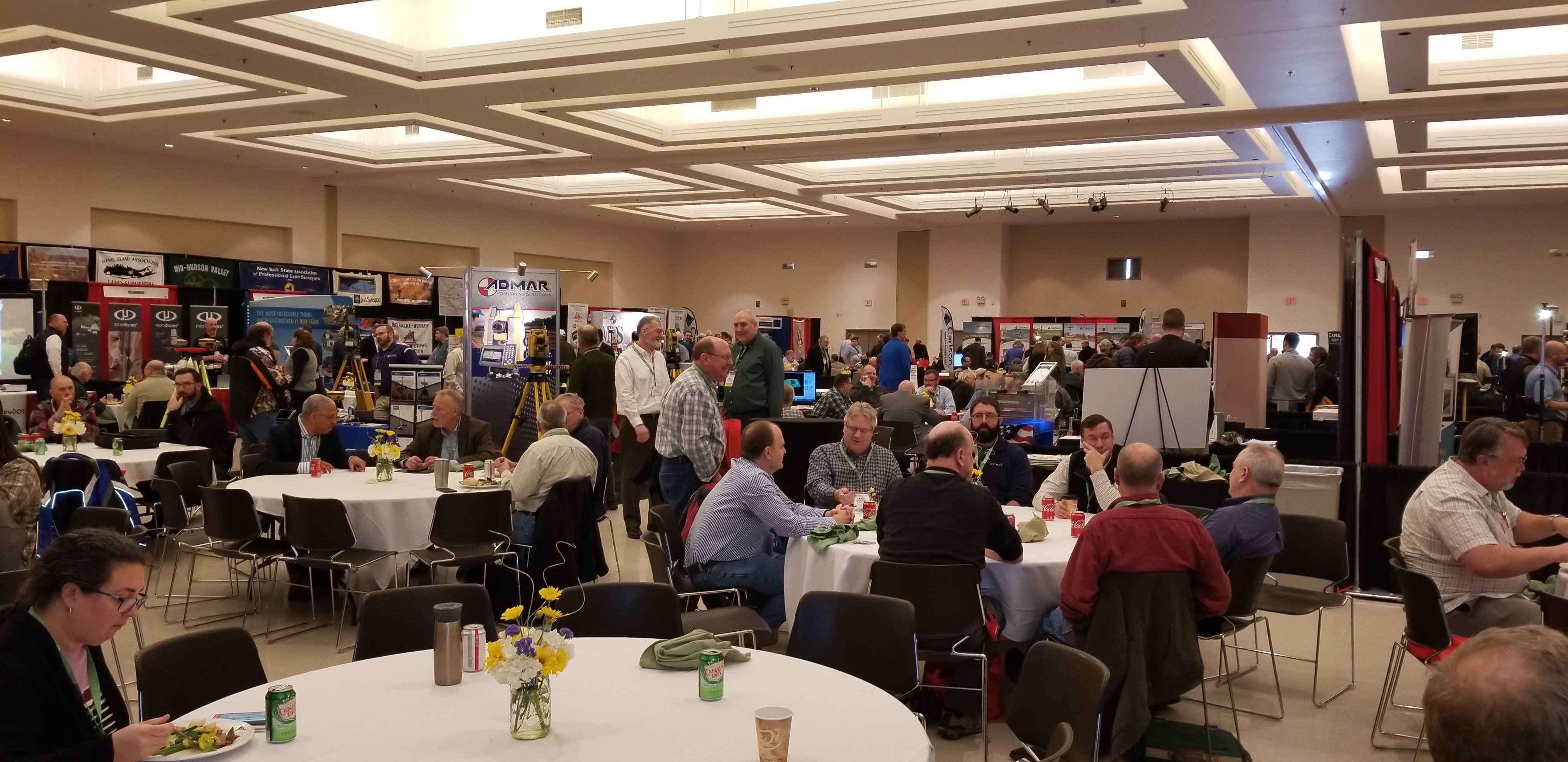
The three-day conference brought together 704 registered attendees with the overall total reaching 775 when including 31 exhibitor representatives.  While I was almost certain to see components of the traditional surveying profession (i.e.,  leveling rods, measuring tapes, tripods, safety equipment/clothing, nails and spikes, monuments,  flagging and marking paints – the customary surveying equipment fare), I was pleasantly surprised to see in both the exhibit hall and throughout individual presentations evidence of the statewide surveying community investing in a variety of developing technologies such as laser scanning, drones, 3D, advanced GPS and photogrammetry, and an abundant number of emerging mobile and field programs.   Quite noticeably, surveying firms offering a broader range of geospatial products and services.   It was clear on the exhibit hall alone how the Empire State surveying community is embracing state-of-the-art geospatial technologies in 2019.

The exhibit hall at this year’s NYSAPLS conference offered an impressive line-up of vendors. The daily Strolling Lunch with Exhibitors engages attendees with the exhibitors.

The conference offered a very diverse range of presentations, classes and workshops.  Of particular interest was to see presentations focusing on Building Information Modeling (BIM), 3D Building Rights and Air Rights, and several focusing on the drone/UAV.  Given the surveying profession’s important role in the development and maintenance of statewide tax maps, there were a number of sessions dedicated to the issues associated with land ownership including easements and right-of-ways, tying into and using historical documentation, tides and tidal datums, highway law, and even canal boundary retracement.  Though I was unable to attend, a class on stone walls focusing on their importance in land records and property boundary definition  was held.  Even a class on “Dendrology for Surveyors” class was included on the agenda. Of course there was a very visible presence of the field of photogrammetry which remains a staple throughout the profession, while new capabilities in the field of underground and subsurface mapping were also on display.  Making reference to the range of content at the conference, Ben Houston, Professional Engineer, Associate Member of NYSAPLS and NYS GIS Association Board Member commented  “This year’s NYSAPLS Conference offered a nice mix of training and social/networking opportunities. I was particularly impressed at the number and variety of professional services and geospatial data vendors in the exhibit hall.”

Of course there was ample time for mixers and social events at this year’s NYSAPLS conference. One of the Special Events at the show was the Field Olympics. Participants were able to compete against others in three events one of which was Tree Identification. Is that Ginkgo Biloba in #4? And here are the winners of this year’s map contest!

An important takeaway for me from the NYSAPLS conference was the focus on the business of surveying.  A geospatial profession largely dominated by private practice, business and industry, and enabling itself to create a presence in Albany.  As part of this presence, NYAPLS has recently created a Political Action Committee (PAC).  PACs are a type of political committee, once properly registered, which can engage in promoting candidates for election to public office that share the views, interests, and concerns of the land surveying community. This new committee is one of several active NYSAPLS groups working on issues such as standards and strategic planning.  Outreach and communication to the professional engineering communities and the State Board for engineering, land surveying, and geology remain priorities as well. (New York State professional surveyor accreditation and licensing is administered through the NYS Education Department Office of the Professions.)  “This year’s conference was outstanding”, notes current NYSAPLS President Greg de Bruin, “the facility, content, conference coordination were all first rate.”

For those involved in mapping technologies within the Empire State, it’s worth the time to visit the NYSAPLS website to see the many areas and programs this professional organization touches across the geospatial community.  There are a multitude of opportunities for collaboration.

Contact:

Amber Carpenter
amber@nysapls.org
518-432-4046

Greg de Bruin
gdebruin@gayrondebruin.com
516-805-4118

Wayfinding: Geospatial Goes Indoors with Connexient

As GIS and mapping technologies evolved through the later part of the 20th century focusing mainly on the physical(outdoor)  landscape, the digital mapping of the  built/interior environment continued to focus on the use of AutoCAD/Revit and related CAD technologies.  With exceptions, there were two definitive geographic mapping camps:  Geographic Information Systems (GIS) software vs. Computer Aided Design (CAD) software.   One or the other.  And with little integration of both.

As both technologies matured, integration between the two computing environments became more common and the lines of division blurred.  New technologies including, but not limited to Global Positioning Systems (GPS), Laser Scanning, Building Information Modeling (BIM), and drones, as well as advancements in 3D modeling and increased desktop and internet capacity aided to the continued integration of the software platforms. GIS and BIM Integration Will Transform Infrastructure Design and Construction is a very recent and quick read from Autodesk charting the path of this flourishing market.

Fast forward to 2018 and the evolution of indoor wayfinding which leverages many of the components of these same outdoor and indoor mapping concepts.   Based on a similar spatial data model, Wayfinding applications are now found in a wide range of public spaces, educational and industrial campuses, entertainment and athletic venues, buildings, and healthcare facilities.  Offering indoor maps for handheld mobile devices is becoming more and more common, as are digital information kiosk systems in office complex lobbies, and as part of web mapping applications. (It is often recognized that The Americans with Disabilities Act of 1990 (ADA) represented a milestone and was instrumental in helping to make spaces universally accessible and improving wayfinding for all individuals.)

Connexient

New York City-based Connexient was formed in June 2012 with the vision that indoor GPS and navigation will become as widespread inside as it is outside.

With over 60 licensed hospital client sites and a total square footage over 70 million square feet mapped, Connexient is a market leader in healthcare in providing  smart phone based turn-by-turn indoor navigation and all screens digital wayfinding solutions.   Leveraging significant breakthroughs in the ability to implement low cost, navigation quality indoor positioning, users can now expect the same kind of functionality –  intuitive, reliable and accurate maps, directions and turn-by-turn navigation which is commonly available from outdoor world mapping and navigational companies such as Google, Apple and Waze.    The same user experience can be available via a mobile app for any large, complex indoor facility or campus that they enter.  Today, these capabilities are highlighted in Connexient’s flagship product MediNavTM.

Selected MediNav functions include:

  • Multiple levels of zoom and detail
  • 5D visualization and 360 degrees of freedom of camera control
  • Detailed routing network and intelligent routing
  • Turn-by-turn instructions
  • Visual landmarks (signage) to provide locational reference
  • Visual and audio turn prompts
  • Off-route notification & route recalculation
  • “Balcony view” route visualization – what is coming next
  • 1 to 2 meter accuracy
  • Dynamic refresh of user position
  • Parking Planner, Find my Car and Meet Me
    Continue reading

10 Questions: Michael R. Martin, CLM

GIS applications in water quality analysis and mapping historically have not been one of the more visible uses of geospatial technology across the Empire State.  While revisiting some of my contacts in the Adirondack Region, I connected with Michael Martin, CLM (Certified Lake Manager) at Cedar Eden Environmental. Michael has a long history of professional work based in the North County which intersects mapping and geospatial data collection with water quality analysis, watershed management, and land use planning. He is actively involved in several professional organizations and continues to work across the region.

eSpatiallyNewYork: How did Cedar Eden Environmental get started? 

Martin:  I started Cedar Eden Environmental after 16 years in the environmental field working in the public, private and non-profit sectors. I was born and raised in New Hampshire and had an interest in the environment, lakes and ponds in particular, from a very early age. I attended the University of New Hampshire when, at the time, there was no such thing as a degree in Limnology (the study of freshwater systems), so UNH co-taught limnology through the Botany and Zoology departments. While at UNH, I specialized in phytoplankton and limnology. After graduating with a BS in Botany, I was hired by the State of New York’s Department of Environmental Services in the limnology department, where I sampled numerous lakes around the state and became the State’s expert on phytoplankton. From there, I went to work for an environmental consultant in Pennsylvania. In 1992, I moved to the Adirondacks to establish the Adirondack Aquatic Institute, a non-profit research institute focused on human impacts to water quality. Over the past 30 years I have worked throughout New England, the Northeast, the Adirondacks, Mid-West and West Coast diagnosing water quality issues, conducting environmental monitoring and developing holistic, long-term water quality and aquatic plant management plans for individuals, municipalities, water suppliers, lake associations, environmental organizations, NGOs and government agencies.  In addition to my business, I established a non-profit educational outreach, LakeStewardship.org, in 2006 to promote lake and environmental stewardship in North America and to serve as a resource for lake residents, lake associations, lake managers and cottage owners associations.

eSpatiallyNewYork: So lake, watershed and environmental management services are the focus of your work?

Martin: The main focus of my work is on environmental management, especially lake water quality, watershed management and aquatic plant management. What happens on the land within a watershed determines the water quality of downstream water bodies. I use a combination of data collection, data analysis and geographic data processing in the development of management plans. I also use GIS-based models and GIS-derived data to predict the impact of land use and changing land use on water quality. In addition to lake and watershed management planning, I have been involved in a number of projects that evaluate large datasets consisting of 10 to 20 years of data, where I use GIS and statistical software to analyze both temporal and geographic trends in water quality.

 eSpatiallyNewYork:  Tell us a little about your geospatial background and how you introduced it into Cedar Eden’s client service.  

In 1980, my college advisor had an interest in acid rain impacts and got me started on creating isopleth curves for pH and alkalinity in NH lakes. This was very early GIS so I had to digitize everything on a large table-sized digitizing board, including the outline of the State of New Hampshire and the locations of each of the lakes in the state. I developed algorithms to convert point data into isopleth curves across the state. This fascinating work got me interested early on in the power of geographic tools for environmental assessment. While working for NH  Department of Environmental Services I sampled lakes and built computer models to evaluate the impact of development on lakes.  As a result, I was asked to serve on NH’s GIS Steering Committee.  Examples of CEE’s GIS work can be found on my website.

Having grown up along with GIS, I am thrilled by the availability of data nowadays. Gone are the days when users would have to digitize everything by hand such as soil polygons from county soil books and wait overnight while our computers geo-rectified and created topology for the digitized layers (and hope the application didn’t crash during the night). I have been using ESRI products since the beginning, starting with ArcCAD and some early desktop mapping products. I was one of only 100 worldwide recipients of the Geodyssey Environmental GIS research Grants sponsored by ESRI & AuotDesk for using desktop GIS technology in environmental applications. As recipients, we were brought to Redlands, CA for training at ESRI headquarters.  Currently, I am using ArcGIS 9.x and use readily-available base data as the starting point for my projects. I have not upgraded to ArcGIS 10 although I have used ArcGIS 10 while working on subcontracts. I use standard GPS (Garmin Oregon 650t) and GPS-enabled depth finders (Eagle/Lowrance Model 480 Recording Sonar\GPS+WAAS Mapping Unit) for data collection since I generally do not need sub-foot accuracy for my projects. I have been involved in several projects requiring more accuracy and have subcontracted for digital surveying and digital topography from aerial photography. In my space, the use of drones has the potential to assist in efforts  like aquatic plant mapping.

eSpatiallyNewYork:  How does water-based (surface, submerged, etc) geospatial data collection differ from land based data collection?

Martin: Geospatial data collection for water-based applications is similar to land-based applications, though it tends to be more time-consuming. On land, you are able to stand still while acquiring data but this is not possible while floating on a lake.  This is an area where I believe there will be growth in the use of drones  – mapping features (like aquatic plants) in open water.  Generally, however, because we do not need sub-foot accuracy, we are able to acquire data while moving. For instance, to create a bathymetric map, we use a GPS-enabled fathometer that continuously records water depth and location. The same system can be used to map the edges of a littoral zone (area of plant growth) of a lake by driving a boat towards and away from land and triggering a waypoint each time the edge of the littoral zone is passed over.

 eSpatiallyNewYork:  Cedar Eden has been involved in some focused non-watershed/water quality mapping projects such as agricultural inventories – what can you tell us about these projects?

Martin: CEE has been involved in a number of non-watershed mapping projects. In Fulton County, we provided mapping for use in the development of an updated county-wide agricultural management plan. In Lewis and Columbia Counties in the early 2000s, I created master GIS libraries and provided on-site GIS training for their County Soil & Water Conservation Districts (SWCD). Columbia County SWCD was particularly interested in the Hudson River Valley, so I also created a detailed topographic and resource-based map of the Hudson River Valley. The Town of Santa Clara is close to my office in Saranac Lake and is adjacent to one of the largest Adirondack lakes which I have studied for years. In the mid-1990s I was asked by the Town to prepare a new zoning map for them. I saw this as a perfect opportunity to utilize GIS for its data management and mapping capabilities. I worked with the Town Supervisor to transform the Adirondack Park Agency land use map into town-based zoning.

eSpatiallyNewYork:  Cedar Eden was part of a Statewide Agricultural Environmental Management (AEM) GIS project.  What was the size/scope of this project?

Martin:  The Statewide AEM program is a tool used by the County SWCDs to monitor and assist agricultural activities within their respective counties with the goal of minimizing environmental impact. I was hired by NYS Department of Agriculture and Markets and the NYS Soil & Water Conservation Committee early on to develop a GIS-based data entry and management system so that each county could track AEM participation using GIS and so that the State could evaluate statewide trends in AEM. I built customized GIS base layer datasets for each county, created a data entry system using Visual Basic and then traveled around the State teaching the counties how to use the new program. I also collated all of the initial data into a statewide GIS and provided the initial statewide analysis of the results from the program. The AEM program is still in use today, tracking agricultural entity’s participation in various incentives designed to minimize the environmental impact of agricultural activities.

eSpatiallyNewYork:  You’re involved in professional organizations such as the North American Lake Management Society, New York Federation of Lake Associations, Certified Lake Managers, what is the role of geospatial technologies in these circles/organizations?  Is geospatial a “must-have” skill set to work in water quality/watershed management disciplines?

Martin:  Involvement in relevant organizations is important to both gain and share knowledge. I was past-president of the North American Lake Management Society (NALMS), past Regional Directors for NALMS and the New York Federation of Lake Associations and was a founding member of the Indiana Lake Management Society. I am a Certified Lake Manager through NALMS. Early on, geospatial technologies were experimental and research-based. Over time, as the technologies matured, and the usefulness of their application became apparent, geospatial technologies began to move into the fields of limnology and watershed management; and therefore knowledge of these technologies became known.   GIS/geospatial are must-have skills for anyone wishing to start out in the environmental fields as geospatial information & analysis are important and pervasive tools in environmental management. There is virtually no application of applied limnology or applied environmental management where geospatial information is not processed. Citizen scientists are now being taught the use of geodata collection and geospatial mapping in order to conduct their own mapping of aquatic plants and map the locations of invasive species.

 eSpatiallyNewYork:  Invasive species is a major concern across the Empire State today. How is this playing out in your work?

Martin:  I have been involved with invasive species since I graduated in 1984. Invasive species issues have always been a concern in the northeastern United States, but where we once were projecting what might happen we are now dealing with the realities of those projections.  Invasive species are a present threat to much of what we value as natural systems, both aquatic and terrestrial. CEE work focuses primarily on the aquatic side and I am asked to deal with aquatic plant management planning more and more. It is hard to get folks to focus on much else when they see their lake being covered by Eurasian milfoil or some other aquatic non-native species. Invasive species alter the entire ecosystem, including nutrient cycles, within a lake and managing invasive species becomes an integral part of overall lake management.  I work  with a number of lake communities  now who are attempting to restore a balanced aquatic plant community because they relied on the advice of  lake management companies which over-treated the lake and had all of their native plants wiped out along with the non-native (invasive) species.

 eSpatiallyNewYork:  Do you attend any of the statewide GIS conferences?

Martin:  I do not regularly attend GIS conferences. I have attended these in the past but found that the focus was not generally in my area of interest. However, I do have information to share on the use of GIS in environmental management and will look into future conferences.  However, when I attend regional, state and international environmental conferences, I follow and often contribute to the GIS & geospatial tracks. These conferences include the North America Lake Managements Society’s (NALMS) International Symposium, the New York State Federation of Lake Associations’ annual conference, the New England Chapter of NALMS and others.

eSpatiallyNewYork:  What’s your association with the Adirondack Watershed Institute?  What other organizations do you work and collaborate with in the Adirondacks?

Martin:  In 1991, I was the founding Executive Director of the Adirondack Aquatic Institute at Paul Smith’s College. When I left in 2000, the institute was renamed the Adirondack Watershed Institute (AWI).  Today, I am only tangentially involved with their operations and occasionally   utilize their water quality laboratory for projects. I continue to stay active with the Adirondack Lakes Alliance as well as the NYS Federation of Lake Associations and the various NYS Partnerships for Regional Invasive Species Management (PRISM).

 eSpatiallyNewYork: Who are you working with now?

Martin: I have a number of municipal and association clients. On the lake management side, one of my longest running clients is the Mount Arab Preserve Association. I have been monitoring their two lakes since 1992 when I was at the Adirondack Aquatic Institute. They have stuck with me through all my career moves and we will be starting up our 27th year of monitoring this June. On the geospatial side, I am once again working with the Town of Santa Clara. The Planning Board has asked me to update the Town’s zoning map. When the map was initially created using the APA land class map, there was no parcel information and the scale of the source maps were to great for any accuracy. The Town had an issue when a property was being sold and it wasn’t clear from the existing maps what the zoning was (the parcel appeared to be split into two zones). As a result, I am in the process of using parcel maps to ensure that zoning is accurate at the parcel level. This is an iterative process, involving GIS mapping and then consultations with the Planning Board to resolve issues where the intended zoning isn’t clear at parcel-level scale. I also have a number of lake and plant management planning clients, primarily located in eastern NYS.

eSpatiallyNewYork: What’s the next big thing in New York State water quality?  

Martin:  In addition to invasive species, climate change is having a noticeable detrimental impact on the water quality of NYS’s lakes and ponds. Lakes are becoming warmer in the summer and the ice-free season is becoming longer. As a result, I see more and more lakes experiencing blooms of cyanobacteria (bluegreen algae) which are potentially toxic. Managing nutrient levels that control the growth of algae and managing aquatic plants (native and non-native) become more critical as the waters warm and the growing season lengthens. This can only be done through a combination of in-lake and land-based solutions to nutrient pollution control. It is critical that lake associations and municipalities begin to manage water quality in the long-term using a planning-based approach rather than in the short-term, using chemicals to treat symptoms. The latter approach may provide short-term relief, but it further destabilizes the ecosystem, causing chemical-dependency and additional water quality problems.

For more information, contact Michael Martin @ mmartin@cedareden.com.


10 Questions: Jonathan Cobb


I’ve had the pleasure of knowing Jonathan Cobb for nearly two decades.  As part-owner of Waypoint Technology Group based in Albany, Jonathan and his company product line and services are well recognized to the New York State geospatial community.  Waypoint is also a long-time supporter of many statewide geospatial events and programs.  I had the chance to catch up with Jonathan at 2017 GeoCon in Lake Placid to discuss some of Waypoint’s current business efforts and new trends in GPS-related technology.

eSpatiallyNewYork: How did you get started with Global Positioning Systems (GPS) technology and the story behind Waypoint Technology Group?

Cobb: As with so many career trajectories, mine was circuitous and unplanned.  After growing up in western New York and graduating from the University of Rochester with a dual degree in Mechanical Engineering and Geology, I relocated to the Albany area to begin my professional career as a junior engineer/geologist.  It was in this capacity where I was first introduced to GIS technology.  It was 1990 and I was assigned to work on two projects that involved the siting of new sanitary landfills.  GIS was the underlying technology that was used to determine the relative favorability of candidate sites.  While not a GIS practitioner, I worked closely with my firm’s in-house GIS technicians to develop the relevant graphical overlays and to compute various quantitative values that were used to support the siting process. Simultaneously, I was consuming all of the written material I could find that related to the growing application of GIS technology, and became intrigued with what was at the time the poorly understood commercial potential of the global positioning system (“GPS”).  Shortly thereafter, and with the help of my business partner Greg Hunt, Waypoint Technology Group  (“Waypoint”) was born.

eSpatiallyNewYork: You’ve been a Trimble distributor for many years.  These relationships are still strong moving forward?

Cobb: Within one-year of forming Waypoint we were approached by Trimble to represent their interests in the northeastern United States – but most especially New York – as a distributor of their mapping, GIS, and land surveying solutions.  That was nineteen years ago and yes, we’re still going strong.  Our current portfolio of Trimble solutions now includes robotic total stations for land surveying and 3D scanners, which have become very accessible – from both an economic and functionality perspective – in recent years.  In addition to Trimble, we also represent Laser Technology, Inc. (“LTI”) is a leading manufacturer of professional measurement solutions, based primarily on laser technology.  LTI’s products fulfill an important niche for our customers, both in stand-alone form as well as in conjunction with Trimble solutions.

eSpatiallyNewYork: Smartphone technology has significantly changed field data collection.  How has this changed your business model?  Who is using what?

Cobb:  We refer to the deployment of smart phones (as well as tablets) for the purpose of geospatial field data collection as a manifestation of the Bring-Your-Own-Device (“BYOD”) revolution.  This development is something of a double-edged sword in that the ease of smartphone-driven app-based data collection effectively brings that power to anyone with a device and a data plan (i.e. virtually the entire population); at the same time, questionable claims of positional accuracy coupled with the absence (often) of authoritative  metadata persist.  This has resulted in manufacturers such as Trimble developing compact, lightweight, high-performance GPS receivers for the express purpose of pairing wirelessly with smartphones in order to bring professional-grade positional accuracy to the masses.  With respect to the impacts on our business model, I’d say the key differences are two-fold.  One – professional grade solutions are no longer the sole province of larger organizations or those with substantial technology budgets and/or in-house IT resources; and two, the use of smart phones and apps has spawned an entirely new breed of services (e.g. data collection apps, differential correction data streams) that are built upon pay-as-you-go or subscription-based revenue models.  

eSpatiallyNewYork:  What’s the composition of your client base in 2017?  (i.e., Surveying/engineering, general data collection, academic, recreational)?

Cobb:  Waypoint is fortunate to have cultivated a diverse customer base over our nearly two-decade existence.  While the distribution varies on an annual basis, our active customers are comprised of an approximately even split between the private and public sectors.  Within the private sector, consultants (e.g. engineers, land surveyors, ecologists) make up the largest segment, while in the public sector, local and state government agencies dominate, followed by the federal government.  Academic institutions make up less than 10% of our customer base in any given year, but are significant in that the instructional and research arms expose students – future potential clients – to our portfolio of solutions.

eSpatiallyNewYork:  What percentage of our business are repeat customers?  How might current market place factors be affecting your client base?

Cobb:  We add new customers on a weekly basis, but the vast majority of our customers are of the long-term/repeat variety.  This is partly due to the nature of the technological solutions that we sell; that is, once a customer has made an initial investment in hardware and software — and very often, training – switching to a different platform can be cost-prohibitive.  In addition, many customers elect to protect their investment through annual hardware warranties, software maintenance, and technical support service contracts.

Going forward, the migration toward “bring your own device” solutions and software-as-a-service solutions promises to tilt our business model into one that is more heavily reliant upon recurring revenue.  For example, in addition to subscription-based software applications which are now ubiquitous, we are seeing a transition to short-term pay-as-you-go, differential correction data streams to improve the positional accuracy of the location services technology that is onboard consumer devices, such as cell phones and tablets.  This innovation opens the door to high-accuracy position determination for a potentially large segment of end-users that would have otherwise been unreachable due purely to cost.        

eSpatiallyNewYork:  Waypoint has worked internationally.  Tell us or highlight some of these clients and their projects.

Cobb:  In addition to supplying the United Nations with solutions that have been deployed in challenging political regions, including Lebanon, Eritrea, and Senegal, we have provided on the ground training and consulting services at the American University of Kosovo (“AUK”), in the young nation’s capital of Pristina.  AUK is affiliated with Rochester Institute of Technology (“RIT”), and it was through our long history as an RIT vendor that we were invited to participate on that project, which also included training services for engineers in Kosovo’s nascent national electric power transmission authority.  We have also supported RIT’s other international efforts through the donation of hardware and software to support humanitarian missions in Haiti and Rwanda.

eSpatiallyNewYork:  What’s the coolest or most unusual client application you’ve worked on using GPS technology in New York State?

Cobb: Great question.   With such a diverse clientele this is a difficult one to answer, but if pressed, I think I’d have to settle on one of the many unique applications of 3D scanning technology that has been led by a member of Waypoint’s staff.  The project focused on the precise recording of the existing conditions of the roof of the New York State Capitol in Albany.  This was in support of an architectural restoration project and is an excellent example of the utility of 3D scanning.  Another one was performing a similar function in an abandoned elevator shaft.  But for me, the most interesting application was deploying the scanner to capture a three-dimensional representation of a remote and difficult to access bat cave in support of research related to the devastating and widely-publicized white-nose syndrome.

eSpatiallyNewYork: What do you see as the next big “GPS” technology advancement?

Cobb:  Hmmmmm…….the “next” big advancement has arguably been commercially viable for several years.  That is, the transition from GPS-only solutions to GNSS-based solutions.  Specifically, this refers to GPS as strictly the American satellite constellation, whereas GNSS (global navigation satellite system) is intended to incorporate ALL constellations, including American, Russian, European, and Chinese.  The growth of GNSS-based solutions, which translates to the ability to acquire and continuously track many more satellites, has allowed for accurate positioning in previously challenging conditions (e.g. urban canyons, dense forests).  The transition from GPS to GNSS has been so profound, that even the lexicon has evolved:  we now routinely use “GNSS” in place of “GPS”. Beyond that, component miniaturization, extended battery life, and of course, the rapid proliferation of drone technology will continue to significantly impact the geospatial data capture landscape for years to come and GPS/GNSS will continue to be an important part of that evolution.

eSpatiallyNewYork:  If you had your way, what’s the one GPS “investment” you’d like the NYS geospatial government and business community to make?

Cobb:  Education and training.   Acquiring hardware and software is simple; trivial even.  I’d like to see a greater proportion of technology resources devoted to understanding the capabilities – and importantly, the limitations — of geospatial technology, rather than that aspect being treated as an afterthought.  The vast majority of questions that we field from end-users relate either to software operations or positional accuracy concerns.  For many organizations, a modest investment in comprehensive training would not only result in measurably superior positional accuracy, but it would also improve productivity.    

eSpatiallyNewYork:  Career Reboot:  What would you be doing if it wasn’t Waypoint?  Mason? Hockey player?  Teacher?  Sous Chef?

Cobb:  If I wasn’t working full-time at Waypoint, I would probably occupy time melding my dual interests in geospatial technology and world travel.  I’ve had the good fortune in recent years to blend these passions for both business and recreational purposes, and I have every intention of continuing.  Ironically though, I’ve found that the most memorable experiences occur when you leave the technology behind, ignore the map and the Yelp reviews, and just let the road lead you.