
Location: Littleton, New Hampshire
Website: www.cai-tech.com
Employees: 25
Established: 1985
Background

CAI Technologies has been providing GIS services to local and regional governments since 1989, making it one of the oldest and most experienced companies in the marketplace. Since it was founded in 1985 as Cartographic Associates, Inc, CAI Technologies has been a recognized leader in local government parcel data development. Instrumental in developing the original parcel fabric, including record research and compilation for more than 270 municipalities, CAI continues to support parcel mapping development and annual maintenance needs for over 650 local governments.
Other strategic CAI corporate business functions focus on geospatial technologies including enterprise geodatabase design, GPS field data collection/mapping, and implementation services for critical utility infrastructure. Focusing on water, sewer, and drainage infrastructure, CAI Technologies develops user tools which make system mapping, implementation, and ongoing maintenance cost-effective. Additionally, the company provides a full scope of development services including requirements analysis, functional design, development, installation, training, and support.
CAI has a significant New York State customer base as the company currently supports the business needs of clients through implementing industry leading geospatial solutions.
Illustrative Projects
East Hampton, NY ArcGIS Enterprise Support
Since 2015 CAI has supported the Town of East Hampton by providing staff and expertise for managing and upgrading their ArcGIS Enterprise. With each upgrade, CAI provides the Town with a detailed plan including scope and pricing to support each task. Plans are designed to include processes to minimize downtime, identify fall back procedures, and provide time for end user acceptance testing.
Upgrades initially focused on ArcGIS Server and migration of existing SQL back office and SDE database onto one hardware appliance. Next, CAI implemented Portal for ArcGIS to support Active Directory based logins with a federated ArcGIS Server. Once Portal was configured including the web adaptor, roles and permissions, CAI configured Web App Builder in the new Portal environment and migrated existing web applications. “CAI has worked on a number of projects for us over the years and we continue to go back to them because of their excellent service,” notes Bob Masin, GIS Manager, Town of East Hampton, “they work collaboratively with us to fit our needs, are responsive, and always go the extra mile to make sure the job is done right and to our satisfaction”
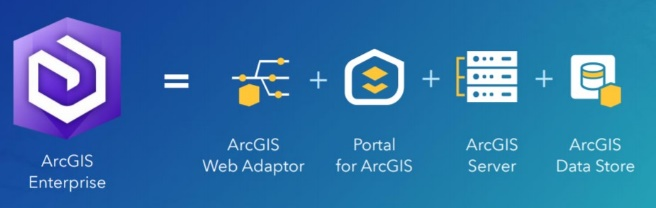
As new versions of existing software and add-on features become available, CAI coordinates implementation with the Town to ensure they are maximizing their return on investment. Most recently, CAI federated ArcGIS Server and Portal as part of an upgrade to Enterprise 10.9.1
Bedford, New York
The Town of Bedford for many years maintained tax parcel data in various formats. A Town wide parcel layer existed in shapefile format with a majority of the tax maps generated from AutoCAD. Some of the most current maps however only existed in PDF format. As a result, not all data sets were updated consistently each year which resulted in an inaccurate parcel dataset.
To meet the needs of the Assessor’s Office it was clear that the tax maps required updating and the resulting parcel data needed to be linked to the RPS assessment database. Using the existing source files, CAI digitized all of the existing lines and annotations into an ESRI geodatabase. Going as far back as 2011, deeds and plans were reviewed and parcels were recompiled in order to update the maps. Using additional information provided by the Assessor’s Office, CAI created GIS layers for condos and easements. Once updates were completed, CAI configured a Data Driven Pages map document file in order to print new tax maps from the GIS data.
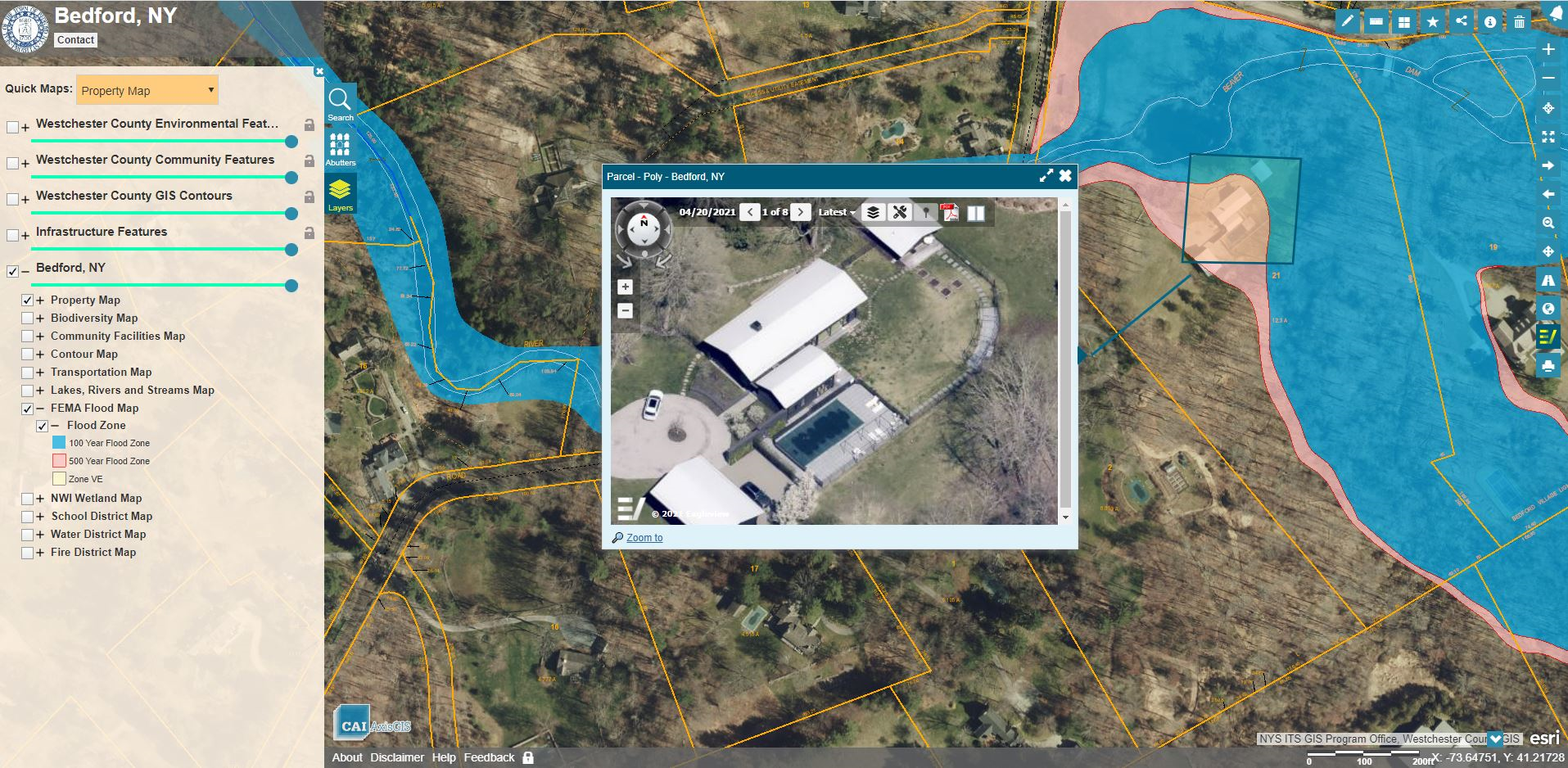
CAI assisted the Town of Bedford in converting both existing digital datasets and hardcopy maps, including condos and easements, into a ESRI Geodatabase. This will support future tax map maintenance functions and serve as the foundation of the town’s AxisGIS public facing application. https://www.axisgis.com/BedfordNY
Capitol Region Council of Governments, CT
CAI Technologies Receive Special Achievement in GIS Award
The Capitol Region Council of Governments, CT (CRCOG) and CAI Technologies were selected to receive a Special Achievement in GIS (SAG) Award from ESRI. This award is given to users around the world to recognize outstanding work with GIS technology. The CRCOG/CAI Regional Parcel Viewer and Regional GIS Portal web application stood out from more than 100,000 other applicants.
CROG is the voluntary Council of Governments organization supporting 38 municipalities in the Metropolitan Hartford CT area including the City of Hartford. It is the largest of the nine regional planning organizations in Connecticut. CRCOG provides services to member towns to promote efficient transportation, public safety, responsible land use, preservation of natural resources and economic development as well as supporting shared service initiatives between member communities.
The project is a self-hosted and self-maintained Regional GIS Portal and Parcel Viewer to serve CRCOG member municipalities as well as to provide a flexible infrastructure for internal and external users. Features include automating the collection and linking of parcel and computer-aided mass appraisal (CAMA) data for each community hosted as a 38 community fabric of parcels, providing productivity tools including generation of abutter lists and labels, and providing contextual data from local, State and Federal partners such as infrastructure, environmental conditions, natural resources, census information, and political geographies. Project tasks also included streamlining and automating the update of CAMA data to the site. CRCOG GIS staff are now able to add town-specific data layers without incurring additional costs.
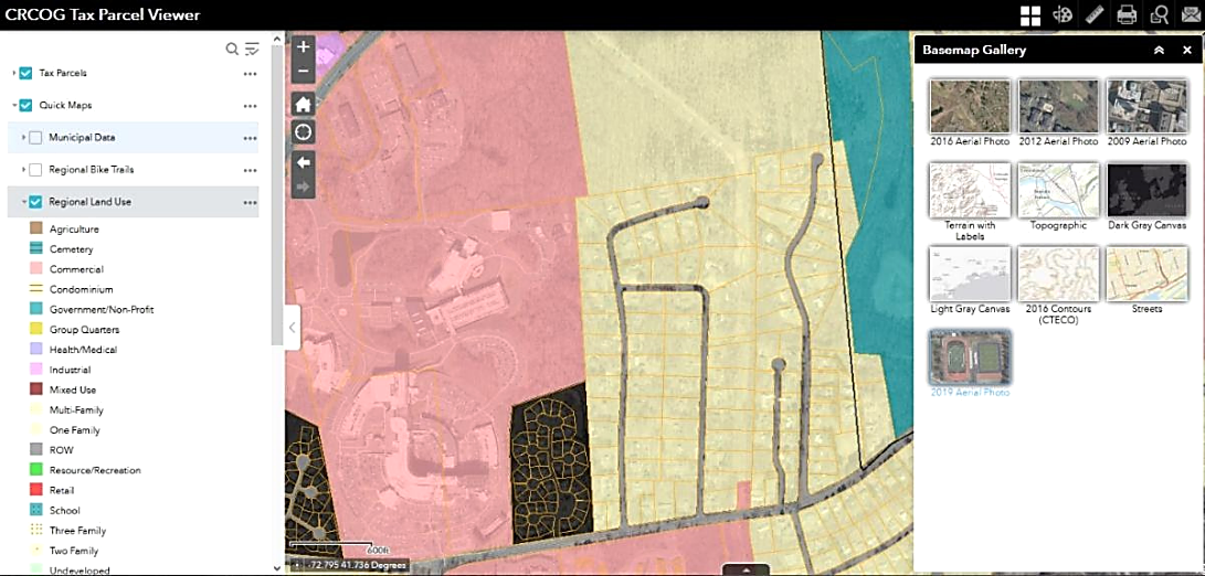
The CRCOG parcel viewer exemplifies the cost-efficiencies of shared services providing parcel data viewing and related mapping functions to 38 municipalities in the metro-Hartford area
The portal provides the region with an invaluable repository of property information to support local and regional planning and development while also allowing CRCOG to implement an ArcGIS Platform which will be expanded to serve other needs of the COG organization and member communities. The portal continues to be a collaborative effort between CRCOG and ESRI Business Partner CAI Technologies and can serve as a model for other regional planning agencies to follow.
The portal site can be visited at https://crcog.org/regional-gis/
Utility Mapping and Inspection Tracking Using GIS
CAI provides mapping services for their clients Water, Sewer and Stormwater systems. Working with client staff, CAI performs Global Positioning Systems (GPS) data collection of the system point features and at the same time provides connectivity of the utility pipe network.
Working recently for the Windham Water Works and Windham Water Pollution Control Authority in Windham, CT, CAI performed sub foot data collection and mapping for over 130 miles of Water system and 47 miles of Sewer system. Taking advantage of the already in place AxisGIS service CAI hosts for the Town of Windham, the utility systems are made available to each utility in a secure staff only accessible AxisGIS Editor service. Each utility now maintains their data using AxisGIS Editor and Field Maps for ArcGIS.
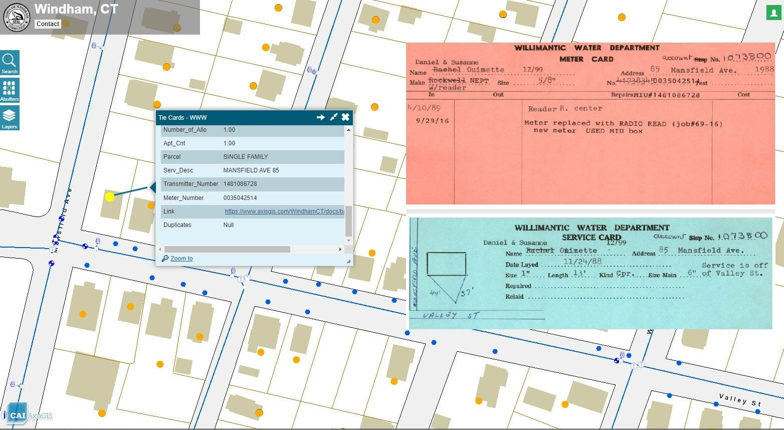
CAI also integrated the water utility’s customer database with the GIS, thereby allowing easy field access to the water service connection tie cards. Recently CAI configured ESRI’s Lead Service Line Inventory solution to support inspections required to meet the Environmental Protections Agency’s (EPA) Lead and Copper Rule Revisions.
With many aging sewer systems present in the Northeast, CAI works with clients to record and display their Manhole and Pipe inspections using GIS. Typical pipe inspections include capturing CCTV video. The camera operator records information relative to pipe condition, material, diameter and lateral locations. CAI is able to glean this information from the inspection software database in an automated fashion to update feature attributes, create GIS features representing sewer lateral connections and symbolize lines based on their condition. The CCTV video is linked to the corresponding pipe segment for easy retrieval in the field or office using AxisGIS or ArcGIS Online (AGOL).
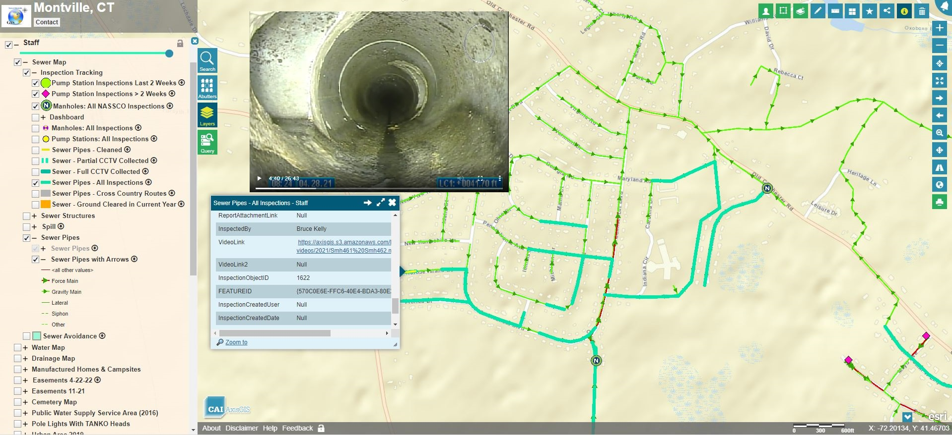
The AxisGIS platform provides an excellent framework to integrate and mash together several different types of infrastructure data types including geometry, reports, and video inspections.
For those communities that are a permitted Municipal Separate Storm Sewer System (MS4), CAI provides system mapping and application development to support annual reporting requirements. To support outfall and ditch inspection workflows, CAI has configured a suite of AGOL Applications and Dashboards. Using Field Maps for ArcGIS, clients can record inspections while in the field and progress is shown using Dashboards configured in AGOL. As a result of significant EPA updates to the current MS4 General Permit, CAI has updated Outfall Inspection applications to support capturing test results required of any dry weather inspection where flow is present.
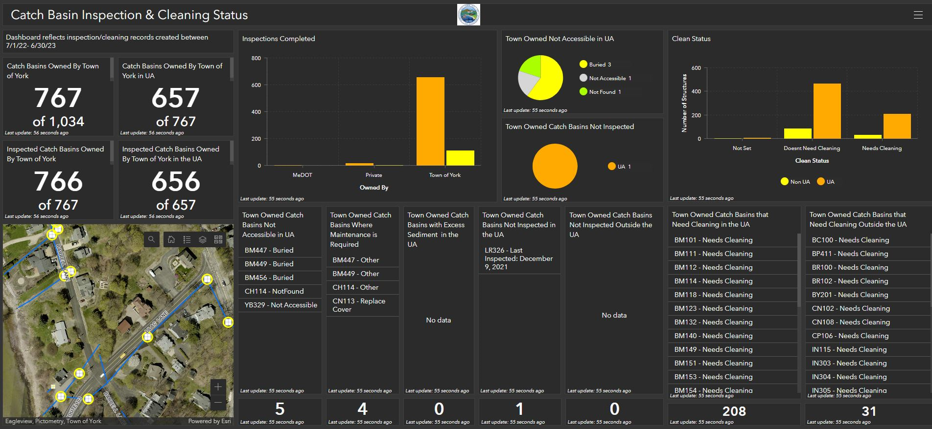
Dashboards are useful for managers responsible for monitoring and maintaining infrastructure systems. Displayed information aids in both communicating and managing field crews. Long term benefits assist in preparing annual and capital budgets.
Contact:
Aaron Weston
Business Development Manager
CAI Technologies
www.cai-tech.com
800.322.4540 x28
direct 603.761.6241
aweston@cai-tech.com