
Through a sequence of articles posted in eSpatiallyNewYork, I have proposed a series of GIS applications which provide a framework for establishing and maintaining GIS/geospatial programs in local governments (villages, towns, cities, and counties) across New York State. These applications areas are referred to as the Geospatial Common Core, many of which are integrated with local government office and administrative business systems. Others are utilized in the support of regulatory reporting programs. Together, the Geospatial Common Core contribute towards building sustainable geospatial capacity for local governments. This is the third installment of the series.
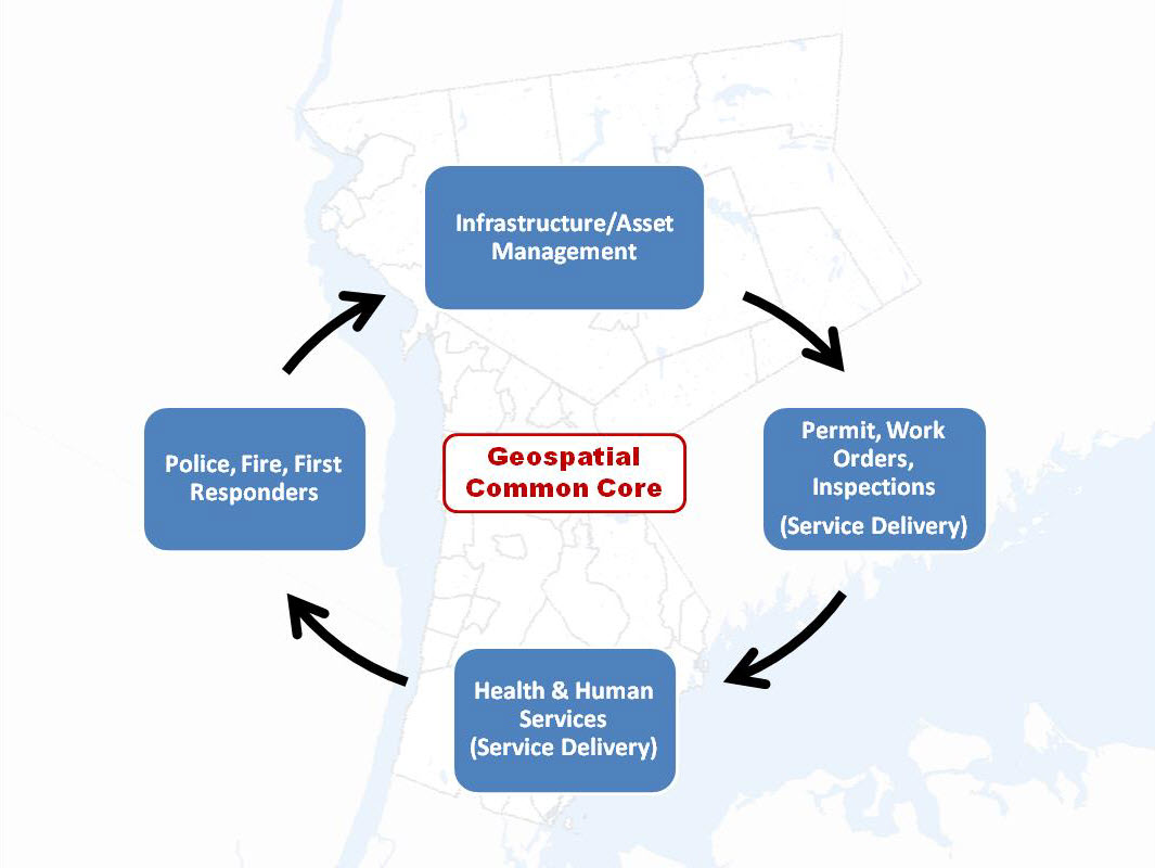
“GIS Common Core” application areas in New York State local governments
The first article entitled Part 1: Infrastructure and Asset Management focused on the growing and critical role local government GIS geospatial programs continue to serve in rehabilitating and maintaining the decaying and outdated New York State – and national – public infrastructure. The second article Part 2: Work Orders, Permitting, and Inspections (WOPI) published in March 2016 focused on geocentric software packages which are ubiquitous in government programs supporting work flows in areas such public works, health, planning, clerk, assessment, buildings/code enforcement and inspections. Organizations investing and integrating WOPI systems with GIS will continue to help build long-term sustainable geospatial programs in local governments.
Part 3: Health and Human Services (HHS)
Health and human services can often be broadly defined from one location to another but for the purposes of this article it includes a wide-range of government programs including, but limited to, public health services, social services, public assistance, youth and veterans programs, disability programs, housing and homeless services, child protection services, as well as the important network of contracted service providers governments rely upon in providing counseling and related support services. I have long been an advocate of building geospatial capacity in these local government program areas.
Why?
Statewide local government HHS budgets typically dwarf other local government operational program areas with regard to annual appropriations. While I am not a budget analyst and admittedly it’s sometimes difficult to follow the money trail of appropriations vs. revenues vs. actual tax payer costs in county budgets, here are a few examples to illustrate the size and magnitude of HHS programs in a selected 2017 NYS county budgets (Data/information from County webpages as noted):
- Stuben County 2017 Budget. (Page 3). Pie chart indicates nearly 47% of the appropriated budget dedicated to Health and Economic Assistance/Opportunity (includes Social Service disciplines) program areas
- Ulster County 2017 Budget. (Pages 1 & 2). Table and pie chart indicate nearly 42% of the appropriated budget dedicated to Public Health and Economic Assistance/Opportunity program areas
- Erie County 2017 Budget. (Pages 93, 159, and 174). Appropriations (rounded in millions) in Health ($86M), Mental Health ($47M) and Social Services ($591M) account for almost 50% of the $1,455,000,000 recommended general fund budget. (Note: There are other references to the 2017 budget being closer to $1.7B). Either way, HHS budgets are a significant portion of the overall county budget
- Albany County 2017 Budget. (Page 34). Employee Count table lists 657 of 2,535 County employees (26%) are in the Child, Youth, and Family Services (170), Social Services (308), Mental Health (90), and Dept. of Health (89)
- Suffolk County 2017 Budget. (Pages 101 and 366). Appropriations (rounded in millions) in Health Services ($249M) and Social Services ($628M) account for nearly 30% of a recommended $2.9B budget
- Monroe County 2017 Budget. (Pages 157 and 275). Appropriations (rounded in millions) in Human Services ($536M) and Public Health ($62M) account for nearly 50% of an adopted $1.2B budget
Challenges
New York State Department of Health (NYSDOH) was one of the major supporters in the initial development of the existing New York State “open data” portals providing increased transparency and accessibility to public health datasets. Today there are at least two primary sites for users to access NYS health data: www.data.ny.gov and www.health.data.ny.gov. There is a plethora of public health data being published in these portals which can be used in local government geospatial applications albeit not always necessarily GIS friendly. New York State government agency data providers could go a long way in providing the data/indicators through the existing portals noted above as a web/map service AND making the information available at smaller units of geography (i.e., municipal, zip code, census track, or better census block group). It’s noted many “health-related” environmental datasets covering the Empire State are available from New York State Department of Environmental Conservation (DEC) and the U.S. Environmental Protection Agency.
On the other hand, County Social Service program databases are much more sensitive with regard to data confidentiality (patient) issues albeit some program areas such as SNAP are publicly available via the state open data portals though only available at the County level. Working essentially as agents of the state in administering most social service programs, counties must conform to a wide range of state-mandated reporting requirements as well as using state-designed systems which provide a slew of technology challenges for use in local GIS/geospatial applications. Particularly in context of preparing, and often generalizing datasets to larger units of geography (i.e., address-based data available as block group data) and/or removing personal identifiers, for use in GIS software applications.
Where’s the Benefit?
While there are still many challenges, geospatial applications in the public health and human services arena provide tremendous opportunities for governments to improve the delivery of services more cost effectively.
"Service Delivery" noun the act of providing a service to customers: Source: Cambridge Dictionary
As itemized above, government programs in HHS are often enormous with football field size floors of case workers and managers in-charge of a broad range of assets including field staff, vehicles, real-time data collection applications, scheduling time-required appointments, coordination of contracted service providers, using government or publically owned facilities (schools, libraries, and community centers), and often requiring the use of public and para-transit transportation systems. To say the least of having to be prepared to answer to an already increasingly internet savvy tax-payer user base looking for government information and assistance 24 X 7 over the internet.
The visualization and analysis of all these geographically based features within the GIS environment can enable HHS administrators and managers to better manage service delivery systems more cost effectively in context of the following examples:
- Assigning appointments/cases/inspections based geographic areas; visualizing data on a map based on heat maps, inspection-type assignments, projects, or case loads is more intuitive and can improve a manager’s ability to better allocate resources in areas of greatest need or priority.
- Developing “traveling salesman” schedules; optimally routing appointments so as to minimize road mileage and travel time from stop-to-stop.
- Using geography as a primary factor in establishing temporary/leased facilities required or needed to support program delivery. More cost effectively establishing temporary support facilities in the geographic areas(s) of greatest need.
Governments can do more to manage service provider contracts which are geographically and optimally located in the areas of greatest need so as to minimize the transportation burden on individuals required to meet with providers for program compliance. In urban areas, working with and establishing service provider contracts which are close to public transportation systems (bus stops, train stations) which can often be of assistance in connecting individuals with their providers.
5. Newer and more cost effective vehicle tracking systems enable managers to make “location-based” decisions to dispatch or re-route field workers when schedules change or there is an immediate need to cover a geographic location. Office managers often have limited or factual geographic information as to what field resources are spatially closest to respond to on-the-fly or emergency incidents;
6. Where data is available, GIS applications can be designed for HHS staff to help determine whether certain types of public assistance are legal or appropriate at a specific address based on local zoning designations. By example, housing assistance subsidies should not be awarded to applicants providing addresses in zoning districts designated Industrial, Manufacturing, or Commercial/Business.
HHS program staff can utilitize GIS technology to help determine the validity of applicant data (re: local address housing use/conditions) by cross-referencing local zoning district maps and associated permitted uses.
7. Mobilizing and automating field data collection work flows. Easy-to-use and affordable mobile apps can now be designed to collect most data electronically minimizing the number of errors associated with paper-based data collection efforts and reducing the need (and time) to key-stroke data into systems after returning to the office.
8. Online resource directories and applications empower residents towards helping make their own decisions/data gathering lessening the need for “staff” assistance from public agencies – particularly during the traditional 8-5 work day.
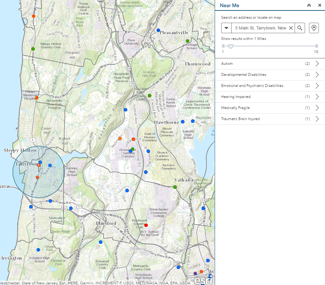
Westchester County Office for People with Disabilities provides an online application which enables residents to identify service providers based on a selected radius search from a given address. Public transportation system components are also included in the application.
9. Location based mapping applications built with GIS software such as ArcGIS enable HHS professionals to conduct powerful spatial and visual analysis on data sets. Such comparable analysis is very difficult to duplicate when the same data is only being reviewed and analyzed in spreadsheets. Location-based mapping software is increasingly being integrated with statistical software packages such as R and SPSS which are common in HHS community. The integration with location based (GIS) and HHS statistical data provide broad and intuitive data visualization capabilities.
10. As illustrated in the following images, local HHS program data can be mashed-up with a variety of state data sets which are increasingly being published via Health Data NY and NY.GOV as well as map services from individual state agencies.

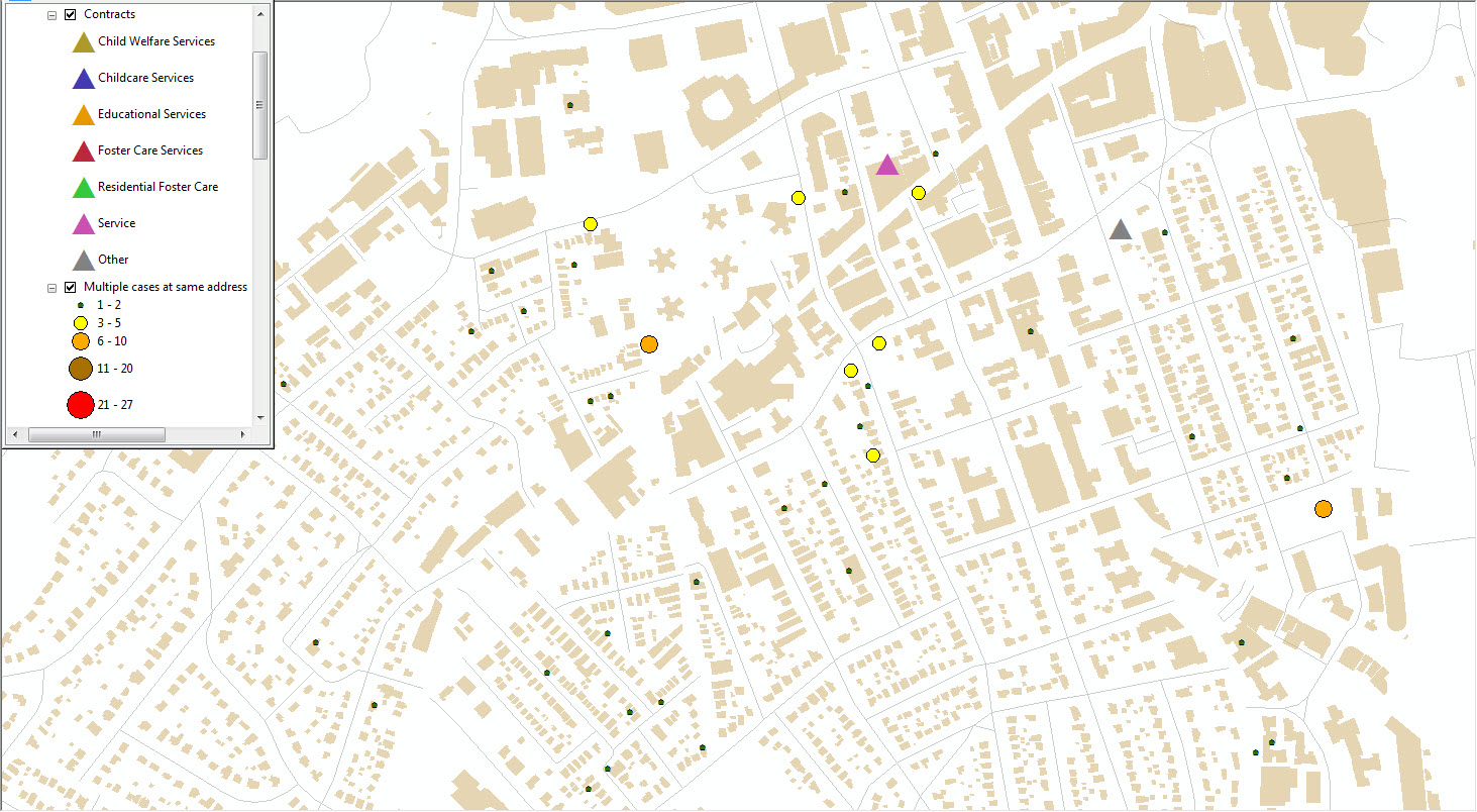
Child and Adult Care Food Program Participation locations in Westchester County as provided by NYS Office of Children and Family Services.
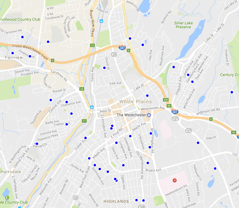
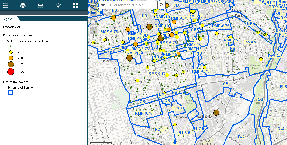
Child Care Regulated Programs in central Westchester County. Data from NYS Office of Children and Family Services.

Local Mental Health Programs in Westchester County and the Bronx. Data from NYS Council on Children and Families.
Summary:
While the actual cost-savings or increased efficiencies HHS agencies in local governments realize by investing in geospatial technology will clearly vary from government-to-government, many of the program areas itemized above provide specific examples of how GIS technology can be applied in New York State local government HHS programs. These are big ticket budgets and just as important for the GIS community – mandated programs. Tax-payer government programs which are not going away and will continue to be significant components of local government budgets. Building geospatial capacity in these program areas, if only in a small context, will raise visibility of each local government GIS program and further institutionalize its long-term value. Its time to get started.
Broad deployment of HHS geospatial applications in New York State, however, will only be realized when there is a more dedicated participation and investment from NY state government agencies which are major stake-holders and data stewards in these systems. To say the least of the NYS GIS Program Office which clearly has other current projects and priorities.
Until this is realized, HHS GIS applications will evolve to some degree across the state at the local level, albeit scattered and not uniform. What is needed are statewide HHS geospatial systems encompassing architecture, data, applications, and funding – and most importantly, local government input.
Let the discussions begin.