
Company Name: Bergmann (GIS Services and Solutions)
Location: Rochester, NY
Website: bergmannpc.com
Employees: 400+
Established: 1980
 Bergmann is a full service, multi-disciplinary design firm employing a wide range of professionals and practitioners in the geospatial industry. The company represents four decades of a culture built on the work of client-focused experts. Its core business segments include Transportation Systems, Civil Works, Building Design, Land Development, Community Planning & Design, and Program Services. Within these areas, Bergmann’s rich portfolio of work features everything from restoration of historical landmarks, to the comprehensive bridge and highway design, to waterfront master planning. Specific client geospatial support services include:
- Client Consulting: enterprise strategy, system planning & GIS coordination.
- Implementation & Support: architecture design, system configuration & optimization & technical support.
- Software Development: software extensions (ArcGIS & Geocortex), custom solutions (web/mobile/desktop) & system integration.
- Data Services: database design, data development, and management & data migration.
The Bergmann GIS Services team is a nationally recognized leader in the field of Geographic Information Systems (GIS). Project Managers, GIS developers, GIS analysts, and 3D Design Specialists offer clients advanced and unique technical skillsets to solve complex information challenges. The company focuses on building strong, collaborative partnerships with clients to create applications, data, and workflows which bring efficiencies and value.
 Bergmann maintains several strategic business partnerships, allowing us to leverage and integrate multiple technologies for clients.
-
- Eagleview-Pictometry Business Partner – 3rd Party Integrator
-
- Latitude-Geocortex Business Partner – Licensed Developer
-
- Motorola Licensed Developer – Intelligent Middleware License
Sample Products and Applications
Erie County New York, Department of Public Works – GIS Implementation
The primary goal of this project was to build a GIS platform at the Department of Public Works (DPW) and develop datasets and applications identified as the highest priority by the Highway Division. By establishing core applications and migrating many disparate datasets into a central database for highway, the Division immediately gained much-needed asset management functionality. Bergmann implemented the following tasks under this project:
- Configured an operations dashboard to bring a common operating picture of live data to the Erie County DPW Maintenance District Engineers, DPW Commissioner, and County Executive for weather events as well as daily work activities. The dashboard brings together numerous datasets derived from multiple sources, including Automated Vehicle Locator (AVL) feeds, traffic cameras, 511 data, weather radar, road closures and various other road construction activities, public complaints, weather event emails, and more.
- Datasets developed: Highway centerlines, Bridges, Culverts, and real-time point locaitons of DPW trucks (via Verizon wireless and ESRI GeoEvent Server), Road Closure(s), and Detour lines
- Customized Geocortex Bridge Inventory Management (BIM) application
For each solution, Bergmann provided end-user training classes to County staff.
Several ESRI technologies were applied to compile the data along with some behind the scenes customization. ESRI technologies utilized as part of the Erie County project began with the county’s existing enterprise geodatabase and expanded through ArcGIS Server and GeoEvent Server, ArcGIS Online maps, Web AppBuilder apps, as well as Operations Dashboards and Survey123.
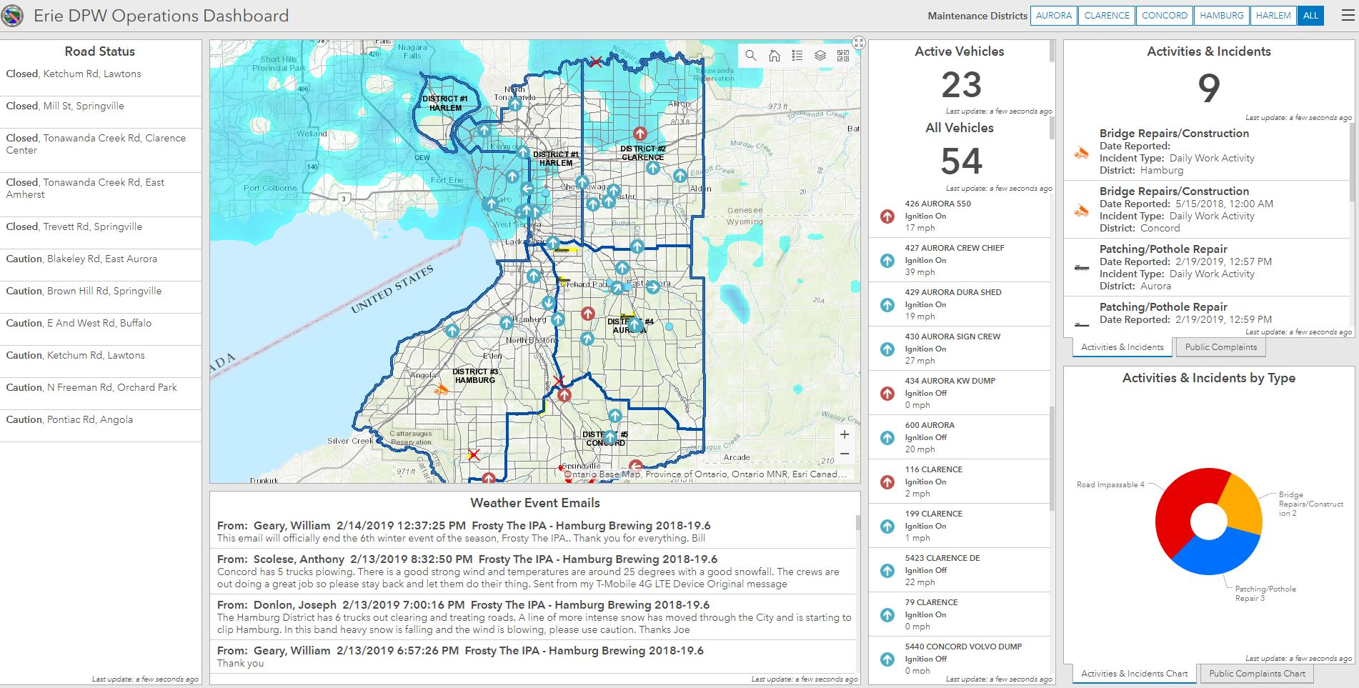
The Erie County DPW Operation Dashboard shows the six county-wide operational districts and includes the display of several live feeds from other real time such as AVL, road closures, and weather conditions.
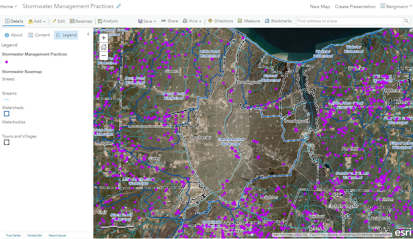
Monroe Stormwater System Mapping
Bergmann assisted Monroe County in developing a comprehensive storm water management practices data set, as well as a web and mobile application to facilitate data management, tracking, and maintenance. The purpose of the data and applications is to help the Stormwater Coalition of Monroe County advance stormwater system mapping and water quality improvement.
A. Requirements Gathering & Process Design: Bergmann, through several requirements gathering meetings, established the data/application requirements and the data collection process from the 29 municipalities of the Monroe County Stormwater Coalition, and the schedule for the project. Bergmann developed a survey for the Coalition members to assess the current status and format of their stormwater practices data, which will advise the process and time needed to gather this data from the municipalities.
B. Data Development: Bergmann compiled data from the 29 municipalities into the county-wide stormwater practices dataset. Bergmann identified remaining data gaps and determined the best approach for capturing the missing data and attributes.
C. Field Inspection Application: Bergmann developed an ArcGIS Collector / Survey123 mobile application to be used by Coalition members to perform annual field inspections of their stormwater management practices. The application was designed based on the demo application developed by the Department of Environmental Services for inspecting County-owned stormwater structures. The app includes permission control that limits Coalition members to view and update only the data that falls within their municipality.
Online applications are cost-effective solutions for multi-government regulatory programs when business work flows and reporting functions are nearly identical for each agency.
Bergmann Survey and Drone Services
Bergmann’s survey and drone services group use state-of-the-art equipment combined with time-tested methods and procedures to achieve the best possible survey results for design and development purposes. Sample projects include:
A. Roswell Park Cancer Institute, Main Hospital Entrance and Utility Survey
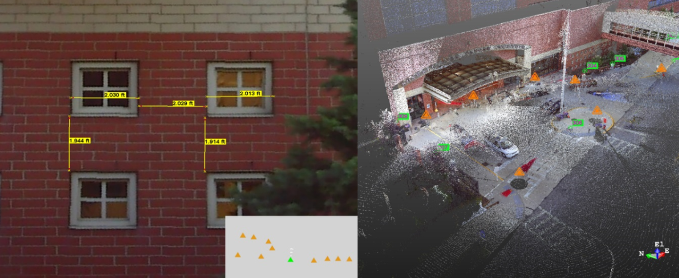
Using a topographic survey and uitility as-builts, Bergmann scanned and mapped the main hospital entrance of the Roswell Park Cancer Institute in 3D. Using the point cloud output rapid and accurate measurements of the building’s features.
B. NYS Office of Parks, Recreation and Historic Preservation (OPRHP), Western Region
The main objective of this project was to perform a pavement evaluation of roadway and parking areas at four parks (Letchworth, Hamlin Beach, Lakeside Beach, and Darien Lakes) in the Genesee Region.
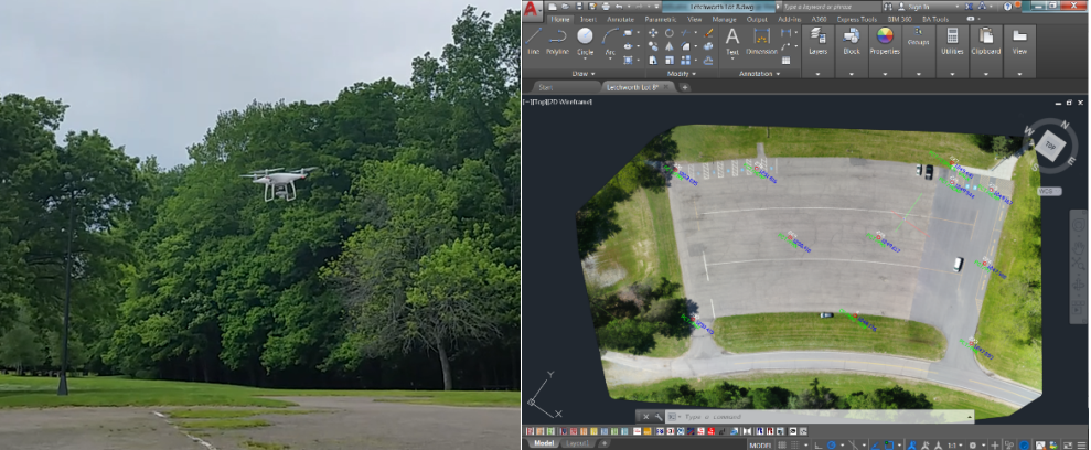
Bergmann surveyed nearly 50 miles of park roads and 25 parking lots using drone technology. The imagery from the drones was used to create the pavement rating conditions.
OPRHP project deliverables included:
- Develop a rating table per roadway and outline areas requiring treatment. Determine rating by area, based on need, issues, and priorities.
- Develop programmatic estimates per area, separating by roadway and/or parking areas.
- Mapping application to view and update the pavement conditions as they are repaired or fall further into disrepair.
Contact:
Vijay Sambandhan GISP
Project Manager (GIS)
vsambandhan@bergmannpc.com
716-710-3947