The County’s Homegrown Application Provides Mapping and Data Collection Support to the Multi-Agency Western New York Stormwater Coalition
 While the Municipal Stormwater Sewer System (MS4) regulatory program may be taking a back seat in focus to COVID-19 across Empire State governments in 2020, compliance efforts nonetheless continue in the background. The DEC program has seen governments responding to meet annual submission requirements in a variety of ways ranging from full vendor supported solutions, hybrid approaches of using in-house resources and commercial-off-the-shelf (COTS) products, while others have built the solution totally in-house. Aka Do-it-Yourself (DIY).
 One such MS4 DIY organization is Erie County which provides administrative and technical support to the Western New York Stormwater Coalition (WNYSC) which has a broad geographic footprint. Erie County took the stormwater management regional lead in western New York in 1999 when it became apparent both Erie and Niagara Counties would be required to come in compliance with the United States Environmental Protection Agency (U.S. EPA) Phase II Stormwater requirements. Recognizing much of the MS4 General Permit was general in context of most permit requirements being the same for all governments, the Coalition was created in 2003 as a means to share work such as public education and outreach, development of policies and procedures, employee training – and mapping. While the Coalition is not an official Erie County government agency, it is housed administratively inside County offices.
Erie County MS4 Support
Initial development of the program started in 2012 by the current Director of Erie County’s Office of GIS, Lisa Matthies-Wiza, who was part of a team that designed databases, field applications, and quality assurance plans to manage data collection. This was facilitated through a series of grants through NYSDEC and partnerships with Erie County and Buffalo State College provided to the Coalition.
More recently, support to the Coalition’s MS4 compliance efforts has been Michael Ruffino who came to the County in March of 2019. Prior to Erie County, he had experience in the use of ArcGIS Online (AGOL) Survey123 and Collector in Chautauqua County where he was able to incorporate similar apps for the environmental health department septic systems and water supply inspections. Currently Erie County hosts all of the GIS data and hardware/software infrastructure for the entire WNYSC program.
Current MS4 Tools and Apps
Although considerable outfall and storm water system data had already been collected upon Michael’s arrival to the County, there was no web presence, online mapping viewers or any data collection applications. Prior to the program’s online presence, the County would send members an ArcGIS desktop generated ‘package’ of all their GIS data, outfalls lists/books, enlarged maps, and map books and data summaries. It was quite comprehensive, especially for being done without a consultant. A sample Town of Eden map book can be downloaded here.
As such, one of the first products Michael developed was the MS4 online viewer which is currently not public facing and only accessible to WNY Stormwater Coalition members. Built in ArcGIS Online with Web AppBuilder the Coalition-wide MS4 application includes over 2,237 miles of storm piping mapped, 473 miles of ditching, 67,196 catch basins 18, 611 manholes, and thousands of other features such as culverts, downspouts, ponds, and other types of pipes. On a smaller scale, even chemical storage locations, fuel pumps and tanks, outdoor washing stations, salt storage were also inventoried.
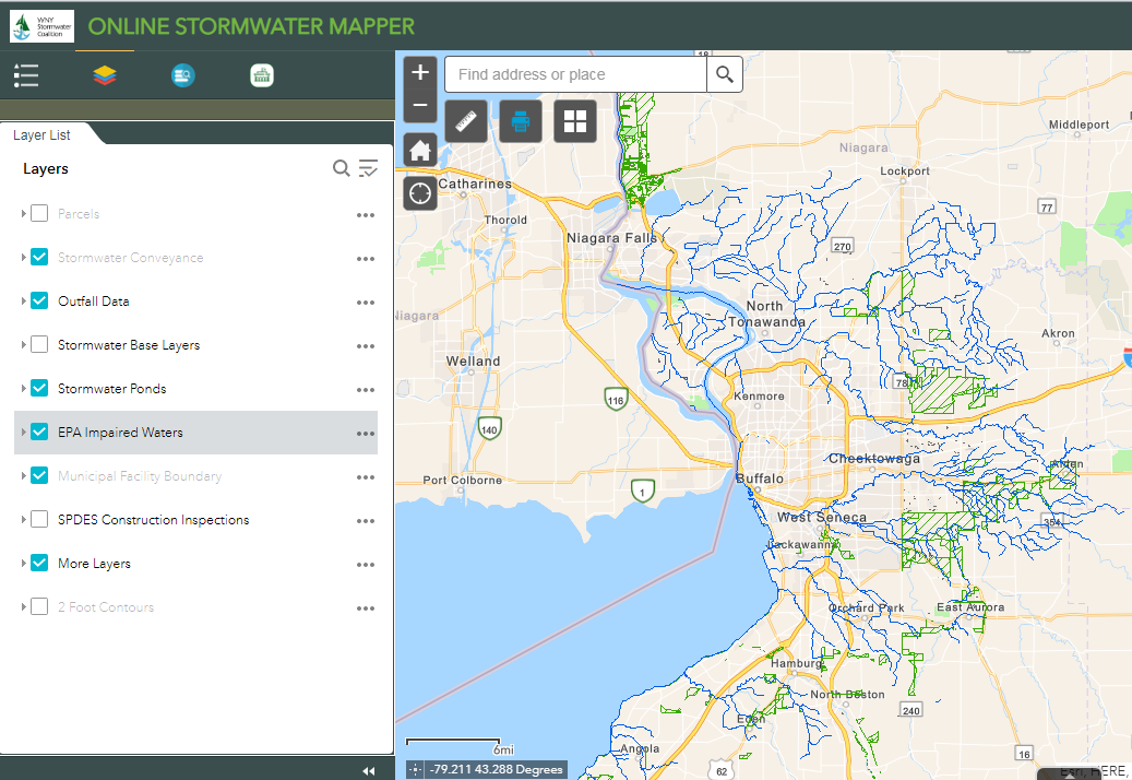
The viewer contains 17 data layers. Including pertinent MS4 collected data, the viewer also provide access to tax parcels, local septic systems information, EPA datasets, and the locations of low infiltrating soils.
All of the system/application data is managed in ArcSDE (actually SQL Server) and is published to s GIS server (ArcGIS Server 10.6) and then brought into ArcGIS Online as a feature service. For quite some time, Trimble XT600 GeoExplorer GPS units have been used to support field data collection (X,Ys) while it is anticipated future GPS units will be tethered to County issued mobile devices (phones) to make higher accuracy data collection more efficient for a greater number of users. Reports are generated with Survey123 feature reports. All of the mobile apps run on both iOS and Android devices. Documentation which is made available for the apps is outstanding via Statement of Purpose (SOP) which is excellent and available to all users. (Example here).
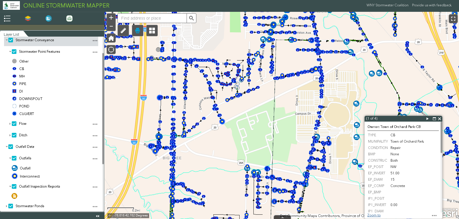
Area near Buffalo Bills Stadium in Orchard Park showing both mapped stormwater conveyance point features and outfall locations. Pop-up box shows data collected on a catch basin owned by the Town.
Use Across the Coalition
A great example of the broad acceptance of the Erie County/WNYSC MS4 model is that the same mobile apps developed by the County – which are used across Coalition governments – are also applied by consultants representing other governments which do not have the capacity to conduct MS4 monitoring and inspection programs. Once an inspection is completed and submitted, the County generates PDF reports of the inspections which are emailed to the requesting organization.
Notes Chris McAuliffe, Code Enforcement Officer, and Town of Lewiston: “I have to inspect 20% of our outfalls a year. I love how the GPS feature marks my exact spot while conducting an inspection. I can attach the picture within the program, and comment on what deficiencies were observed. Outfall inspections and construction observations aren’t that helpful in a filing cabinet. If I’m out in the field and need to access previously-submitted reports, they are now instantly accessible.” And Tim Zuber, P.E., Wendel adds “The products Michael has developed for our Western New York Stormwater Coalition have been of great value myself and other individuals involved with our local MS4’s. Web Map Applications have allowed us to shed the standard paper maps for digital maps available at the click of a mouse or tap on a smartphone. Having readily accessible and current information quickly available definitely helps expedite field inspections. Michael has also created smartphone applications that expedite inspections such as a digital version of the construction stormwater inspection report and digital checklist for outfall inspections. These tools have been invaluable in our day to day MS4 operations.”
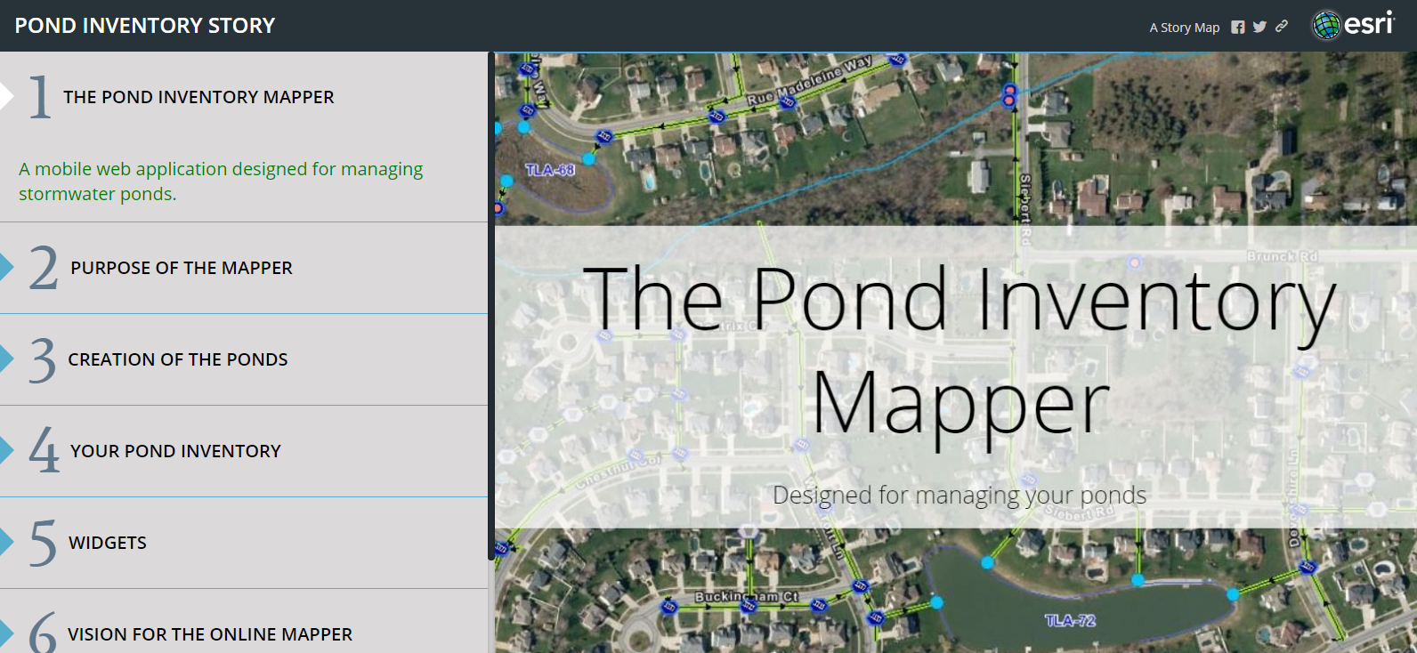
As part of the County’s support to the Coalition, Ruffino also developed a ‘pond inventory application’ to help municipalities identify/inventory stormwater related ponds. Here’s a link to the project Story Map.
Summary
Erie County’s implementation of MS4 support to the WNYSC highlights the growing use of innovative and cost-effective web-based geospatial technologies. New York State county governments often have the infrastructure which can be extended to support smaller units of government (village, town, and city) which have similar or nearly identical business needs. And in this case all the better in that the effort helps support the needs of two counties. Such efforts no doubt require considerable coordination and cooperation on many levels, but at the end of the day save tax payer dollars and the unnecessary duplication of applications and systems. Matthies-Wiza summarizes quite well:
“As both Director of County’s Office of GIS, and as a tax payer, it is gratifying to see that work providing the foundation for the mapping and inspection applications Michael Ruffino has built for the Coalition continues to provide cost-savings to the residents of western New York State”.
Contact:
Michael Ruffino | Planner – GIS
Erie County | Environment & Planning
95 Franklin St.| Buffalo, NY 14202
P:+1(716)858-7760 | michael.ruffino@erie.gov
Lisa Matthies-Wiza, Director, GISP
Erie County Office of Geographic Information Services
95 Franklin St, Buffalo, NY 14202
716.858.8555 | lisa.matthies-wiza@erie.gov