Its not too often one bumps into New York State Liquor Authority (SLA) GIS staff along the geospatial trail across the Empire State, but over there on the sidelines, agency staff continue to maintain an admirable web mapping application entitled New York State Liquor Authority Mapping Project (LAMP). I was able to catch up with William Cowley, Public Information Officer for the State Liquor Authority (SLA), to find out more about the 2021 release of LAMP.
Current LAMP Application
With the current version of the application finalized in March of this year, LAMP features an impressive tool kit to explore the vast statewide SLA database containing locational data on active, pending, and inactive permit data for beer, wine, and liquor establishments. The data can be filtered even more specifically to show those locations which are categorized by:
- On Premise Liquor
- On Premise Wine
- On Premise Beer
- Off Premise Liquor
- Off Premise Wine
- Off Premise Beer
- There are also permits for manufacturing and wholesale
In addition to serving as a great public information outreach tool, the application also serves as a useful utility and reference tool for applicants seeking a liquor license anywhere in the state. The user online HELP documentation is excellent and available for download as well.
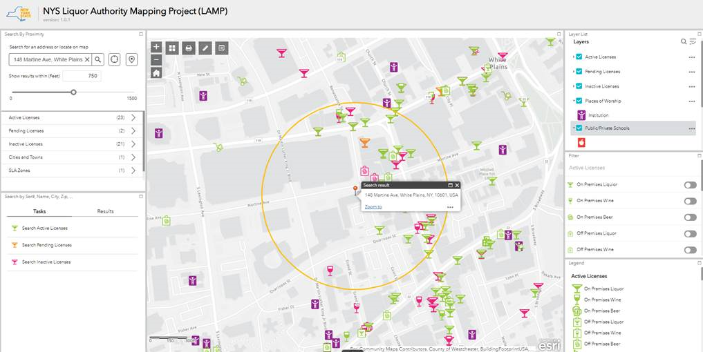
A 750-foot default search around 148 Martine Ave. in White Plains identifies 23 locations with active NYS liquor licenses, two pending, and 21 former or inactive licenses. Icons are colored coded to match active, pending, or inactive licenses keyed to the Legend box in the lower right-hand corner of the viewing screen (which can be expanded on the live online version).
Nearing almost ten years old, LAMP was originally launched in February 2012. SLA staff assisted in the original development and launch of LAMP with consultant support from Fountains Spatial. The 2021 LAMP update was completed with the assistance from Troy-based Cogent Technologies. The viewing application is built on top of a customized version of ArcGIS Online (AGOL) and utilizes a SQL database to store SLA master data. Updated daily, the application contains approximately 54,000 active and pending licenses. The database is built on top of the application process which starts here. The site makes use of the New York State Geocoding Service with the Google geocoding service as a backup. LAMP is hosted by New York State Office for Information Technology Services.
Mapping Tools
The viewer includes an impressive user toolbox with several functions being AGOL defaults (i.e. scale dependency of map features, identify tools, . Others have been customized to provide increased functionality and use of the data. While changing base maps, scale dependency rendering of data, searching by address or user placed pin, or exporting search results to a CVS file are standard AGOL fare, LAMP offers some cool extended functions including, but not limited to:
-
- Query results displayed as a new layer in map legend
- Customized symbology for all feature types
- A “measuring” tool which creates both a list of the closet (8) licensed facilities as well as within the 200’ and 500’ regulatory buffer areas (see below). A sample of a proximity report can be downloaded here.
- An uber robust printing tool with advanced functions to create hardcopy maps
- Easily include and attribute table view – below the main map window – of a particular layer
There are many other functions well documented and available in the application as well.
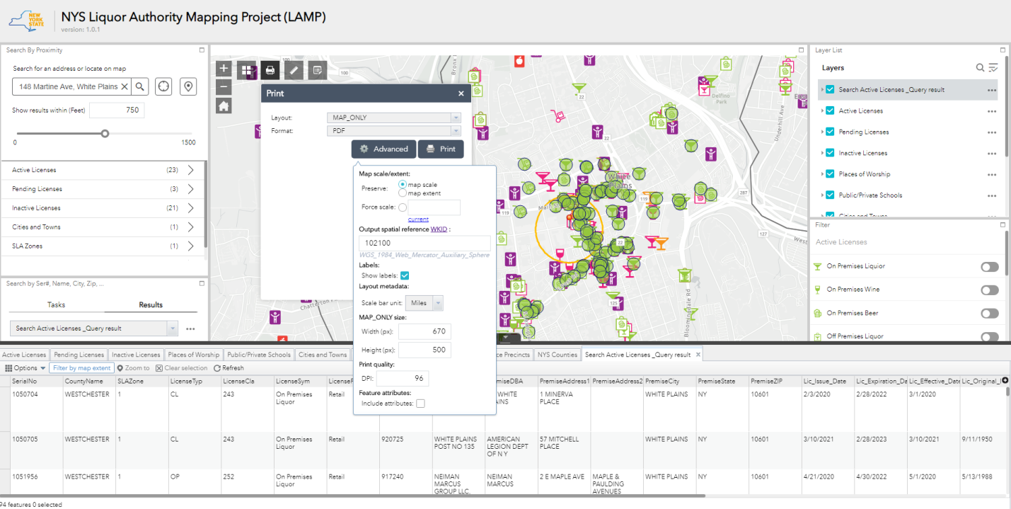
Image above highlights customized features in the LAMP application including expanded printing functions and creating new layers which are shown in the layer legend.
While the permitting process does not require the use of LAMP, most applicants find it useful to identify prior licenses at their chosen location. The locations of Public/Private Schools and Places of Worship are also included in the application because under the Alcoholic Beverage Control Law, SLA may not issue full liquor licenses (for bars/restaurants or for liquor stores) if the location is within 200-feet of a school or place of worship. There is also a “500-foot law” which the agency must consider if there are already three or more active liquor licenses within 500 feet of the proposed location.
Integration with SLAM
In an interesting use and application of the SLA database, reference is made to BetaNYC’s SLAM viewer. Used by community boards when reviewing liquor license applications and sidewalk cafe applications, the public facing tool aggregates information about active liquor licenses, sidewalk cafe licenses, 311 complaints about bars/restaurants/clubs, and restaurant health inspections in NYC onto a single map. Statewide liquor licensing data can be downloaded from Open Data NY here.
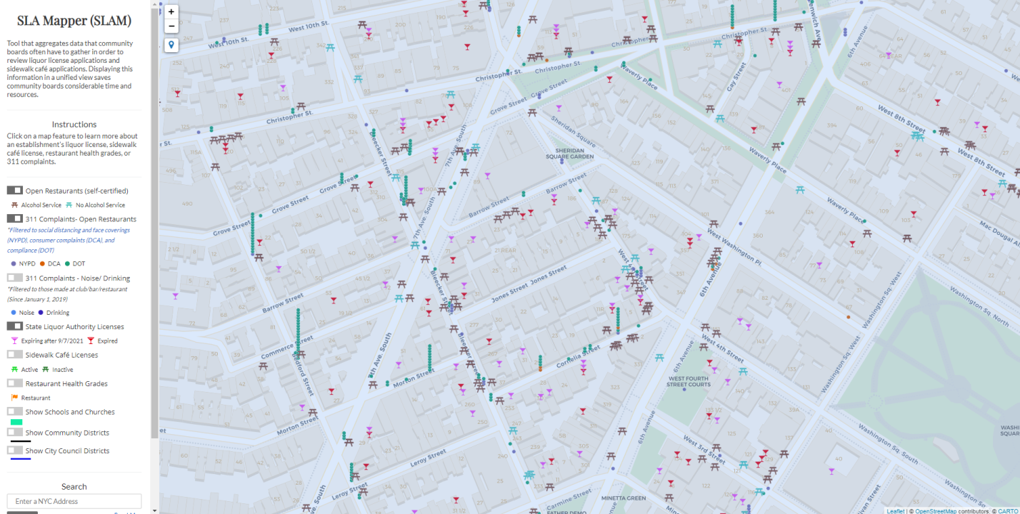
SLAM effectively integrates numerous open data datasets including those from New York City and SLA. Users can zoom to particular addresses and click on relevant features to collect information that may be needed to review a license application. The tool is rendered through Carto – a Web mapping service
Contact:
William Crowley
Public Information Officer
New York State Liquor Authority
William.Crowley@sla.ny.gov