Background
Since 2007, the New York Natural Heritage Program (NYNHP), through a contract with the NYS Department of Environmental Conservation, has been managing the statewide administration of the iMapInvasives program. The program is a GIS-based, online, all-taxa invasive species database and mapping tool which is used across the state for the collection, distribution, and analysis of invasive species observation, survey, assessment, and treatment data. Use of the program by individuals and partnering organizations helps coordinate the early detection of invasive species and rapid response efforts though email alerts and other outreach efforts. The application facilitates communication among individuals, partners, and organizations working to protect the natural and agricultural resources of NY state from the impacts of invasive species.
Statewide invasive species management is implemented through eight PRISMs (Partnerships for Regional Invasive Species Management). The PRISMs have many responsibilities, such as to plan regional management, develop early detection and intervention plans, coordinate control and eradication projects, educate, coordinate with partners and other PRISMS, recruit and train volunteers, and support research efforts.
Watercraft Inspection Steward Programs (aka Boat Launch Stewards Program)
Recreational boating has been identified as a key pathway in the spread of aquatic invasive species (AIS) across New York State. The Aquatic Invasive Species Management Plan was adopted by New York State DEC in July 2015 to clearly outline the AIS strategies utilized throughout the state. New York is particularly vulnerable to AIS due to the easy access that ocean-going vessels have to the Great Lakes and the ease by which these species can spread via the state’s canal system. Aquatic invasive species can also find their way into New York State through the live animal, nursery, and landscape trades. Once in New York State, AIS are primarily spread by humans, either purposely though their direct release, or incidentally through recreational boating and angling. Note that aquatic invasives can be transported via “other” recreational watercraft such as windsurfers, kayaks, and canoes, too.
Watercraft inspection and associated steward programs are critical components in protecting aquatic ecosystems and water quality by preventing and limiting the spread of aquatic invasive species among waterbodies in New York State and neighboring states and provinces. Many organizations across NY have had boat launch stewards positioned at boat launches for years. The boat launch stewards gather information about boater’s knowledge of invasive species and check watercraft for fragments of invasive organisms. Tracking reports of different species and how frequently different locations are used by water recreationists is important for prioritizing outreach and control efforts and for choosing boat launches that allow stewards to reach the most recreationists and reduce risk of introduction at high use launches.
Watercraft Inspection Steward Program Application (WISPA)
Continuing their leadership role in invasive species tracking and monitoring in this space, NYNHP took on a new database project when asked by Parks and DEC in 2017 – the Watercraft Inspection Steward Program Application (WISPA). WISPA is an ESRI Survey123 app which provides a standardized platform for collecting boat launch steward data. “We are honored to be working with such a proactive, and well-organized group effort”, said Meg Wilkinson, Invasive Species Database Program Coordinator at NYNHP. Supporting NYNHP is NYSDEC Division of Lands and Forest – Bureau of Invasive Species and Ecosystem Health and the New York Sea Grant on Aquatic Invasive Species program, as well as numerous participating organizations (see below). “WISPA data does not go into iMapInvasives”, Meg pointed out, “because finding a piece of water chestnut on a boat cannot be entered as an invasive species observation into iMap. However, WISPA is a great platform for aggregating this very important invasive species prevention effort data”.
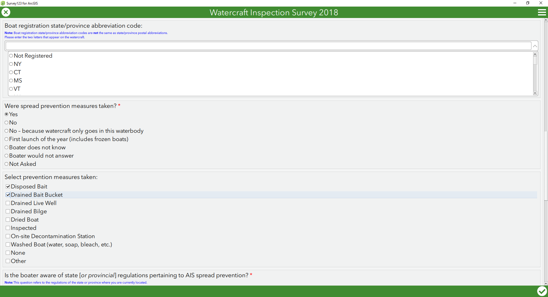
Some sample questions from the WISPA mobile app including state of boat registration and invasive spread prevention measures taken (yes/no and type).
The initial application provided a platform for building a watercraft inspection program which was used by nearly 80 lake stewards across the state ensuring consistent and desired data about water recreationist travel, aquatic invasive species awareness, what species were found on watercraft, and if boaters are making an effort to “clean, drain, and dry” their watercraft as required by 6 NYCRR Part 576. During the pilot 2017 season, over 32,000 surveys were collected which included nearly 4,000 reports of invasive species. The most common invasive species detected was the plant Eurasian watermilfoil (Myriophyllum spicatum).
This year WISPA includes nearly 240 boat launch stewards across the state deploying the app. They record information about their visits with boaters, including asking if they can inspect the boat, if the boater is aware of invasive species, and if the boater regularly takes invasive species spread prevention measures. Boat Launch Stewards upload their collected records each night to the AGOL Survey123 WISPA site, which are then reviewed by the local “WISPA Leader”. The WISPA dashboard displays some key statistics for WISPA Leaders, DEC staff, and NYNHP’s “iMap Team” to review, providing an easy way to see if there are any issues or anomalies which need to be addressed. Any high priority “hits” are being followed-up on immediately by appropriate AIS staff.

Map showing the locations of selected 2018 data collection points as rendered through ArcGIS Online. The map includes a feature service provided through AGOL called “WISPA Editor Map” that allows WISPA Leaders to edit, export, and analyze data submitted on behalf of their organization.
Per the screenshot below, as of July 1, nearly 55,500 records have been collected through the WISPA program as part of the 2018 summer season. Of the records collected, 3,842 include the detection of invasive species. As might be expected, a majority of the watercraft (est. 75%) are motorboats with a New York license tag. The top two invasive species being detected are Curly Leaf Pondweed (1,460 records) and Eurasian watermilfoil (1,400 records). The boat launch with the most records collected is Saratoga Lake.
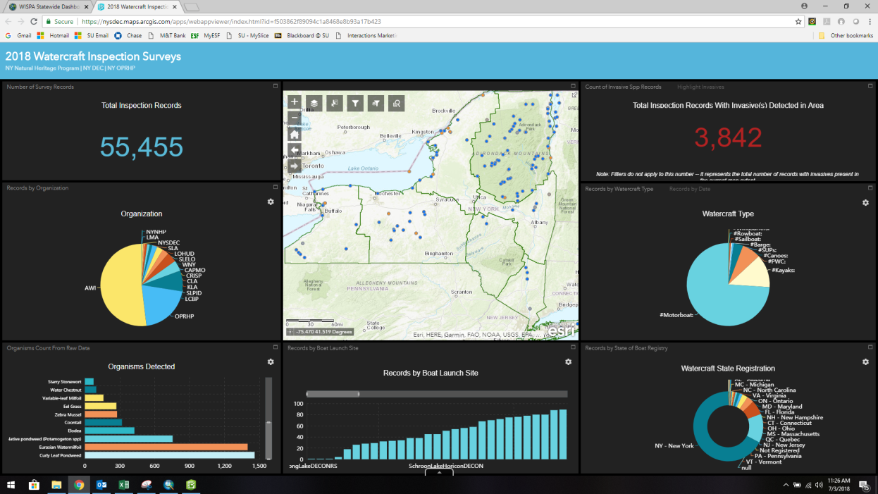
The WISPA app dashboard includes visual tools which display the statewide dataset. Dashboards are increasingly being integrated into geospatial applications providing a range of analytical tools and easy-to-read charting functions.
There were many lessons learned as part of the initial 2017 WISPA implementation. John Marino, of NYNHP and GIS Applications Developer for the WISPA app, notes “One of the primary goals between 2017 and 2018 was to provide a common platform with ArcGIS Online – easy to use in the field – which program coordinators and leaders could use to review and edit data submitted on behalf of their organization in real-time. Analysis of the 2017 data was done after the season.” Cathy McGlynn, Aquatic Invasive Species Coordinator at DEC, adds “In 2018 we are testing WISPA’s ability to accommodate a larger number of organizations and their needs and also beginning to understand how having real-time data about identifying AIS and boat launch use will improve our ability to protect New York State’s water resources.”
Over time, invasive species data collected as part of the WISPA program will be cross-referenced and compared with data collected through the iMapInvasives program. It is possible, for example, certain WISPA data “hits” (e.g. a water chestnut fragment found on a boat being retrieved from a waterbody) could be a helpful tool for invasive species early detection work. However, work and research on a pilot project in this regard are still in the early stages by NYNHP and DEC staff. Depending on results of the pilot, and feedback from the PRISM Leaders, this analysis might move to full implementation for the 2019 field season. WIPSA data being collected may also be able to show how individual watercraft types are involved in transporting AIS from one water body to another.
The Watercraft Inspection Steward Program is implemented by numerous partner organizations and state and federal agencies to track and analyze invasive species trends to aid in prevention, education, and treatments across the state. Current partners include:
- The Partnerships for Regional Invasive Species Management (PRISM) participating organizations
- Adirondack Watershed Institute, Paul Smiths College (stakeholder in the Adirondack Park Invasive Plant Program (APIPP)
- Capital Mohawk (CapMo)
- Catskill Regional Invasive Species Partnership (CRISP)
- Finger Lakes (FLI)
- Long Island Invasive Species Management Area (LIISMA)
- Lower Hudson/Clearwater SLOOP (LWRHUD)
- Lawrence Eastern Lake Ontario (SLELO)
- Western NY (WNY)
- Chautauqua Lake Association (CLA)
- Keuka Lake Association (KLA)
- Lake Champlain Basin Program (LCBP)
- New York State Department of Environmental Conservation (NYSDEC)
- New York State Office of Parks, Recreation, and Historic Preservation (OPRHP)
- Skaneateles Lake Association (SLA)
- Saratoga Lake Protection and Improvement District (SLPID)
- Lake Moraine Association (LMA)
Requirements to participate in the WISPA program include a WISPA Designated Leader (Organization Member), an ArcGIS Online Named User Account (to authenticate ArcGIS Online to access the WISPA data that is being hosted on the NYSDEC ArcGIS Online Organization), tablets or mobile/smartphone devices (Android or Apple), and required in-person meetings twice a year.
More Information
The following resources are available for organizations interested in learning more about what is involved in participating in the WISPA Project.
- NY WISPA Project
- Survey123 for ArcGIS
- NYS DEC Aquatic Invasive Species Boat Steward Program
- SeaGrant Getting Started: How to Start a Watercraft Inspection Steward Program
- SeaGrant New York State Watercraft Inspection Steward Program Handbook
- New York Invasive Species (NYIS) Information
- NY iMapInvasives database and mapping system
To become a participating member of the WISPA program in 2019, please contact the New York Natural Heritage Program iMapInvasives Team at imapinvasives@nynhp.org.
eSpatiallyNewYork acknowledges conrtibution of Meg Wilkinson and NYNHP/DEC staff in the development of this article.