
Company Name: CycloMedia Technology Inc.
Location: Berkeley, CA
Website: www.cyclomedia.com
Employees: 120 Globally
Established: 1981
A privately held company, founded in the Netherlands over thirty years ago, CycloMedia Technology, Inc. is a rapidly expanding international company with staff in Syracuse, New York. Annually, CycloMedia captures and processes approximately 160,000 linear miles of 360° panoramic street level images, representing over 48 million recordings per year. The company holds five key image capture technology patents and specializes in the local government market. Currently the company has projects with the cities of New York, Philadelphia, Washington DC, as well as Franklin County, OH (Columbus), Dakota County, MN (Minneapolis) and Jefferson County, KY (Louisville) to name a few.
Specific benefits of Cyclomedia technology include:
- GeoCyclorama images and basemaps are geographically linked
- Provides ability to conduct searches with address, postal code or coordinates
- Integrate with interprise applications and work processes using the GlobeSpotter API
- Determine the location and dimensions of objects in GeoCyclorama imagery
- Ability to create precise point, line and area measurements
- Overlay enterprise spatial data on the GeoCyclorama images
- Supports Open Geospatial Consortium (OGC) standards
- Integrate data in formats such as WFS, WMS, Shapefile and GML
- Create reports and bookmark locations of interest
- Users can save and utilize GeoCyclorama images for reporting and analysis functions.
Geospatial Products and Services:
A. GlobeSpotter
GlobeSpotter (web) is an interactive web-based application that provides cloud access to GeoCyclorama imagery and tools for measuring, collecting data, and reporting. The software and data are directly available from CycloMedia’s software as a service (SaaS) model.
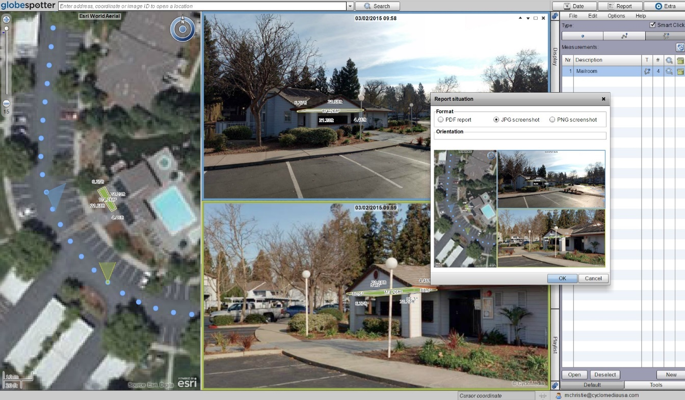
GlobeSpotter (web) screenshot with area measurement and reporting window
GlobeSpotter for ArcGIS Desktop provides visualization, measurement and overlay tools within the ArcMap or ArcGIS Pro allowing a user to fully leverage the power of GeoCycloramas within the ArcGIS client environment. Specific capabilities include:
-
- Open GeoCyclorama imagery from a recording point layer added to the map
- View one or multiple GeoCyclorama images
- Measure on GeoCyclorama images
- Use the native editing capabilities of ArcGIS to collect features in 2D or 3D
- Ability to save and utilize GeoCyclorama images for reporting and analysis functions.
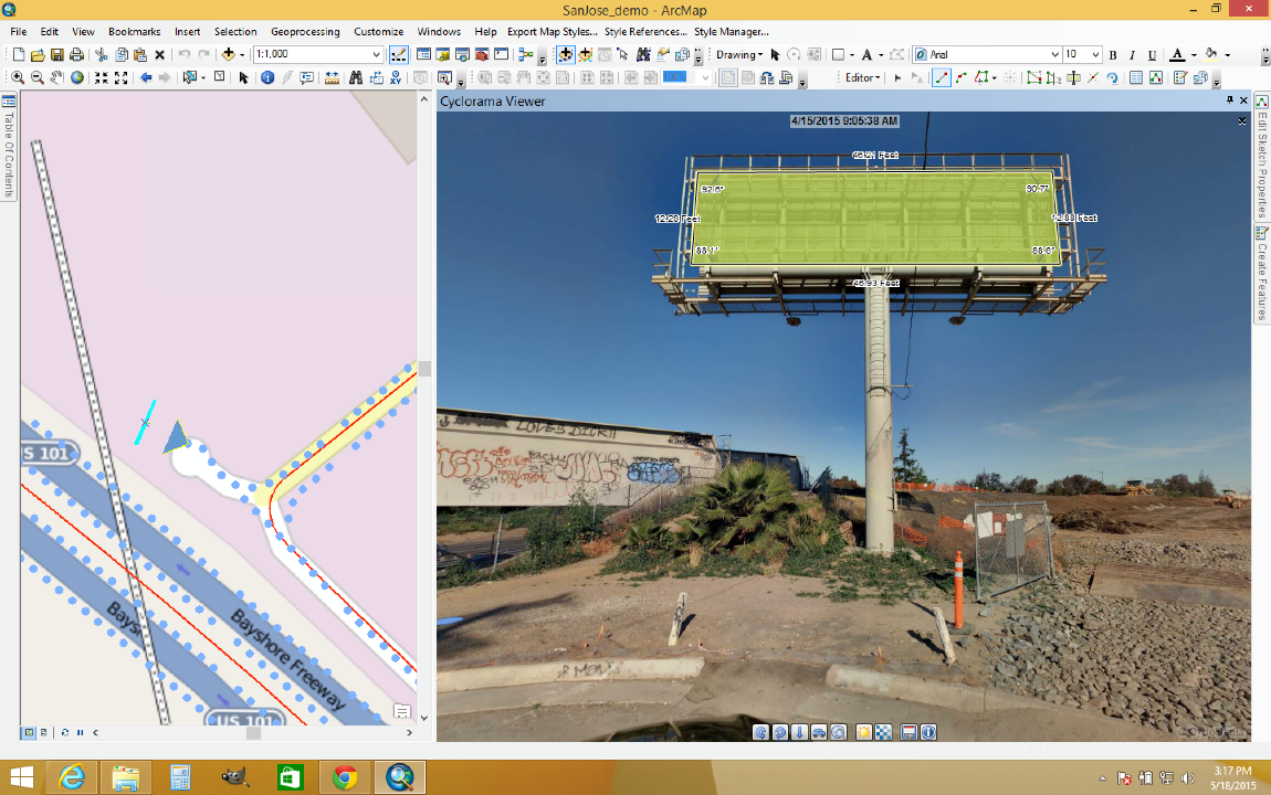
Onscreen measurements within ArcMap are automatically saved in the user Geodatabase
B. Street Smart
This new interactive web viewer built on HTML5 technology provides cloud access to GeoCycloramas and other geospatial tools. Illustrative tools include:
-
-
- Use Street Smart on the desktop or tablet
- Conduct searches with address, postal code or coordinates
- Integrate with your own applications and work processes using the Street Smart API
- “Time travel” to see GeoCyclorama images from previous dates
- Ability to save and utilize GeoCyclorama images for reporting and analysis functions. Measure Smart easy-to-use measuring capability within Street Smart requires LiDAR data
-
Street Smart for ArcGIS Online is for ArcGIS Online subscribers which integrates GeoCyclorama display, point feature editing, and measuring into ArcGIS Online.
-
-
- Add recording point layer to web map used in the application
- View feature services as overlays on GeoCyclorama images
- Edit point features and attributes
- Take linear measurements
-
C. Street Smart Widget for Web AppBuilder for ArcGIS
This tool allows users and developers to bring GeoCyclorama display into applications created using Web AppBuilder with the Street Smart widget. This functionality includes:
-
-
-
-
- Add recording point layer to web map used in the application
- View GeoCyclorama imagery
- “Time travel” to see GeoCyclorama images from previous dates
- Ability to save and utilize GeoCyclorama images for reporting and analysis functions
-
-
-
D. Street Level LiDAR Services
CycloMedia Technology, Inc. brings the added benefit of capturing LiDAR data simultaneously while capturing our GeoCyclorama imagery. This coincident capture method ensures the highest levels of both quality and accuracy. CycloMedia further enhances the LiDAR data by processing it with proprietary CycloPositioner software to increase its locational accuracy and perfect alignment in 3D space with the imagery. Given the precise imagery co-referencing, the process enables the extraction of the RGB values to produce a photo realistic “colorized point cloud.”
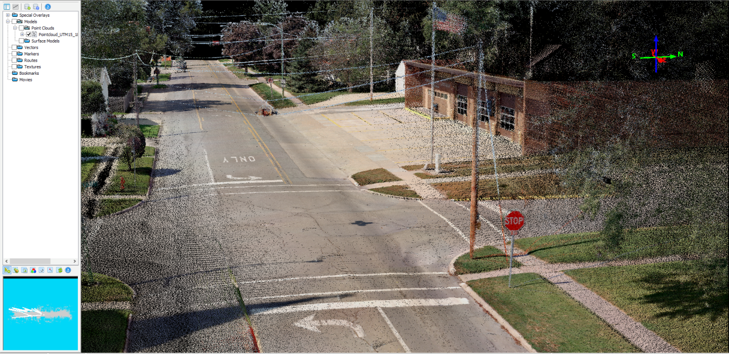
Example of a CycloMedia “Colorized Point Cloud”
Selected Applications:
Cyclomedia continues to support a wide range of government and business applications. Illustrative program areas and specific applications include:
Property Assessment and Building Departments
-
-
- Property Value Determination
- Meets IAAO Specifications and Standards
- Allow for desktop appraisal resulting in a reduction in physical on-site inspections.
- Highly Accurate Measurement Tools, distance, height, area, etc.
- Integration into existing CAMA Systems
- GIS Overlay Capability
- Catastrophic Event Imagery Capture
- Integration with Buiding and Code Enforcement
- Identification and classification of building conditions.
- Significantly reduces code enforcement work from days to hours
- Property Value Determination
-
Public Safety
-
-
- Situational Awareness
- “Boots on the Ground” ground-level view of incident location
- Clear identification and mapping location of hydrants, alarm boxes, manhole covers etc.
- Use Measurement Tools to measure height of physical features, i.e., fences, windows, etc. from ground level.
- On-screen measuring capabilities
- GIS data overlay capability , ie. flood and surge zones, tax maps and cadastral datasets, community facilities, schools, hazardous materials, etc
- Catastrophic Event Imagery Capture
-
Community, Health & Environment Planning
-
-
- Pre-planning and modeling of proposed projects
- Integration with enterprise environmental datasets and monitoring sites
- First Floor Elevation/Flooding Analysis
- Analysis of pervious/ impervious surfaces
- Location of Cooling Towers – Possible Legionella collection area.
- “POD” (Point of Distribution) Planning
-
Public Works and Engineering
-
-
- Significant Productivity Increase
- Three hours of asset collection on one street, reduced to 10 Minutes.
- Administration and implementation of Capital Improvements
- Utilization of Measurement tools – location of water meters, distance of water meters from trees, adjustment of storm drain, catch basin layers
- Visual inspection and validation of customer complaints while customer is reporting the problem.
- Accurate identification of objects missed when only working with aerial imagery
- Street Feature Asset Management (trees, furniture, poles, signs)
- Sidewalk Inventory Assessments
- Integration with AutoCAD and related systems
- Road Condition Assessment
- Road Marking Assessment & Inventory
- Significant Productivity Increase
-
Contact:
Frank Daly
Senior Sales Executive
1.315.380.7110
FDaly@cyclomedia.com I www.cyclomedia.com
Syracuse, New York