
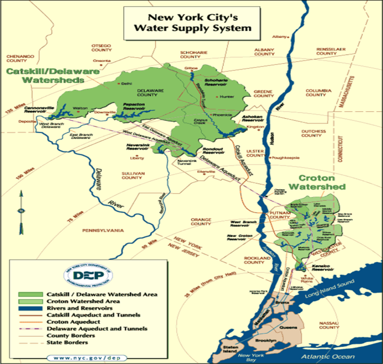
The New York City Watershed is the largest unfiltered surface water supply system in the United States. Every day this region in upstate New York’s Catskill Mountains provides more than a billion gallons of clean drinking water to the more than nine million people residing in New York City and upstate counties. The system includes 19 reservoirs, three controlled lakes, and a watershed that spans more than a million acres. In some cases, water travels more than a hundred miles to reach New York City. While other large US cities typically own the land that drains into their reservoirs – New York City’s lands are unique: Nearly 75 percent of the watershed lands are privately owned with NYC and the State of New York owning a mixture of the remaining lands. Consequently, New York’s water quality depends in large part on the actions of the 30,000 landowners who live, work, and recreate on watershed lands. Overall, nearly 70% of the watersheds are forested with the remaining lands in predominately agricultural use.
The Watershed Agricultural Council (WAC) is one of two primary watershed partners (Catskill Watershed Corporation being the other) locally-based not-for-profit corporations specifically created to assist New York City Department of Environmental Protection (NYCDEP) with the administration and implementation of watershed protection and economic development programs in its water supply lands. The WAC is involved primarily with natural resource and land conservation programs, whereas the Catskill Watershed Corporation primarily oversees community infrastructure and economic development programs. Many other watershed partners serve in various capacities, such as oversight, advice, public education, and communication.
WAC Geospatial
WAC GIS and geospatial applications are built to support four major program areas within the NYC watershed lands: Forestry, Agriculture, Conservation Easements, and Economic Viability. Managing these applications and infrastructure in their three offices [(Walton, Hamden , and Yorktown (East of Hudson)] is the responsibility of Nadine Trahan who joined WAC three years ago after having attended both undergraduate and graduate school in New Zealand. Nadine developed and maintains a ESRI Geodatabase to support enterprise geospatial applications. She notes wireless connectivity and high speed internet connectivity can be a “challenge” in the rural Catskills which plays into the deployment of the enterprise applications. Given the connectivity issues, Nadine uses ArcGIS Portal to design and download applications to mobile devices for in-field deployment: Data collected remotely is synchronized with the enterprise geodatabase when field devices are connected to the network upon return to the office. She currently supports approximately 40 users involving everything from high-end client software apps to browser-based applications for the more casual user. This later category of user being staff which use an internal web map to edit point locations of Pure Catskills members as part of the Economic Viability focus.
Progam Areas
Agriculture
WAC’s Agricultural Program (WAP) utilizes GIS on a daily basis, in order to fulfill program objectives, for 375 farms, covering roughly 150,000 acres. Illustratively, Nadine has developed data management, analysis, and mapping tools for planners working with land owners on Nutrient Management Plans (NMP) and other Best Management Practices (BMP).
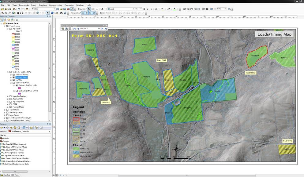
Nutrient Management Planning Template comprising Data Driven Pages (and associated definition queries), relevant landscape data and custom tools to support planning workflows
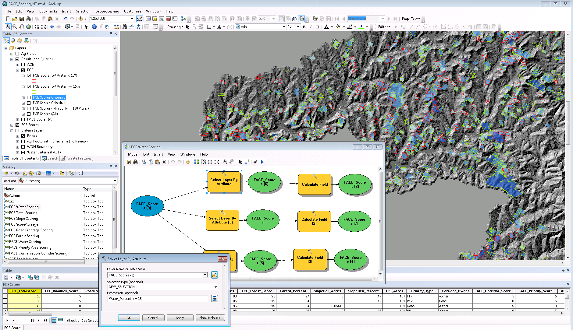
Most commonly used by the NMP Team, is the Nutrient Management Planning Template, designed to support the team’s workflow in developing plans every 3 years per farm. At the core of the template is an ArcMap document comprising virtually all of the geospatial data required to understand farm landscapes and determine where farmers should and should not perform certain activities (e.g. fertilization, manure storage, etc. ) to protect water quality. Using data driven pages, non-technical staff can easily access a farm’s fields and other data, by simply entering into the Farm-ID. Definition queries are set for all layers so that only the specific farm associated with the ID is drawn. On the lower left hand side is the toolbox containing Model Builder and/or Python tools, which further streamlines the workflow (e.g. consistently names and saves the mxd in appropriate directory) and run more complex analysis such as obtaining the area for predominant soils per agricultural field.
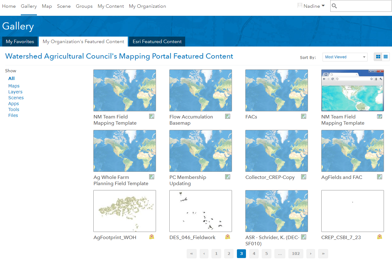
WAC’s Internal Mapping Portal is used to share geospatial information across 3 offices and to take into the field for farmer collaboration, data verification and on the spot geospatial analysis
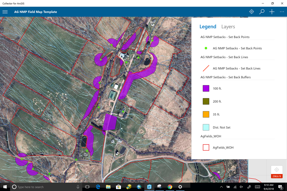
Example of the Collector App Map Template, providing NMP planners the opportunity to visualize and edit data in the field, then sync to enterprise geodatabase in the office.
All of the data within the template are stored within a distributed (multi-office), versioned (multi-editor) enterprise geodatabase. The same data are published on WAC’s internal mapping portal, allowing staff to share geospatial information across our 3 offices and for field access. The app screen dump above, taken from a Windows Surface laptop, also includes an elaborate drainage model developed using the ArcHydro terrain processing tools to generate flow accumulation models across the watershed. Using the template in the office, an NMP planner can get a sense of drainage across agriculture fields and delineate setback buffers, which prohibit direct nutrient applications in order to limit stream contamination. Using the Collector App, planners can then take maps/data into the field to verify and/or edit ag field boundaries and/or setback locations. Data edited in the field is then synchronized with agency-wide datasets upon return to the office when the devices are connected to the WAC network. Collector App is also supported on Android and iOS tablets.
Conservation Easements
Meanwhile, WAC staff in the Conservation Easement program are using geospatial applications towards helping select and map potential easement lands. In this area, Nadine has developed a “Scoring Model” using Model Builder and Python, which calculates and scores tax parcels as “candidate” easement properties based on parameters such as development potential (slope and road access), proximity to other protected areas, size (acreage), and proximity to water bodies, among others. Based on values assigned ( 0-100 each of the variables) the application generates a conservation easement suitability map of scores >= 35.
Results of a WAC Easements Program Geospatial Scoring Template. The scoring model outputs parameter values and criteria scores to a table. Easement acquisition specialists then run various queries to consider suitability and produce a mailing list of potential easement properties.
Forestry
A Winter 2018 ArcUser article highlighted the use of geospatial technology by WAC staff focusing on logging operations in the NYC Watershed as it relates to impacting water quality. The focus of the article was WAC foresters use of ESRI’s Feature Analyst to interpret leaf-on imagery to help identify the locations of logging operations where more detailed analysis, with consent of the land owner, could be conducted. (Interesting to note that the State of New York has no timber harvest notification/permit requiring landowners or loggers to alert the state before logging though local regulations may exist.)
It took several iterations of calibrating the software to support their specific business needs. For example, WAC staff used existing known logging sites where WAC has existing BMPs in place to teach the software what features and patterns to look for in the imagery. Combining search results with tax parcel datasets, WAC have a means to reach out to new loggers and logging operations as part of their BMP efforts.
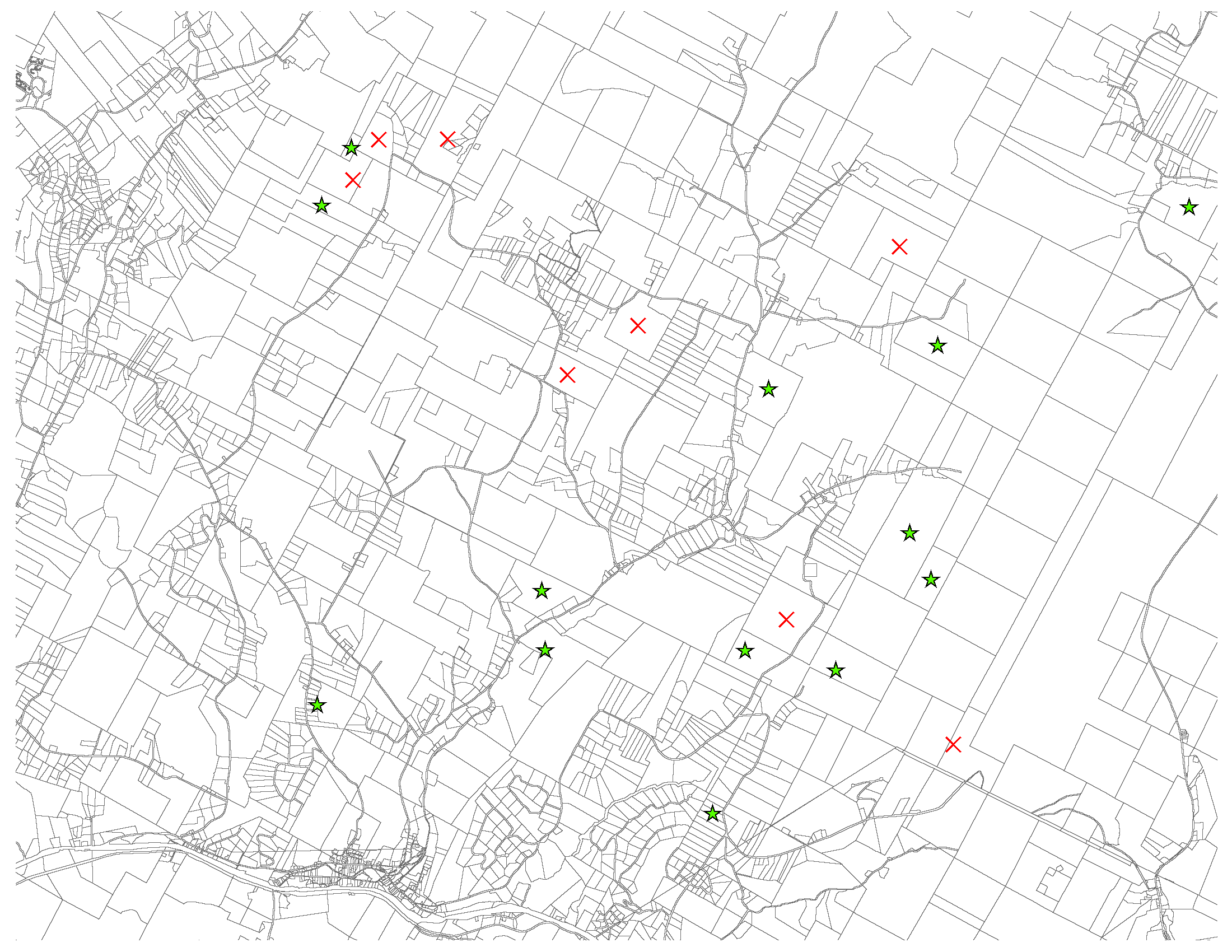
This image, highlighting Delaware County properties, shows logging jobs (green stars) where WAC funded best management practices between July 2013 – July 2015, while the red Xs show harvests – as identified with the help of Feature Analyst – where the organization has not been involved.
After extensive analysis, WAC foresters determined that the cutting of trees is currently not specifically a threat to New York’s water supply. Nearly all acres logged were Light harvests (93 percent), meaning loggers removed less than 50 percent of the canopy. Almost no logging (5 percent of harvested acres) occurred within 100 feet of a stream, and 96 percent of that logging was Light.
Forestry staff also uses Avenza (on smartphones) for field data collection and interactions with loggers and landowners. Where more detailed and precise coordinates are required Garmin GPS units are used.
Summary
As illustrated in the first image in the article, the upstate New York City Watershed geographic footprint is huge: Largely rural and covering eight New York State counties and two in Connecticut. Deploying geospatial applications focusing on best practices and the management of watershed land uses and agricultural practices provides a multitude of opportunities. However, its rural nature provides numerous challenges – most notably consistent high speed internet connectivity and wireless coverage – to support important field applications which are germane to the WAC day-to-day business functions. WAC’s geospatial activities have matured considerably over the past 3-4 years which will most certainly augment and further New York City Department of Environmental Protection’s long term efforts of protecting watershed water quality through improved land use practices.
Contact: Nadine Trahan, WAC GIS Coordinator, at ntrahan@nycwatershed.org
The author acknowledges the significant contribution of Nadine Trahan in the development of this article