Chromebooks, Google Classroom and Google Earth Together Provide a Framework for Teaching Geography and many other subjects in K-12
I actually started drafting an article on Google Earth in the classroom last fall but since then it’s been one thing or another pushing things to the back burner. Mostly work priorities but then COVID-19 sent everything sideways. Seemingly pointing us all in a new and uncharted direction. A new and greater reliance on the internet as many of us found ourselves working remotely.
The remote work force in many of our extended families includes teachers of whom I now have even greater respect after watching what is involved in teaching remotely and online. The lesson plans, prep work, surgically attached to the computer, and the seemingly endless hours of the encompassing interaction with students – and parents – well beyond the normal eight-hour work day.
In a roundabout way watching this teaching workflow unfold during the COVID lockdown brought me back to the Google Earth article. Google’s presence in the classroom is ubiquitous built around Google Classroom which I can only imagine will grow immensely as remote K-12 education expands in the future. Wrapped in with kabillons of lesson plans, templates, covering every education topic, discussion groups, forums, and blogs from around the world – everything built on top of Google technology. Easily delivered and made available to the masses at all levels of the educational spectrum with the uber cheap and incredibly functional Google Chomebook. (btw – using one as I type). And easily accessible within this framework – and bringing me back to the beginning of this article – is the Google Earth product for use in the classroom. It’s an incredible product to augment K-12 classroom teaching and not just for geography.
Over the years, the Empire State GIS community has seen a limited degree of involvement with educators in the K-12 system. It’s been my experience what apparently seems so obvious to us as GIS professionals that our technology is THE teaching tool to support education in the earth and social sciences, geography, and civics (and more) in the K-12 space, to teachers the GIS software platform is only as good as how easily it can be integrated into their mandated academic curriculum. One of the several reasons, client software never had a chance. And while Google Earth is a download, once it is running in a browser and easily accessible with the other Google Classroom products, it’s much easier for a teacher to bring geography into the lesson plans.
Also, across the state, some K-12 age mapping work is also being facilitated by non-profits as identified in a couple of earlier blog posts (Rochester GIS Scholars and efforts of the New York Geographic Alliance). Several years ago, Environmental Systems Research Institute (ESRI), the New York State GIS Association and the New York Institute of Technology (NYIT) in conjunction with the New York State Teacher Centers (NYSTC) partnered on a ArcGIS desktop license K-12 program.
Google Earth Pro Released
Google released Google Earth Pro 7.3.3 in late April which is the latest update to the Google Earth Pro desktop application. Users can download and install the new Google Earth product release as well as visit the Google Earth website “Earth Versions” page. This is a significant release which includes new enhancements, bug fixes, and security enhancements.
 Ironically, an educational YouTube video (How to Use Google Earth in 2020) was released nearly at the same time making reference to both the use and value of the Google Earth product as part of remote learning during COVID-19 stay-at-home. Another informative article “Tips for learning at home with Google Earth” was also just published by the Google Earth Education team.
From Around the State
(Note: If you have the Google Earth installed, click on the .kmz files referenced in the remainder of the article to download and view).
Even though Google’s broad “Chromebook Classroom” presence across the state appears to be quite ubiquitous, it still proved to be a challenge cracking into the Google Earth educator network – albeit respectfully knowing how busy all of our K-12 educators have been of late. I was fortunate enough to make contact with Dr. Micah Shippee who teaches in the Liverpool Central School District outside of Syracuse and is well versed with the software. In fact one of his recent projects centering on Onondaga Lake’s history, pollution, and clean up was featured in an Google online video: “Create You Own Maps and Stories in Google Earth”. Prior to the Onondaga piece in the video, there is also reference to how the American Rivers is using Google Earth on a Hudson River story map. The entire video is only about two and a half minutes, so take a look. He also provided some samples of Google Earth files (kmz) from his 7th grade social studies class. One is a simple outline of the 50 States.kmz while another is a much more involved project entitled StudentUSHistoryMap.kmz
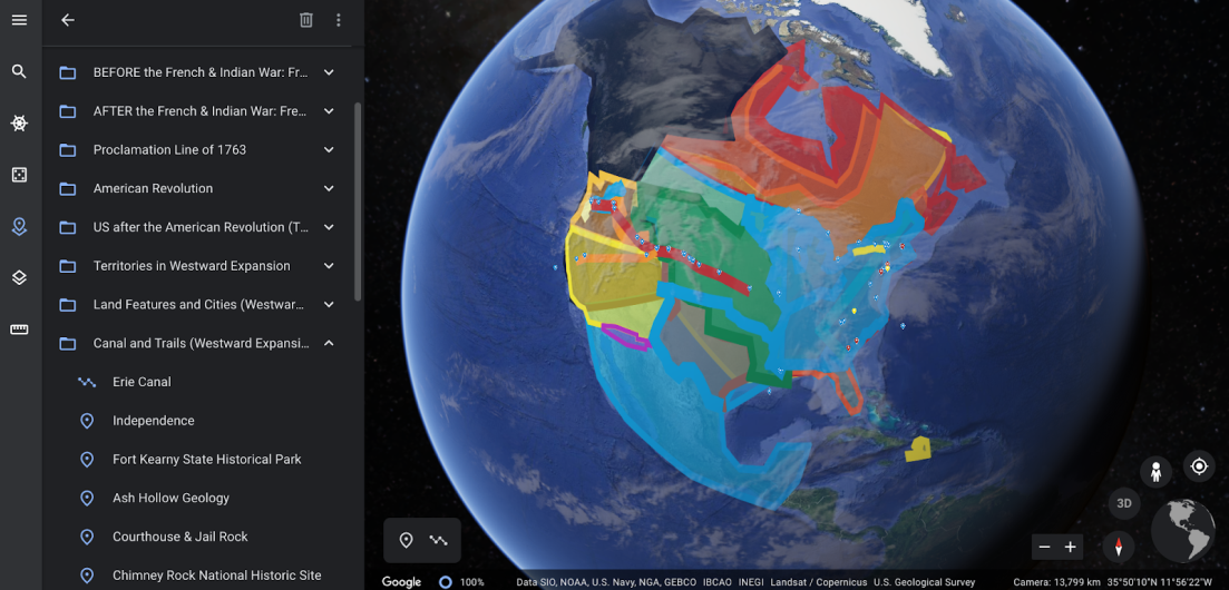
The Student U.S. History Map identifies major historical eras such as the American Revolution, Territories in the Westward Expansion, the French and Indian War, and more.
I was also able to catch up with Ms. Carol LaRow who is a teacher in the Albany area and uses both Google Maps and Google Earth for Social Studies classes. She is a Google Certified Teacher and trains teachers at all levels (elementary, middle school, and high school) in many of the Google tools. Her 7th grade social studies class uses Google Earth to augment the teaching of the scholastic American Revolution era book My Brother Sam is Dead. The entire book is book marked to specific geographic areas across New England allowing the user (or reader) to pan and zoom effortlessly. And includes a nice cartographic touch by making much of the content scale dependent. This is a great Google Earth teaching example – download MyBrotherSam.kmz.
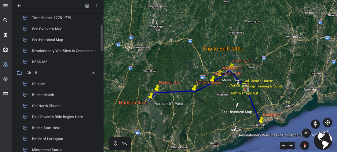
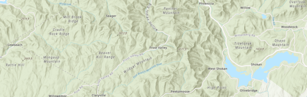
Areas of the Lower Hudson River are highlighted in the My Brother Sam is Dead book. Tying the book to mapping software makes the learning process more interactive and highlights the geographic element of the storyline.
It’s worth pointing out a couple other scholastic projects – albeit these using Google Maps – from Ms. LaRow’s extended work including the Fultonville Historical Walking Tour developed by a student from Fonda Fultonville High School and the Kingston, New York – Historic Sites project created by 4th graders at the George Washington Elementary School. Historic sites in the Kingston project are linked to YouTube video clips which includes an audio narrative of each site as read by a student. Cool stuff.
Other Google Earth projects for the classroom can be found on the New York Science Teacher website which features projects/files contributed by science teachers around the state albeit several of the projects are dated. While many of the projects go beyond the Empire State footprint this site includes the 1989 NYS Generalized Bedrock kmz file and the accompanying scanned and georeferenced hand-colored hardcopy manuscript.
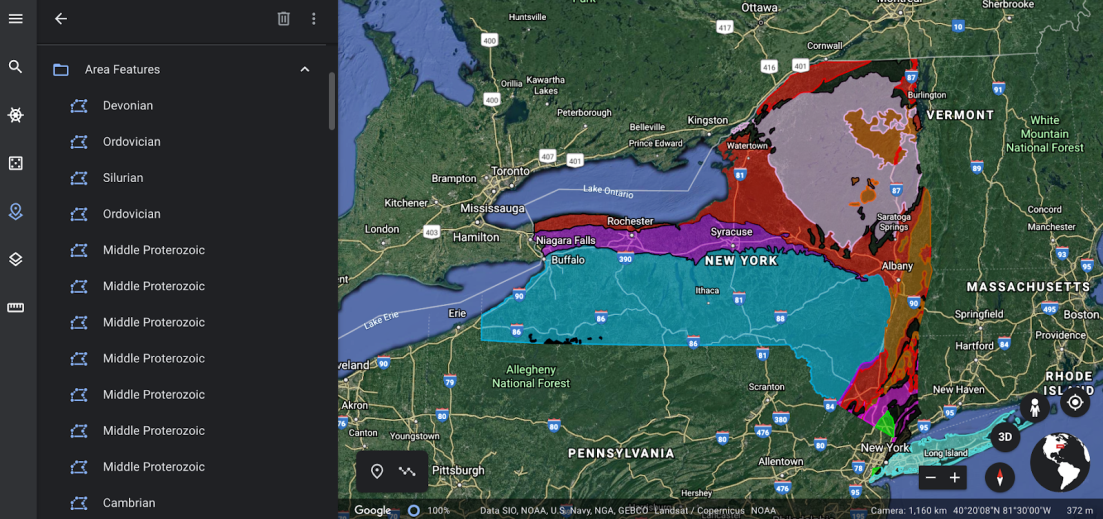
Generalized Bedrock is a commonly used GIS dataset. This version is a .kmz found on the New York Science Teacher website.
Finally, while attempting to connect with the Empire State Google Earth educational community I joined the Google Groups earth-edu-community distribution list. Just prior to publishing this article I was introduced to the New York City based United Nations Development Programme e-learning program Learning for Nature which uses Google Earth to create stories about the work of local and indigenous communities around the world which design and implement solutions for sustainable development.
Summary
Its worth taking a look at the generic Google Earth Educational Resources page or the one specific for GE entitled Teaching with the Earth. Both are pretty impressive and makes one to try and remember how the earth sciences, geography, and civics curriculums of our generation were taught? For further reading, other Google Earth examples can be found on the PBS LearningMedia website for New York Educators.
With in-person conferences probably on hiatus for the forseeable future and the virtual shows more of the norm, it may be easier to engage K-12 earth science or Google Earth educators who have often been absent – for a myriad of reasons -from the statewide GIS meetings. As it becomes more common and easier to publish our professional work products and content in generic formats there should be more opportunities to showcase and use in the Empire State Classrooms.
Across the Empire State, it’s probably a pretty good bet there are K-12 educators using the Google Earth product near you.