Empire State GIS/Mapping DIYer Phenom: Andy Arthur

Self-taught hobbyist has a treasure chest of geospatial content on website

One of the benefits of writing about all-things geospatial in Empire State is sometimes I just don’t know what I’ll come across.  Looking for this thing and finding that.   Starting in earnest on an article about a certain GIS channel and a couple days later finding myself having completely jumped the rails and find myself way over there writing about Channel Z.  (Yup, that static in the attic).  Or ending up on a cool or fun website not really knowing how I got there.

Case in point:  Interactive Maps by Andy Arthur.  Empire State mapping DIYer extraordinaire.  Just a hobby.

When I first stumbled onto the site and having spent some time driving around, I realized I needed to find out who was behind it all.  It definitely isn’t the kind and feel of the traditional geospatial website I normally include or reference in my blog, but enough interesting – and yes, quite different – content to dig a little deeper.  And glad I did.  This is not a blog post to focus on a particular topic or concept, but rather just more of a pointer to the URL and let you take away from the website what you want.  

It turns out the person behind all of this is Andy Arthur, who by day, is Deputy Director of Research Services in the NYS Assembly.   “I have no formal GIS training, as things were still pretty primitive back when I was in college (SUNY Plattsburgh)  in the early 2000s especially when it came to web services, online data and open source software” says Arthur, “computers were a lot less powerful back then. I remember vaguely hearing a bit about Remote Sensing when I was involved in the Environmental Science Club in college, but it wasn’t something I ever used.

Since then and working on his own, Arthur picked up QGIS (and the accompanying PyQGIS developer tools), as he was looking for a way to make his own topographic maps because he wasn’t happy with what was available on  the Internet. He later found out he could FOIL a primative campsite shapefile from NYS DEC and get data from there to help find campsites. “I was pretty good at map and compass stuff from my years in Boy Scouts and always interested in environmental and land use issues”, he says.  Over time, he branched out into other geospatial areas including web services.  More recently He’s been focusing on more automation of processes, using Python and R statistical language to do some map plotting and a lot of Census data gathering and processing. “I like working with R as it is fast and easy to implement code in. I’ve also lately been doing a lot more with Leaflet and web services”.  Along the way he continues to use GeoPandas and Leaflet for map making. (btw as I was putting this blog piece together I found out the creator of Leaflet 11 yeas ago was  Volodymyr Agafonkin, a Ukrainian citizen who at the time was living in Kyiv.)  Content on the site is also made available in KMZ for use in Google Earth.

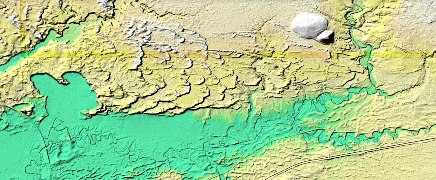
This is a example of how Arthur processed LIDAR data covering the Rome Sand Dunes west of the City of Rome in Oneida County. The landscape ifs a mosaic of sand dunes rising about 50 feet above low peat bogs which lie between the dunes. Processed LIDAR data renders the dunes very clearly. Arthur created this originally by writing a QGIS plugin that queries a shapefile with the LIDAR Digital Terrain Model Bare-Earthindex, then downloads the geotiffs, and finally joining them together to create the hillshade.The plugin itself is in Python and runs in QGIS, while the lidar download/processing script is in php-cli shell script.

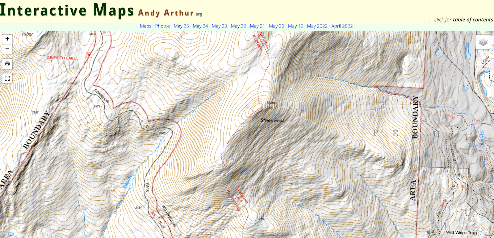
The best place to start navigating the website is to open the table of contents link located in the upper right corner of the landing page. The table of contents page then provides additional links products and visuals Andy has created including aerial photos, charts, interactive maps (recommend starting here), and thematic maps to name just a few.   This page also provides more detail on open source components, some specifics on the use of Python and Pandas, a downloadable CSV file listing of web services (WMS, ArcGIS services, etc) used on the blog, and much more.  It’s worth noting that the website also includes non-GIS/geospatial content.

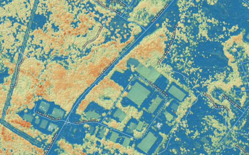
If you need some additional evidence of how much Arther has picked-up on programming, using open source components, and navigating the geospatial landscape in this space,  check out his tutorial on how to create a  Digital Surface Model GeoTIFF Using National Map Downloader, LiDAR Point Clouds and PDAL.  By example, the DSM image above is from a section of the Albany Pine Bush.  For a larger montage of the Albany Pine Bush digital surface model and samples of his code, click here for downloads.

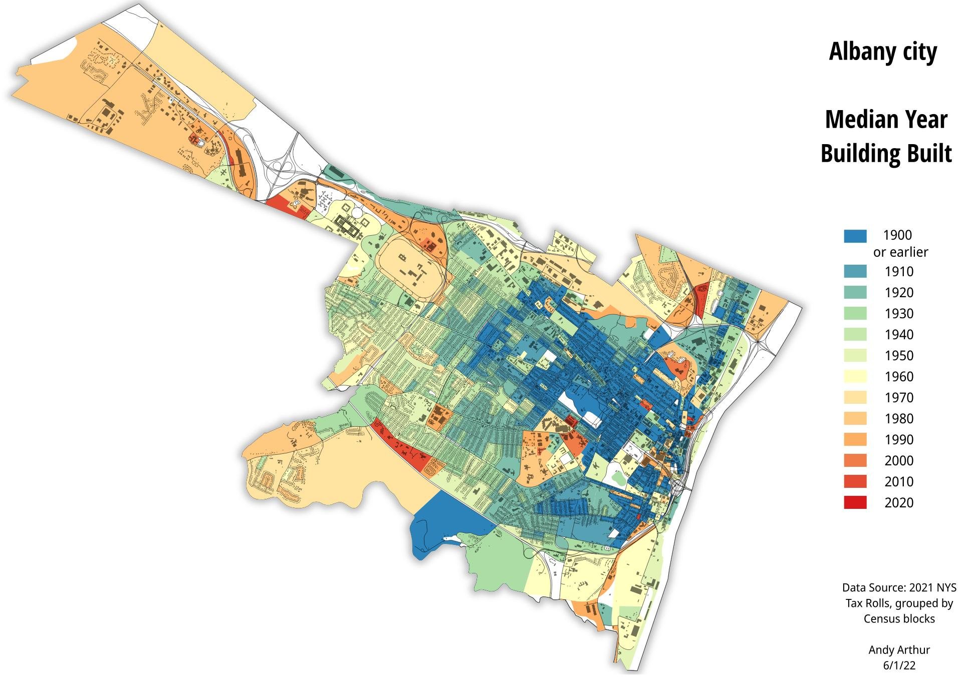
And of course, the old stand-by hardcopy product. Here, a recently created thematic map of the City of Albany median year of housing construction map. He used the NYS Tax Parcel Centroid Points data aggregated down to the parcel level using R code and created a GeoPackage. Which was then used to create the map in QGIS. Additional layers were added for context.

There are many many more examples of geospatial products, maps, and viewers on the website.  Its a great example of how much can come out of the other end when diving into and applying geospatial tools to one’s own personal interests and way of living. 

When you have a few minutes over lunch or a cup of coffee, take a look at his site.  In communicating with Andy over the course of putting this piece together, he would be open to talking with and assisting non-profit or similar community groups on specific GIS/mapping projects.  His contact information is below. 

Contact:

Andy Arthur
www.andyarthur.org
andy@andyarthur.org

Geospatial Business Spotlight: Maine Technical Source

NY Locations:     787 Old Sergeant Palmateer Way, Wappingers Falls NY
                              2634 James Street, Syracuse NY

Website:               www.mainetechnical.com 

Employees:          18

Established:         1973


The Company:

Maine Technical Source (MTS) sells, services, and supports high-end instrumentation for the geospatial industry as well as the surveying, engineering, and construction sectors throughout New England.  New York State offices are located at 787 Old Sergeant Palmateer Way in Wappingers Falls, & 2634 James Street in Syracuse. 

Gus MacDonald started the company over 45 years ago and more than half of the MTS employees have been with the company for more than fifteen years.  In June 2017, Stuart MacDonald purchased the company with a commitment to continuing the legacy of meeting customer needs.   Maine Technical Source employees are singularly focused on providing exemplary customer service.

MTS is a member of the New York State Association of Professional Land Surveyors (NYSAPLS).  

Products and Technology:

MTS provides a wide range of traditional industry products as well as state-of-the-art components now available in emerging and laser scanning technologies.  A complete listing of products can be found as part of the MTS online catalog.  

Illustrative products common to the geospatial, BIM and AEC applications include:

Field Mapping

Leica Zeno Mobile is a complete tool for high accuracy field data capture with the simplicity of an Android app.  Managing assets has never been easier via it’s intuitive user interface and functionality.  Users can export collected data to the PC as shape files, ASCII or KMZ, either in classic way via cable, USB or using the cloud with Dropbox. The app also comes pre-loaded with aerial imagery.  Learn more about Leica Zeno GIS technology via online training videos here.

UAV Solutions

MTS offers complete UAV solutions for the surveying, mapping and construction industries enabling fast and flexible data collection.  Systems capture, process and analyze millions of data points depicting highly accurate spatial information of the natural and built environment.   One of MTS’s more popular drone solutions is the DJI Phantom 4 RTK which is one the most compact and accurate low altitude mapping UAV devices. 

The Leica Aibot SX focuses on UAV data capture in the surveying geomapping, and asset  disciplines enabling users to create orthophotos, point clouds, and 3D models for cadastral survey and data collection. Leica Aibot CX focuses on UAV data capture in the construction industry providing up-to-date views over construction projects and earthmovings.  It also opens opportunities for daily progress documentation, stockpile monitoring and resource tracking to increase efficiency.

WingtraOne Gen II is a vertical take-off and landing (VTOL) sUAS for mapping of small and large areas.  It utilizes a high resolution Sony DSLR camera platform and post-processing kinematic(PPK) to provide precise geotagging of the images.  As a VTOL drone it can take off and land like a quad-copter and then transition into level flight as a fixed wing.  With the high-resolution camera it can fly missions higher and faster than a quadcopter with outstanding ground sampling distance (GSD) results.

MTS is a Pix4Dmapper reseller which is the the leading photogrammetry software for professional drone mapping.  Users can capture RGB, thermal, or multispectral images with any camera.  Pix4Dmapper’s photogrammetry algorithms transform  ground or aerial images in digital maps and 3D models. 


Field Tablets

Leica CS30 Data Collector is the best of both worlds – light weight (1.67 lbs) and compact yet with a screen size (7”) big enough for use all day long.  Equipped with an LCD IPS screen to provide an optimal color clarity, as well as a much improved and increased viewing angle. The unit also has an ambient light sensor for improved visibility in all lighting conditions.  Portable to fit into a field bag or typical pickup truck glove box.  Other similar devices MTS offers include the Carlson RT4 and the Sokkia SHC6000

Laser Scanners

MTS focuses on providing and supporting Leica Systems laser scanning technology including the new highly portable RTC360.  Intuitive and designed for maximum productivity, this unit efficiently combines the RTC360 high-performance 3D laser scanner, a Leica Cyclone FIELD 360 mobile-device app or automatically registering scans in real time, and the Leica Cyclone REGISTER 360 office software.  Depending on the specific application area of use, MTS also offers HDS software for integration into the AutoCAD, Revit, and MicroStation platforms among others.  Here is a RTC360 video

For a complete listing of all MTS products, visit their website.  

Contact:

Stuart MacDonald, President smacdonald@mainetechnical.com
Bill Treadwell, GIS Sales btreadwell@mainetechnical.com
Brad Beeler, Wappingers Falls brad.beeler@mainetechnical.com
David Filipski, Syracuse dfilipski@mainetechnical.com

Google Earth in the Classrooms

Chromebooks, Google Classroom and Google Earth Together Provide a Framework for Teaching Geography and many other subjects in K-12

I actually started drafting an article on Google Earth in the classroom last fall but since then it’s been one thing or another pushing things to the back burner.  Mostly work priorities but then COVID-19 sent everything sideways.  Seemingly pointing us all in a new and uncharted direction.  A new and greater reliance on the internet as many of us found ourselves working remotely.

The remote work force in many of our extended families includes teachers of whom I now have even greater respect after watching what is involved in teaching remotely and online.  The lesson plans, prep work, surgically attached to the computer, and the seemingly endless hours of the encompassing interaction with students – and parents – well beyond the normal eight-hour work day.

In a roundabout way watching this teaching workflow unfold during the COVID lockdown brought me back to the Google Earth article.  Google’s presence in the classroom is ubiquitous built around Google Classroom which I can only imagine will grow immensely as remote K-12 education expands in the future.  Wrapped in with kabillons of lesson plans, templates, covering every education topic, discussion groups, forums, and blogs from around the world – everything built on top of Google technology.  Easily delivered and made available to the masses at all levels of the educational spectrum with the uber cheap and incredibly functional Google Chomebook.  (btw – using one as I type).   And easily accessible within this framework – and bringing me back to the beginning of this article – is the Google Earth product for use in the classroom.  It’s an incredible product to augment K-12 classroom teaching and not just for geography.

Continue reading