
Academic Institution:
The University at Albany, SUNY
Department of Geography and Planning
Pursuing M.S. in Biodiversity, Conservation, and Policy
B.S The College at Brockport, SUNY, Environmental Science and Biology
Research Focus:
Using drones to assess white-tailed deer abundance and habitat preference in the Albany Pine Bush Preserve
Plummer’s overall research goal was to use thermal imaging drones to perform aerial surveys of white tailed deer and associated drone technology to produce an up-to-date habitat assessment of the study area to assess both white-tailed deer abundance and associated habitats. Plummer’s research proposes drones:
- Offer a faster and lower cost of aerial data capture
- Can be flown with lower detection from wildlife
- Can be equipped with thermal sensors to aid in wildlife detection
- Offer high accuracy population data with robust statistical strength
Study Area and Background:
Located northwest of Albany, the Albany Pine Bush Preserve (APBP) is approximately 3,350 acres supporting a broad variety of habitats highly fragmented by roads developed areas. Hunting, fishing and trapping are recreational activities that are carefully regulated in the preserve following relevant APBP and New York State Dept. of Environmental Conservation (NYSDEC) rules and regulations.
Historically, the monitoring of whitetail deer (WTD) has been difficult to establish due to obtaining reliable abundance estimates as traditional survey methods are normally very work intensive and/or expensive. In the past such estimates have been done within the preserve with spotlight surveys and camera trap surveys.
(Historically, obtaining reliable abundance estimates of white-tailed deer has been difficult to establish, with more traditional methods being work intensive and/or expensive, and having issues with imperfect deer detection. In the past such estimates have been done within the preserve with spotlight surveys and camera trap surveys. Plummer plans to use the findings from the previous work to help understand how the use of drones compares to the more traditional survey methods.
Unmanned Aerial Vehicles (UAV) technology, more commonly called drones, was chosen as a means to facilitate WTD data collection and analysis in the Preserve. Specifically, DJI Mavic 2 Enterprise Dual was used for the thermal deer survey while other DJI drones (Phantom 4 and Insprie 2) were used to help create the orthophoto map. A MicaSense RedEdge 3 multispectral camera which was attached to one of the drones helped pick up additional reflectance characteristics of varying vegetation types. This camera has 5 bands, with the two additional bands sensing red edge (~715 nm) and near infrared (~825nm) wavelengths.
Universal Ground Control Station (UGCS) and DJI Pilot software was used to develop flight plans over three distinct focus areas in the Preserve. Multiple flights were made to acquire enough images with sufficient overlap. Plummer used Agisoft photogrammetry software to generate orthophotos of the study areas.
ENVI software was used to generate a supervised canopy cover classification of the study area. Plummer was able to classify the entire orthophoto with >95% accuracy into herbaceous/open canopy, deciduous canopy, coniferous canopy, bare ground/no canopy, and developed canopy. ArcMap 10.6 was used in a variety of ways as well as R-Studio and Microsoft Excel for data analysis.
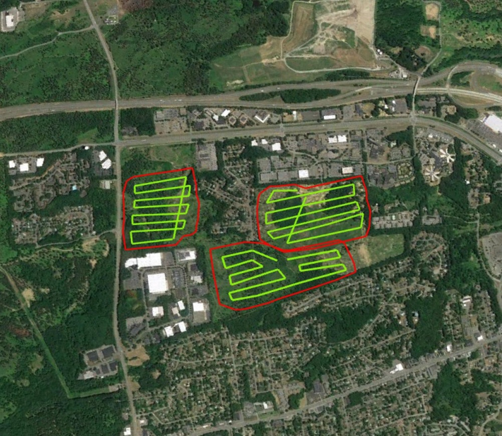
Three flight plans in Blueberry Hill East and West and the Kaikout Kill Barrens
The research team flew a total of 34 surveys between March 9th and May 22nd 2020 with all flights occurring within 1 hour of sunrise collecting over 950GB of imagery files. A total of 405 deer were spotted and identified in 143 unique locations.
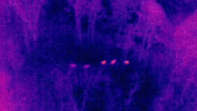
Silhouettes of five deer as seen through Plummer’s use of thermal imaging photography
Project Findings
Plummer’s initial calculated observed average density of 13 deer per sq. km is unlikely to be uniform over the entire Preserve due to varying landscape dynamics and various habitat types. The abundance within their study area varied widely over time, which Plummer suggests is explained by daily movements made by individual groups into the nearby residential areas. With regards to habitats, deer were more frequently found in the following areas of the Preserve: (1) areas of recent timber harvest, (2) Pitch Pine cover and in the pitch-pine scrub oak barrens, (3) areas with significant dune activity, and (4) close to the edge of Preserve boundaries. He believes this new method for assessing white-tailed deer abundance has high potential in the wildlife monitoring space and hopes his findings about deer within the Preserve will help generate well informed deer management decisions.
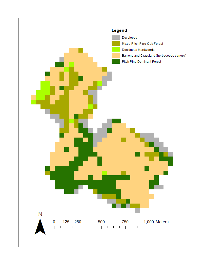
Plummer generated a habitat classification map based on the percent of each canopy type within a 50m x 50m grid covering the entire study area. The Pitch Pine Dominant Forest habitat along the southern border of the Preserve was one of the areas with the highest WTD counts.
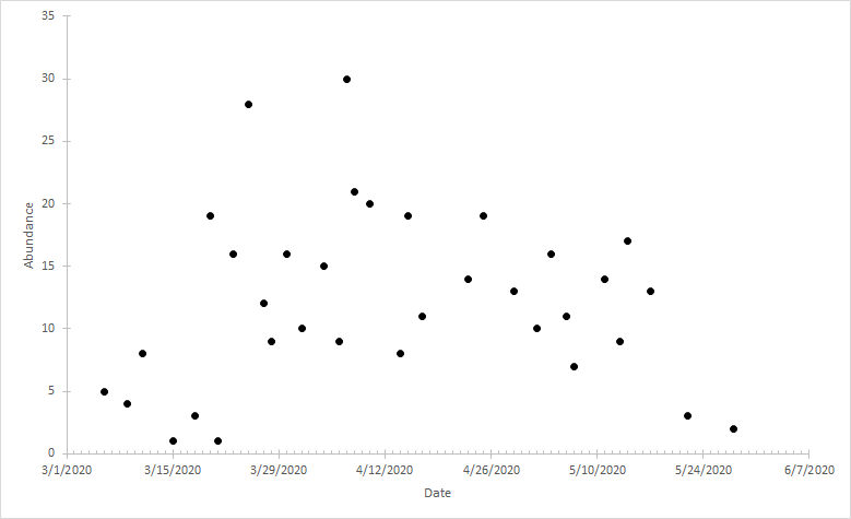
Actual WTD observed during any given survey varied over time. Over the near three month data collection period in early 2020, WTD observation counts ranged from 1 to 30
Summary
Plummer’s SUNY Albany graduate work suggests that thermal drones are a viable tool to assess WTD population dynamics and can generate reliable abundance estimates. Drone deployment provides the ability to survey large geographic areas in a small amount of time and a cost effective manner. Results show that deer use a variety of habitat types in the Preserve and numbers at any one location varies temporally. A detailed video presentation Chris made outlining his work to the members of the APBP is available here on YouTube.
Post-graduate work, Plummer would welcome the opportunity to work for an agency such as U.S. Fish & Wildlife Service or NYSDEC Division of Fish and Wildlife. He’s not opposed to going back to school for a PhD but not anything immediately. He is also very interested in public policy related to climate change and sustainability.
Contact:
Chris Plummer
Graduate Student
University of Albany
Geography and Planning
ccplummer@albany.edu
Dr. Alexander Buyantuev
Associate Professor
University at Albany
Geography and Planning
http://www.albany.edu/gp/Buyantuev.php