
Academic Institution:
SUNY College of Environmental Science and Forestry
Department of Environmental Resources Engineering
Ph.D Environmental Resource Engineering (Dec 2020)
Drexel University
Department of Civil and Environmental Engineering
B.S. & M.S. Environmental Engineering
Research Focus:
Ge’s doctoral research focused on monitoring riparian vegetation conditions overtime and quantifying correlations to selected water quality variables. In addition, he focused on quantifying the impact of riparian vegetation presence on river channel boundary changes. Such riparian vegetation environments have a significant role in filtering contamination and maintaining water quality in riverine and stream systems. His research involved the use of high spatial resolution aerial photos to detect and delineate riparian vegetation status. Riparian ecosystems across New York State remain under stress from climate change, agricultural practices and urbanization.
Study Area and Background:
Ge’s study areas included the Genesee River which originates in Gold, PA flowing north to Rochester, NY and ultimately into Lake Ontario. Land cover in the study area is dominated predominately by agriculture and forest, with smaller amounts of developed land, including a mixture of residential, commercial, transportation, and other non-developed lands. Various parts of the Genesee River are currently listed as impaired on Section 303 (d) of the Federal Clean Water Act based on the presence of various pollutants, which includes phosphorus, sedimentation, oxygen demand, and pathogens. Riparian buffers along the Genesee River play a significant role in improving the overall condition of the river and help combat many of the water quality related problems through filtering various contaminations, trapping sedimentation and ultimately improving river water quality.
The Mount Morris gravity dam on the Genesee River was utilized as a separation point when comparing the results of riparian vegetation indices. This separation formed a logical break since upstream of the dam the channel follows its natural path, whereas flow downstream of the dam is regulated by the dam instead of natural flow regimes. An interactive web map of the study area is here.

The Genesee River watershed stretches from Lake Ontario in the north to Northern Pennsylvania in the south.
Data and Software:
Data: Central to Pu’s research was the use of the Google Earth Engine (GEE) which includes two freely accessible image programs: (1) United States Department of Agriculture National Agriculture Imagery Program (NAIP) imagery, and (2) Landsat products. The NAIP images are airborne color-infrared orthorectified images acquired at 1 meter ground sampling distance. This fine spatial resolution enables interpolation of detailed information on the boundaries of river channels and riparian vegetation. The NAIP program collects imagery on a regular basis, with images of the study area available from 2003–2015. GEE provides access to Landsat 5 and 8 8-day Normalized Difference Vegetation Index (NDVI) and Enhanced Vegetation Index (EVI) composites.
Other geospatial datasets also utilized included USGS water quality data, and (2) National Oceanic and Atmospheric Administration (NOAA) weather data. Downstream water quality data was collected by the USGS in the Genesee River at the Ford Street Bridge in Rochester, NY and downloaded through the USGS Water Data for the Nation. Parameters collected include water temperature, specific conductivity, pH, turbidity and dissolved oxygen. Daily weather data is collected by the National Oceanic and Atmospheric Administration (NOAA) at three airports within the watershed: Greater Rochester International Airport, Cattaraugus County Olean Airport, and Dansville Municipal Airport. Weather parameters recorded include daily mean precipitation and daily cumulative air temperature. Weather parameters across the three stations were averaged to eliminate micro climate effects. Water flow/gauge data provided by the U.S. Army Corps of Engineers.
Software: Data was examined and processed in a variety of desktop software packages and cloud platform including, as previously identified, Google Earth Engine as well as ArcMap, QGIS and R.
Project Findings:
This project developed a new method to extract multi-temporal riparian vegetation indices directly from satellite image composites which included five major steps: (1) Identifying the channel boundary, (2) creating a buffer around the channel, (3) classifying land cover within the riparian buffer, (4) converting pixel-based vegetation buffers to polygons, and (5) generating final riparian buffer boundaries.
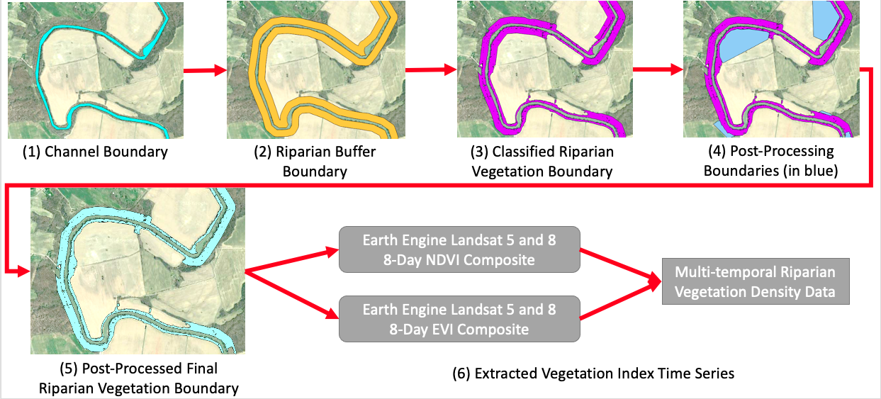
Pu’s Genesee River riparian mapping was based on GEE’s multi-petabyte catalog of satellite imagery and geospatial datasets which are available for scientists, researchers, and developers to detect changes, map trends, and quantify differences on the Earth’s surface.
The project utilized GEE for both image processing and spatial analysis processes, along with some usage of QGIS. GEE was found to provide an efficient means to perform environmental data monitoring because it eliminates the processing time and effort involved with downloading, sorting, and combining datasets in order to perform the calculations and other processes necessary to obtain time series vegetation index data calculations.
Findings indicate that downstream water temperature and dissolved oxygen have moderate to strong correlation to riparian vegetation index (magnitude of Spearman’s correlation coefficient generally above 0.5), while other water quality parameters do not. Water temperature was positively correlated with the vegetation index values, while dissolved oxygen was negatively correlated. There were no significant differences in terms of correlation between the two sections of the river.
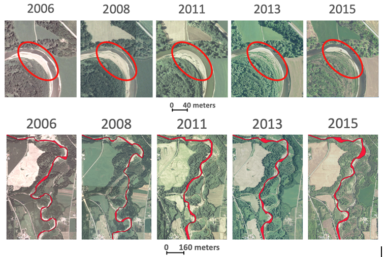
Analyzing nearly a decade of imagery covering the Genesee River footprint, Pu’s research shows the meandering of both the main river channel and at major river bends both of which impact adjacent riparian habitats.
Overall, the study developed a new method to rapidly extract time series of riparian vegetation indices directly from satellite image composites. In delineating the main channel of the Genesee River and mapping riparian vegetation within 90 meters of the channel the research observed the expected annual trends, where the index rises in the summer season while falling in the winter season.
Findings will be useful to riparian stakeholders and managers to conduct informed riparian vegetation management and restoration. Delineating riparian vegetation extent from higher resolution imagery allows one to identify riparian zones that have significant riparian removal or channel variations and to prioritize restoration sites considering both spatial and temporal scales. Results drawn from Pu’s research has been and will continue to be presented at local and international conferences for improving current riparian management approaches.
A more complete and detailed document on Pu’s research containing further discussion/analysis, statistics and graphs, and summary details can be downloaded here.
Google Earth Engine (GEE):
Jeff’s extensive use of GEE as part of this doctoral work led to additional work which was primarily funded through AmericaView and SUNY-ESF. Funded primarily through a grant from the U.S. Geological Survey, Ameriview is a consortium comprised of university-led, state-based consortia working together to sustain a network of state and local remote sensing scientists, educators, analysts, and technicians. The state’s AmericanView affiliate is New York View (NYView) which is administered through the Department of Environmental Resources Engineering (ERE) at SUNY-ESF. The NYView academic consortium includes the State University of New York (SUNY) College of Environmental Science and Forestry (ESF), the Institute for Resource Information Sciences (IRIS) at Cornell University, SUNY Fredonia, and SUNY Plattsburgh.
Through this NYView project, Jeff developed a series of 16 free-to-access Google Earth Engine online training videos (available on YouTube) for the beginner to advanced which demonstrate applications to support teaching, research, and outreach in remote sensing and image processing. GEE is a cloud-based platform that combines a catalog of satellite imagery and geospatial datasets with planetary-scale analysis capabilities. This platform is available for academic, non-profit, business, and government users to analyze and visualize the Earth’s surface. He was able to also work closely with the Google Earth Engine development team which provided access for development and programming assistance. A one-page summary of the NYView 2019-2020 Mini-Grant project can be downloaded here.
Summary:
Jeff is currently preparing for a postdoctoral research position. He hopes to become a professor in the future based on his of research and associated work in academia. His research interests continue to evolve in the realm of water resource engineering with a focus of utilizing the latest technologies to help solve water resource challenges across both urban and rural environments.
Contact:
Ge (Jeff) Pu
State University of New York – College of Environmental Research and Forestry
Department of Environmental Resource Engineering
gpu100@syr.edu
Dr. Lindi Quackenbush
Associate Professor
State University of New York – College of Environmental Research and Forestry
Department of Environmental Resource Engineering
ljquack@esf.edu