
PhD Candidate/Geography June 2025 (Anticipated)
Department of Geography
University at Buffalo Buffalo, NY
M.S. Epidemiology May 2020
School of Public Health
Department of Epidemiology and Biostatistics
University of Albany Albany, NY
B.S. Biological Sciences May 2018
Department of Biological Sciences
University at Albany Albany, NY
Research Focus
O’Connor’s doctoral research focuses on the spatial ecology and epidemiology of tick borne diseases in New York State. In particular, his dissertation work examines two genetic variants of Anaplasma phagocytophilum, the pathogen that causes anaplasmosis. Anaplasmosis is the second most frequent tick borne disease in New York State behind Lyme disease. An August 2021 article in Medscape reported Anaplasma cases nearly quadrupled statewide from 2010 to 2018. On a larger scale, Anaplasmosis became a nationally notifiable disease in the United States during 1999 after nationwide case counts increased significantly. Most of these infections occur in the upper midwestern and northeastern states, with eastern New York and the Hudson River Valley areas being of particular focus and concentration.
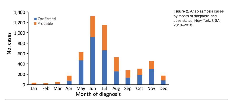
It comes as no surprise that confirmed Anaplasmosis are the highest during the summer months when people are active in the outdoors.
Background
O’Connor started his research on anaplasmosis while working on his masters degree at UAlbany with a team of other public health researchers and scientists in both academia and government. Their ongoing and collective research focuses on evaluating human risk of acquiring anaplasmosis (as well as Lyme Disease, babesiosis and other tickborne diseases) at publically accessible lands, based on measures of tick density and pathogen prevalence. Central to the investigation is looking at the relationships between human activity and environmental characteristics of specific land cover types supporting mammalian populations which serve as both transmitters and hosts of the A. phagocytophilum pathogen.
O’Connor’s research involves numerous datasets as part of his research, most notably human case data – which is analyzed at the ZIP Code Tabulation Area (ZCTA) level – as reported to the New York State Department of Health (NYSDOH). Data is aggregated by NYS regions (Capital, Central, Metro, and Western) and ZCTA by using patient address and 2010 US Census population data and shapefiles.
Data and Software
Field data on host-seeking ticks is collected from publicly accessible lands across NYS using standardized drag surveys. Collection sites are selected on the basis of tick habitat suitability and risk for human exposure (e.g., presence of leaf litter and hiking trails). Tick habitat suitability is selected based on land cover types, typically northern hardwood forest where habitat is suitable for white-tailed deer, various species of mice and other small mammals. Most sites were located on state or county-owned land such as wildlife management areas and parks. The program has one – three sites in each county which are visited (typically) twice a year. Other geospatial-related variables which have been found to have statistically relevant association with the spread of A. phagocytophilum include elevation and weather/climate (temperature and precipitation).
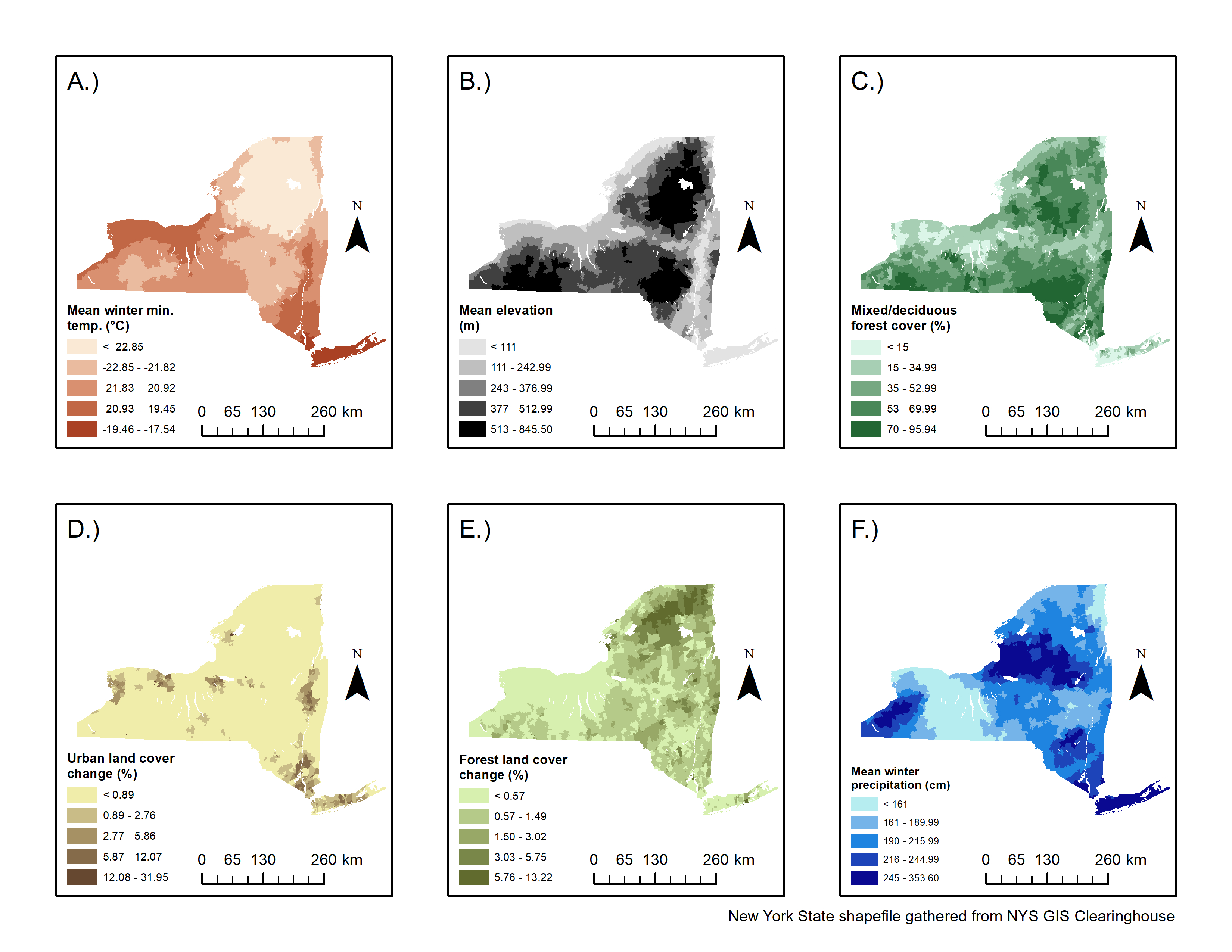
Environmental covariates with statistically significant associations to either human granulocytic anaplasmosis or human babesiosis.
While O’Connor used ESRI software during his graduate work, he now utilizes R / RStudio for most graphing and mapping products. His research software toolkit also includes SAS (Version 9.2) and statistical analyses includes Getis-Ord Gi* hot spot analysis which is integrated with ArcGIS Pro. The entomologic risk index (ERI) is used to estimate the human risk potential for becoming infected with a pathogen according to tick density and pathogen infection prevalence within tick populations.
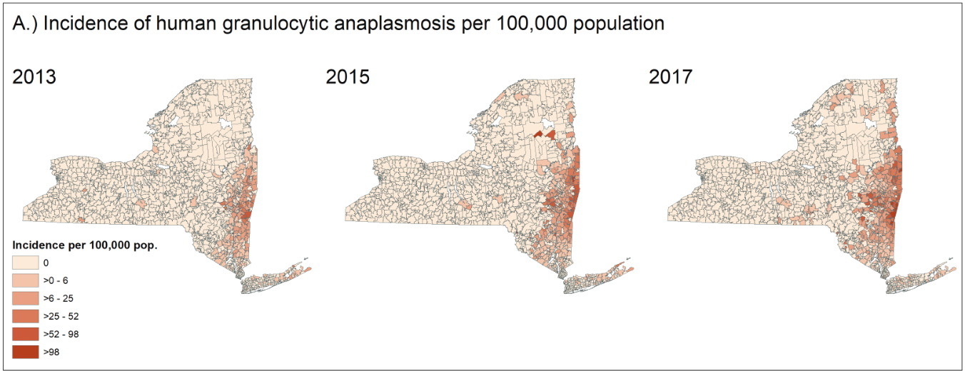
O’Connor’’s research has demonstrated that the incidence of anaplasmosis in New York has increased in spatial scope and magnitude.
Summary
O’Connor’s research in this area is detailed in much greater detail in these peer reviewed professional articles: A Comparative Spatial and Climate Analysis of Human Granulocytic Anaplasmosis and Human Babesiosis in New York State (2013–2018) and Epidemiology and Spatial Emergence of Anaplasmosis, New York, USA, 2010‒2018. He and his colleagues just published a new article describing the genetic variants of Anaplasma phagocytophilum through the Centers for Diseases Control and Prevention which includes several updated maps and graphics.
Many potential driving forces, including changes in land use, host density, and climate, have been implicated in the geographic spread of ticks and associated pathogens and it is probable that a multitude of factors are shaping the spread of anaplasmosis in NYS. O’Connor states:
“The goal of my research is to explore how mammalian movement patterns potentially influence the spread of blacklegged tick populations, as well as the pathogens that are carried by the ticks and mammals. One of the aims of my project is to develop a spatially-explicit agent-based model that incorporates feedback between the spatial scales that each mammal moves at, specifically, deer moving across landscapes and mice moving within local forest patches.”
Contact:
Collin O’Connor
Graduate Student (PhD)
Department of Geography
University of Buffalo
collinoc@buffalo.edu