
Cattaraugus County and Allegany State Park Share Resources and Vision
While GIS as a shared service as part of Governor Cuomo’s County-Wide Shared Services Initiative (CWSSI) has yet to take hold in a broad context across local governments in the Empire State, the statewide GIS community does have a great example to highlight how local governments can collaborate with a state agency in sharing geospatial technology. Case in point: The Allegany State Park Interactive Map viewer.
Located in Cattaraugus County in western New York abutting the Pennsylvania state line and north of the Allegheny National Forest, Allegany State Park was created in 1921 and encompasses nearly 64,800 acres. A major western New York State tourist attraction – the park averages 1.5 million annually – the park offers a wide range of four-reason recreation activities and lies within the Alleghany Highlands Forests ecoregion. The idea of a joint effort between Cattaraugus County and Allegany State Park online map viewer idea goes back as far as 2010 as part of a discussion between Daniel T. Martonis, who at the time was GIS Manager for the County and Tom Livak who was then Director of Economic Development, Planning & Tourism.
The initial viewer was more emergency services focused with the collection of infrastructure data and intended for use by park staff only – nothing external. Most of the data was collected by Dan and Tom, including Chris Holewinski – the current Cattaraugus GIS Manager – using various Trimble GPS units as well as utilizing old engineering maps. The trio even brought out metal detectors to pick up the locations of pipes. At the time, Dan was building web mapping applications with ArcIMS that Dan mentions was not “people friendly” and was ultimately discontinued by ESRI. Along the way, though, both Dan and Tom knew they were beginning to frame a web mapping product which would be of great value to both the County and ASP. ArcGIS Online began to emerge as a more functional and adaptable web mapping platform providing additional opportunities for the two government programs to build upon what had been started.
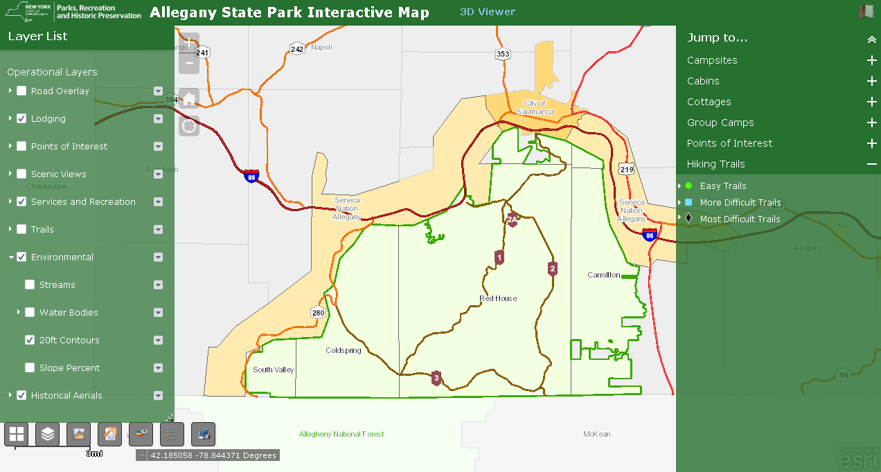
The ASP viewer represents the ongoing collaboration between Cattaraugus County and Allegany State Park. It provides easy to use access to a facility, environmental, and cultural data including historic aerial photography.
Now Recreation Focused
In 2011, Daniel was appointed Director of the Cattaraugus County Office of Real Property and during the same time period Tom Livak left county government and was appointed Assistant Regional Director, New York State Office of Parks, Recreation, and Historic Preservation, Allegany Region. And concurrently during the same time period there was a gradual shift in the focus of the viewer from emergency services to recreation and tourism.
Today the viewer includes the locations of campsites, cabins, group camps, points of interest (including historical locations), visitor services and recreational fields, scenic views, environmental data and historic aerial photography. GPS and Survey 123 has been used extensively to collect many datasets including trails and elevation to help build out the butterfly and sensory trail. A discussed future project in the park would be to GPS all the old oil, gas, and timber railroad lines that use to run all through the park. Some of the existing trails in the part today are in fact old rail beds. Most map feature locations include an attached photo and by clicking on camping feature icons (campsites, cabins, cottages, and group camps) a pop-up box appears providing a link to Reserve America where camping site reservations can be made. One stop shopping for the park visitor.
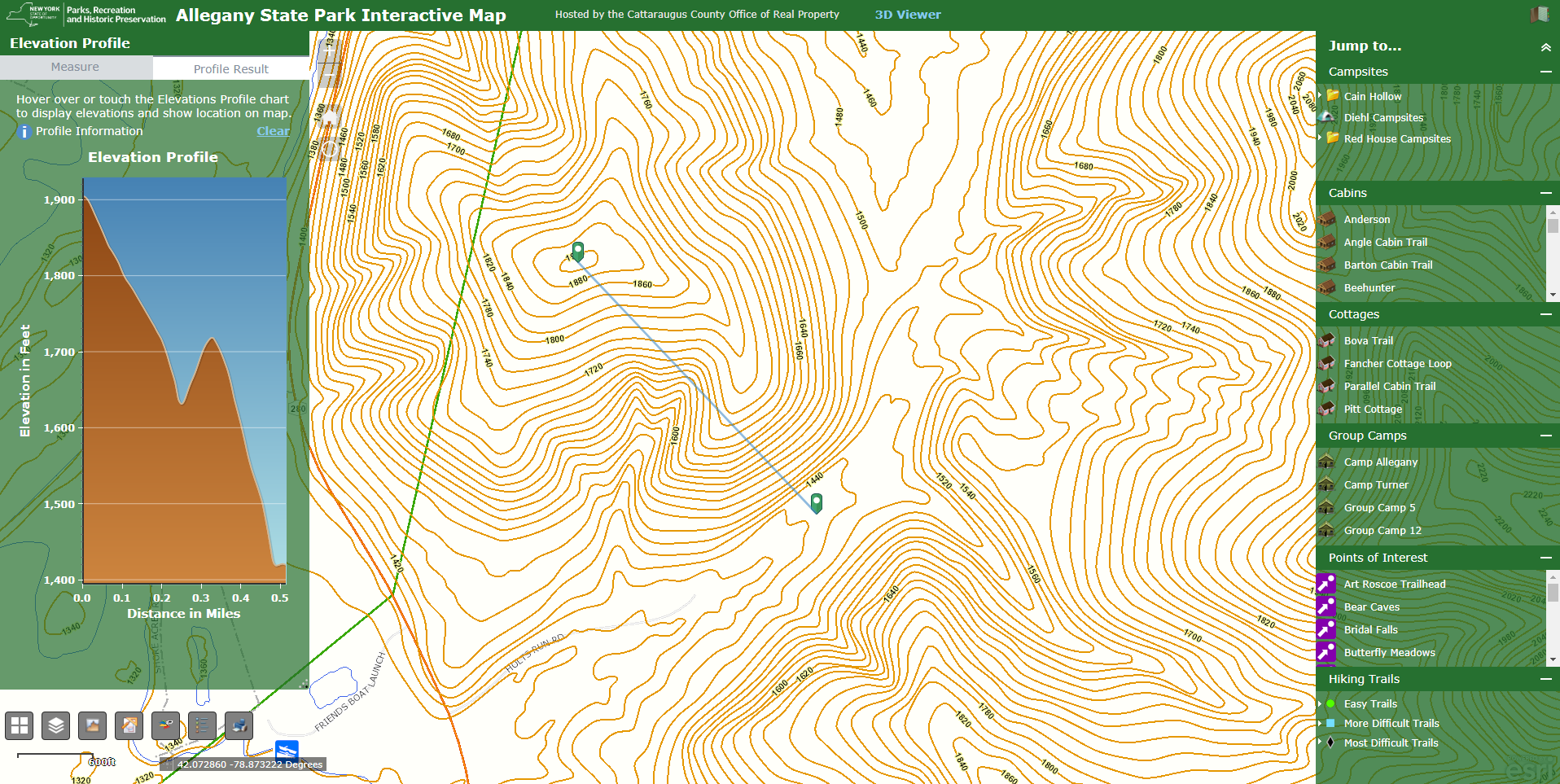
A cool widget built into the ASP viewer is the Web AppBuilder Elevation Profile Widget. Using park wide 20’ contour data, users can generate profiles of hiking trails over a defined distance. The viewer also offers access to Pictometry/Eagleview oblique imagery and a 3D Viewer which was built with the Java Script based Web Aappbuilder for ArcGIS
While not directly built into the viewer, Cattaraugus County GIS also assisted ASP with creating trailhead maps for all the trails in the park. The hardcopy maps are in kiosks at the trailheads and include elevation profiles, pictures along the trail, and a QCR bar code. Scanning the bar code with a smart phone or tablet launches an associated trail viewer so hikers can follow themselves along the trail as they walk, viewing the pictures on their phone, seeing what was up ahead like points of interest. And wow, check out the 2018-2019 ASP Visitor Map prepared by Cattaraugus County. Quite a piece of cartography.
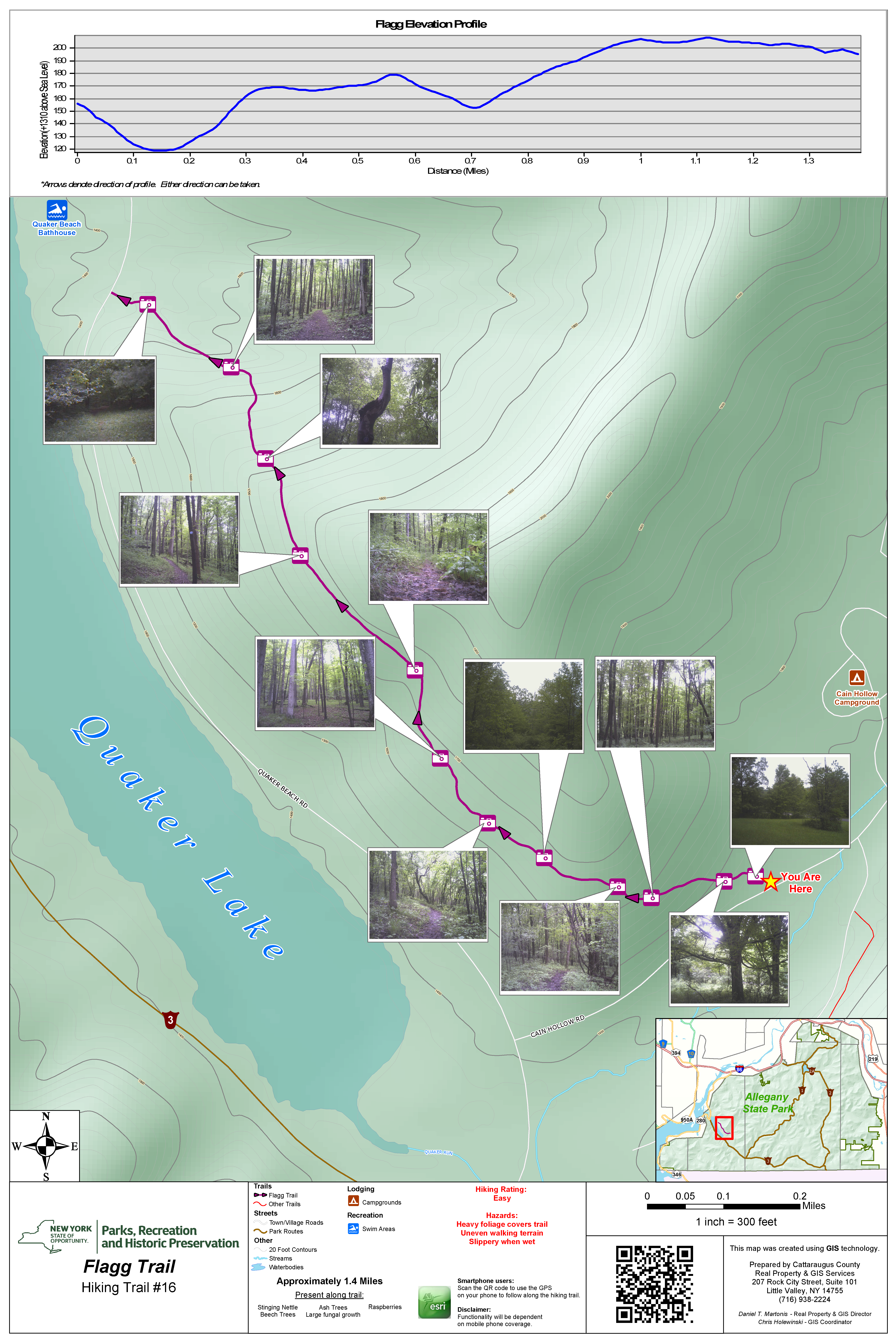
Hikers can access individual online trail maps by scanning the QCR bar code found on display maps at trailhead kiosks. This bar code launches the Flagg Trail map on the hiker’s phone or tablet.
Everybody Wins
“The collaboration between ASP and Cattaraugus County has been a fruitful one for both entities”, comments Martonis, “additionally all of the original data we collected is centrally stored in our enterprise GIS database, helping locate and solidify park infrastructure and assisting the County e911 system and EMS so that emergency vehicles can get routed to the correct cabin (named and numbered), tent sites, point-of-interest and other recreation facilities”. As tourism is a major industry in Cattaraugus County and since Allegany State Park is one of the largest tourism attractions in the County, both men feel it is natural partnership in terms of collaborating and promotion the park. It’s worth noting that to date all expenses have been shared between the two agencies in developing and sustaining the online viewer.
Even today in his capacity of Director of Real Property, Martonis recognizes the fact that many agencies and governments across the Empire State want to build GIS applications though lack the expertise and capacity to do so. He adds “We have the personnel at the County level, so why not help out entities within the County as much as we can. The ASP viewer is just one example, albeit a large one, of the many projects that we have completed with outside agencies across Cattaraugus County” .
According to Christina Croll, GIS Manager, NYS Office of Parks, Recreation, and Historic Preservation in Albany in Albany, there are other similar state park and local government GIS working relationships across the state. To name a few, she notes the State has provided trail data to both Onondaga and Tompkins Counties for integration into their E911 systems and Livingston County partnered directly with Letchworth State Park to produce the Letchworth Park Map. (btw – another nice piece of cartography)!
In the end, the ASP Interactive Viewer is a great example of a cost effective New York local-state government geospatial collaborative program. Kudos to both agencies for making the process work and the State’s similar outreach efforts in this regard. No doubt, similar geospatial opportunities certainly exist across the Empire State in a wide range of government program areas.
I asked Daniel if the County or ASP had ever presented their work at any state or regional GIS events and the answer was actually “no”. Since shared services is the buzz word now, it might be time for these guys to hit the road.
Contact:
Daniel E. Martonis
Director of Real Property Tax Services
Chairman, Cattaraugus County Land Bank
Cattaraugus County Office of Real Property
dtmartonis@cattco.org
(716) 938-2324
Thomas Livak
Assistant Regional Director
Allegany Region
Thomas.Livak@parks.ny.gov
(716) 354-6515
Chris Holewinski
GIS Coordinator
Cattaraugus County Office of Real Property
cdholewinski@cattco.org
(716) 938-2322