Geospatial Business Spotlight: Mohawk Valley GIS

Company Name:                Mohawk Valley GIS

Website:                               www.mohawkvalleygis.com

Established:                          2003

THE COMPANY

Linda Rockwood founded Mohawk Valley GIS in 2003, after her family relocated to Herkimer County, New York.   Previously, she owned North Country Technology Integration in New Hampshire, working primarily with school teachers to integrate technology and particularly GPS and GIS into the K-12 curriculum.

Initially, Linda had planned to continue offering the same type of services in New York, but found more opportunities early on providing GIS system development, data creation and training to municipalities, and designing custom print maps for organizations.

Mohawk Valley GIS moved to historic Bagg’s Square in downtown Utica in 2014 and has grown to include three full-time staff in addition to Linda, who continues to keep her GIS skills current along with coordinating all business development associated with the firm.    Interns from nearby SUNY Polytechnic Institute  and Syracuse University help when everyone starts bouncing off the walls.  The business received NY Women Business Enterprise (WBE) certification in 2013.

PRODUCTS AND SERVICES

The company has expanded to offer a complete suite of technology services including custom interactive online maps and mobile applications to help promote tourism and recreation, as well as to helping businesses, organizations and local governments towards updating websites to be mobile responsive.

By example, GoCaz.com is an interactive web map promoting four season recreation opportunities throughout the Cazenovia area in the Finger Lakes Region.  This particular project is an example of an adaptive, rather than a responsive, mobile application.  The software checks to see what device is accessing the map, then adapts by “offering” the correct version, either large screen or small device screen, as shown below.
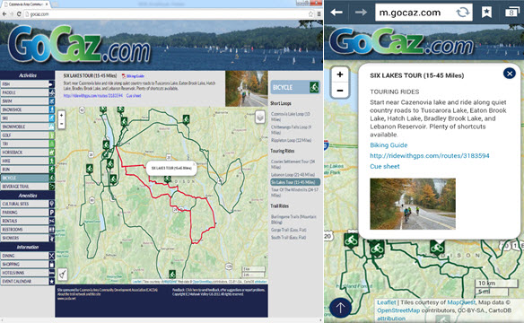
The GoCaz website is device independent - enabling users to access the application from different platforms.

The GoCaz website is device independent – enabling users to access the application from different platforms. The browser version screen is on the left and smartphone version on the right.

Mohawk Valley GIS has also been running two promotional, recreation e-commerce sites for the past six years: the winter-oriented NY Snowmobile Trails  and the summer-oriented ADK Trail Map.   The Snowmobile Map application features an interactive map with a route planner, no-reception-needed trail apps with turn-by-turn navigation, and GPS map offerings including Garmin .img file format overlay maps and regional .GPX track files and waypoints.  The application was built in partnership with over 100 snowmobile clubs throughout New York State and was just awarded a NYS GIS Association Applications Award at NYGeoCon 2015.  Many similar functions are available in the ADK Trail Map.  Both projects feature responsive interactive maps, which respond to the device screen size by repositioning elements or eliminating some functionality.
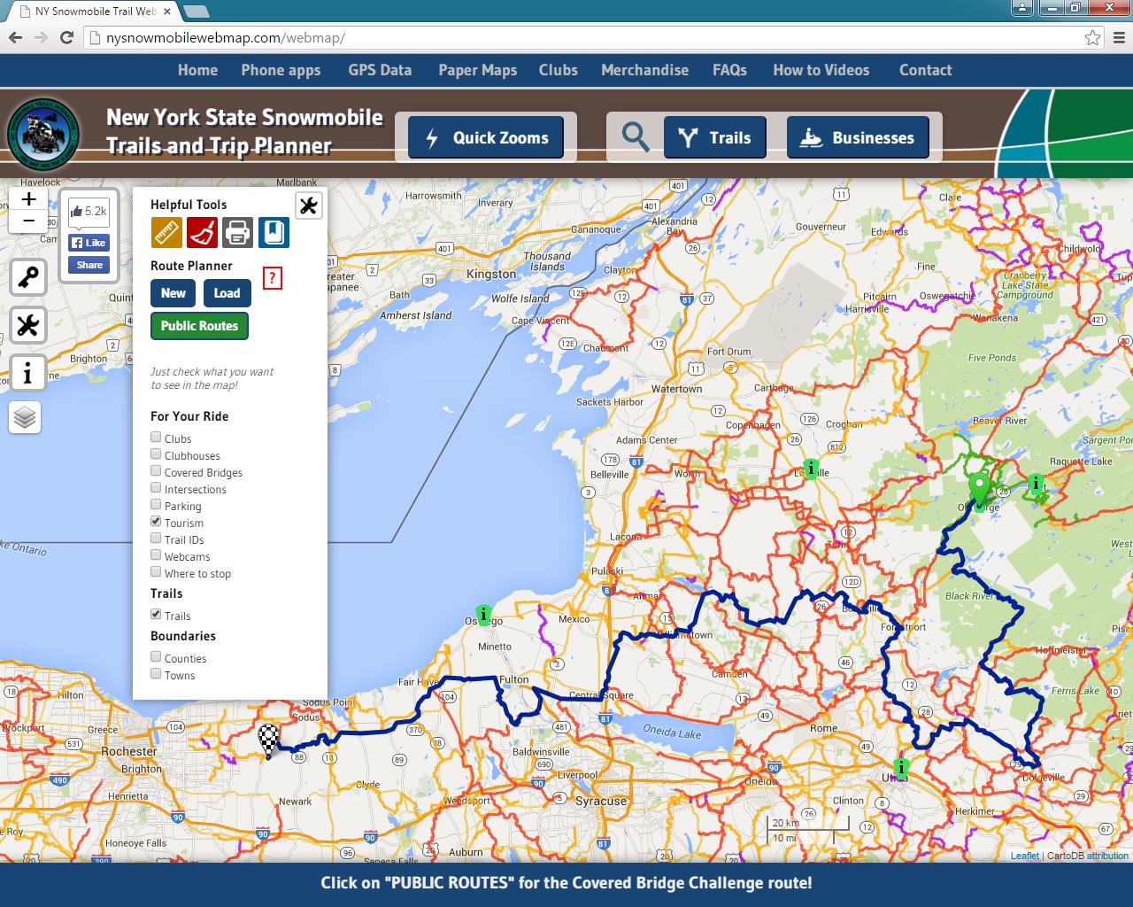
n addition to a massive catalog of snowmobile trails, the application provides access to information on lodging, restaurants, and related travel services

In addition to containing a massive catalog of statewide snowmobile trails, the application also provides access to information on lodging, restaurants, and related travel services.

The route planner and turn-by-turn navigation functionality are built using a pathfinding algorithm which required converting the shapefile representation of the trails to a graph data structure. All geospatial application code in the web map is programmed using Leaflet, an Open Source javascript library.

Core Mohawk Valley GIS services  include GPS data collection, geocoding and digitizing, custom map creation, GIS implementation and training, and GIS data analysis, particularly with regard to big data analysis for predictive analytics and visualization.

Other recent or currently underway Mohawk Valley GIS projects include:

  • Municipality mobile app for Town of Webb/Old Forge, reception required, runs on all mobile devices/browsers, designed primarily for codes enforcement department
  • Municipality mobile app for Warren County, no reception needed, for first responders, focusing on building and structure characteristics
  • Custom paper map design for Vermont Association of Snow Travelers
  • Responsive website for the Herkimer County Chamber of Commerce
  • A unique (at clients request) website, American Electrical Enterprises, which uses a high tech data and chart visualization library
  • Three “big data analysis projects”, all under Non-Disclosure Agreements (NDA), which include  strong geospatial components related to predictive analytics, marketing, and real time data interpretation

To find out more about Mohawk Valley GIS geospatial services and products, visit their website.

CONTACT

Linda Rockwood, Owner

linda@mohawkvalleygis.com

114 Genesee Street, 3rd floor

Utica, NY  13502

315-624-9545

www.mohawkvalleygis.com


10 (Almost) Questions: Todd Fabozzi

Todd Fabozzi is an urbanist, writer, teacher and drummer. During his twenty-two-year career as a regional planner he has been an advocate for cities and sustainable design. He has lectured extensively on suburban sprawl and its consequences and has been involved in numerous urban planning, climate action planning, and watershed protection studies. Todd is an expert on the use of Geographic Information Systems and has taught a course on GIS at UAlbany for the past thirteen years. Todd has also published two books of poems and anti-poems. He lives in the city of Saratoga Springs, NY.

I caught up with Todd at NYGeoCon for a short discussion on life and GIS….

eSpatiallynewyork:  How long have you been with the Capital District Regional Planning Commission (CDRPC)?

Todd:  I’ve been a professional urbanist for the past twenty-two years, twenty of which have been with CDRPC.

eSpatiallynewyork:  What’s one of the best examples of how GIS is used in your organization?

Todd:  I was charged with building the Commission’s GIS back in 1996. One of the first products from that effort was a regional atlas, which we published in oversized hard copy format (this was still pretty much pre-internet). The maps portrayed a whole variety of characteristics at the regional scale, giving the public a bird’s eye view of the spatial patterns of the Capital District for the first time. In addition to applying GIS in most of our program areas, I continue to create, update and publish regional maps (see www.cdrpc.org). I think understanding regional demographic, environmental and land use patterns is central to regional planning and GIS is the best tool for doing so.

eSpatiallynewyork: What professional associations or groups are you affiliated with?

Todd: Over the years I’ve tried out the American Planning Association, the Association of American Geographers, Progressive Planners Network, Congress for New Urbanism, and the NYS GIS Association. I also served for nine years on the NYS GeoSpatial Advisory Council. While for the most part I support the work of these groups, I’m currently unaffiliated (though with CNU and NYSGISA, it’s simply because I haven’t gotten around to renewing). I have to say though that in general I’m not a joiner, perhaps the anarchist in me keeps me at arm’s length from groups and group think.

eSpatiallynewyork:  If you had an extra $50K in your budget, what would you do with it?

Todd:  If it was a yearly allocation I would establish two part-time paid internship positions. CDRPC has been working on a climate and energy issues over the past few years and there are some interesting ways that GIS can be applied. So for example, a good intern project might be to identify (by analyzing the utility zones, solar orientation, area requirements, land uses and zoning laws) the places where community distributed solar might be feasible (community distributed solar allows one to receive solar energy from an offsite location).

eSpatiallynewyork:  Biggest professional accomplishment?

Todd:  Using GIS, imagery analysis and photography to document and portray sprawl and urban decline in the Capital District and through over two hundred presentations inciting a regional conversation on these issues back when it was politically and professionally risky to do so. This was the same presentation I made at the first NYS GeoSpatial Summit in 2006. http://www.nysgis.net/nygeosummit/year/2006/speakers.htm

eSpatiallynewyork:  What do you think of GISP certification?

Todd:  I don’t. I’m not concerned with merit badges. I’d rather let mapping do the talking.

eSpatiallynewyork:  Open Source or ESRI?

Todd:  We’re an ESRI shop but I’m open to whatever works best in a given situation…and the lower the cost the better.

eSpatiallynewyork:   If you could change one thing here in New York that you feel would make GIS more widely used, or more appreciated and understood – what would that be?

Todd:  Start teaching kids how to use GIS as part of the middle and high school curriculum.

eSpatiallynewyork:  What advice would you give to the next generation of individuals starting a career in GIS here in New York State?

Todd:  I’ve been teaching an Intro to GIS course at UAlbany for the past thirteen years and I think I counted seven different people at the most recent NYGeoCon that had taken my course and were now working professionally in NYS using GIS, which is satisfying. I reinforce to my students that GIS is a tool for something else, so get knowledgeable about something else, and then use GIS to help.

eSpatiallynewyork:  Any thoughts on the future of government GIS in the State of New York?

Todd:  There’s not much that state and local governments do that doesn’t have a spatial component, so the more we integrate GIS into government operations the more efficient those operations will be. I’ve heard you sing the gospel of web services for data delivery and I get that and think that is largely the direction things will head. Web-accessible GIS for basic tasks will also continue to proliferate, though there will still be a role for the desktop user with the full suite of tools at their disposal. I saw a presentation at the recent NYGeoCon about the City of Rochester’s various GIS applications that I found quite inspiring and think they’re setting an example of how GIS can be used in local government.

eSpatiallynewyork:  What would you be doing if you weren’t working with CDRPC?

Todd:  Assuming I was retired and didn’t have to earn a living I’d be playing my drums, writing, and traveling.

eSpatiallynewyork:  Your band is in the studio working on its 11th album – what can you tell us about it? 

Todd: Well, as some of my planning and GIS colleagues know, I’m also a professional drummer, and over the past eighteen years I’ve been the conga player for a twelve-piece original salsa band called Alex Torres and His Latin Orchestra. It’s a fun alternative to the office. We get to make people smile and dance, which isn’t something urban planning usually accomplishes. We did a ten-day tour of Shanghai, China this past March, which was a high point for us. And as you noted, we are currently in the studio working on our 11th album. We’ve been in the early rounds of the Latin Grammy’s with a few of our past records. Maybe this will be the one in which we nail it? For anyone interested in the band see: www.alextorres.com.