The two New York State-based firms focus on drone and Lidar technology including SLAM (Simultaneous Localization and Mapping) applications.
The growth of UAV technology in New York State – particularly the Central New York (CNY) corridor is well documented and has the subject of eSpatiallyNewYork blog articles over the past couple years. The region is home to a recognized UAV start-up incubator and there have been several news and market analysis articles covering the staggering growth of the industry, including a recent one (sample article available upon request) from Newswires.
Two New York State firms in this space doing business together, albeit on the outskirts of the CYN region – one in Albany and the other Long Island: Qntfill and Harkin.
History
The two initially crossed paths a couple years ago when tasked together on a Metropolitan Transportation Authority (MTA) project to map telecom infrastructure within the subway tunnels. However, the project was unfortunately scrapped before the two firms got to doing any actual (drone/laser/what kind) scanning – but it did serve as an introduction to each other’s services and laid the groundwork for many future collaborative efforts.
Bill Gutelius is the principal at Qntfii who began his journey in the field of reality capture more than 25 years ago. He transitioned from working with environmental engineering companies to working directly with the manufacturers of LIDAR equipment which at the time was a very emergent remote sensing technology. He has founded a couple of startup business focused on LiDAR tools for reality capture, most recently starting Qntfi in 2014. Qntfi is currently partnered with Emesent out of Brisbane Australia, the makers of the Hovermap SLAM LiDAR scanning tool. Qntfii is an authorized Hovermap LiDAR sensing technology distributor.
Educated as an engineer, Scott Harrigan has served as President of Harkin Aerial since 2016 specializing in data visualization services to engineering, construction, and architectural clients, as well as custom engineered aerial solutions for a variety of industries. His career path also included serving as a Product Specialist at Virtual Surveyor supporting clients on workflows to create quality CAD data from drone mapping. He also served as Assistant Director of Long Island Group’s (LIG) Unmanned Aircraft Systems program, overseeing training, recruitment, logistics, and continuing education in UAS technologies for Civil Air Patrol members on Long Island.
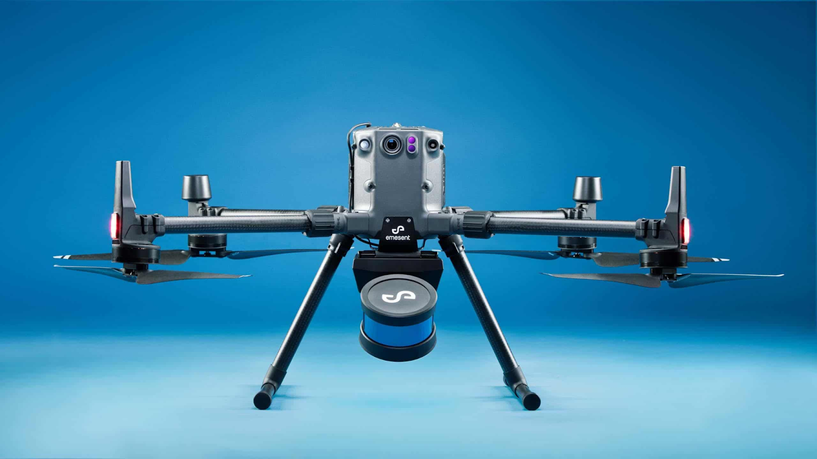
Hovermap offers revolutionary advantages to challenging above ground, underground and GPS-denied environments. Underground mines, tunnels, bridges, telecom and transmission towers and many more can now be mapped and inspected safely, without putting staff at risk.
The different, but similar, individual focus and expertise uniquely augments their mutual business development. Qntfii primarily focuses on handheld/ground level laser scanning, including indoors while Harkin brings drone and aerial data capture to the business equation. Harrigan also coordinates training and education services as part of their joint work. Even though areas seem uniquely distinct, their services overlap on many projects. One of their shared goals is to introduce drone, photogrammetry + LIDAR technology in a way that is both easy and cost effective for small-to-medium AEC (Architecture, Engineering, Construction) firms, as well as municipalities at the local town/village level to adopt.
Selected Projects
Downtown Troy
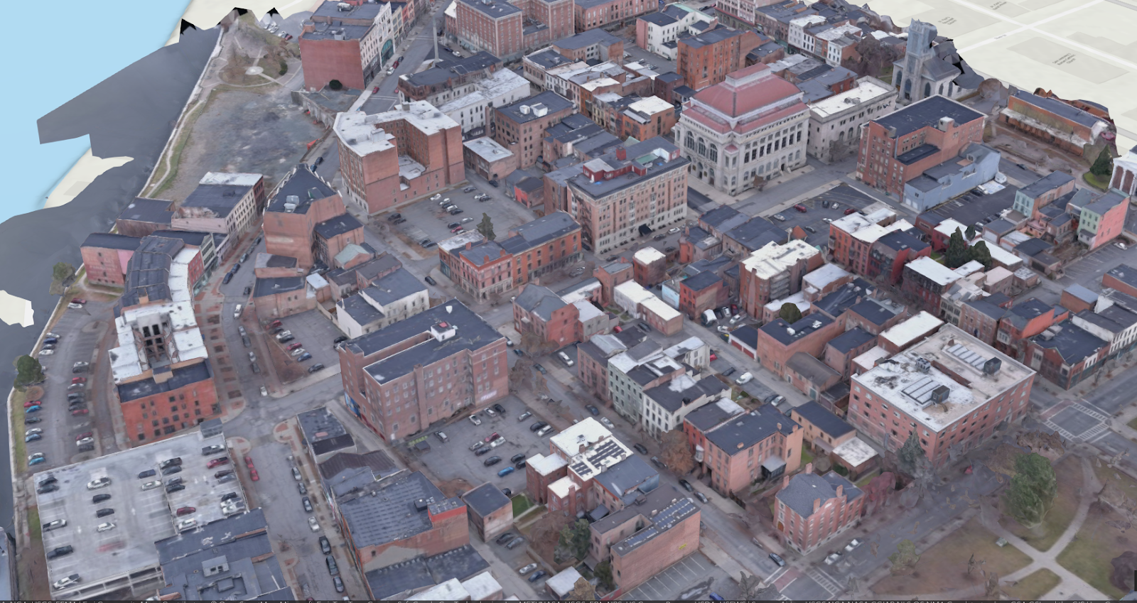
This was a proof-of-concept project employing a truck-mounted Hovermap to collect street level 3D data of a portion of downtown Troy, NY at 4 AM. This work was then followed by a couple of short drone flights during the day to collect well-lit imagery that was then processed in a standard photogrammetric software package. The two datasets were then merged to colorize the LiDAR data from Hovermap.
Cohoes Power Plant
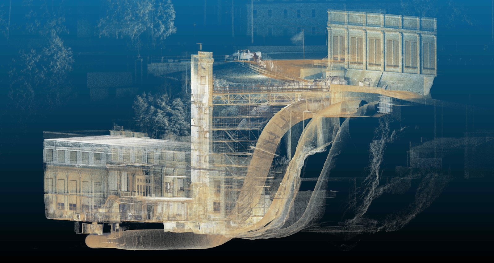
Power plant operators were interested in documenting the entire site (including a penstock tube) using LIDAR. Hovermap played a critical role obtaining 3D data of parts of the plant which would have been impossible or very costly to collect. In one application, Qntfill and Harking were able to place the Hovermap (secured in a protective aluminum cage) through an insertion point in the penstock tube and then lower it 50-60 feet inside the tube, mapping the geometry and condition of the penstock interior.
Site Development
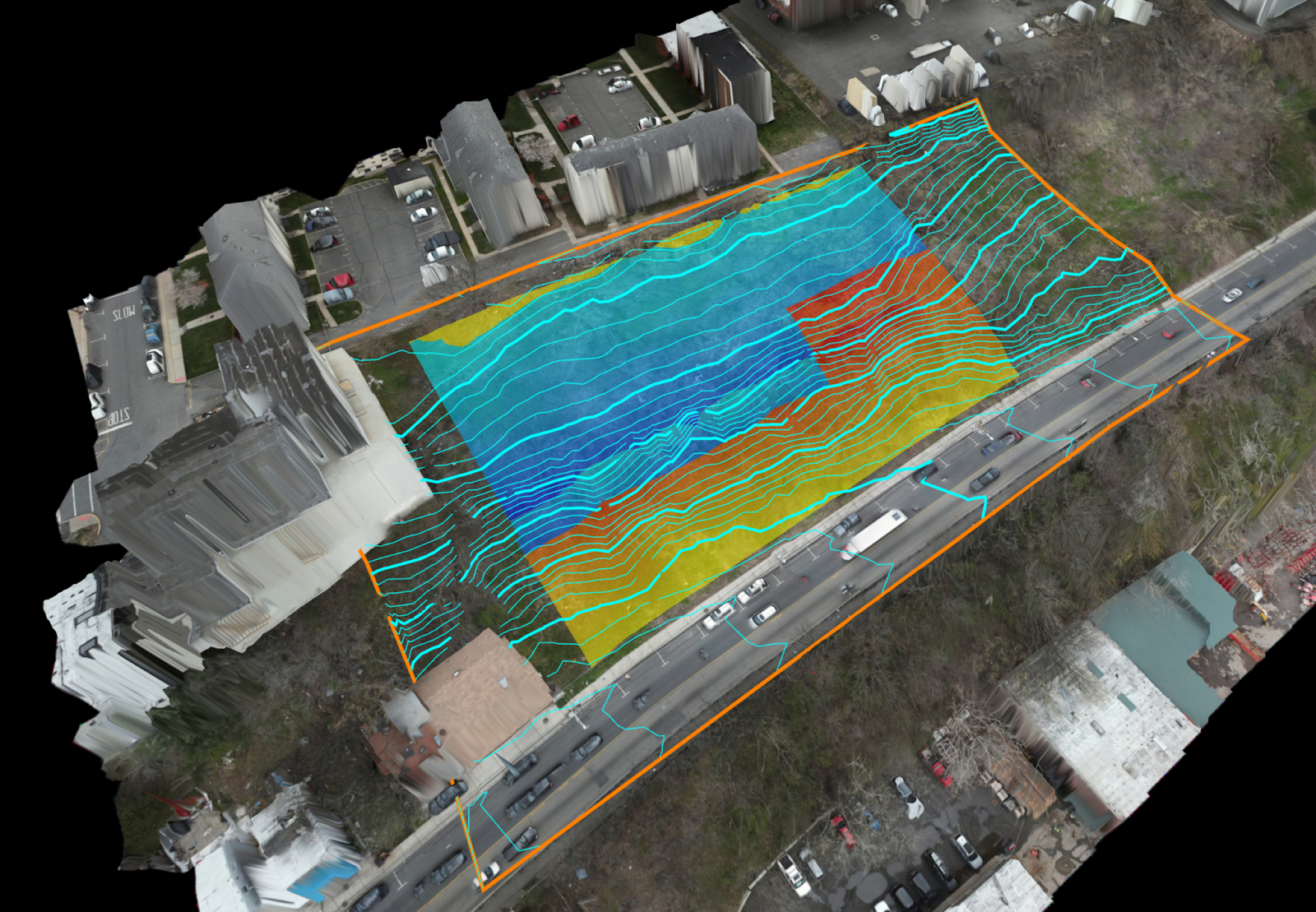
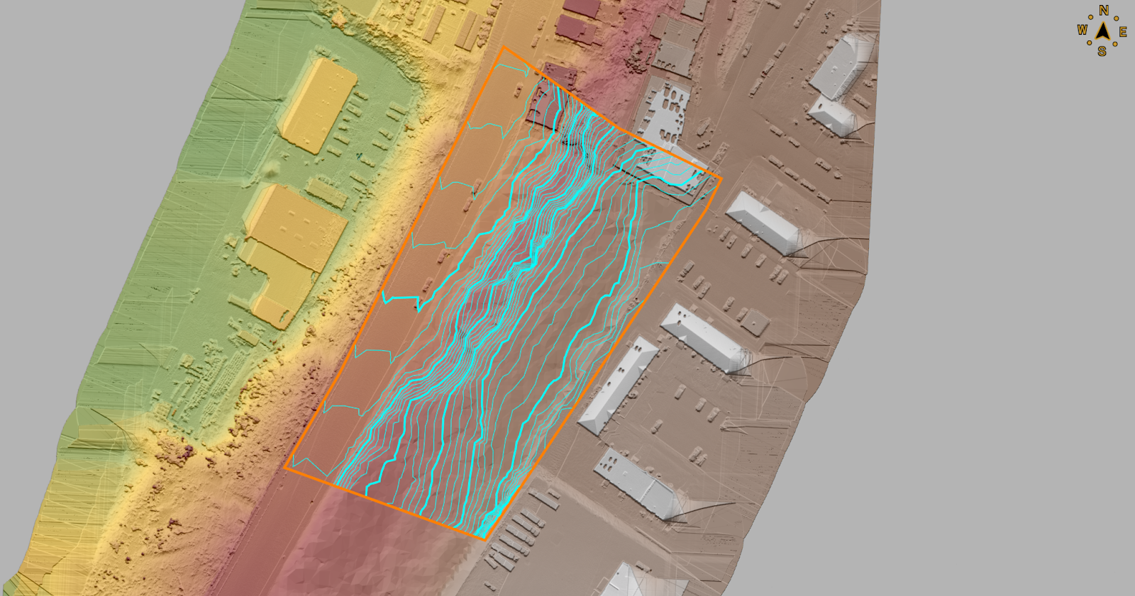
A DJI M300 drone with L1 LiDR was utilized by Harkin to produce bare-earth surface and contours for a new development in the Tri-State area. Data was processed using DJI Terra (LiDAR) and Agisoft Metashape Photogrammetry software to provide up-to-date orthomosaics of the site.
By using the LIDAR-acquired surface, a 3D model was produced from excavation plans to determine the amount of cut and fill of earthwork required onsite. The 3D model and volume calculations provided by Harkin allowed the site engineer to quickly adjust excavation plans to balance the earthwork onsite, greatly reducing the amount of trucks needed to bring in fill material, or take away excavated material. Cut/Fill calculations, contours, and surface were produced using Virtual Surveyor. (Both images generated from Virtual Surveyor).
Harbors and Ports
In the Baltimore Harbor, U.S. Navy and commercial port operators were interested in knowing the condition of port/pier infrastructure as very little existing documentation (as-built plans) were available for facility planning purposes. Qntfii flew a Hovermap drone to identify available space for vessels and equipment, as well as to establish the general configuration of the port(s) and arrangement of vessels currently berthed in the harbor.
Additionally, the two firms have combined on a wide-range of projects in government and industry including, but not limited to, the following: NYC Department of Environmental Protection (NYCDEP), New York City Economic Development Corporation (NYCEDC), Village of New Paltz, NY, Town of Oyster Bay, NY, U.S. Marine Corps, U.S. Naval Information Warfare Systems Command (NAVWAR), and The New York Times.
“The drone market will most definitely continue to grow across the New York State, particularly as professional groups continue to come together and work together on common goals”, notes Harrigan who serves as Secretary for the NY chapter of AUVSI (Association for Unmanned Vehicle Systems International). The chapter represents unmanned (drones, ROVs, robots) operators and businesses across the state and is probably the largest “drone” specific organization across the U.S.
Summary
“So much of this industry is geared towards “enterprise”, big cities, and large – systems which requires a lot of manpower, IT, and intensive training to use. Our partnership focuses on bridging the gap to the small and mid-size organizations”, adds Harrigan.
The two believe users don’t need to be large engineering/surveying firms or a state level department to have a successful drone and reality capture programs. Both Gutelius and Harkin believe the best impact the UAV technology has is when it is working for smaller organizations.
Contact
Bill Gutelius
Qntfill, Inc
1-518-406-0055
www.qntfii.co
info@qntfii.com
Scott Harrigan
Harkin Aerial
1-516-584-3035
www.harkin.io
info@harkin.io
Editor’s Note: The 2024 IEEE Systems and Technologies for Remote Sensing Applications Through Unmanned Aerial Systems (STRATUS) is May 20-22, 2024 in Syracuse, New York