Company Name: Tyler Technologies
Business Unit: ERP & Schools Division, Transportation Solutions (formerly Versatrans)
Website: www.tylertech.com
Established: 1966
THE COMPANY
Tyler Technologies, Inc., is a leading provider of end-to-end information management solutions and services for local governments. Tyler partners with clients to empower the public sector — cities, counties, schools and other government entities — to become more efficient, more accessible and more responsive to the needs of citizens. Its mission-critical applications provide the public sector with the ability to streamline and automate operations, resulting in improved productivity, reduced costs and continual process improvement. Tyler’s client base includes more than 14,000 local government offices in all 50 states, Canada, the Caribbean, the United Kingdom and other international locations. Forbes has named Tyler one of “America’s Best Small Companies” eight times, and the company has been included six times on the Barron’s 400 Index, a measure of the most promising companies in America. Tyler provides a broad line of software products in seven main solution areas: appraisal and tax; courts and justice; ERP financial; planning, regulatory and maintenance; public safety; records and documents; and K-12 schools. Tyler has over 400 customers in the State of New York. Customers include large counties such as Nassau, Suffolk and Westchester as well as municipalities such as City of Buffalo, Rochester and Yonkers.
Versatrans started as a transportation planning consulting firm in 1965 and began developing software in 1980. For more than 35 years, Versatrans has developed the leading technology for school professionals to deliver the best service to their districts. In 2008, Versatrans became part of Tyler Technologies, which today employs more than 3,600 professionals. Since that time, the Versatrans® product line has been maintained and supported, and the number of development resources assigned to the product line have nearly doubled. Tyler’s transportation solutions are the software of choice among more than 1,600 school districts and pupil transportation service providers in the United States and Canada. In the State of New York, Tyler transportation solutions are used in over 280 school districts including large school districts such as Buffalo Public Schools, Williamsville Central School District and North Syracuse Central School District, but also in small school districts such as Fort Plain Central School District, Candor Central School District and Broadalbin-Perth Central School District.
PRODUCTS AND SERVICES
Tyler’s transportation solutions are built to factor together district policies and student information with hazard restrictions and realistic bus speeds. This provides safe and accurate bus stop locations and optimal routes that save money. By geocoding with the latest GIS technology using county maps, and taking into account cross restrictions, hazard zones, predator locations and more, the software picks up students from their exact location and assigns them to the safest stop. The Tyler team is composed of industry transportation professionals such as former directors, trainers, routing experts and drivers which, combined with experienced software engineers, apply their expertise and latest technology to transportation solution products, implementation and support.
Tyler’s transportation solutions include Traversa®, the Versatrans suite and Tyler Drive™.
Traversa
Traversa is Tyler’s integrated, comprehensive transportation management system. Traditionally, transportation software has been offered piecemeal, with different interfaces, different data sources and different requirements for training and installation. Traversa offers a seamless user experience for:
- Bus routing
- Activity trips
- Work order tracking
- Fleet maintenance
- Automated vehicle location (AVL)/GPS tracking
In addition to the areas mentioned above, Traversa’s core functionality includes entity management (students, vehicles, employees, etc.), messaging and alerts, planning and reporting. Traversa is a cloud-based service supported by Tyler experts and hosted in Tyler’s SSAE16-certified data center. Tyler’s GIS services department converts a client’s data and helps verify client maps. Tyler’s transportation team provides training and data security and – when needed – disaster recovery.
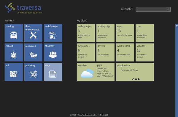
Traversa Dashboard allows school district transportation personnel to see a comprehensive view of everything they need for routing, planning and fleet maintenance.
Traversa’s technology stack incorporates portions of ESRI’s mapping software and can also interface with third-party data providers to show real-time traffic conditions, construction projects, city planning, evacuation routes, weather and more. A user can select a bus stop and zoom in to inspect the streetscape for possible safety issues. Traversa even helps a user respond to change. If a bridge washes out, he or she can quickly find an alternate path and print the new directions for drivers to use.
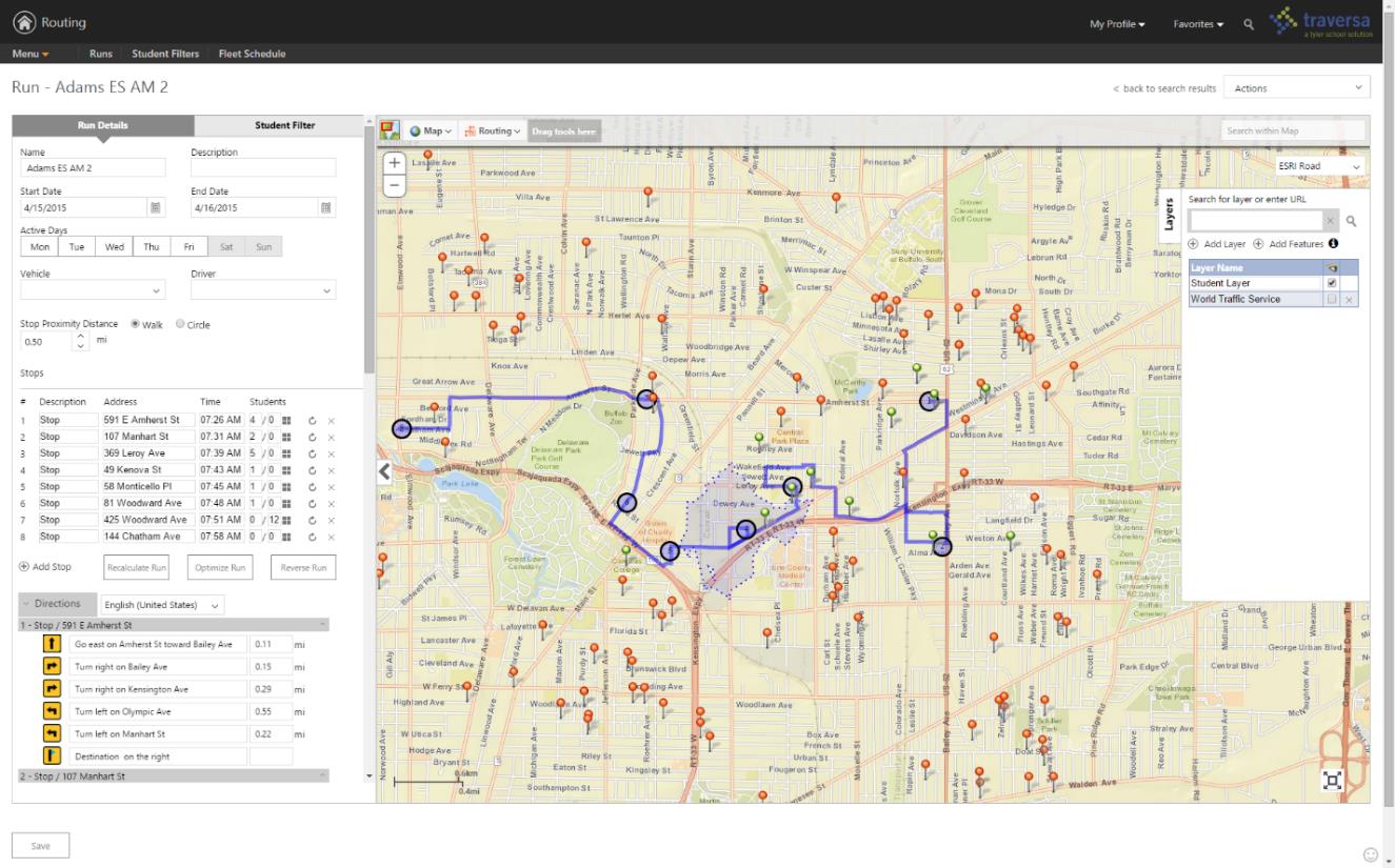
Traversa Routing allows a school transportation router to build daily runs, assign students to stops, generate driver directions, assign vehicles/drivers and more.
Traversa AVL brings all vehicles to one screen for the dispatcher to monitor them in real-time. Users can filter for a specific vehicle, date or time and follow the path of that vehicle. They can also assign geofences for alerts and much more.
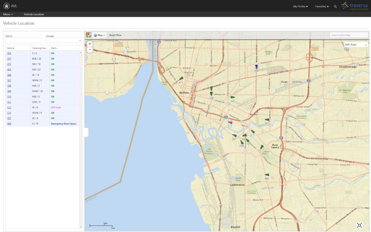
Traversa AVL allows users to view current and historical data related to the location, speed, and direction (N, E, S, W) of the entire fleet of GPS equipped vehicles.
To learn more about Traversa, follow this product overview video.
Tyler Drive
Tyler Drive is an innovative, mobile device designed for the school bus driver. Mounted on the school bus console, Tyler Drive’s 4G service and cloud-based software closes the gaps in school bus transportation. It stems the losses caused by outdated timekeeping software and substitute drivers navigating unfamiliar routes. Tyler Drive keeps school buses on course and generates the documentation for reporting and reimbursement.
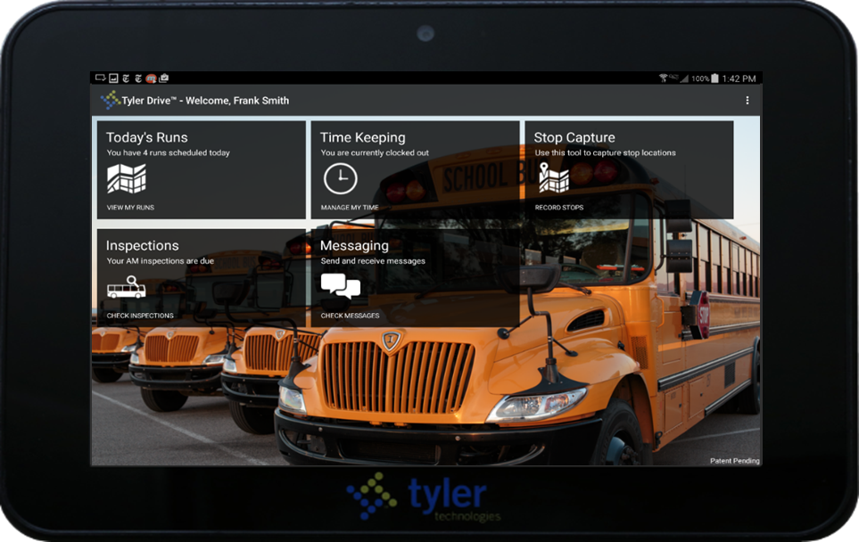
Tyler Drive Dashboard presents drivers with a comprehensive view of everything they need for their shift.
Through integration with Tyler’s student transportation routing and planning solutions, Tyler Drive is able to provide the most comprehensive and reliable route navigation available. Tyler Drive navigation map highlights the planned route with detailed directions to the next stop. If a road is closed, Tyler Drive can redirect the bus to the planned stop. Driver is presented with turn-by-turn directions and a list of students to pick up or drop off as the bus approaches a stop. If the school bus goes off the planned route Tyler Drive re-routes through the shortest path to the next stop in sequence.
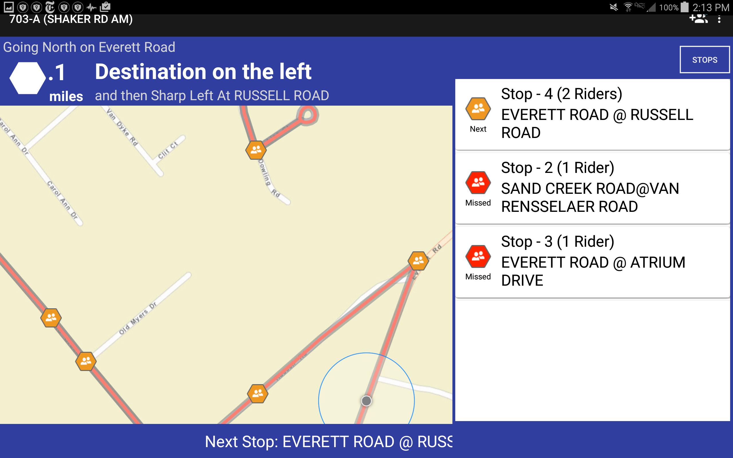
Tyler Drive live navigation assist the bus driver in getting to all the planned stops, picking up students and dropping them off.
Versatrans Suite
Versatrans is a complete school transportation software suite designed to help school districts efficiently and cost-effectively manage day-to-day transportation needs, transporting students to and from their educational programs on time and on budget.
- Routing & Planning is a multi-user transportation management system that can effectively handle multiple destinations within the District’s demographics.
- Versatrans Onscreen® is a GPS fleet tracking solution.
- Versatrans My Stop™ is a mobile application for parents, guardians and students to know exactly where their bus is and what time it will show up at their stop — all from a smartphone or similar mobile device.
- Versatrans Fleetvision® is a maintenance software to manage district fleet. It can auto-generate work orders, track inventory and organize employee certifications.
- Versatrans Triptracker® is web-based field trip software, automates otherwise cumbersome processes like driver selection and personnel approval.
- Tyler Telematic GPS™ is a hardware solution for school buses providing a complete view of vehicle, driver and engine. Tyler Telematic GPS includes: software expandability, driver scorecard, accident reporting, engine data, real-time alerting and more.
Implementation Services
Tyler’s implementation services include training on software functionality and full map preparation, including entering all district schools with grades, other buildings, walk zones, safe zones, bus stops, bell times and more. Tyler gives many options to keep customer maps current, and when the product receives electronic updates from the original map source, functionality is not affected. Tyler’s maps have the ability to utilize GPS information, draw streets simply and accurately, modify street names, and adjust run times to factors like time of day and school bus speeds. The process is automated to provide both efficiency and safety.
Geotab GPS
Tyler has a long standing relationship with Geotab Inc.; the leader in telematic solutions for heavy-duty vehicles. Tyler has been an authorized reseller for the Geotab hardware since 2010 and its close partnership with Geotab over the years has led to Tyler having the distinction as the only partner to have integrated Geotab data within the K-12 marketplace.
Esri Gold Partner
Tyler is an Esri Gold Tier partner, which enabled Tyler to be an industry-leading provider of geospatial solutions and services. As a Gold Tier partner, Esri recognizes Tyler’s commitment to providing enhanced technical and sales support, collaborative engagement and a national and multinational focus. Multiple Tyler solutions use Esri technology, including suites in school transportation, appraisal and tax, planning, permitting and public safety. Tyler has been an Esri partner for more than a decade. Tyler’s new K-12 transportation solution, Traversa, is based on Esri technology.
To find more about Tyler Technologies and their office in Latham, New York, visit their website.
CONTACT
Ted Thien
Sr. Vice President and General Manager, Versatrans
Tyler Technologies, Inc.
23 British American Blvd
Latham, New York 12110
Phone: 800.433.5530 ext. 131840
Email: ted.thien@tylertech.com

