Geospatial Business Spotlight: Mohawk Valley GIS

Company Name:                Mohawk Valley GIS

Website:                               www.mohawkvalleygis.com

Established:                          2003

THE COMPANY

Linda Rockwood founded Mohawk Valley GIS in 2003, after her family relocated to Herkimer County, New York.   Previously, she owned North Country Technology Integration in New Hampshire, working primarily with school teachers to integrate technology and particularly GPS and GIS into the K-12 curriculum.

Initially, Linda had planned to continue offering the same type of services in New York, but found more opportunities early on providing GIS system development, data creation and training to municipalities, and designing custom print maps for organizations.

Mohawk Valley GIS moved to historic Bagg’s Square in downtown Utica in 2014 and has grown to include three full-time staff in addition to Linda, who continues to keep her GIS skills current along with coordinating all business development associated with the firm.    Interns from nearby SUNY Polytechnic Institute  and Syracuse University help when everyone starts bouncing off the walls.  The business received NY Women Business Enterprise (WBE) certification in 2013.

PRODUCTS AND SERVICES

The company has expanded to offer a complete suite of technology services including custom interactive online maps and mobile applications to help promote tourism and recreation, as well as to helping businesses, organizations and local governments towards updating websites to be mobile responsive.

By example, GoCaz.com is an interactive web map promoting four season recreation opportunities throughout the Cazenovia area in the Finger Lakes Region.  This particular project is an example of an adaptive, rather than a responsive, mobile application.  The software checks to see what device is accessing the map, then adapts by “offering” the correct version, either large screen or small device screen, as shown below.

The GoCaz website is device independent - enabling users to access the application from different platforms.

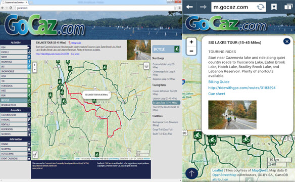
The GoCaz website is device independent – enabling users to access the application from different platforms. The browser version screen is on the left and smartphone version on the right.

Mohawk Valley GIS has also been running two promotional, recreation e-commerce sites for the past six years: the winter-oriented NY Snowmobile Trails  and the summer-oriented ADK Trail Map.   The Snowmobile Map application features an interactive map with a route planner, no-reception-needed trail apps with turn-by-turn navigation, and GPS map offerings including Garmin .img file format overlay maps and regional .GPX track files and waypoints.  The application was built in partnership with over 100 snowmobile clubs throughout New York State and was just awarded a NYS GIS Association Applications Award at NYGeoCon 2015.  Many similar functions are available in the ADK Trail Map.  Both projects feature responsive interactive maps, which respond to the device screen size by repositioning elements or eliminating some functionality.

n addition to a massive catalog of snowmobile trails, the application provides access to information on lodging, restaurants, and related travel services

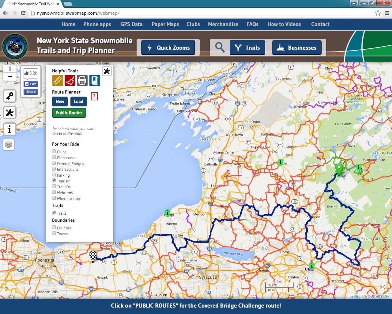
In addition to containing a massive catalog of statewide snowmobile trails, the application also provides access to information on lodging, restaurants, and related travel services.

The route planner and turn-by-turn navigation functionality are built using a pathfinding algorithm which required converting the shapefile representation of the trails to a graph data structure. All geospatial application code in the web map is programmed using Leaflet, an Open Source javascript library.

Core Mohawk Valley GIS services  include GPS data collection, geocoding and digitizing, custom map creation, GIS implementation and training, and GIS data analysis, particularly with regard to big data analysis for predictive analytics and visualization.

Other recent or currently underway Mohawk Valley GIS projects include:

  • Municipality mobile app for Town of Webb/Old Forge, reception required, runs on all mobile devices/browsers, designed primarily for codes enforcement department
  • Municipality mobile app for Warren County, no reception needed, for first responders, focusing on building and structure characteristics
  • Custom paper map design for Vermont Association of Snow Travelers
  • Responsive website for the Herkimer County Chamber of Commerce
  • A unique (at clients request) website, American Electrical Enterprises, which uses a high tech data and chart visualization library
  • Three “big data analysis projects”, all under Non-Disclosure Agreements (NDA), which include  strong geospatial components related to predictive analytics, marketing, and real time data interpretation

To find out more about Mohawk Valley GIS geospatial services and products, visit their website.

CONTACT

Linda Rockwood, Owner

linda@mohawkvalleygis.com

114 Genesee Street, 3rd floor

Utica, NY  13502

315-624-9545

www.mohawkvalleygis.com


Geospatial Business Spotlight: Spatial Analytix

Company Name:        Spatial Analytix

Website:                      http://www.spatialanalytixllc.com/

Established:                2015

The Company                                                       

Spatial Analytix is currently under the leadership of Ben Houston (CEO) and Matt Mercurio (GTO).  Together, both bring a wealth of experience in GIS and mapping to the growing Unmanned Aerial Vehicle (UAV) mapping market in New York State and beyond.

Most recently, Matt was GIS Manager in Allegheny County, PA and before that Project Manager at the Institute for the Application of Geospatial Technology (IAGT) in Auburn, NY. He also continues to be a principle and founder at Civic Mapper (www.civicmapper.com). Ben has spent the past six years as founder and officer at GroundPoint Technologies (www.groundpointllc.com) and prior to this worked with Matt and other colleagues at IAGT in both NASA and New York State Department of Environmental Conservation (NYSDEC) funded geospatial programs.

Spatial Analytix was formed in early 2015 to support a growing need in the UAV data processing market.   The current emphasis in the UAV market is on platforms, hardware, software and cloud based solutions, not the data. Spatial Analytix believes that the next few years will be characterized by market confusion over data quality and deliverables as even experienced geospatial professionals sort through the fog. By bringing a focus on data quality and useful deliverables, Spatial Analytix moves UAV data collections beyond being just imagery projects to producing high quality, plug and play geospatial data.

Geospatial Services   

Spatial Analytix focuses on geospatial data in terms of the data quality triangle:

SA1While much of the current discussion in the UAV market focuses on the wow factor of precision, Spatial Analytix also considers temporal components along with verifiable accuracy in the data deliverables to ensure customers get what they want, when they want it. It’s the three elements together that bring real value to the data.

Typical outputs from automated processing (i.e., web based solutions) normally include point clouds, terrain models, and image mosaics (often labeled with the misnomer of “orthomosaics”). Such deliverables are usually acceptable for surveillance and monitoring uses, but for true GIS and engineering mapping applications, automated processing solutions leave a big data quality gap. Artifacts, noise and flight line overlap issues can clutter the point cloud and skew surface models, making for inaccurate contours and messy mosaics. Automated orthophotography can show up with smearing and ghosts, and usually do not include optimal image and cut line selection. Although available off-the-shelf geoprocessing tools in this space are becoming more powerful and functional each day, Spatial Analytix combines the right mix of quality tools, technical knowledge, and artisanal experience to get projects to come out right. The first time.

Clients can access raw data and processed deliverables through standard file systems, or as a URL which can be delivered across an enterprise for data visualization and exploration. No longer do the deliverables need to be sent to a GIS or CAD operator to put on screen for a supervisor or program manager. Live, web based delivery of hosted data is now standard. Platforms range from Google Maps to ArcGIS Online to Pictometry Connect. When compared to traditional photogrammetric and aerial survey products, Spatial Analytix deliverables are designed to be not only equivalent…but better.

Ortho-Image

Ortho-Image

Spatial Analytix is developing a network of regional UAV data collectors offering standard services including:

  • Point Clouds (LAS format)
  • DTMs (full surface)
  • DEMs (bare earth surface)
  • Contours
  • Breaklines
  • Planimetrics
  • Image mosaics/orthomosaics
  • Volumetrics
  • Drainage
  • Vegetation/Landcover/Impervious surface mapping
Colorized point cloud

Colorized point cloud

In the near future, Spatial Analytix product enhancements will include:

  • Oblique imagery integration (Pictometry Connect integration)
  • GeoVideo
Typical UAV Flight Line Configuration Developing 3D Model

Typical UAV Flight Line Configuration Developing 3D Model


Spatial Analytix offers Virtual Geospatial Technology Office (vGTO) services to partner companies looking to leverage UAV and geospatial technologies by providing authoritative consulting support on such things as optimal flight planning and data processing, enterprise data management, and web based solutions. Whatever the UAV geospatial data deliverable is –  imagery, elevation, vector, or raster –  Spatial Analytix is confident that users have never seen data like this before.

Contact:   

Ben Houston, ben.houston@spatialanalytixllc.com

Matt Mercurio, matt.mercurio@spatialanalytixllc.com

Website: spatialanalytixllc.com

Facebook: /spatialanalytix

Twitter: @spatialanalytix

(412) 368-6015

GTO © Professional Services

SA7


Geospatial Business Spotlight: Mapzen

Company Name:                Mapzen

Website:                              https://mapzen.com/

Established:                        2013

The Company

Mapzen is currently under the leadership of longtime colleagues Randy Meech and Brett Camper.

Together they come with years of experience in mapping and product development. Previously, Meech was Chief Technology Officer of Mapquest and Camper was Director of Product and Engineering at Kickstarter.  Mapzen consists of a professional staff that includes software engineers, product managers and mobile application engineers located at the offices in New York , San Francisco, Berlin, and several remote sites.

Mapzen was created on a shared vision to establish an open, accessible, and resilient mapping ecosystem.  Today this vision is being implemented and facilitated through the Samsung Accelerator  which provides the financial framework and stability.   Mapzen supports the geospatial community through building tools and promoting open source map technologies which follow a long tradition of community-powered cartography.

Geospatial Products and Services

Mapzen products and services are focused in four core areas:

  • Search (geocoding)
  • Graphics
  • Navigation
  • Open Data

Mapzen staff and developers leverage GitHub extensively as an environment to communicate technical issues with colleagues on projects.  It provides access control and several collaboration features, such as a wikis, email threads, and basic task management tools for every project.

Illustrative examples of Mapzen projects include:

Tangram

Tangram is a map renderer designed to grant significant levels of control over map design. By drawing vector tiles live in a web browser, it allows real-time map design, display, and interactivity.  Using WebGL, Tangram leverages the graphics card to a new level of cartographic exploration. Animated shaders, 3D buildings, and dynamic filtering can be combined to produce effects normally seen only in science fiction.

Day/Night

Tangram draws maps live in a browser enabling developers to update styling properties in real-time, instantly. But changing the color is just the beginning – as every Tangram map is a 3D scene, you also have control over lights and cameras.

In this view just south of Central Park in Manhattan,  an isometric camera’s perspective is varied along with the color and direction of a light (morning), resulting in a time-lapse drone’s-eye view.

In this view just south of Central Park in Manhattan, an isometric camera’s perspective is varied along with the color and direction of a light (morning), resulting in a time-lapse drone’s-eye view.

Crosshatch

Using Tangram’s plain-text markup language, developers can write graphics card programs (called “shaders”) and even JavaScript to add interactivity, mix data sources, and control the design of maps.

This example of lower Manhattan uses a shader to color geometry with hand-drawn textures, blending between them based on the color, angle, and amount of light on each face.

This example of lower Manhattan uses a shader to color geometry with hand-drawn textures, blending between them based on the color, angle, and amount of light on each face.

Tron

Tron uses procedural shaders to create a view of the future.  The shaders, defined by mathematical functions, are applied to various data layers with UV maps, just like texturing an object in a 3D application like Blender.

TangramTron

Other current Mapzen projects include:

  • Vector Tile Service: a free vector and super fast OSM base layer
  • Pelias: a modular open-source geocoder
  • Open by Mapzen: a proof of totally open source and open data app
  • Valhalla: a unique routing engine based entirely on open data
  • transitland: a community edited aggregation of transit feeds

Find out more about Mapzen’s data products, employee blog postings, and additional information for developers on their website.

Contact

Alyssa Wright, VP, Partnerships and Business Development, President of OpenSteetMap US, and co-organizer of the GeoNYC Meetup group.

Focus on New York State Geospatial Businesses

Along with general observations and comments on the state of geospatial technologies in the Empire State, including occasional posts associated with the Blue Highways of GIS series, eSpatiallyNewYork introduces a new column:  Geospatial Business Spotlight.

Posts in the column will not only focus on long-time Empire State GIS service providers and consultants but will also include the new generation of geospatial businesses and start-ups in the  mobile, Cloud, research and development (R&D), and   Open Source  spaces.   While the growth of business GIS applications is apparent in many existing private sector markets (e.g., real estate, banking, retail, insurance, telecommunications, market research) – whose growth continues to be augmented by expanding mobile technology and location analytics –  many of the same business GIS solutions will be adopted by government programs as public funding for geospatial programs continues to be limited.  Regardless of either old or new – all companies highlighted will be ones making significant contributions to the growth and development of geospatial technologies across the Empire State. Continue reading