AGOL viewer, data HUB, and other geospatial tools used in helping develop WITHIN East Side Plan
Community focused GIS projects are always a favorite of mine to write about. Highlighting how geospatial tools can be used by community groups – including nonprofits which are often project sponsors – to better help visualize and understand the vast array of environmental, regulatory, business and public health, and cultural data which impacts their daily lives. One such project located in Buffalo’s east side was brought to my attention in a recent communication with Lisa Matthies-Wiza, Director of Geographic Information Services at Erie County.
WITHIN East Side
The WITHIN East Side project is one of many projects of LISC Western New York (WNY) and its larger parent organization LISC New York. program. WITHIN East Side focuses on simplifying the neighborhood planning and community development process, and ensures development is driven by resident leaders and community groups. As an open, inclusive, community-driven initiative, WITHIN East Side brings together neighborhood voices, trusted partners, and supportive funders in an effort to better the wellbeing of residents using their own visions. Together with LISC NY, the WITHIN East Side stakeholders collaboratively identify projects that sustain the positive momentum happening in local neighborhoods.
In early 2020, LISC NY began planning with community partners in three geographic focus areas in the East Side under the WITHIN East Side program. The East Side of Buffalo, which is the heart of Buffalo’s Black community was chosen as it is purposeful to build upon and lift up the long-time visions of residents and community leaders in neighborhoods most impacted by historic disinvestment, environmental, structural, and systemic racism. The additional impact of the racist mass shooting on May 14, 2022, that killed 10 people, at a local supermarket within the planning area, furthered the importance of amplifying the community’s voice and vision for the future.
The project was designed as a two-pronged approach–integrating economic development and quality-of-life planning. Closely intertwined, both economic development and quality-of-life planning require understanding community history and dynamics, collaboratively identifying projects, building relationships with diverse stakeholders, and turning community priorities into progress.
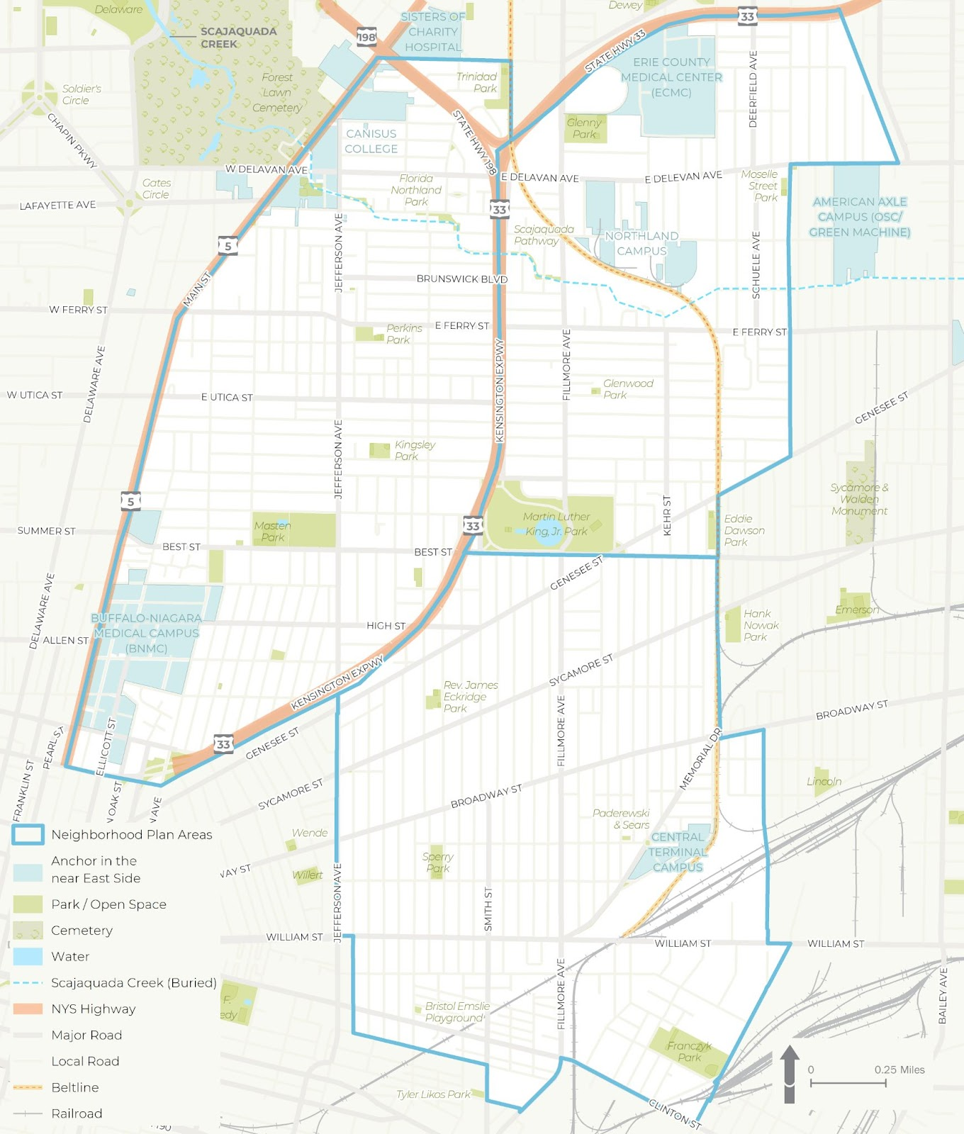
The WITHIN East Side project was broken into three distinct study areas – each of which was studied in more detail for a wide range of demographic, cultural and economic development issues
Background
LISC NY contracted with Prospect Hill Consulting (PHC), a local minority and women owned consulting firm which had responded to a formal Request for Proposals (RFP) which was issued in January 2021. GIS mapping and analysis was a requirement and the LISC NY team knew GIS services were important to supporting the overall East Side project. PHC was selected to perform elements A (GIS Mapping [including an online mapping tool request and a data HUB) and B (Scenario Planning). While LISC NY had a vision of what the final plan might look like, PHC was instrumental in assisting LISC NY in developing maps and visualizations used in the final plan and in community engagement sessions throughout the process.
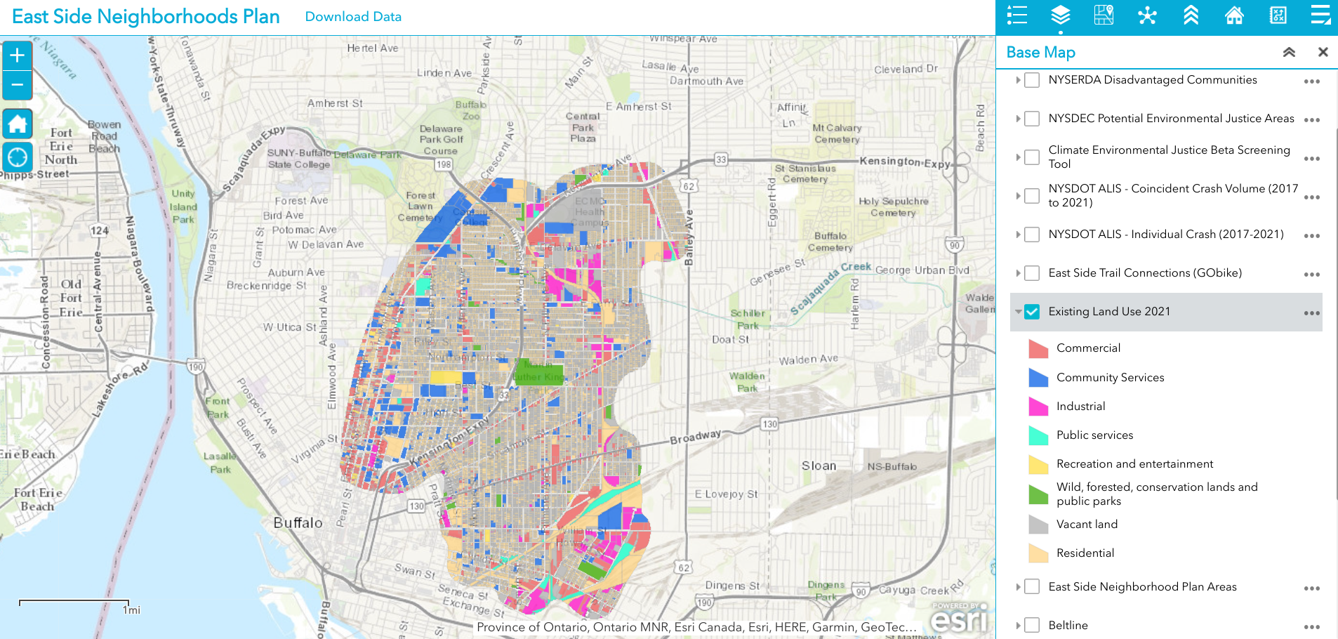
Existing 2021 land use is just one of dozens of data layers in the WITHIN East Side AGOL viewer. The rich database consists of local, regional, state and federal datasets.
Leading geospatial development of the East Side project from PHC was Jenny Magovero, President and Co-founder. Ms. Mogavero has been working in the GIS field for 23 years covering geospatial applications in community planning and environmental sciences as well as work in data visualization and project management. Mogavero created all of the maps in the East Side plan using the ArcGIS client as well as for spatial analysis and modeling. The project web map is ArcGIS Online based with the data stored in a Hub Site (to allow for data sharing) and was designed about halfway through the GIS mapping and analysis task to support the WITHIN planning process itself.
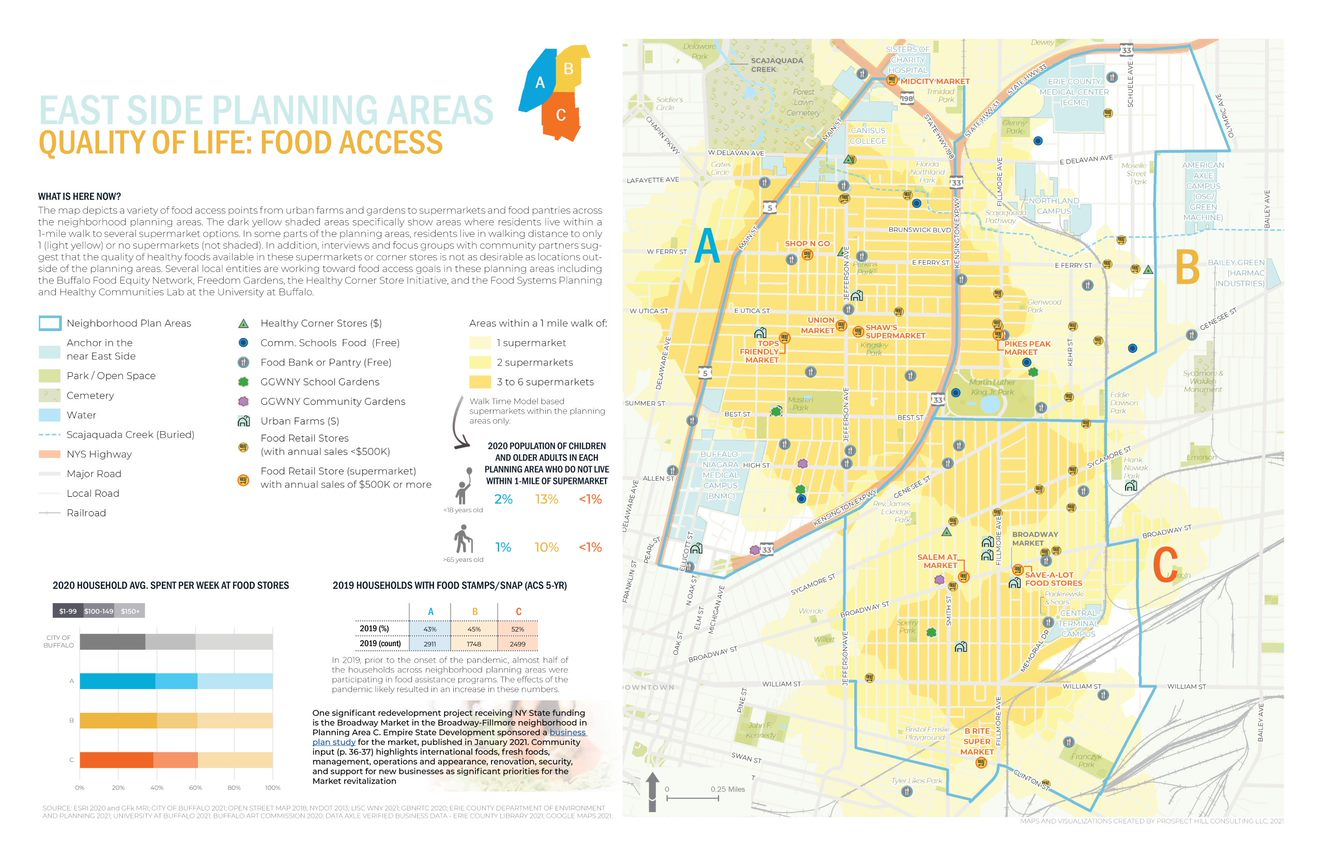
One of the many excellent graphics iWITHIN East Side report. The map on the right identities areas within the study area where supermarkets are located – a significant issue for residents with limited transportation options.
LISC NY wanted to be as transparent as possible and allow stakeholders (i.e. the community/public, organizations, etc.) to work with the data and download and use it if they needed. To this end, the AGOL interactive map was used in community outreach and meetings early in the project and as new data came online (i.e., stakeholders requested to see additional themes) PHC continued to update the AGOL viewer. PHC designed the AGOL viewer to serve as a communication medium that allowed LISC NY to show project progress, survey the community on what themes needed to be covered and/or identify gaps, and to act as a platform to continue engagement with the community in the future.
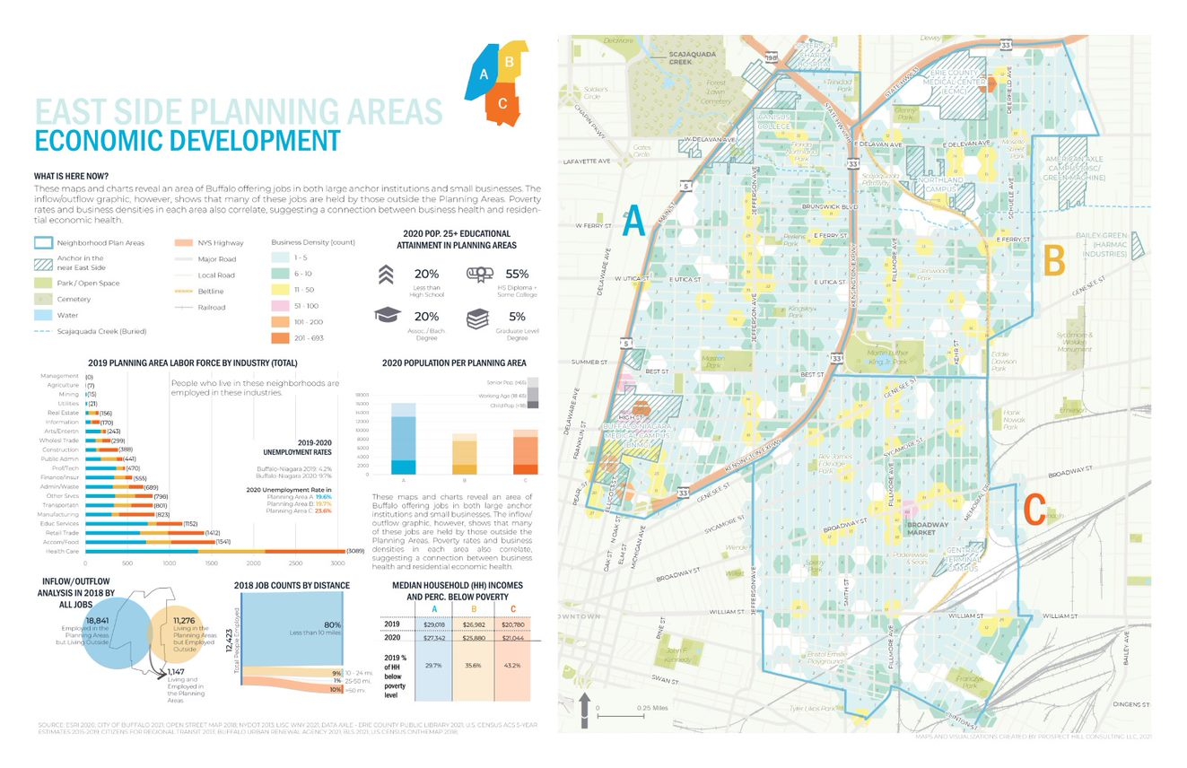
Economic Development issues are paramount in the study such as the role of small businesses, inflow of non-residents that work – but do not live – in the area, as well as the concentration(s) and accessibility of employment opportunities.
Data collection and development was specific to the mapping and analysis that the LISC NY team needed for the WITHIN plan itself. As LISC NY has significant business relationships within the greater Buffalo community, they were able to collect a lot of data from local, state and NGOs. In addition, PHC collected publicly available data from the City of Buffalo, Erie County (parcels, land use, etc.), New York State (NYSDEC, NYSDOT, etc.) and federal datasets (EPA, Census, etc.). Additionally, PHC developed data from reports or datasets that were anecdotally described by stakeholders (like the air quality buffer, buried portions of the Scajaquada Creek, key intersections, etc.). Project data was also obtained from utilities, Google, OpenStreetMaps, and ESRI.
Most of the project data is made available through the LISC WNY Open Data Hub which was also designed and continues to be supported by PHC. (Some providers did not want their data to be shared so it is only available for viewing in the application.)
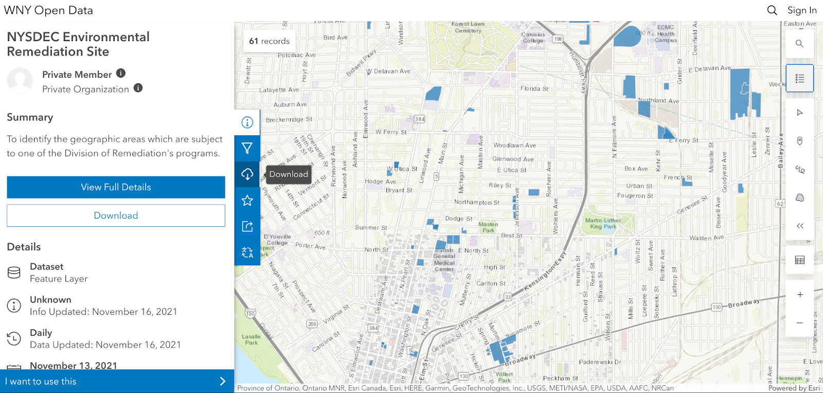
No AGOL account is necessary to access the HUB and tags help users to easily jump to specific themes of data presented in the final plan for download.
PHC used a bevy of GIS, statistical packages, and desktop publishing software tools to generate the maps and graphics in the report including:
- ArcGIS Online to collect stats for the neighborhood that were ACS 5yr census based (https://doc.arcgis.com/en/arcgis-online/analyze/enrich-layer.htm)
- Geospatial processing tools to buffer, clip, summarize, and run overlay analyses
- Spatial Analyst tools to develop walkshed layers (from points provided by Walkscore)
- Tableau Desktop and Excel to conduct data exploration to emphasize trends (or data insights) with graphs/visualization on map layouts
- Adobe InDesign for page layouts and other graphics to be consistent with the LISC NY brand book (design guide) including colors, fonts, and logos.
- ESRI’s Hexagon sampling tool to visualize parcel data classes (i.e. land use, vacant parcel density, ownership) at the scale of the plan areas.
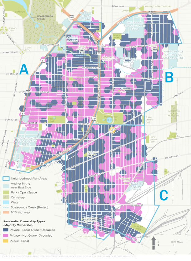
Residential ownership type is an important variable in urban studies. Data presented in the figure above suggests there continue to be many opportunities in increasing owner occupied properties in the study area
Summary
While consulting architecture and engineering companies continue to expand their geospatial offerings to governments and regional programs in 2022, particularly in the infrastructure and public works space, planning firms such as PHC serve in a unique space focusing on efforts which include applying geospatial tools as part of important community-based projects which often include significant public input and involvement. Tools such as AGOL provide a great framework in which to engage the public with regard to adding and removing data content and visualizing potential scenario outcomes. A particularly useful tool given the enormity of the data used in the WITHIN East Side plan.
Reflecting on PHC’s involvement in the study, Jenny Mogavero notes:
“LISC NY is an integral part of, and key economic engine within the Western New York region. Prospect Hill was honored to partner with the LISC NY to use GIS data, visualization tools and spatial analysis methods to not only present the existing conditions of our city’s East Side neighborhoods, but also reveal the deeper insights that occur when we overlap data-driven stories across multiple thematic lanes. We were thrilled that our work supported the teams’ consensus building goals to develop a vision of a prosperous future for an important part of our City.”
Tyra Johnson Hux, WNY Director of Operations, also reflects on PHC’s work and the use of geospatial tools in the project adding:
“WITHIN East Side amplifies the visions of residents and community leaders in neighborhoods impacted by historic disinvestment, environmental, structural, & systemic racism. Showing their stories through, not only their own words, but also data was critical to helping our stakeholders generate a bold, authentic and comprehensive vision with an emphasis on implementation. PHC supported the WITHIN East Side Plan by working with the project team to identify, collect and normalize relevant GIS data from neighborhood, government, academic and other partners. Additionally, they worked with us to analyze and visualize the community experience through maps and infographics. The online interactive map and data warehouse they developed made it possible to share data in a way that breaks down silos, facilitate strategic planning and continue community conversations.”
Contact
Jenny Mogavero, GISP
Prospect Hill Consulting LLC | Principal
716.432.9053 | www.prospecthill.co
jmogavero@prospecthill.co
Lashay Young, Director
External Affairs for LISC NY
https://www.lisc.org/
LYoung@lisc.org

 EagleHawk was founded in 2016 by