NYS 2016 Geospatial Legislation: The Beat Goes On

Have been a little remiss in the blog content space of late and now trying to play catch up with a couple articles and stories in the works albeit nothing finalized.  With August typically being one of the slower months across the board, it’s always a good time to take a step back and see how the geospatial/GIS profession is growing across the state in context of making its presence known  or at least recognized and referenced in the legislative arena.   This year’s summary provides a little more fodder for discussion and content than in the past couple years – even to the point of dulling the urge to write in that very special way about one of my other favorite New York summertime geospatial topics:  The Geospatial Advisory Committee. The GAC.

State of the State

Always appropriate to start at the beginning of the year with the Governor’s State of the State “Built to Lead” themed speech (January 13th) which did offer some optimism – albeit indirectly – for investment and growth opportunities in geospatial technologies across the state.  Most notably with references in the areas of infrastructure development.  Even though many of the investments itemized in the speech are for major public facilities such as LaGuardia, the Jacob Javitz Center, and Penn Station – btw to the tune of $100 billion –  there is still room for enthusiasm in the GIS community hoping that even small portions of the $100 billion investment can trickle down to local government geospatial  programs to  support bridge and road management initiatives, public water/storm/sanitary systems rehabilitation projects, evolving resiliency projects, and many other infrastructure related efforts.  And best of all, providing funding opportunities for the many deserving GIS and civil engineering businesses which continue to support and help build statewide geospatial capacity. While it’s almost certain that the $100B funding is spread out over many appropriation bills, one can see the magnitude of the statewide infrastructure focus and priority by performing a keyword search on “infrastructure” in the New York State Bill Search form. Results? Fifty-seven bills match the search criteria.  Granted, not every bill is specific to geospatial & infrastructure – but it’s a damn good starting point for the statewide geospatial community.  And you can be well assured our brethren in the engineering, surveying, public works and aligned disciplines are already well engaged in tracking down the funding.  And btw, if you’re really interested and by comparison, do a similar search on keywords such as geospatial, mapping, geography, or GIS – and make note of the search results.  I’m by no means an expert in using the form, but by using it only casually, one can get a sense of the potential funding sources.

As in past State of State speech agendas, the governor makes reference to other should be GIS staple disciplines such as economic development (REDCs: Regional Economic Development Councils) and tourism – two very high level and visible government programs which the statewide GIS community has yet to make broad and sustaining inroads with.  Granted the current state administration’s REDC organizational chart is problematic in that these boundaries do not coincide with the existing NYS Association of Regional Councils boundaries, GIS-based economic development and tourism websites should continue to be a top priority for every county and/or regional planning commission across the state.

 2016 Bill Search

Certainly not an exhaustive list, but the following does provide a general flavor of the types of  geospatial/GIS-related bills which were either newly introduced or carried over from previous years.  Search results included:
Continue reading

10 Questions: Dale Morris

Dale Morris is one of New York State’s most recognized and senior GIS statesmen.  With a distinguished civil service career spanning 38 years, he has contributed significantly to the NYS GIS community in many capacities to say the least of directing one of the most established GIS programs in the state at Erie County – and its far reaching influence in western New York.  Ten questions seemed like a slight to an individual with such a body of professional work, so the eSpatiallyNewYork editorial team gave him permission to push it to 15 questions. Or something like that.  Enjoy.

eSpatiallynewyork:  How long have you been with Erie County?

Morris:  I’ve been in the Department of Environment and Planning since 1981. Prior to this I worked as a Planner for the Town of Amherst, NY and before that the Erie and Niagara Counties Regional Planning Board. I graduated from Cornell University with a Master’s Degree in Regional Planning in 1977.

eSpatiallynewyork:  When did you start doing GIS work?

Morris:   Working initially as a Planner for Erie County presented  many opportunities for making and using maps. In the 1980s we were still using Mylar, zipatone, and Leroy Lettering Sets for making maps, which is tedious, time consuming, and not easy to change. I began to investigate the world of digital mapping, which was still in its beginnings as a desktop product. I started with the DOS version of MapInfo. I recall how amazed we all were that we could do something as simple as draw the County and municipal boundaries on-screen. Looking back on it now it all seems so rudimentary!  Regardless of how basic it was, my Division became known for our ability to make computer drawn maps. At that time there wasn’t much concern about the database behind the maps- it was enough to be able to draw and edit maps digitally rather than by hand.

As desktop mapping grew in popularity through the 1990s a number of County departments began independently looking into it. This usually resulted in them calling me to ask for advice or data. Of course, this also meant that everyone was using different systems, and at that time it made exchanging data between systems very difficult or impossible. It was a classic case of disjointed silos of data and applications.

A change in County administration in the late 1990s brought new management in our department, and I was challenged to prepare a white paper for moving the County further forward into the digital mapping world. I proposed creating a new County Division that would be empowered to centralize decisions relating to geospatial technology (by then we could use terms like “geospatial” without getting blank stares!). The Office of Geographic Information Services (OGIS) was born in 2001, and I have been the Director since then. So for me personally, my career started with both feet in the urban planning field, then a gradual shift to one foot in planning and one in digital mapping, and then finally both feet in GIS. I do very little “typical” planning anymore, even though OGIS is part of the Planning Division.

While OGIS is an Office within the Department of Environment and Planning, only a portion of our work is related to this department. We work very closely with our IT shop to maintain and operate the County’s GIS technology infrastructure, and with other departments and outside agencies who either use our enterprise GIS technology or who need direct assistance with their mapping needs.

eSpatiallynewyork:  What’s the relationship between your office and Niagara County?

Morris:  We have a formal Intermunicipal Agreement (IMA) with Niagara County for GIS Services. The agreement is for a five year period and we are well into the second of these five-year agreements. Erie County hosts Niagara County’s geospatial data and provides on-line mapping services to Niagara County. The two counties are connected by a high-speed microwave link, which operates very well. In essence, Niagara County is simply like any other Erie County department that taps into the Erie County enterprise GIS network. In addition to providing Niagara County this service for a fee, the IMA provides a framework for backup of GIS data between the two counties, and as well defines a GIS “mutual aid” protocol for sharing of GIS resources and staff in the event of an emergency.
Continue reading

Queensbury Geospatial: A Model for NYS Town Government GIS

Northbound New York State Northway Exit 20 leads to the Town of Queensbury which is the seat of Warren County.  With a 2010 population of 27,901 the town covers nearly 65-square miles including shoreline along Lake George and lands within the Adirondack Park.  Further into town, several of the usual NYS town government program offices are located at 742 Bay Road including staff and resources which support the town’s geographic information system (GIS).

GIS Background

Prior to 2002, Queensbury officials had worked with consultants to establish initial GIS capacity including the creation of ArcIMS applications and investing in multiple ESRI desktop licenses.  In 2002, the town’s GIS initiative changed significantly with the hiring of George Hilton.  Hired as a GIS Specialist and planner, George was brought onboard to build and advance the town’s  GIS program.

Prior to arriving in Queensbury, George had honed his GIS skills while a student at Central Connecticut State University and later in government positions  in the Denver and Kansas City areas as well as three years with Westchester County.  Now, 15-years after his arrival, George oversees a program which can be considered an exemplary NYS municipal government GIS program.

Current Queensbury Geospatial Products and Infrastructure        

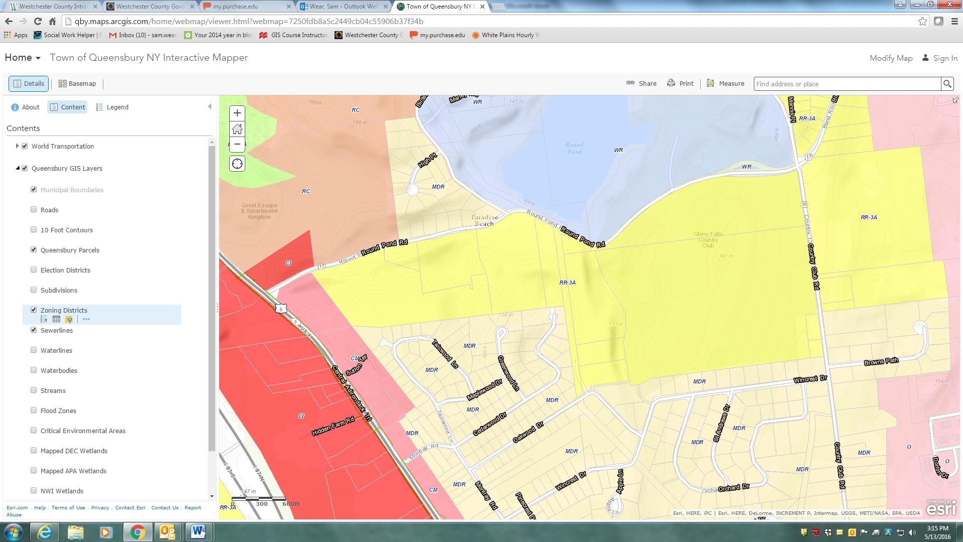
George designs, codes and maintains the Town’s Interactive Mapper (Firefox and IE only) and a host of other ArcGIS.com map viewers including Fire and EMS, Planning and Zoning, and Phase II Stormwater Infrastructure.    He also supports emerging mobile mapping and data collection efforts which includes Trimble GPS units with Trimble Positions to collect data and update feature services and Geodatabases in the field.  The town also collects data (hydrant inspections, site inspections) with ArcGIS Collector using feature services and make maps available through ArcGIS Online.

The Town of Queensbury Interactive Mapper includes many locally developed datasets as well as data from other authoritative sources including Warren County, NewYork State and the Adirondack Park Agency.

The Town of Queensbury Interactive Mapper includes many locally developed datasets as well as data from other authoritative sources including Warren County, NewYork State and the Adirondack Park Agency.

Other software components – much of which has been self-taught – George uses inlcludes Sybase (RPS) and SQL Server with ArcSDE as well as ArcGIS Server, ArcSDE, ArcGIS (Advanced), and Spatial Analyst.  The town is currently at ArcGIS Server 10.22 and are testing 10.4 with plans to upgrade very soon.  He also works with QGIS and Global Mapper from time to time.  Global Mapper has been particularly helpful in importing updated USGS topo quads (DRGs) in GeoPDF format into our GIS.

The Queensbury GIS program has grown from primarily providing support to the Planning Department to becoming a very important resource for many departments across town government.  Both the Town Board and Town Supervisor are very supportive of GIS and recognize how much of an important tool GIS has become to the Town.

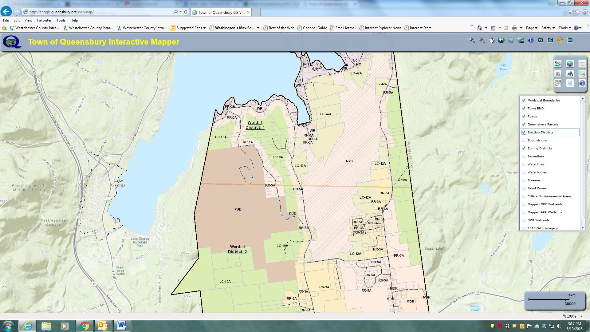
Parts of the Town of Queensbury is actually within the Adirondack Park and therefore subject to stringent land use regulations. This image highlights zoning districts on the southeastern shore of Lake George – within the park boundaries.

Parts of the Town of Queensbury is actually within the Adirondack Park and therefore subject to stringent land use regulations. This image highlights zoning districts on the southeastern shore of Lake George – within the park boundaries.

George maintains an excellent working relationship with Warren County GIS which is under the direction of Sara Frankenfeld where he obtains  parcel data.  The town creates town-wide datasets (zoning, subdivisions, hydrants, infrastructure, environmental, street centerlines, address points, etc) which are then shared back with the County. Referencing her ongoing GIS work with Queensbury, Sara explains:

“George is great to work with and especially in a rural environment where we don’t have any other full-time GIS staff within our respective local governments, it’s so helpful to have a colleague to bounce things off.  He’s a very good sounding board and when I’m considering starting a new project, I often call to get his thoughts.

 We’ve worked closely together on a number of projects.  We recently worked together to streamline the way e-911 addresses are assigned, and this has been a huge improvement to workflows in both of our offices, as well as in the Real Property office, the zoning/building inspectors departments, and the assessors’ offices

 Our current cooperative project is a NYS Archives LGRMIF grant funded project to make the SAM data, along with information about truss roofed structures (as required by a NYS law that went into effect 1/1/2015), and other relevant data such as hydrant locations, available to first responders via an Android/iOS app”.

George also works closely with several state agencies including the Adirondack Park Agency, NYS Parks and Historic Preservation, NYS Department of Environmental Conservation, and NYS Information Technology Services (ITS).  Queensbury Town Supervisor John Strough adds:

“Like today’s computers, I do not know how we lived without him. His GIS services have helped us map the town’s infrastructure structures, trail systems, historic places and many other location details that we absolutely need to comply with the needs of today’s municipal world. I am in his office requesting his services almost as often as am in my budget officer’s office, that’s how important GIS services have become to the town.

Broad User Base

The town enjoys a wide user base including ESRI desktop clients in Planning, Water and Sewer, Assessor, and Parks departments though George is commonly called upon to assist in more detailed data creation, analysis, and cartographic products throughout town government.  He also provides training for users in many local, regional and statewide agencies including the Warren County Soil and Water Conservation District, the Champlain Watershed Improvement Coalition of New York, and the NY State Conservation District Association at their statewide conference in Auburn and Syracuse.

Additionally, George provides maps and data analysis for many community groups, nonprofits, schools, as well as for other municipalities and quasi-governmental agencies in the area.   Queensbury if one of the few municipalities in the area with a GIS program and is often asked to provide support throughout the area.

Creating More Queensbury GIS Programs

While George brought years of GIS experience to the town when accepting  the job, his ability to advance the town’s GIS program has certainly been augmented by ongoing political and administrative support.  Such combination of experience, competitive salary, technical skills and political support is often hard to replicate –   or even find for that matter –  in small town governments across the Empire State.

The Town of Queensbury GIS program speaks to the importance of educating elected officials in the benefits and  importance of investing – both financially and institutionally –  in the role of geospatial technologies in small town governance.  While the Queensbury GIS solution might be considered a typical for similar-sized communities across the state, it nonetheless can be a model for the GIS community to aspire to and replicate.

Visit the Town of Queensbury website at http://www.queensbury.net or George Hilton directly at GeorgeH@queensbury.net.


2015 NYS GIS Legislative & GAC Summertime Blues

While a good chunk of the GIS community was recently at the big group hug in San Diego at the annual ESRI UC (btw – kudos to both City of Rochester and NYC Department of Sanitation for Special Achievements in GIS (SAG) Awards),  the summer government-based geospatial landscape here in the Empire State couldn’t be any different.  Government GIS –  as in municipal, county, regional and state programs – continue to creep along.    Government GIS program administrators and project leaders, and speaking here about local government GIS projects, maintaining the same ol’ same ol’ waiting patiently for a game changing statewide GIS program/project which will magically institutionalize and expand their geospatial structure.  Though in reality, local government GIS leaders continuing to endure a statewide GIS enabling program that plods along at the pace similar to an endless loop of Brian Eno’s Music for Airports.   Sure, a conference here, a webinar there, a new skin on pieces of the ancient NYS GIS Clearinghouse – all for meaningful cause on some level –  but at the end of the day, or really the end of another legislative year, a statewide program that does not produce any specific legislation action which results in earmarked funding or enabling support o help build GIS capacity in local, county, and regional governments.   Yes, those legislative appropriations which are necessary to build and sustain geospatial at the local level.

The Governor’s January 21, 2015 State of the State talking points provided an element of short term optimism identifying several priority areas including infrastructure/transportation, economic development/tourism, Regional Economic Development Councils, and public safety, some of which are at the foundation of established geospatial applications.  Unfortunately, as has been the case in years pass, there has been limited discussion or action since the January presentation among the statewide GIS leadership on how to leverage the Governor’s priorities on behalf of the geospatial community.  The one exception of course being public safety which will continue to dictate the direction of much of the so-called statewide GIS “coordination” discussion as long as the GIS Program Office is buried deep inside of the ITS Public Safety Cluster.  Of course not to question the importance of public safety applications in the broader GIS context,  so noted and recognized, but until an independent GIS office is created – and its absolutely not going to happen in the current political climate – public safety related geospatial themes will continue to take center stage in the statewide GIS coordination discussion.

Therefore, as I have done in previous years, I took a few moments to scan the legislative search engines to see if any new legislation may have been introduced by members of the NYS Legislature during the 2015 session which would include either direct or indirect funding to support statewide GIS/geospatial program development.   For those who are interested, I came up with results almost identical to the search results twelve months ago.  One can find selected pieces of legislation containing a  “mapping” component  in the areas of Alzheimer’s research, autism, and breast cancer research.  With the 2015 Legislative session now behind us, here’s a comprehensive summary.

So what’s the point?  The point is that the NYS GIS Association has grown immensely over the past decade and is now involved in many areas of the profession across the state. As noted in previous posts, one area in which the Association is still in its infancy is in building and creating a presence in the New York State legislative arena and creating its own legislative agenda.  And the lack of any geospatial-related legislation introduced by the NYS statewide legislature over the past several years  speaks to the lack of the Association’s presence in this space.  And such “legislative” support does not necessarily have to be in just the development of earmarked funding.  For example, it could also include legislative assistance – and expanding the discussion – on helping leverage existing appropriations in agencies such as the NYS Environmental Facilities Corporation (NYSEFC) which administers both the Clean Water and Drinking Water State Evolving funds.  In early July of this year, NYSEFC issued an announcement of a $50 million dollar grant program making funding available for local drinking water and wastewater improvements.  Yes, there are many earmarks and stipulations in the NYSEFC grant, but illustratively, its potential as a funding source to expand and highlight geospatial technologies at the local level as part of rebuilding the decaying public infrastructure cannot be ignored.

The Association’s legislative presence needs to be autonomous and completely independent – particularly from the Geospatial Advisory Council (GAC) which earlier in the year, as outlined in its new, wildly fascinating organizational chart, attempted to neuter the Association to the role of providing “professional development” while meanwhile taking on the role itself as to  “advising decision makers”.   Somehow determining along the way that the expertise and composition of the GAC membership was more qualified and better positioned than the entire Association membership to interact with decision makers.  If decision makers means advising their immediate supervisors, then maybe so.  But certainly not elected officials and politicians – the place where the “advice” and well scripted dialog needs to be directed.   Money here says the day GAC members who are government employees, to say the least of a politically appointed state government GIO, start independently interacting with decision makers and politicians in any meaningful and outward/visible way will also be their last day of employment.  This is work for industry-focused professional nonprofit Associations administered by real Executive Directors.  Not government employees.

To be truly independent and representative of the statewide geospatial membership, and particularly to the local government constituency, the Association needs to come out from under the shadow and footprint of state government-heavy committees/programs and engage with legislative sponsors on its own terms. (btw – GAC perfectly illustrated the Association’s need to flee the so-called new coordination framework in the new organizational chart of GIS coordination in NY State – with the dominant shaded state government rectangular box at the top of the chart.)   My guess is that the GAC leadership didn’t use a Hillary Clinton-type advance focus group test to see if anyone in the statewide GIS community really understood the chart  or for that matter what GAC is really supposed to do. Though some blame should be placed the Association leadership for even letting GAC publish the new organizational chart showing it (the Association) in some subservient capacity to the self-declared state government triumvirate and GAC, if even only in context of an advisory role.

The Association should also stop serving as a mule in providing GAC with an annual candidate list of potential members whose mere presence at the table implies endorsement of GAC’s activities.  Remove itself, along with local government individuals, from the quarterly parade to Albany to listen to state government departmental GIS applications, work plans, and projects and priorities of state government programs. While the dialog at GAC may be useful and productive in context of state government program updates and activities, its mostly for the benefit of the choir of state employees at the meeting and those making the presentations themselves.    Take a look at the minutes from the June 2015 GAC meeting and digest all of the riveting conversation concerning the needs and future activities of non-state sectors of GAC i.e., utilities, academia, nonprofits, and of course local government, and decide for yourself.  But maybe it was because it was a “state” sector designated meeting?  And other sectors will get their chance at future GAC quarterly meetings to dominate the conversation?  Yeah, probably.  Exactly why I formed the Association over a decade ago – to help lead the discussion and focus of statewide GIS development in a different direction and away from established Albany-centric GIS programs and personalities.  And the business sector?  BUSINESS.  Fugetaboutit.  Probably the most important factor which is going to shape the NYS geospatial landscape in the next decade doesn’t even really participate in the discussion.  And yes, there is a reason why business doesn’t run in the GAC circle.   And ironically, the only place the geospatial business community is going to participate and contribute is within the Association structure.

It’s time for the Association’s leadership to recognize and embrace the potential, and for that matter, its obligation, towards building an independent legislative agenda and professional appearance on the New York State political stage.  Operating and orchestrating on its own.  Working with other appropriate industry groups and committees where input and collaboration is requested and warranted as needed, but beholden to none and/or other hidden agendas.  The Association must establish itself to set the agenda of  statewide geospatial priorities. Not GAC and most definitely not state government employees or agencies.

That time for action is now, or the hopes of a meaningful 2016 geospatial legislation report reflecting the growth and expansion of the GIS profession will be a carbon copy of 2015.  And the beat will go on and on and on.   Just like Music for Airports.

NextGen NYS Geospatial: Expanding the Profession

Based on the support of many long standing contributors, vendors, and returning individuals, the NYGeoCon 2013 meeting in Saratoga Springs, November 12-13, was considered a success.  Looking forward to future conferences and similar outreach efforts within the state, many could argue there is much optimism within the professional geospatial community – particularly with the NYS GIS Association at the helm – for continued growth and presence of the GIS profession across the Empire State.   However, unless new members are recruited from professions which are currently not part of the “staple” of the Association membership (government/public agencies, software companies, photogrammetry, academia, and civil engineering disciplines), such optimism may be tempered based a combination of recent industry and business reports, metrics, and employment trends.   Consider the following:

Government Job Growth Weakest:  A December 2013 Governing Magazine article notes that while private employment may finally be ready to accelerate, “state and local government job growth continues to be among the weakest of any industry”.  Translation:   Much of the future geospatial development – most likely at all levels of government in the Empire State – will increasingly be vendor/contractor based. While it is anticipated that existing government GIS programs in the Empire State will find a means to continue on some level, current government budgets and tax cap spending limits, suggest that new or expanding government geospatial programs will occur at a decreasing rate.    And few in government administrative or management level GIS positions across the state would probably be unable to argue otherwise. 

Minimal Technology Sector Growth:    A recent Praxis Strategy Group market report entitled “The Surprising Cities Creating the Most Tech Jobs” offers current statistics on employment trends in industries normally associated with technology, such as software, engineering and computer programming services. The article also presents numbers of workers in other industries which are classified as being in STEM occupations (science, technology, engineering and mathematics-related jobs).   Though the study considers only MetroNYC – and not the entire state – the findings are still somewhat troubling as the NYC ranked 36th on the national scale – only slightly ahead of metro Buffalo (43rd) and Rochester (45th).  Since 2001, New York City’s tech industry growth has been a paltry 6% while the number of STEM related jobs has fallen 4%.  The chances of New York City – or others parts of the state for that matter – of becoming a major tech center are handicapped not only by high costs and taxes, but a distinct lack of engineering talent. On a per capita basis, the New York area ranks 78th out of the nation’s 85 largest metro areas, with a miniscule 6.1 engineers per 1,000 workers, one seventh the concentration in California’s Silicon Valley. (Buffalo and Rochester statistics in this regard may be better though were not available as part of the article).

Shared Services Still Struggles:  For a technology which presents incredible opportunities for public organizations to share computing infrastructure, replicate (or share) identical mapping applications, cost-share on similar geospatial data development projects, or jointly exploit new Cloud-based programs – Information Technology (IT) shared services – and by extension GIS – have yet to be broadly implemented across the Empire State.  An August 2013 report prepared by the Cornell University found that while Shared Services programs in areas such as transportation, public safety, and recreation/social services continue to show promise, only eight-percent (8%) of the nearly 946 New York State government agencies surveyed in the study were engaged in Shared Services IT projects.

Growth Outside the GIS Mainstream:  An illustrative series of 2013 global market study reports by TechNavio forecasts steady GIS growth in disciplines which currently do not have a significant presence in many statewide conferences and programs or the NYS GIS Association.  Largely outside of government, and certainly not normally considered “tech jobs”,  these key industries  include banking and financial services, real estate, retail,  telecommunications, and utilities – all of which have significant corporate presence in the Empire State.  Many of these same industries were also identified as “GIS growth sectors” – including banking, insurance, law enforcement, business, healthcare, and finance – as part of a Geospatial Job Market panel discussion at the 2012 Association of American Geographers annual meeting.

Long term sustainability of the GIS profession in the Empire State requires the continued expansion and recruitment of industries which to date, have not had a strong visible presence in statewide GIS programs and activities.    Such opportunities exist by engaging these disciplines –  health care, retail, real estate, insurance and banking, and telecommunications, to name a few –  in local and regional GIS events,  NYS GIS Association professional development programs, or conversely, by attending and participating in industry trade shows and annual conferences held here in New York State (i.e., National Retail Federation,  NYC Real Estate Expo,  Annual NYS Commercial Real Estate Conference, NYS Association of Health Care Providers, and NY Bankers Association as well as many others).

Long term growth and influence of the NYS Geospatial profession should be considered extremely promising though will need to be based on a broader mix of disciplines and practitioners.