Academic Institution:
Lehman College, City University of New York (CUNY) Bronx, NY
Department of Earth, Environmental, and Geospatial Sciences
MSc Geographic Information Science (June 2021)
Trinity College Hartford, CT
B.S. Environmental Science (May 2019)
Research Focus:
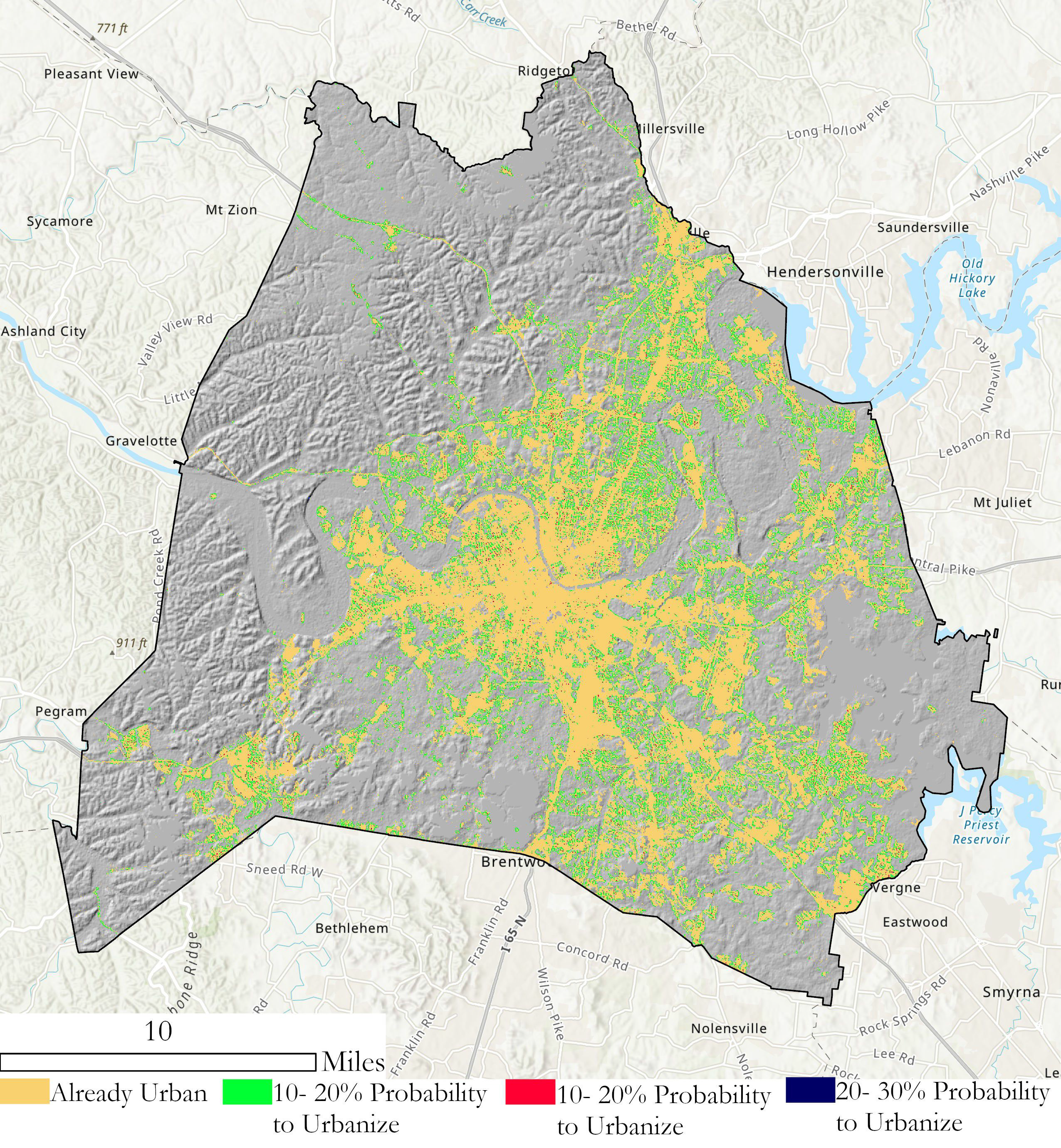
Linehan’s graduate research focused on studying future urban sprawl in the metropolitan area of Nashville, Tennessee (Davidson County). As part of this work, she applied the SLEUTH (Slope, Land cover, Exclusion, Urban growth, Transport and Hill shade) Model which utilizes several commonly accessible geospatial datasets including
USGS Shuttle Radar Topography Mission (SRTM), National Land Cover Database (NLCD), U.S. Census Bureau road files, and Digital Elevation Models. Additional geospatial data was added from local sources.
Developed by Dr. Keith C. Clarke at UC-Santa Barbara, SLEUTH is categorized as a “cellular automata (CA) model” and is open source and available for download. It models urban growth based on cells (5km x 5km, 30m x 30m, etc.) which support the geographic unit of analysis. The model suggests that changes in the geographic construct of any specific cell normally mimics and is a result of similar changes in neighboring cells. Clarke was faculty at Hunter College in NYC 1982-1986.
Historical imagery and vector data of the datasets identified above of Davidson County for 2001, 2006, 2011, and 2016 were collected and used to calibrate the SLEUTH model to simulate urban growth for the period of 2017-2040. The urban area for 2016 was 119.81 square miles and from the SLEUTH model is said to increase to 121.90 square miles for 2040. The urbanization rate during the historical time period (2001-2016) is 11.11% but the SLEUTH model predicts a much slower urbanization rate during the simulated time period (2017-2040) of 1.59%. This study shows the SLEUTH model can be beneficial in modeling future urban growth but also suggests a need to model more accurately development within intra-urban areas as well as vertical urbanization within already densely urban regions. Here is a great 10-minute YouTube presentation describing the study and for those interested in more detailed information, here is a copy of Linehan’s thesis.

While the population of Nashville and Davidson County is expected to grow over the next 20 years, most of the growth is anticipated in already developed areas minimizing urban sprawl.
Selected Additional Geospatial Projects:
New Yorkers for Parks
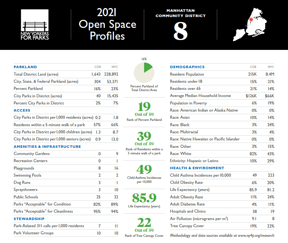
As an intern for the New Yorkers for Parks, Linehan created Open Space Profiles on parks and open space citywide, broken down by each NYC community board district. From open space quality and access to demographic and health information, the Profiles offer a summary for all 59 NYC community districts. This product enables elected officials, candidates, and community groups alike can use to better understand and convey open space issues in their communities.

Many interesting facts are presented in the profiles. For example, 33% of New Yorkers do not have a park within a five minute walk and 48 of 59 districts have less than 10 percent of city-owned parkland within their district. More data can be found here.
Best Places to Breath in New York City
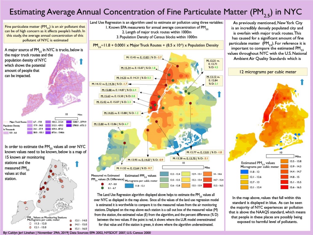
That map for the land use regression having to do with PM2.5 (particulate matter) concentrations in NYC was done as a class assignment. The purpose of this map was that there is air monitors all over NYC. Using data air monitoring stations across New York City, Linehan used an ordinary least squares regression to test the associations between the dependent variable PM2.5 (particulate matter) measurements and the independent variables (major truck routes and population density). The result from this regression was estimated PM2.5 data which was used to interpolate a surface which shows the estimated PM2.5 values across NYC. The map in the lower right shows that the suggested and safe PM2.5 values is 12 micrograms per cubic meter according to the U.S. National Ambient Air Quality Standards. Only isolated locations in south Brooklyn and Queens and a few areas in Staten Island actually have an acceptable PM2.5 value according to this study. Data used in the study was from U.S. EPA, New York State DOT and U.S.Census.

With the focus on using data from citywide air monitoring stations, Linehan’s project identified only a select number of areas across the city that met acceptable air quality standards. This poster can be downloaded here.
Accessibility and Connectivity of Bike Paths in the Bronx, New York
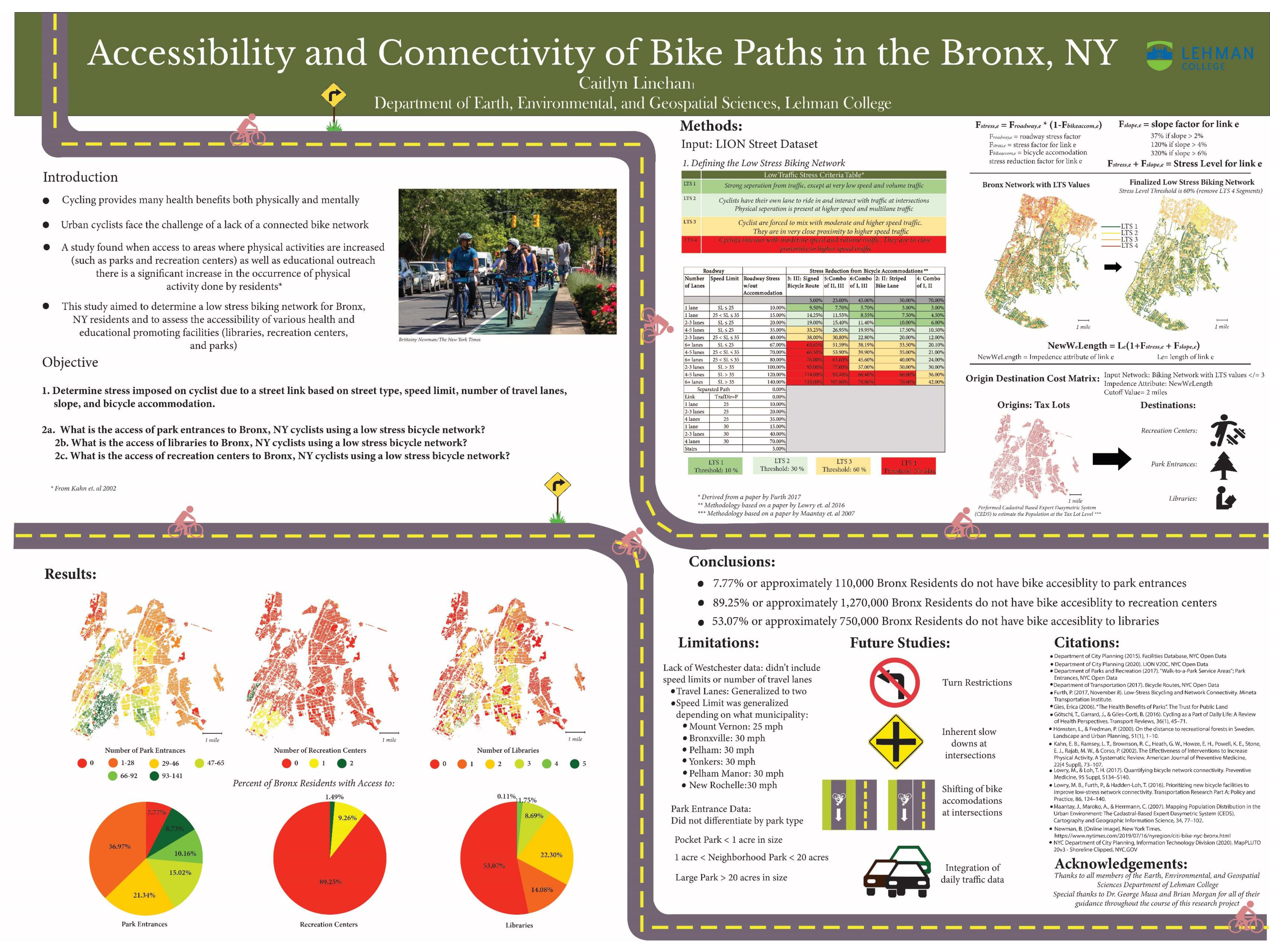
Another one of Linehan’s class projects focused on applying a network analysis on the accessibility of a low stress bike network in the Bronx to access select facilities which promote well being such as parks, recreation centers, and libraries. It is well established people that engage in physical activity can greatly reduce the risk of different diseases as well as reducing stress and anxiety. To this end, biking is a great form of physical activity that provides these benefits though a deterrent to urban biking in areas such as the Bronx, is a lack of a connected bike path.
Her findings, which are included in the poster below, finds that though only a small proportion of Bronx residents do not have access to a park entrance via a bike portal, it is estimated a disproportional percent (89%) do not have access to recreational centers and 53% lacking bike access to libraries. Central to the analysis is applying “Level of Traffic Stress” (LTS) coefficients to each road segment. A copy of the poster below can be downloaded here.

Safe and readily available bike networks are important factors in providing access to urban cultural and community facilities. This poster can be downloaded here.
Summary:
The Lehman GISc Program emphasizes “real-world” applications of geotechnologies and geospatial analysis to solve problems and improve conditions focusing on New York City as a “living laboratory.” The program continues to grow and providing trained and well educated graduates to organizations and governments across the metropolitan area.
Linehan will be continuing her graduate education by beginning her doctoral work at the University of California – Santa Barbara which was one of the original three universities associated with the The National Center for Geographic Information and Analysis (NCGIA). Formed in 1988, NCGIA also includes the University of Buffalo and the University of Maine.
Contact:
Caitlyn Jeri Linehan
Graduate Student
Lehman College, City University of New York (CUNY)
Department of Earth, Environmental, and Geospatial Sciences
CAITLYN.LINEHAN@lc.cuny.edu
CaitlynLinehan@ucsb.edu
Dr. Yuri Gorokhovich
Associate Professor
Lehman College, City University of New York (CUNY)
Department of Earth, Environmental, and Geospatial Sciences
yuri.gorokhovich@lehman.cuny.edu
