A few weeks ago, Linda Rockwell (Mohawk Valley GIS) posted to the GISNY listserv making reference to a short conversation she recently had with an elected federal representative. As it turns out, the representative she was talking with did not know what “GIS” or Geographic Information Systems stood for even though he was active on committees in Washington dealing with Transportation and STEM issues. For those of us who have been working in GIS in New York State for many years, Linda’s encounter does not come as a surprise. By no means was it the first time, nor will it be the last, a GIS practitioner in New York State came away from a conversation scratching his or her head thinking “How can that politician possibly not know what GIS is about or the value of what we do?!” Reason: one of our most significant limitations as a statewide community of GIS professionals is that we have been incredibly slow in terms of delivering an effective and lasting “message” to elected officials concerning the role of geospatial technology in government and business. While there are pockets of successful GIS projects across the state, due largely on local and sustaining political support, widespread legislative awareness of the technology has never been truly realized.
So What’s Missing?
In context of advancing as a professional discipline, look no further than similar organizations across the state as part of their efforts in representing membership and professional interests to elected officials. And really, no Madison Avenue magic is involved – just very specific outreach and polished marketing to the Legislature as part of creating legislative agendas. For example, current efforts by NYS professional organizations which benefit from the development of geospatial technology include:
- New York State Society of Professional Engineers: Always at the top of my list here in Westchester County. Their influence is broad and at the end of the day their involvement and use of geospatial data is endless. And they always host great golf tournaments.
- New York State Association of Chiefs of Police: Many years ago as a rookie GIS Manager I was told by a superior that when justifying or pitching a GIS budget I should always have the Police and Fire Chief standing next me. Some of the best guidance I ever received which still resonates today. We’ve spent many years carefully nurturing our relationships with these disciplines which have proven to be incredibly fruitful.
- New York State County Highway Superintendents Association: What a winter for roads across the region. One of the few places where grant funding is still to be found, transportation networks are a staple for GIS programs statewide supporting many emerging geospatial applications in vehicle tracking, mobile mapping, inspections and work order/permit processing. Transportation and public works departments make great GIS allies. Take note of their annual legislative approach: membership showing up in mass in Albany and then head to the chambers to see their representatives. If there is some kind of YouTube video of this annual event, it would make a great training video for the NY GIS Association.
- New York State School Board Association: I’m still at a loss as to why after so many of GIS development across state the GIS/geospatial community has not aligned itself closer to our public school systems. Particularly at the local level where we are competing for the same tax dollar and there are so many areas of mutual interest including demographic analysis, demographic analysis, facilities management and public safety programs, and student transportation applications among others. And this has nothing to do with GIS in the classroom which is still a work in progress at best. You can be assured the Legislature will hear the NYSSBA 2014 legislative agenda loud and clear.
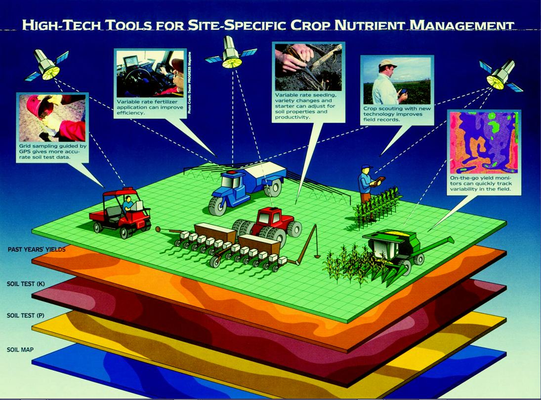
- New York Farm Bureau: I’ve recently written on the growing number of areas in the agricultural space where the traditional GIS community can expand collaborative efforts. The NYFB legislative priorities augment the recently passed federal farm bill (The Agriculture Act of 2014) which authorizes agricultural, environmental and community assistance programs through the end of fiscal year 2018 and contains provisions that support infrastructure and the environment. I bet the NYS GIS community can find a way to get involved.
- New York State Association of Professional Land Surveyors: While their website is a bit out of date in context of 2013/2014 information, NYAPLS is no stranger to the NYS GIS community based on the many years of debate over the “Surveyor Legislation” which as of January 2014 is in Legislative committee review. With an organization of comparable membership numbers to the NY GIS Association, NYAPLS seems to a decent job in getting its message heard and represented.
- Even umbrella organizations such as New York State Association of Counties, New York Conference of Mayors and Municipal Officials, and even the Business Council of New York have broad legislative agendas representing government and business interests involved in geospatial technologies such as economic development, tourism, health, infrastructure, and the environment.
Noted, most of these organizations have been established much longer, are vastly better funded, and are represented by legal counsel and supported by lobbyists. Though the Legislative Committee of the NYS GIS Association has been closely monitoring evolution the “Surveyor Legislation” over the past couple years, the NYS GIS professional community can learn much from the inner-workings of these organizations on how to build effective legislative agenda programs.
Is There Any Relevant NYS 2014 GIS Legislation?
Kinda. Maybe a little by accident and a little by design. Ironically in stark contrast to Linda’s concern that elected officials don’t really know about GIS and its still “our secret”, there actually is legislation currently under review in the NYS Legislature which has either specific mapping language or relies to some degree on geospatial technology. Speaking as one who was a member of the New York State GIS Coordinating Body for 17 years (now dba as the GIS Advisory Council) and having routinely attended state conferences and hosted local user group meetings, I can say there has been very little dialog, communication, and/or review of NYS legislative bills by the GIS community – except for the “Surveyor Legislation”. I doubt much of the NYS GIS community knows little of how these pieces of legislation were submitted, by whom, when, or why. In showing what is currently on the table, I simply used the online NYS Open Senate legislative search engine using key words such as “mapping, geographic information systems, and surveying” to generate a list. Some of the proposed bills are more relevant than others and/or have been around a while, but at least the search result can and should be part of the discussion. Illustrative pieces of legislation aligned with the NYS geospatial disciplines include:
- Surveyor Legislation: As noted above – this one is still around. The NYGIS Association has been tracking and reviewing this piece of legislation for several years primarily with regard to its potential impact on field data collection/mapping with GPS units and the mapping of physical features.
- Open Data Law: One of my favorites in context of all discussions and efforts we’ve been hearing relative to “open government” here in NYS. Not clear how this does/does not augment the Governor’s Executive Order of last year or relates to Open New York – which was actually launched through the efforts of NYS Dept. of Health. And there are a bunch of new geospatial open data portals to choose from as well.
- Legislation relating to public health issues including Autism and Alzheimer‘s detection (see also Bill A5025-2013) and ovarian and breast cancer research (the later of which signed into law).
- Proposed legislation to establish both a statewide planning and mapping system of educational institutions and for the development of a comprehensive campus security plan for the state university of New York, the city university of New York and community colleges.
- Miscellaneous legislation directing the commissioner of agriculture and markets to assess and report on the use and development of precision agriculture, and the use of broadband by farmers. NYS agricultural GIS ready to go prime time.
- Also, efforts to create a website providing sex offender registry information to be searchable by zip code of a registrant’s employment and a framework to provide notice of proposed construction of gas gathering lines and pipeline facilities for the purpose of creating and maintaining a map of infrastructure related to fuel gas transmission, as well as health and environmental legislation focusing on hydraulic-fracking.
Conclusions
While I can relate to the conversation Ms. Rockwell had with her representative, I’d rather propose that our underappreciated “little secret” of GIS is still not a priority in context of the many critical issues elected officials are faced with today, particularly in an era of declining staff and financial resources. Come budget time, the “must-have” case just hasn’t been made in many circles. We haven’t elevated the collective body of geospatial work to a high enough level of sustained and ongoing political awareness. And it’s not going to change until the GIS community transforms the manner in which it presents the geospatial message on a much larger stage and can build capacity to conduct business within the legislative framework.