MGRS Mapper: Software for Military Operations Mapping

Program built and designed by Rochester area New York Army National Guard member

While serving in a Joint Multinational Training Group in Ukraine (JMTG-U) in 2018 along with other NATO nation soldiers, New York Army National Guard CPT James Pistell, a Rochester resident, was using a website to make operations graphics as they planned training operations while training Ukrainian soldiers and battle staffs. A self-taught software web developer in civilian life, Pistell felt the website was outdated, had limited functionality, and believed he could build a much better version based on his military in-field service and programming skills.

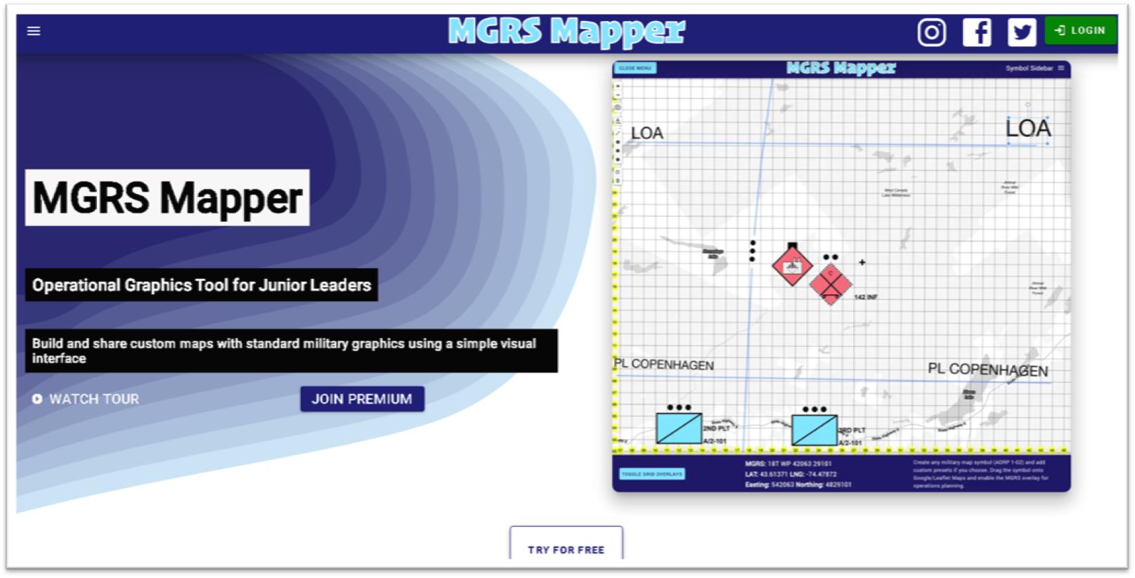
Pistell makes available both free and subscription-based versions of MGRS-Mapper. The web site landing page provides access to the free version enabling site visitors to see samples of the military symbology and easy-to-use drag and drop functionality

Upon his return to the states,  leaving his full-time job in marketing and dedicating over a year of full-time development work,  Pistell released MGRS-Mapper (MGRS for Military Grid Reference System) in late 2018.  (The MGRS overlay is based on standard Grid Zone Designator intervals commonly found on military installation maps using the NAD 83/WGS 84 industry standard).  

Developed entirely with JavaScript the application enables users to easily overlay the MGRS grid atop of a Google base map (other base maps are available as well) and provides Premium users access to the latest standard in military symbols as part of  ADP 1-02 (Army Doctrine Publication) which contains over 737 unique symbols used by many branches of the military. This set includes all Land Forces, Equipment, Activities, Graphic Control Measures, Tactical Mission Tasks, Installations, Supplies, Command Posts, Civilian Authorities, Sea Units, Air Units and Sustainment.  Definitely not the same symbol sets the GIS community is accustomed to using in making land use and environmental maps albeit interesting nonetheless!

Premium Version

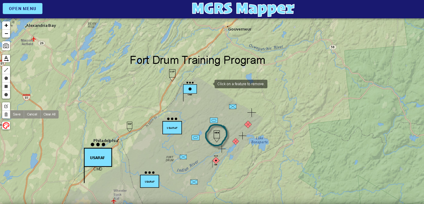
With access to the premium version I was able to build, if only an introductory amateur version at best, a CONOP (Concept of Operation) map.  Using symbols compliant with ADP 1-02, I’ve mapped out a National Guard training program in the area of Ft. Drum showing the locations of friendly (blue symbology) platoons and infantry, armored tank units, and field artillery. Red colored symbols, or hostile resources, identifying the locations of infantry and artillery units. Also included in the map show the locations target reference points (black crosses), check points on the western edge of Ft. Drum along Route 11 and a larger blue symbol in the southwestern part of the map to highlight a National Guard Command Post.  The symbol circled in green in the middle of the map is an Amnesty Point. Hundreds of other military symbols are available for the user.

The horizontal toolbar on the left side of the application provides the user with the capabilities of taking a screen snapshot (camera icon) and saving as a .png to be downloaded and emailed to another user, printed out as a handout, or embedded in slides.

Users can click on any symbol on the map and drag it to your preferred location. From there you can rotate, resize, invert, scale up or scale the symbol down.

Pistell is currently working on several enhancements to the application including allowing Premium mobile users to cache maps on their device for use in places with limited internet connection, porting the application for use on both Apple iOS and Android devices, and the ability to share live links of user maps for live map scenario collaboration.  MGRS Mapper also offers certain organizations a large discount on team accounts including Volunteer Search and Rescue Teams, Volunteer Fire Departments, ROTC Battalions, U.S. Military elements at section level or above, as well as any  organization that relies primarily on volunteers.

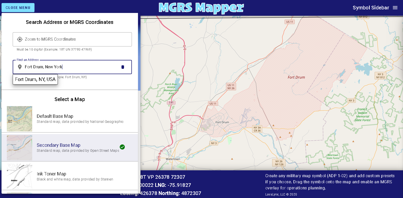
MGRS Mapper allows users to find locations by either typing in an address or inputting a valid MGRS grid coordinate as well offering several easily accessible and open source base maps including OpenStreetMaps (shown below), National Geographic, ArcGIS, Stamen (black & white) and OpenStreetMap.

Pistell notes he has about 225 active subscriptions with many in military (Army).  He also includes on the list the Panamanian National Guard, Californai Search and Rescue Team, and numerous civilians who are military trainers.  “It’s incredibly rewarding to see individuals and organizations using a software program that you’ve written all the code for and built from scratch”, he says.  Continuing he notes “ this all started with my experience overseas and wanting military leaders and colleagues to make training maps and apply the same principals to organizations stateside.”

It would appear with the release of MGRS Mapper that Pistell is fulfilling that vision.

He currently serves as Cyber Network Defense Manager for the 173rd Cyber Protection Team in the New York Army National Guard.  

Contact:

CPT James Pistell
MGRS-Mapper
admin@mgrs-mapper.com

Geospatial Business Spotlight: Adirondack Research

Location:                      Saranac Lake, New York

Website:                       https://www.adkres.org

Employees:                  3 Full-Time / 6 Seasonal

Established:                 2012

The Company

Adirondack Research is a small business located in Saranac Lake which focuses on building expert-backed and science based geospatial solutions.  Currently the firm’s primary focus is on applications and work involving invasive species, climate change, and socio-economics.  Adirondack Research staff includes GIS specialists, web developers, and field technicians and the company produces a retail line of recreation and way-finding maps under the brand Green Goat Maps.

Geospatial software used inside the company  includes ArcGIS Pro on the desktop and ArcGIS Online for a variety of web maps and viewers.  Field data collection is also supported by ESRI tools including Collector and Survey123.  For hardcopy map production both, Adobe Illustrator and Adobe InDesign are used.

Adirondack Research’s Director is Ezra Schwartzberg who received his undergraduate degree from SUNY College of Environmental Science and Forestry (ESF),  graduate degree from University of Kentucky, a doctorate in Entomology  from Penn State and additional post-doctorate work at the University of Wisconsin.

To date,  Adirondack Research clients include the U.S. Forest Service, Adirondack Council, Lake Placid Land Conservancy, Food and Agriculture Organization of the United Nations, U.S. Department of Agriculture, ADK Action, the New York State Department of Environmental Conservation which it has contracted for several invasive species projects, and others.   While most of Adirondack Research’s work is focused in New York State and across New England, their work has taken the firm to Lebanon as well as assisting to the development of a science curriculum for elementary schools in China.

Geospatial Products and Services

  • Environmental mapping using geographic information systems (GIS)
  • Biological inventories
  • Field experiment logistics
  • Ecosystem services assessment
  • Long-term ecosystem monitoring
  • Invasive pest management planning and analysis
  • Comprehensive management plans
  • Public outreach and stakeholder engagement
  • Citizen science
  • Grant writing
  • Expert witness testimony

Schwartzberg uses research expertise to guide processes, including program design, data analysis and project evaluation.  By combining ecological research with print and digital media, Adirondack Research is able to communicate science to help our clients reach their policy goals.

Illustrative projects include:

Surveying Adirondack Lakes for Invasive Species

Over the past several summer field seasons of 2018 – 2020, Adirondack Research was contracted by the Nature Conservancy’s Adirondack Park Invasive Plant Program (APIPP) to survey lakes throughout the Adirondacks.  Data collected during these surveys was used to produce individualized lake maps of aquatic invasive species (AIS) distribution. Objectives for these efforts were twofold:

  1. Detect and delineate any new or existing invasive plant or animal infestations within prioritized lakes.
  2. Utilize a Lowrance ELITE-7Ti fishfinder to map the vegetation beds, contour lines and bottom substrate hardness of a select set of those lakes as a way to gather important data on plant distribution and other physical parameters that influence aquatic plant invasion.

In 2018, Courtney Pond in Essex County was the first year this pond was surveyed and no AIS  detected.

Mapping invasive plant beds is accomplished using a suite of software and hardware tools including GPS, sonar detecting units, C-Map by BioBase, and ArcGIS Pro.  Data from sonar units such as Lawrance Fishfinders can be translated using third party software platforms, including C-Map BioBase and ReefMaster into a format which can be interpolated with ArcGIS Pro to create visualizations of the lake bottom.  This enables staff to assess exactly where an AIS infestation is located within a larger bed of native plants and useful overtime to monitor AIS beds and their spread.  Raster layers generated as part of the work flow are then used to generate maps in ArcGIS Pro and Adobe Illustrator for final reports.  The 2019 report is complete with maps of all lakes or ponds surveyed and can be downloaded here.

Additional information on this and similar Adirondack Research invasive species projects, visit this page.

Lake Placid & Saranac Lake Winter Trails Map

While Adirondack Research makes maps for a variety of purposes to support  geospatial analysis,  ecological species distributions and for land acquisition and conservation easements, the firm also produces a line of recreation and way-finding maps under the brand Green Goat Maps.

As part of this effort, Green Goat Maps emphasizes responsible recreation and environmental stewardship by partnering with organizations to promote principles like Leave No Trace.  Maps also make reference to the proper etiquette for publicly accessible trails, how to prevent the spread of invasive species, and information and regulations specific to the areas covered in each map. Green Goat Maps has  partnered with organizations such as Barkeater Trails Alliance, the Adirondack Land Trust, and The Nature Conservancy Adirondacks in these efforts.

One example of a Green Goat map is the region’s “go-to” map for winter recreation – The Lake Placid and Saranac Lake Winter Trails Map  – which offers all of the area cross country ski, snowshoe and fat bike trails in one document.  The map highlights the Jackrabbit Ski Trail and covers ski trails from Paul Smiths to Wilmington including the popular Hayes Brook Truck Trail, Deer Pond Trails, Moose Pond Trail, Brewster Peninsula Trails, Henry’s Woods, Heaven Hill and more.  The map also includes commercial ski centers, including the Paul Smith’s College VIC, Dewey Mountain Recreation Center, Cascade X-C Ski Center and Mt. Van Hoevenberg.  For the Winter Trails Map, Adirondack Research also added trails on private and municipal land with permissions well as adding gates and parking areas which were mapped from ground research. The top banner on each map inset also shows info about what activities people can do on each individual trail network

Additionally, Green Goat gives 1% back on the sale of its maps to nonprofits through 1% for the Planet.

For more  information on this and similar Green Goat Maps products, visit this page.

Mapping Broadband Infrastructure for Essex County

A current project Adirondack Research is working on is with Essex County (as well as four other counties) and local community leaders towards designing and implementing web mapping  visualization tools which will help support and guide expanded broadband installation across the County.   These easy-to-use geospatial tools are intended to be used by local officials in multiple governments to pinpoint gaps in infrastructure coverage. Other aspects of the project include mapping the boundaries of current broadband contracts with providers across the County, checking and verifying property addresses, and performing quality assurance on plan of record build-outs.

Broadband is only available is specific areas of Essex County. Mapping at the street level by Adirondack Research will enable government officials to work with broadband providers to expand coverage.

Contact:

Ezra Schwartzberg, PhD
Adirondack Research
73 Church St
Saranac Lake, NY 12983
www.akdres.org