
Location: Saranac Lake, New York
Website: https://www.adkres.org
Employees: 3 Full-Time / 6 Seasonal
Established: 2012
The Company
 Adirondack Research is a small business located in Saranac Lake which focuses on building expert-backed and science based geospatial solutions. Currently the firm’s primary focus is on applications and work involving invasive species, climate change, and socio-economics. Adirondack Research staff includes GIS specialists, web developers, and field technicians and the company produces a retail line of recreation and way-finding maps under the brand Green Goat Maps.
Geospatial software used inside the company includes ArcGIS Pro on the desktop and ArcGIS Online for a variety of web maps and viewers. Field data collection is also supported by ESRI tools including Collector and Survey123. For hardcopy map production both, Adobe Illustrator and Adobe InDesign are used.
Adirondack Research’s Director is Ezra Schwartzberg who received his undergraduate degree from SUNY College of Environmental Science and Forestry (ESF), graduate degree from University of Kentucky, a doctorate in Entomology from Penn State and additional post-doctorate work at the University of Wisconsin.
To date, Adirondack Research clients include the U.S. Forest Service, Adirondack Council, Lake Placid Land Conservancy, Food and Agriculture Organization of the United Nations, U.S. Department of Agriculture, ADK Action, the New York State Department of Environmental Conservation which it has contracted for several invasive species projects, and others. While most of Adirondack Research’s work is focused in New York State and across New England, their work has taken the firm to Lebanon as well as assisting to the development of a science curriculum for elementary schools in China.
Geospatial Products and Services
- Environmental mapping using geographic information systems (GIS)
- Biological inventories
- Field experiment logistics
- Ecosystem services assessment
- Long-term ecosystem monitoring
- Invasive pest management planning and analysis
- Comprehensive management plans
- Public outreach and stakeholder engagement
- Citizen science
- Grant writing
- Expert witness testimony
Schwartzberg uses research expertise to guide processes, including program design, data analysis and project evaluation. By combining ecological research with print and digital media, Adirondack Research is able to communicate science to help our clients reach their policy goals.
Illustrative projects include:
Surveying Adirondack Lakes for Invasive Species
Over the past several summer field seasons of 2018 – 2020, Adirondack Research was contracted by the Nature Conservancy’s Adirondack Park Invasive Plant Program (APIPP) to survey lakes throughout the Adirondacks. Data collected during these surveys was used to produce individualized lake maps of aquatic invasive species (AIS) distribution. Objectives for these efforts were twofold:
- Detect and delineate any new or existing invasive plant or animal infestations within prioritized lakes.
- Utilize a Lowrance ELITE-7Ti fishfinder to map the vegetation beds, contour lines and bottom substrate hardness of a select set of those lakes as a way to gather important data on plant distribution and other physical parameters that influence aquatic plant invasion.
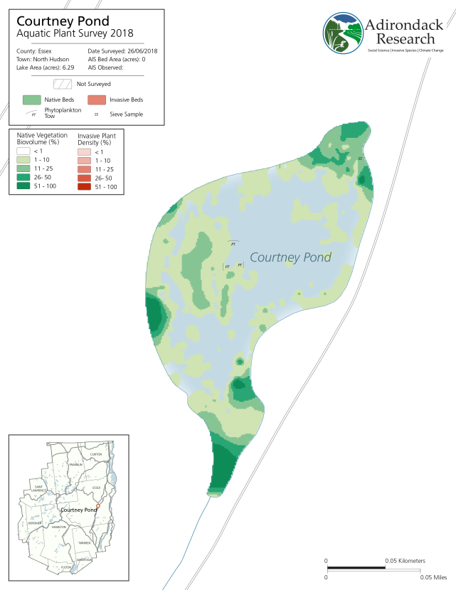
In 2018, Courtney Pond in Essex County was the first year this pond was surveyed and no AIS detected.
Mapping invasive plant beds is accomplished using a suite of software and hardware tools including GPS, sonar detecting units, C-Map by BioBase, and ArcGIS Pro. Data from sonar units such as Lawrance Fishfinders can be translated using third party software platforms, including C-Map BioBase and ReefMaster into a format which can be interpolated with ArcGIS Pro to create visualizations of the lake bottom. This enables staff to assess exactly where an AIS infestation is located within a larger bed of native plants and useful overtime to monitor AIS beds and their spread. Raster layers generated as part of the work flow are then used to generate maps in ArcGIS Pro and Adobe Illustrator for final reports. The 2019 report is complete with maps of all lakes or ponds surveyed and can be downloaded here.
Additional information on this and similar Adirondack Research invasive species projects, visit this page.
Lake Placid & Saranac Lake Winter Trails Map
 While Adirondack Research makes maps for a variety of purposes to support geospatial analysis, ecological species distributions and for land acquisition and conservation easements, the firm also produces a line of recreation and way-finding maps under the brand Green Goat Maps.
As part of this effort, Green Goat Maps emphasizes responsible recreation and environmental stewardship by partnering with organizations to promote principles like Leave No Trace. Maps also make reference to the proper etiquette for publicly accessible trails, how to prevent the spread of invasive species, and information and regulations specific to the areas covered in each map. Green Goat Maps has partnered with organizations such as Barkeater Trails Alliance, the Adirondack Land Trust, and The Nature Conservancy Adirondacks in these efforts.
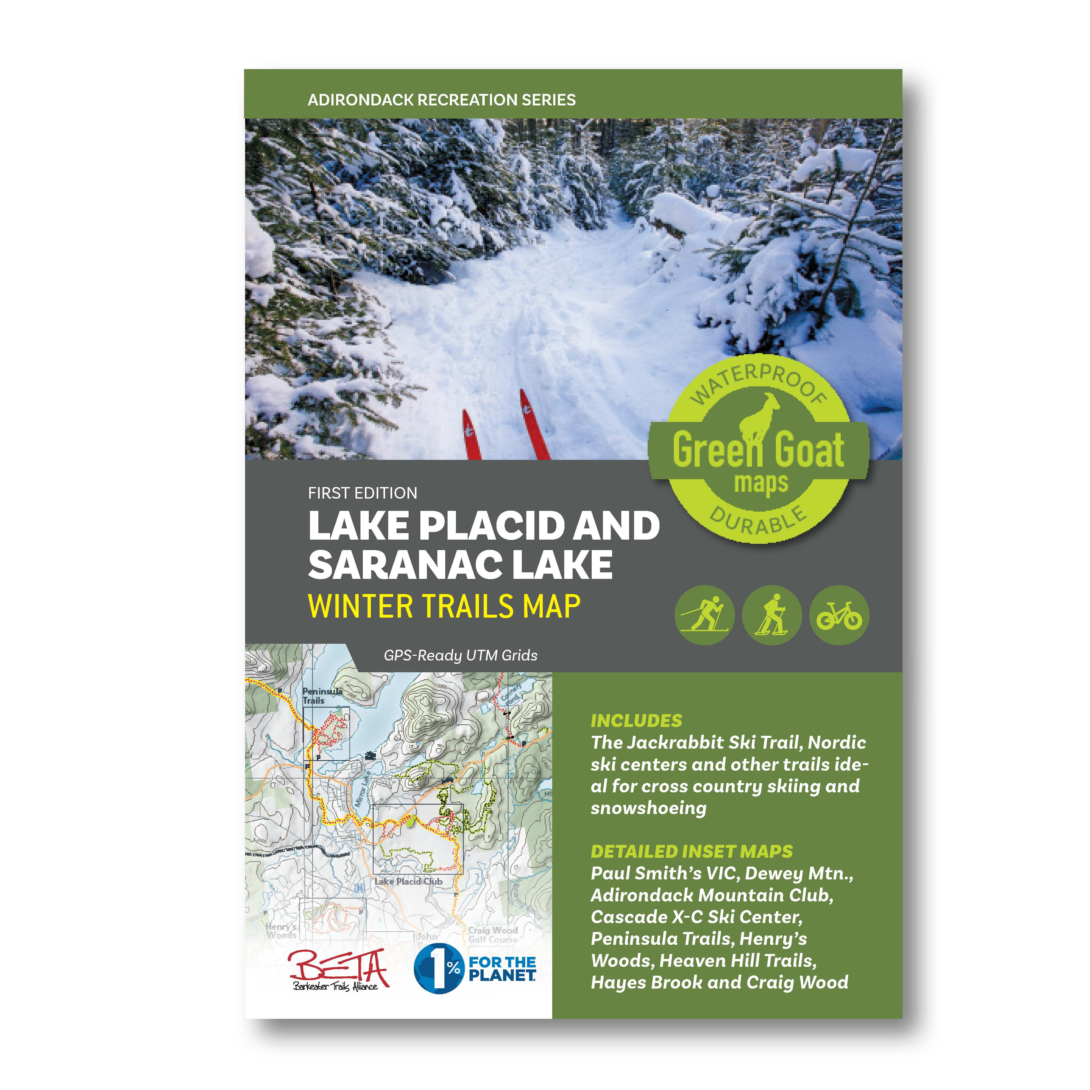 One example of a Green Goat map is the region’s “go-to” map for winter recreation – The Lake Placid and Saranac Lake Winter Trails Map – which offers all of the area cross country ski, snowshoe and fat bike trails in one document. The map highlights the Jackrabbit Ski Trail and covers ski trails from Paul Smiths to Wilmington including the popular Hayes Brook Truck Trail, Deer Pond Trails, Moose Pond Trail, Brewster Peninsula Trails, Henry’s Woods, Heaven Hill and more. The map also includes commercial ski centers, including the Paul Smith’s College VIC, Dewey Mountain Recreation Center, Cascade X-C Ski Center and Mt. Van Hoevenberg. For the Winter Trails Map, Adirondack Research also added trails on private and municipal land with permissions well as adding gates and parking areas which were mapped from ground research. The top banner on each map inset also shows info about what activities people can do on each individual trail network
Additionally, Green Goat gives 1% back on the sale of its maps to nonprofits through 1% for the Planet.
For more information on this and similar Green Goat Maps products, visit this page.
Mapping Broadband Infrastructure for Essex County
A current project Adirondack Research is working on is with Essex County (as well as four other counties) and local community leaders towards designing and implementing web mapping visualization tools which will help support and guide expanded broadband installation across the County. These easy-to-use geospatial tools are intended to be used by local officials in multiple governments to pinpoint gaps in infrastructure coverage. Other aspects of the project include mapping the boundaries of current broadband contracts with providers across the County, checking and verifying property addresses, and performing quality assurance on plan of record build-outs.
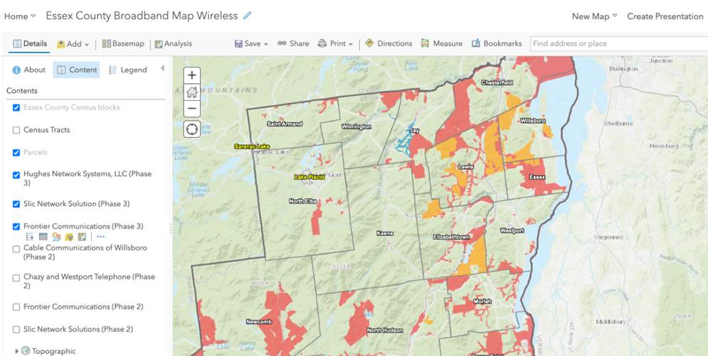
Broadband is only available is specific areas of Essex County. Mapping at the street level by Adirondack Research will enable government officials to work with broadband providers to expand coverage.
Contact:
Ezra Schwartzberg, PhD
Adirondack Research
73 Church St
Saranac Lake, NY 12983
www.akdres.org