From a government perspective, GIS data sharing – or even information sharing – with utilities (gas, water, electric, telecommunications) in New York State has always been challenging. Utilities have historically been wary of sharing asset data fearing the information would then be later redistributed by governments due to their obligations under the New York State Freedom of Information Law (FOIL). Redistribution and the improper use of critical utility asset data obviously provides a myriad of potential public safety issues as well as possibly compromising the utility’s competitive position among neighboring counterparts. While there are rare exceptions, it is most common to find thematic maps of utility service areas available for download (ex. Kentucky, Ohio, California, Wisconsin, and Michigan) in hardcopy format only. Typically these maps are available in PDF format, designed at a small scale (1:24,000) and do not show site specific or parcel level detail. While these examples show the utilities willingness to share geospatial information with government and public, it falls short in context of being able to use such data in GIS programs for mapping and viewing at the street level. A very limited number of New York State utility related GIS files are available from the NYS GIS Clearinghouse albeit these datasets are at a very small scale and several years old. Data for other New York State regulated utilities can be found at the New York State Public Service Commission website.
But here in New York State, we may be witnessing the start of a significant change in how utilities share and exchange information on their assets with governments, particularly in the aftermath of significant events such as Hurricane Sandy. Taking a post-Sandy directive from the New York State Public Service Commission to “improve internal storm damage assessment collection and collaboration with municipal entities to improve future restoration efforts” New York State Electric and Gas (NYSEG) has recently prototyped a basic “damage assessment” application with two municipalities – the Towns of Lewisboro and Pound Ridge – in Westchester County focusing on issues associated with NYSEG utility poles and road closures. NYSEG is currently in discussions with the Town of Bedford as well. Data collected “from the field” immediately after a significant event is intended to improve NYSEG operation centers to better allocate and dispatch resources to areas of greatest need. Conversely the status of NYSEG pole data can be viewed by local government administrators and emergency operations staff to help facilitate assistance at the local and neighborhood levels.
Application Components
NYSEG built the application using the ESRI Collector app on Mini iPads. (Note: This was an internal NYSEG business decision as the app can be deployed on both Androids and iPhones as well). In addition to collecting data through the mobile device, the same feature service can be accessed utilizing a standard browser on a personal computer for the entry of called-in damages. The feature service, which is being published by NYSEG, contains company X,Y utility pole location data combined with other local large scale data sets (planimetrics) to provide additional reference and context.

Version 1.0 of the NYSEG field data collection is designed to collect basic location information on road closures, utility pole issues, and related tree conditions information. This image highlights data collection in a pilot project in southeastern New York State.
Wireless connectivity is not an issue as the Collector app is used in disconnected mode so it can be used in wireless dead zones. Data collected on the devices while in the disconnect mode is later synchronized with NYSEG servers by the user when wireless connectivity is available. Access to the application – whether it is on a mobile device or on the desktop – is through a password protected login to ensure data is being collected by authorized users at the local level. For the time being NYSEG anticipates activating the program only in major outage events and is continuing its outreach with local government Emergency Operations programs to expand the user base. Issues on local availability of mobile devices (smartphones, tablets, iPads, etc.) and required software to access the application through ArcGIS.com continue to be discussed with each municipality. As shown below, the application interface also includes an operational dashboard based on real time updates of damages submitted from the field. The associated graphs and easy to read maps provide important information for emergency response managers at the local level.
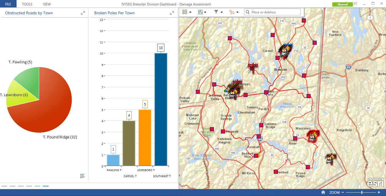
This NYSEG initiative presents a significant paradigm shift in the utility/government geospatial data sharing model and the benefits are already being recognized. Notes Town of Lewisboro Supervisor Peter Parsons “I am convinced this is a real step forward. NYSEG and we believe that if it had been operational during Hurricane Sandy we could have restored power two days earlier. Even if we are being overly optimistic, one day earlier would make it a real improvement.”
Other utilities across the Empire State – gas, water, electric, and telecommunications – might take note of similar geospatial technology opportunities to support information sharing with governments and community groups in times of similar need.
For more information, contact Stephen Hope, New York State Electric and Gas, at SJHope@nyseg.com.


