SAVI Builds a Metro NYC Presence

The last couple years I’ve been watching the growth of GeoNYC Meetup group and continue to be amazed at the far-reaching representation of individuals and companies now involved in the broad field we call “geospatial”.  One person shops, start-ups, open source/open data techies, apartment and loft based companies, strong business and private sector representation, community based mappers, and everything in-between.  A much different composition and representation than that of the other existing statewide geospatial/GIS communities and organizations that I and other colleagues of my GIS generation came through.   To date I have published three previous blog posts focusing on other contacts made through GeoNYC:  Mapzen, Mapillary and NiJel.

Spatial Analysis and Visualization Initiative (SAVI)

Also establishing a niche in the expanding geospatial space are community facing programs associated with and supported in academia environments.  One such program, which I was also introduced to through GeoNYC, is the  Spatial Analysis and Visualization Initiative (SAVI).  It was launched in 2013 and is at Pratt Institute.  SAVI is a GIS-based research lab and service center that focuses on mapping, data analysis, and visual storytelling, providing students, faculty, and community groups with the resources they need to communicate information in compelling ways. The first and only New York City college-based GIS lab open to community organizations and civic groups, SAVI offers computer access, technical assistance, professional training, workshops, and research that empower local organizations to create their own visions to improve the quality of life for their clients and constituents. At Pratt, SAVI supports students and faculty whose work reaches beyond the Institute’s campus to engage and benefit New York City.

Leading the SAVI program is Jessie Braden, who was appointed Director in the Fall of 2013.  Prior to SAVI, Braden spent three years at the Pratt Center for Community Development, a non-profit affiliated with Pratt Institute that provides technical services to community organizations.  She has also been an adjunct professor of GIS in Columbia University’s Graduate School of Architecture, Planning and Preservation Program since 2010.  Braden initially started SAVI with Pratt Programs for Sustainable Planning and Development (PSPD) Professor Juan Camilo Osorio as a volunteer side project in 2011 with the guidance of then Department Chair John Shapiro.  In addition to PSPD, Pratt Center and the Graduate Communications Design Department offered their official support, allowing the lab to come to fruition and solidifying SAVI’s focus on communities AND design.  Pratt Center also secured a $670,000 grant from NYC City Council to renovate a physical space on Pratt’s campus so SAVI can serve community organizations and students.  During the time the program was being institutionalized at Pratt, Osorio took a full-time position as Director of Research at the New York City Environmental Justice Alliance. Though not involved in day to day operations, Osorio remains a trusted advisor to SAVI.

SAVI consolidates the Institute’s GIS resources with an eye to social benefit. This means putting data analysis in the hands of community activists, students, and faculty. It also means making the products of GIS expertise visually legible and compelling so that the stories they tell will have as much impact as possible.

“At the end of the day, visual representation is as important as the quality of data analysis,” Braden observes. “Our vision for SAVI is to produce outstanding multidisciplinary projects  with the highest-caliber visual display— making the invisible visible, both inside and outside Pratt’s gates.”  Its Jessie’s belief, which I share,  that a well designed map should be able to stand on its own.  Such a product enables the reader to conduct the “spatial analysis” based on the distribution and rendering of the map data itself – with only minimal accompanying narrative to explain or describe the map.

Braden points to specific mapping projects which exemplify the SAVI cause:
Continue reading

NYS 2016 Geospatial Legislation: The Beat Goes On

Have been a little remiss in the blog content space of late and now trying to play catch up with a couple articles and stories in the works albeit nothing finalized.  With August typically being one of the slower months across the board, it’s always a good time to take a step back and see how the geospatial/GIS profession is growing across the state in context of making its presence known  or at least recognized and referenced in the legislative arena.   This year’s summary provides a little more fodder for discussion and content than in the past couple years – even to the point of dulling the urge to write in that very special way about one of my other favorite New York summertime geospatial topics:  The Geospatial Advisory Committee. The GAC.

State of the State

Always appropriate to start at the beginning of the year with the Governor’s State of the State “Built to Lead” themed speech (January 13th) which did offer some optimism – albeit indirectly – for investment and growth opportunities in geospatial technologies across the state.  Most notably with references in the areas of infrastructure development.  Even though many of the investments itemized in the speech are for major public facilities such as LaGuardia, the Jacob Javitz Center, and Penn Station – btw to the tune of $100 billion –  there is still room for enthusiasm in the GIS community hoping that even small portions of the $100 billion investment can trickle down to local government geospatial  programs to  support bridge and road management initiatives, public water/storm/sanitary systems rehabilitation projects, evolving resiliency projects, and many other infrastructure related efforts.  And best of all, providing funding opportunities for the many deserving GIS and civil engineering businesses which continue to support and help build statewide geospatial capacity. While it’s almost certain that the $100B funding is spread out over many appropriation bills, one can see the magnitude of the statewide infrastructure focus and priority by performing a keyword search on “infrastructure” in the New York State Bill Search form. Results? Fifty-seven bills match the search criteria.  Granted, not every bill is specific to geospatial & infrastructure – but it’s a damn good starting point for the statewide geospatial community.  And you can be well assured our brethren in the engineering, surveying, public works and aligned disciplines are already well engaged in tracking down the funding.  And btw, if you’re really interested and by comparison, do a similar search on keywords such as geospatial, mapping, geography, or GIS – and make note of the search results.  I’m by no means an expert in using the form, but by using it only casually, one can get a sense of the potential funding sources.

As in past State of State speech agendas, the governor makes reference to other should be GIS staple disciplines such as economic development (REDCs: Regional Economic Development Councils) and tourism – two very high level and visible government programs which the statewide GIS community has yet to make broad and sustaining inroads with.  Granted the current state administration’s REDC organizational chart is problematic in that these boundaries do not coincide with the existing NYS Association of Regional Councils boundaries, GIS-based economic development and tourism websites should continue to be a top priority for every county and/or regional planning commission across the state.

 2016 Bill Search

Certainly not an exhaustive list, but the following does provide a general flavor of the types of  geospatial/GIS-related bills which were either newly introduced or carried over from previous years.  Search results included:
Continue reading

Queensbury Geospatial: A Model for NYS Town Government GIS

Northbound New York State Northway Exit 20 leads to the Town of Queensbury which is the seat of Warren County.  With a 2010 population of 27,901 the town covers nearly 65-square miles including shoreline along Lake George and lands within the Adirondack Park.  Further into town, several of the usual NYS town government program offices are located at 742 Bay Road including staff and resources which support the town’s geographic information system (GIS).

GIS Background

Prior to 2002, Queensbury officials had worked with consultants to establish initial GIS capacity including the creation of ArcIMS applications and investing in multiple ESRI desktop licenses.  In 2002, the town’s GIS initiative changed significantly with the hiring of George Hilton.  Hired as a GIS Specialist and planner, George was brought onboard to build and advance the town’s  GIS program.

Prior to arriving in Queensbury, George had honed his GIS skills while a student at Central Connecticut State University and later in government positions  in the Denver and Kansas City areas as well as three years with Westchester County.  Now, 15-years after his arrival, George oversees a program which can be considered an exemplary NYS municipal government GIS program.

Current Queensbury Geospatial Products and Infrastructure        

George designs, codes and maintains the Town’s Interactive Mapper (Firefox and IE only) and a host of other ArcGIS.com map viewers including Fire and EMS, Planning and Zoning, and Phase II Stormwater Infrastructure.    He also supports emerging mobile mapping and data collection efforts which includes Trimble GPS units with Trimble Positions to collect data and update feature services and Geodatabases in the field.  The town also collects data (hydrant inspections, site inspections) with ArcGIS Collector using feature services and make maps available through ArcGIS Online.

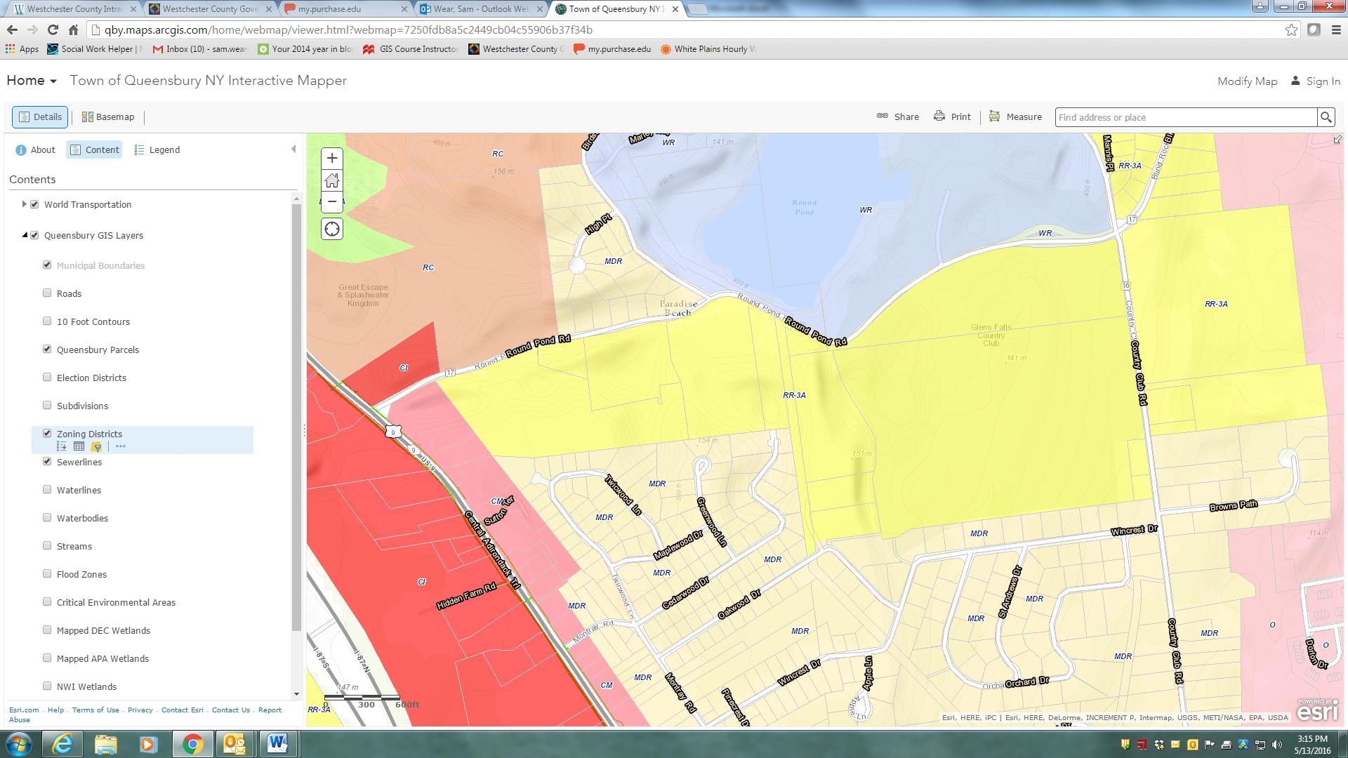
The Town of Queensbury Interactive Mapper includes many locally developed datasets as well as data from other authoritative sources including Warren County, NewYork State and the Adirondack Park Agency.

The Town of Queensbury Interactive Mapper includes many locally developed datasets as well as data from other authoritative sources including Warren County, NewYork State and the Adirondack Park Agency.

Other software components – much of which has been self-taught – George uses inlcludes Sybase (RPS) and SQL Server with ArcSDE as well as ArcGIS Server, ArcSDE, ArcGIS (Advanced), and Spatial Analyst.  The town is currently at ArcGIS Server 10.22 and are testing 10.4 with plans to upgrade very soon.  He also works with QGIS and Global Mapper from time to time.  Global Mapper has been particularly helpful in importing updated USGS topo quads (DRGs) in GeoPDF format into our GIS.

The Queensbury GIS program has grown from primarily providing support to the Planning Department to becoming a very important resource for many departments across town government.  Both the Town Board and Town Supervisor are very supportive of GIS and recognize how much of an important tool GIS has become to the Town.

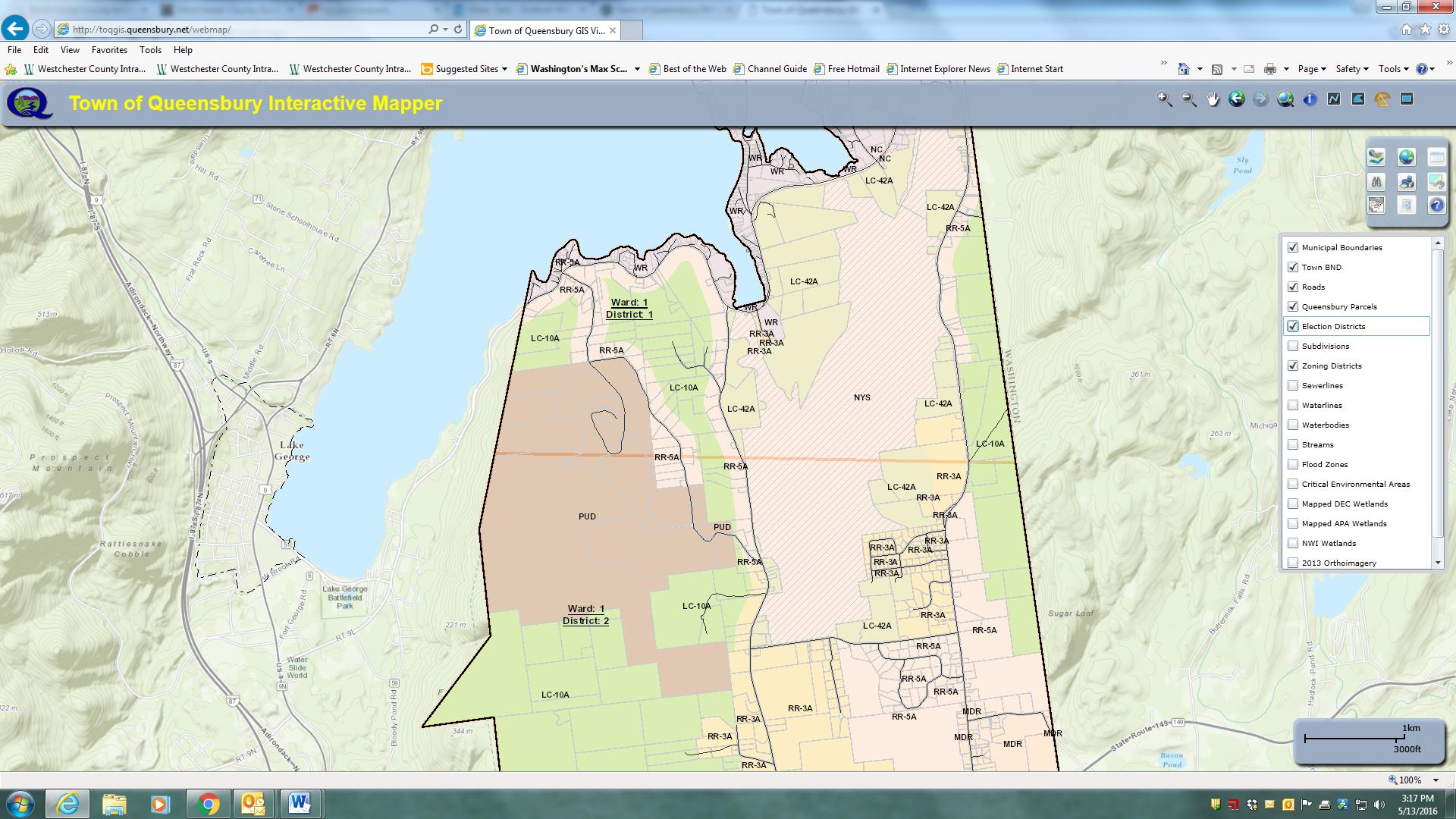
Parts of the Town of Queensbury is actually within the Adirondack Park and therefore subject to stringent land use regulations. This image highlights zoning districts on the southeastern shore of Lake George – within the park boundaries.

Parts of the Town of Queensbury is actually within the Adirondack Park and therefore subject to stringent land use regulations. This image highlights zoning districts on the southeastern shore of Lake George – within the park boundaries.

George maintains an excellent working relationship with Warren County GIS which is under the direction of Sara Frankenfeld where he obtains  parcel data.  The town creates town-wide datasets (zoning, subdivisions, hydrants, infrastructure, environmental, street centerlines, address points, etc) which are then shared back with the County. Referencing her ongoing GIS work with Queensbury, Sara explains:

“George is great to work with and especially in a rural environment where we don’t have any other full-time GIS staff within our respective local governments, it’s so helpful to have a colleague to bounce things off.  He’s a very good sounding board and when I’m considering starting a new project, I often call to get his thoughts.

 We’ve worked closely together on a number of projects.  We recently worked together to streamline the way e-911 addresses are assigned, and this has been a huge improvement to workflows in both of our offices, as well as in the Real Property office, the zoning/building inspectors departments, and the assessors’ offices

 Our current cooperative project is a NYS Archives LGRMIF grant funded project to make the SAM data, along with information about truss roofed structures (as required by a NYS law that went into effect 1/1/2015), and other relevant data such as hydrant locations, available to first responders via an Android/iOS app”.

George also works closely with several state agencies including the Adirondack Park Agency, NYS Parks and Historic Preservation, NYS Department of Environmental Conservation, and NYS Information Technology Services (ITS).  Queensbury Town Supervisor John Strough adds:

“Like today’s computers, I do not know how we lived without him. His GIS services have helped us map the town’s infrastructure structures, trail systems, historic places and many other location details that we absolutely need to comply with the needs of today’s municipal world. I am in his office requesting his services almost as often as am in my budget officer’s office, that’s how important GIS services have become to the town.

Broad User Base

The town enjoys a wide user base including ESRI desktop clients in Planning, Water and Sewer, Assessor, and Parks departments though George is commonly called upon to assist in more detailed data creation, analysis, and cartographic products throughout town government.  He also provides training for users in many local, regional and statewide agencies including the Warren County Soil and Water Conservation District, the Champlain Watershed Improvement Coalition of New York, and the NY State Conservation District Association at their statewide conference in Auburn and Syracuse.

Additionally, George provides maps and data analysis for many community groups, nonprofits, schools, as well as for other municipalities and quasi-governmental agencies in the area.   Queensbury if one of the few municipalities in the area with a GIS program and is often asked to provide support throughout the area.

Creating More Queensbury GIS Programs

While George brought years of GIS experience to the town when accepting  the job, his ability to advance the town’s GIS program has certainly been augmented by ongoing political and administrative support.  Such combination of experience, competitive salary, technical skills and political support is often hard to replicate –   or even find for that matter –  in small town governments across the Empire State.

The Town of Queensbury GIS program speaks to the importance of educating elected officials in the benefits and  importance of investing – both financially and institutionally –  in the role of geospatial technologies in small town governance.  While the Queensbury GIS solution might be considered a typical for similar-sized communities across the state, it nonetheless can be a model for the GIS community to aspire to and replicate.

Visit the Town of Queensbury website at http://www.queensbury.net or George Hilton directly at GeorgeH@queensbury.net.


NYS Local Government GIS Common Core: Part 2

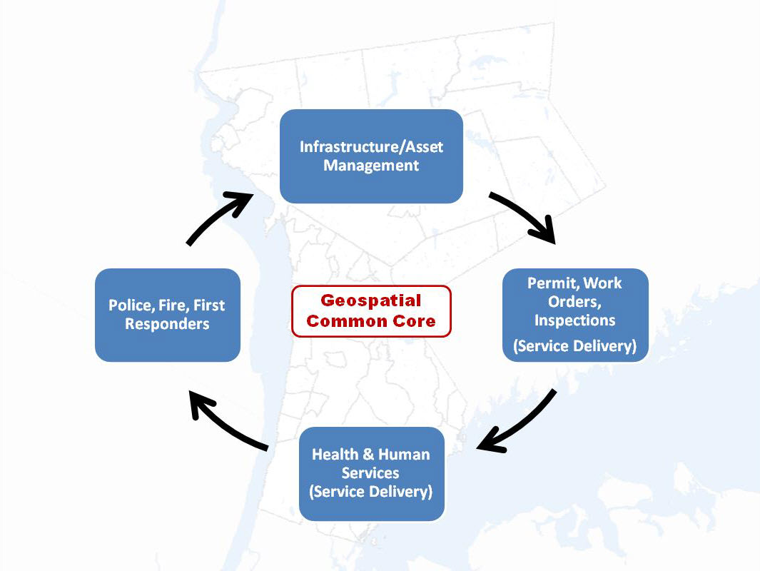
At the Fall 2015 NYGeoCon in Albany, I presented a paper focusing on specific GIS applications which provide a framework for establishing  and maintaining  GIS/geospatial programs in local  governments (villages, towns, cities, and counties) across  New York State.  I refer  to these applications areas as the Geospatial Common Core, many of which are integrated with local government office and administrative business systems.  Others are utilized in the support of regulatory reporting programs.    Together, the Geospatial Common Core contributes in helping build sustainable geospatial capacity for local governments.

GIS Common Core application areas in local government

GIS Common Core application areas in local government

Since NYGeoCon, I have used this initial presentation as a starting point to examine and discuss each of the Geospatial Common Core areas in further detail as part of individual blog posts.  In early December 2015   I submitted Part 1:  Infrastructure and Asset Management which focused on the growing and critical role local government GIS geospatial programs continue to serve in rehabilitating and maintaining the decaying statewide public infrastructure.  And it comes as no surprise that this December blog post was submitted and made available ahead of the numerous statewide signature infrastructure related projects  itemized in Governor Cuomo’s proposed 2016 budget. Alignment of statewide local government geospatial programs with the public works, surveying, and engineering communities is strategic and should not be underestimated.

Geospatial Common Core Part 2:  Work Orders, Permitting, and Inspections (WOPI)

With 1,607 general purpose local governments across New York State, the WOPI Geospatial Common Core component is ubiquitous as part of daily work flows at all levels of government.   Rarely a minute goes by across the state without some kind of government permit or work order being issued, an inspection taking place, licenses or violations being issued, or geographic data being collected in  related asset management systems.  These systems are uniquely integrated with the Geospatial Common Core components (infrastructure and assets) reviewed in the December post.  Nearly all WOPI programs are institutionalized and mandatory at the local level, funded through annual operating budgets,  and often aligned with local, county and state regulatory programs.   As such, WOPI systems provide an excellent area in helping justify and build GIS capacity.  (Just to get a sense of the magnitude of these programs, particularly in larger New York State municipalities, visit these links:   Buffalo including one 12-month period that included nearly 19,000 citizen-requested inspections;  Rochester, and Albany (Albany data from www.data.ny.gov)
Continue reading

2016 NYS Spring GIS Conference Specials

With my March Madness bracket already busted just four days into tournament play and watching anymore games for the most part pointless (Syracuse in the Sweet 16, really?),  combined with winter returning and getting out on the golf course also not an option, it seemed like a good time to sit down and compile my annual plug of regional one-day GIS conferences and meetings around the Empire State over the next 4-6 weeks.

Most of the Spring 2016 shows are held in locations accessible via a maximum 2-4 hour drive from all parts of the state, offer a wide range of geospatial topics and presentations, provide excellent networking opportunities among colleagues and industry representatives, and are generally light on the wallet.    And for the GISP folks, most of the shows also provide certification credits.

Sounds pretty good, right? So consider the following options:

GIS-SIG 25rd Annual Conference, April 12th, Burgundy Basin, Pittsford, NY.  Its unfortunate I cannot make GIS-SIG this year as it is one of my most favorite statewide one-day shows.  GIS/SIG provides the premier geospatial professional forum in the Rochester/Genesee Finger Lakes/Western New York region for GIS practitioners focusing on trends and policies relating to new geospatial technologies and current projects.  With a loyal membership and Board of Directors, the size and content of the GIS/SIG conference is broad enough to often substitute as an annual state conference for many GIS practitioners in the western half of the state. This year’s conference again includes vendor displays and an agenda covering topics such as drones, open source, and mobile apps among others as well as a keynote address by Steve Coast, Founder of OpenStreetMap.   Corporate sponsorship keeps the price tag of an individual registration at under a $100 for the day which also includes lunch. Online registration is available and while you are at the GIS/SIG website you can also see the many resources and links GIS/SIG provides to its user community.  This is a great show and if you have the opportunity to attend, I highly recommend it.

Long Island GIS (LIGIS)  2016 Spring User Conference, April 15th, SUNY Farmingdale, Farmingdale, NY.  LIGIS meetings and conferences have grown in structure and content recently and this spring’s April 15th meeting is anticipated to illustrate these continued improvements.  And the big plus for the Long Island GIS community is that the show is free.   While the agenda is close to being finalized, already confirmed is a U.S. Census Bureau “Map Tab Lab” workshop, plans for a user-submitted map session, and anticipated presentations from government, nonprofits, and industry.    Those interested in attending can monitor conference specifics at the LIGIS homepage.  Located in central Long Island on the SUNY Farmingdale campus, this is a not-to-miss conference for the  extended GIS/geospatial community on “the Island” with limited travel budgets.  Make plans to attend.

Northeast Arc User Group (NEARC) Meeting, May 9th, University of Massachusetts, Amherst, MA. Though not in New York State, the 2016 Spring NEARC meeting is conveniently located in Amherst, MA which is easily accessible to the Albany Capital District and GIS professionals in eastern New York State. Once considered the smaller venue of the NEARC suite of meetings, Spring NEARC grew too large at its original site and moved to the conference center at the University of Massachusetts which actually hosted the annual NEARC conference in the early 1990s.   Unlike the GIS/SIG conference which is software vendor independent, this show is very much ESRI centric though is packed with high quality user presentations. Even though only one day, the show  has grown to be so popular that it now competes with the larger multi-day GIS shows and conferences across New England.   Price tag for attending:  $65 which includes lunch.  If you can afford an overnight, activities the evening before downtown Amherst and a hotel room at the UMass conference center make it even more worth your while. (As of the day of this blog post, the May 9th agenda was still in development.)    If your organization is an ESRI shop – this is a Spring show not to miss.

Westchester GIS User Group Meeting, May 12th, Purchase College, Purchase New York. As one of the largest geospatial meetings in New York State, the Westchester GIS User Group Meeting is a free one-day conference held at Purchase College. Made possible by financial support from exhibiting vendors and conference facilities provided by the college, the 2016 agenda tentatively includes user presentations from a geospatial start-up company, Westchester County municipalities, nonprofits, and industry representatives. There is also a  student project contest and post conference training in building Story Maps led by Westchester County GIS staff and a Bring Your Own Device (BYOD) workshop with instructor Austin Fisher.   The Purchase College location provides easy one-day access across the metropolitan NYC area, as well as the broader lower Hudson River Valley and southeastern Connecticut. Agenda and other meeting specifics – including registration – is available from the Westchester County GIS website.

So, if travel expenses are once again limited and/or at a premium, no problemo.  The entire Empire State GIS community is fortunate enough to be close enough to a range of regional geospatial meetings and conferences which are accessible from most areas of the state and provide many of the same benefits of larger shows.

Safe travels!

NiJeL Expands its New York State Presence

Established by Nancy S. Jones, JD Godchaux, and Lela Prashad in 2007, NiJeL is a company founded on the goal of helping organizations and communities building interactive dashboards, infographics and maps, building strong advocacy tools, and to connect with their communities and sponsors.  Ms. Prashad (CEO) currently leads NiJeL, while Mr. Godchaux (CTO) serves as the primary interactive developer, and Ms. Jones provides management oversight and strategic direction.  NiJeL began after the three had volunteered as American Friends for the International Rescue Committee (IRC) in Phoenix, Arizona while attending Arizona State University as graduate students.

After the successful launch of one of their early online mapping applications in support of Duet – a metro-Phoenix nonprofit dedicated to supporting and improving the quality of life for senior citizens – NiJeL relocated main staff in 2011 to Brooklyn, and since then have been engaged in a number of Empire State oriented geospatial projects.

NiJeL uses standard statistical, mapping, and database software, and develop custom open applications for websites, mobile devices, and desktop computing.  “What makes us different from other groups like us in this space is our custom process to assess current data, metrics, and technology workflows with regards to the organization’s culture and specific goals” notes JD Godchaux .   NiJeL works with  a wide variety of organizations and their focus on using open-source components allows the firm to be flexible in how projects are approached and ultimately designed.  Their commitment to open-source tools allows to provide training for technical staff to manage and make changes to the technology solution they deliver to the client.  Illustrative projects include: Continue reading

2016 National Map (TNM) Products and Services for the Empire State

For almost ten years, The National Map viewer has served as one of the more prominent and visible products of the of the U.S. Geological Survey’s (USGS) National Geospatial Program (NGP).  It represents a significant collaborative effort between the USGS and other Federal, State, and local partners in disseminating  nationwide geospatial data, and where available, content from state and local sources as well.

The National Map is easily accessible for display through a web viewer and boasts a rich catalog of map services which can be consumed by and augments a wide range of browser viewing clients.  It now includes the “new” viewer (the original TNM viewer will be retired this year) which provides users with access to geospatial datasets, geographic names, the Historical Topographic Map Collection (HTMC), and the increasingly popular post-2009 US Topo quadrangle product – all for easy access and download.    US Topo maps are modeled on the familiar 7.5-minute quadrangle maps of the period 1947-1992, but are mass-produced from national GIS databases on a three-year cycle.

Selected TNM viewer functions which can be used by the New York State geospatial community will be highlighted in  the  following  sections  including an update on two of NGP’s  most current and visible  projects –  the 3D Elevation Program (3DEP) and National Hydrography Dataset (NHD).  Both of which are made available in the TNM viewer.  If you’re not familiar with the National Map viewer, an easy way to get started is by using newly released USGS TNM tutorials.

3D Elevation Program (3DEP) Continue reading

NYS Local Government GIS Common Core: Part 1

At the 2015 NYGeoCon in Albany, I presented a paper focusing on several GIS applications which often support and justify GIS/geospatial development at the local level.  I refer to these applications and program areas as the “GIS Common Core” and it was my intent to use the presentation as a starting point to expand the discussion further as part of this blog.

While some of the GIS Common Core program areas are not new to the discussion, several factors have contributed to elevating these day-to-day GIS functional areas to the mainstay of local government geospatial efforts.  Though these factors and opportunities vary greatly across the state, some of the more obvious reasons why “GIS Common Core” applications are becoming the foundation of local government programs include:

  • Improved large-scale spatial data integration across key business applications (assessment-inspections-permitting-public safety-utilities)
  • Better address standardization as a result of E911 implementation
  • Significant improvements on the integration between GIS and AutoCAD technologies
  • Establishing capacity to fulfill ongoing/permanent regulatory and reporting requirements (MS4)
  • Broad deployment of software programs in which using/collecting/maintaining X,Y data is implicit and available by default; GIS/geospatial is often no longer considered an “optional” feature
  • Leveraging flexible, easy-to-use browser-based applications which are accessible in a wide range of environments, particularly in the growing government mobile work force.  A work force which expects maps anywhere anytime.
GIS Common Core application areas in local government

“GIS Common Core” application areas in New York State local governments

Continue reading

RESTful Services in the Adirondacks

While on vacation this past August in Lake Placid, I had a chance to meet up with one of my most respected and longtime colleagues, John Barge at the Adirondack Park Agency (APA) in Ray Brook. Lake Placid and the surrounding areas have long been a favorite escape for me dating back to my initial visit during the 1980 Winter Olympics when I was a graduate student across Lake Champlain at the University of Vermont in Burlington.  Being in the area always gives me a chance to catch up with John and compare notes, talk about our careers and  geospatial technology,  and of course, how much gas we have left in our tanks.

John is a special breed having been associated with the GIS program at the APA since its inception back to the early 1980s covering everything from command line ARC/INFO to the current development of web based products and services within the ArcGIS Online environment.  (He actually got started by digitizing APA roads with the first commercial installation of ERDAS GIS software.)  And  along the way, maintaining a reputation as one of the state’s foremost cartographers as illustrated in his gallery of hardcopy maps available on the APA website. Continue reading

Rochester GIS Scholars

GIS Scholars is a Rochester community-based youth program, serving ages 14-21, which started in 2012 at a small neighborhood agency.  Its origin can be traced back to as early as 1988,  when under the support of Joseph Becker,  who at the time was  employed with  the City of Rochester Bureau of Planning,  started a program which provided local youth the opportunity to learn and work with GIS technology by establishing training and employment opportunities.

Since 2014, the GIS Scholars program has collaborated with the Rochester City School District’s Schools Without Walls (SWW) to begin to integrate geospatial learning into overall educational offerings.   In addition to providing office and administrative support, SWW continues to occupy an important role in the Scholars initiative towards helping identify students as potential candidates for the GIS program.  While the relationship with SWW continues, Monroe Community College (MCC) has more recently become a major sponsor of the Scholars program by donating office, administrative, and computing space at their downtown Rochester Damon City Center facility. Additional volunteers, financial donations, as well equipment and software donations from companies such as ESRI, continue to support the underlying purpose of the program.  One Scholar has already completed the Digital World course and two have started the Business GIS course thanks to a donation to the MCC Foundation. Continue reading