NYS Local Government GIS Common Core: Part 2

At the Fall 2015 NYGeoCon in Albany, I presented a paper focusing on specific GIS applications which provide a framework for establishing  and maintaining  GIS/geospatial programs in local  governments (villages, towns, cities, and counties) across  New York State.  I refer  to these applications areas as the Geospatial Common Core, many of which are integrated with local government office and administrative business systems.  Others are utilized in the support of regulatory reporting programs.    Together, the Geospatial Common Core contributes in helping build sustainable geospatial capacity for local governments.

GIS Common Core application areas in local government

GIS Common Core application areas in local government

Since NYGeoCon, I have used this initial presentation as a starting point to examine and discuss each of the Geospatial Common Core areas in further detail as part of individual blog posts.  In early December 2015   I submitted Part 1:  Infrastructure and Asset Management which focused on the growing and critical role local government GIS geospatial programs continue to serve in rehabilitating and maintaining the decaying statewide public infrastructure.  And it comes as no surprise that this December blog post was submitted and made available ahead of the numerous statewide signature infrastructure related projects  itemized in Governor Cuomo’s proposed 2016 budget. Alignment of statewide local government geospatial programs with the public works, surveying, and engineering communities is strategic and should not be underestimated.

Geospatial Common Core Part 2:  Work Orders, Permitting, and Inspections (WOPI)

With 1,607 general purpose local governments across New York State, the WOPI Geospatial Common Core component is ubiquitous as part of daily work flows at all levels of government.   Rarely a minute goes by across the state without some kind of government permit or work order being issued, an inspection taking place, licenses or violations being issued, or geographic data being collected in  related asset management systems.  These systems are uniquely integrated with the Geospatial Common Core components (infrastructure and assets) reviewed in the December post.  Nearly all WOPI programs are institutionalized and mandatory at the local level, funded through annual operating budgets,  and often aligned with local, county and state regulatory programs.   As such, WOPI systems provide an excellent area in helping justify and build GIS capacity.  (Just to get a sense of the magnitude of these programs, particularly in larger New York State municipalities, visit these links:   Buffalo including one 12-month period that included nearly 19,000 citizen-requested inspections;  Rochester, and Albany (Albany data from www.data.ny.gov)
Continue reading

10 Questions: David Bubniak

I’ve been going back and forth with David Bubniak for several months on doing a piece on his geospatial work and efforts with the Southern Tier Central Regional Planning and Development Board (STC) where he has worked for over a decade.  Covering three counties – Chemung, Schuyler, and Steuben – David’s GIS work with STC covers many program areas. A lifelong Southern Tier resident, he and his wife and their two sons live in Waverly,  New York.  David can contacted at gisstc@stny.rr.com.

eSpatiallynewyork:  How long have you been with Southern Tier Central Regional Planning and Development Board (STC)?

Bubniak:  I   started at STC in 2005 and worked here for a year. I left and went to work for James Sewall in the Elmira office (formally Weiler Mapping). I then returned to STC in 2008 and have been here since. Prior to STC, I worked for the Chemung County Metropolitan Planning Office (MPO)  in the early 90’s as a transportation GIS analyst. I then became the General Manager of Chemung County Transit. I then went back to doing GIS in the Northern Tier of Pennsylvania for Northern Tier Regional Planning.  A good friend of mine is a surveyor and I worked with him on the side periodically over the years doing property surveys, deed research and construction layouts.  Those experiences have helped me significantly over the years understanding how to assist people with GIS. I am the only designated GIS person in STC office though we do have planners that use it often.

eSpatiallynewyork:  When did you start doing GIS work?

Bubniak: I started using GIS in 1993. I attended Mansfield University and graduated with a Geography degree with an emphasis in Planning. We used Atlas GIS for projects. I worked part time at the Chemung County Planning department right after I graduated in December 1994.  My first project was mapping senior citizen migration from rural areas back into the City of Elmira for the Department of Aging. When I started at the Executive Transportation Committee for Chemung County (Chemung County MPO) in 1995 I used Unix based  pcARC/INFO and AutoCad. I taught myself how to use both just by studying the manuals and using them for projects. I then started to use ArcView when it was released.

eSpatiallynewyork:  What GIS products do you now use/promote? 

Bubniak:  I use both web and desktop applications. I use ArcGIS server as well as ArcGIS online for my web apps. I do promote both web and desktop apps. I have people using ArcView, ArcReader and ArcGIS Explorer.  I have the Elmira Water Board using ArcGIS desktop with several departments accessing data over their network using ArcGIS Explorer (desktop). The Chemung County Stormwater Coalition uses a combination of ArcGIS online, local data, and data through ArcGIS server.

eSpatiallynewyork:  What agencies/organizations do you work with most closely?

Bubniak:  I do a lot of work for Chemung County departments and towns. I do get involved with the state from time to time. I function sort of as the GIS coordinator for Chemung County but not on formal basis. I work with the Stormwater Coalition, public works, Elmira Water Board, Real Property. I do work and assist several of the bigger towns in the county.

eSpatiallynewyork:  Tell us about the “Southern Tier Central Mapping Application for Local Governments”

Bubniak:  I have four basic parcel viewers. I have one for each county then one for the whole region. They all run the same data from a SQL database.  Chemung and Schuyler Counties connect their county sites to their SDG Imagemate Online application.  I have a Chemung County site tailored to soil and water, Public works and local code officials.  Many county departments and officials use it for their GIS. I have a bunch of project specific web apps I built using ArcGIS for Flash and Silverlight including one for the Keuka Lake Watershed,  a planning tool, and the Susquehanna-Chemung Action Plan.  Those apps utilize other public services and data to cover the whole area. It really depends on the application and the need.

eSpatiallynewyork:  In your capacity with STC, what professions do you work with the most on a day-to-day basis? 

Bubniak:  In addition to my daily responsibilities with TC, I work with several other (government, county, local governments, nonprofits, what?) disciplines including engineering, public works, planning/economic development,  transportation, code enforcement and emergency services.   In many respects and functions I serve as a GIS consultant (though not paid as one) to many organizations and governments across the three county region.

eSpatiallynewyork:  Making maps anymore or is everything online now?

Bubniak:  Mostly everything has gone online, though I still make maps from time to time.  Well designed hard copy maps are always still needed for meetings and discussions.  There is no substitute.

eSpatiallynewyork: From your perspective and experience in the Southern Tier, do you think decision makers and elected officials value GIS technology as a necessity or a “nice to have”?

Bubniak:  For many years it was a “nice to have” and called a cool technology toy.   Though more recently the culture and understanding of geospatial technology has changed within government and among elected officials to considering it much more as a “necessary” tool.

eSpatiallynewyork:  Assuming money and administrative support were in place, what are a couple cost effective (and needed) geospatial applications which you feel STC could develop and available for the three county area?

I would like to have an application or applications similar to how the Town of Southampton, NY is making GIS services available on their website.  They have a fee-based viewer (ePortal).   for Land Manger GIS that was presented at the last New York State GIS Conference.

eSpatiallynewyork:  So what’s next?  What are you working on now?

Bubniak:  Chemung County has just purchased an ELA license from ESRI. I am going to be designing, building multi-user databases and setting up applications for the county. We are going to be implementing a true enterprise system and get away from our current departmentalized GIS systems.

I am currently working on an application to allow  Elmira City Council members to report issues they want resolved. This will be done on tablets and cut out a huge amount of paper work and will bring in a geospatial component at the same time.

Eventually we plan on getting social services involved.   Once we get this off the ground and get things going we are going to look how to improve services in this area of government.  While at Sewall we designed a web application for social services to locate day cares, employers, transit routes and client locations which I believe has potential for regional and county governments.

 eSpatiallynewyork:  So what are you doing when you are not working?

Bubniak:  For many years I competed in power lifting but hurt my shoulder and don’t participate anymore.   I enjoy the outdoors and hunt.    We bought a starter home  many years ago and since then I’ve completely redone the house doing all of the plumbing, electrical, drywall, flooring, etc., myself.    It’s a great location on a dead end road and we own 40 acres.

Both of our boys – ages 9 and 14 – are involved in travel sports (baseball, track/cross country, Tae Kwon Do) so following them around to games and practices is one of our main “hobbies” now – which is all worth it.

2016 NYS Spring GIS Conference Specials

With my March Madness bracket already busted just four days into tournament play and watching anymore games for the most part pointless (Syracuse in the Sweet 16, really?),  combined with winter returning and getting out on the golf course also not an option, it seemed like a good time to sit down and compile my annual plug of regional one-day GIS conferences and meetings around the Empire State over the next 4-6 weeks.

Most of the Spring 2016 shows are held in locations accessible via a maximum 2-4 hour drive from all parts of the state, offer a wide range of geospatial topics and presentations, provide excellent networking opportunities among colleagues and industry representatives, and are generally light on the wallet.    And for the GISP folks, most of the shows also provide certification credits.

Sounds pretty good, right? So consider the following options:

GIS-SIG 25rd Annual Conference, April 12th, Burgundy Basin, Pittsford, NY.  Its unfortunate I cannot make GIS-SIG this year as it is one of my most favorite statewide one-day shows.  GIS/SIG provides the premier geospatial professional forum in the Rochester/Genesee Finger Lakes/Western New York region for GIS practitioners focusing on trends and policies relating to new geospatial technologies and current projects.  With a loyal membership and Board of Directors, the size and content of the GIS/SIG conference is broad enough to often substitute as an annual state conference for many GIS practitioners in the western half of the state. This year’s conference again includes vendor displays and an agenda covering topics such as drones, open source, and mobile apps among others as well as a keynote address by Steve Coast, Founder of OpenStreetMap.   Corporate sponsorship keeps the price tag of an individual registration at under a $100 for the day which also includes lunch. Online registration is available and while you are at the GIS/SIG website you can also see the many resources and links GIS/SIG provides to its user community.  This is a great show and if you have the opportunity to attend, I highly recommend it.

Long Island GIS (LIGIS)  2016 Spring User Conference, April 15th, SUNY Farmingdale, Farmingdale, NY.  LIGIS meetings and conferences have grown in structure and content recently and this spring’s April 15th meeting is anticipated to illustrate these continued improvements.  And the big plus for the Long Island GIS community is that the show is free.   While the agenda is close to being finalized, already confirmed is a U.S. Census Bureau “Map Tab Lab” workshop, plans for a user-submitted map session, and anticipated presentations from government, nonprofits, and industry.    Those interested in attending can monitor conference specifics at the LIGIS homepage.  Located in central Long Island on the SUNY Farmingdale campus, this is a not-to-miss conference for the  extended GIS/geospatial community on “the Island” with limited travel budgets.  Make plans to attend.

Northeast Arc User Group (NEARC) Meeting, May 9th, University of Massachusetts, Amherst, MA. Though not in New York State, the 2016 Spring NEARC meeting is conveniently located in Amherst, MA which is easily accessible to the Albany Capital District and GIS professionals in eastern New York State. Once considered the smaller venue of the NEARC suite of meetings, Spring NEARC grew too large at its original site and moved to the conference center at the University of Massachusetts which actually hosted the annual NEARC conference in the early 1990s.   Unlike the GIS/SIG conference which is software vendor independent, this show is very much ESRI centric though is packed with high quality user presentations. Even though only one day, the show  has grown to be so popular that it now competes with the larger multi-day GIS shows and conferences across New England.   Price tag for attending:  $65 which includes lunch.  If you can afford an overnight, activities the evening before downtown Amherst and a hotel room at the UMass conference center make it even more worth your while. (As of the day of this blog post, the May 9th agenda was still in development.)    If your organization is an ESRI shop – this is a Spring show not to miss.

Westchester GIS User Group Meeting, May 12th, Purchase College, Purchase New York. As one of the largest geospatial meetings in New York State, the Westchester GIS User Group Meeting is a free one-day conference held at Purchase College. Made possible by financial support from exhibiting vendors and conference facilities provided by the college, the 2016 agenda tentatively includes user presentations from a geospatial start-up company, Westchester County municipalities, nonprofits, and industry representatives. There is also a  student project contest and post conference training in building Story Maps led by Westchester County GIS staff and a Bring Your Own Device (BYOD) workshop with instructor Austin Fisher.   The Purchase College location provides easy one-day access across the metropolitan NYC area, as well as the broader lower Hudson River Valley and southeastern Connecticut. Agenda and other meeting specifics – including registration – is available from the Westchester County GIS website.

So, if travel expenses are once again limited and/or at a premium, no problemo.  The entire Empire State GIS community is fortunate enough to be close enough to a range of regional geospatial meetings and conferences which are accessible from most areas of the state and provide many of the same benefits of larger shows.

Safe travels!

NiJeL Expands its New York State Presence

Established by Nancy S. Jones, JD Godchaux, and Lela Prashad in 2007, NiJeL is a company founded on the goal of helping organizations and communities building interactive dashboards, infographics and maps, building strong advocacy tools, and to connect with their communities and sponsors.  Ms. Prashad (CEO) currently leads NiJeL, while Mr. Godchaux (CTO) serves as the primary interactive developer, and Ms. Jones provides management oversight and strategic direction.  NiJeL began after the three had volunteered as American Friends for the International Rescue Committee (IRC) in Phoenix, Arizona while attending Arizona State University as graduate students.

After the successful launch of one of their early online mapping applications in support of Duet – a metro-Phoenix nonprofit dedicated to supporting and improving the quality of life for senior citizens – NiJeL relocated main staff in 2011 to Brooklyn, and since then have been engaged in a number of Empire State oriented geospatial projects.

NiJeL uses standard statistical, mapping, and database software, and develop custom open applications for websites, mobile devices, and desktop computing.  “What makes us different from other groups like us in this space is our custom process to assess current data, metrics, and technology workflows with regards to the organization’s culture and specific goals” notes JD Godchaux .   NiJeL works with  a wide variety of organizations and their focus on using open-source components allows the firm to be flexible in how projects are approached and ultimately designed.  Their commitment to open-source tools allows to provide training for technical staff to manage and make changes to the technology solution they deliver to the client.  Illustrative projects include: Continue reading

2016 National Map (TNM) Products and Services for the Empire State

For almost ten years, The National Map viewer has served as one of the more prominent and visible products of the of the U.S. Geological Survey’s (USGS) National Geospatial Program (NGP).  It represents a significant collaborative effort between the USGS and other Federal, State, and local partners in disseminating  nationwide geospatial data, and where available, content from state and local sources as well.

The National Map is easily accessible for display through a web viewer and boasts a rich catalog of map services which can be consumed by and augments a wide range of browser viewing clients.  It now includes the “new” viewer (the original TNM viewer will be retired this year) which provides users with access to geospatial datasets, geographic names, the Historical Topographic Map Collection (HTMC), and the increasingly popular post-2009 US Topo quadrangle product – all for easy access and download.    US Topo maps are modeled on the familiar 7.5-minute quadrangle maps of the period 1947-1992, but are mass-produced from national GIS databases on a three-year cycle.

Selected TNM viewer functions which can be used by the New York State geospatial community will be highlighted in  the  following  sections  including an update on two of NGP’s  most current and visible  projects –  the 3D Elevation Program (3DEP) and National Hydrography Dataset (NHD).  Both of which are made available in the TNM viewer.  If you’re not familiar with the National Map viewer, an easy way to get started is by using newly released USGS TNM tutorials.

3D Elevation Program (3DEP) Continue reading

10 Questions:  Star Carter

Star Carter is a GIS Analyst with the Development Authority of the North Country (DANC) located in Watertown, New York. Her life and career path read somewhat like a bucket list covering work as an oiled wildlife responder, aseptic laboratory tech, wrangler on a Wyoming horse ranch, federal law enforcement officer, ophthalmic assistant, naturalist tour guide and now knee deep in the geospatial world.

I started a conversation with Star at the 2015 NYGeoCon talking about work and ended up finding out a lot about how one originally from Hawaii ends up living in the snow belt of New York State…..

eSpatiallynewyork:  How long have you been with the Development Authority of the North Country (DANC)? What brought you here? Where did you go to school?

Star:  I was hired at the Authority in 2011 as a temporary GIS technician.  Thanks to a mixture of good timing and hard work, I’m now the GIS Analyst in a team of three GIS professionals at the Authority.  I’m from Hawaii, but I met my husband in Washington, DC.  He is from Watertown, and after a few years in DC, we moved to the North Country.  I have a BS in Animal Science from the University of Hawaii and a Post-Baccalaureate Certificate in GIS from Penn State.  I found GIS while working at a land trust after moving to Watertown. I was hooked from my first map project.  I enrolled in the online GIS program at Penn State and soon after landed my position at the Authority.

eSpatiallynewyork:  Tell us a couple of your most favorite examples of how GIS is used at DANC?

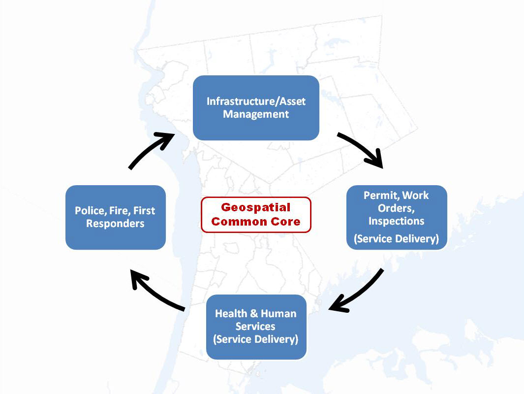
Star:  GIS has become a tool used by all of the Authority divisions, so I have many projects that keep me busy.  The Telecom Division is our largest internal GIS user, with more than 1,400 miles of fiber optic cable mapped in GIS.  The regional landfill and our regional water and wastewater lines are also mapped and updated regularly.  My team is increasingly involved in other less obvious GIS-related projects.  We are supporting two local government consolidation and dissolution studies right now.  When a Village is considering dissolving, or a Town is looking at consolidation with another Town, GIS is the spatial information Holy Grail.  For example, it is used to identify municipal infrastructure systems which need to be turned over to another entity, calculate the total number acres in the municipality, or in determining fire district boundaries.  GIS can help answer many of the tough questions that will inform voters who are making the ultimate decision.

eSpatiallynewyork: DANC represents a regional approach to GIS development.  What makes it successful?  Do you think it can be applied elsewhere across the state?  If so, why? 

Star:  DANC’s mission as a public authority is to provide technical services and infrastructure to enhance economic opportunities in the North Country region.  We exist to make local municipalities’ jobs easier, and GIS is a fast growing part of that challenge.  Many smaller municipalities want GIS, but their limited budgets, staff, equipment, and capacity are barriers to acquiring it in a traditional desktop setup.  The Authority’s shared services GIS model bridges those barriers and allows these communities to enjoy all the benefits of GIS without having to invest in the software and staff to run it.  The Authority has offered GIS hosting services on our web-based GIS application since 2011 (new.dancgis.org).  By June 2016, we will host GIS data for 56 municipal customers in four Counties.  People can access data from any computer or mobile device with an internet connection – that’s all it takes.  Suddenly, all of the infrastructure is at their fingertips and they have tools to interact with it.

I believe the DANC model can be replicated in other areas of the State.  I don’t think every municipality needs its own map viewer. So much money and time is spent on redundant viewers and software that could be better spent developing richer data.  In my experience, consolidating map viewers doesn’t mean that less GIS work is being done – it gives GIS staff more time and funds to work on the data.

eSpatiallynewyork:  Biggest professional accomplishment to date?

Star:  I’m very proud of my participation in the growth of GIS in the North Country and my work on the Authority’s Internet Mapping Application (IMA).  However, two summers ago, I mapped a utility pole line that went up the side of Whiteface Mountain.  Climbing to the top with 15 pounds of computer and GPS equipment was pretty cool and the view at the top was amazing.  I’ve since climbed 2 other mountains in the name of GIS field work – my goal is 46 peaks all on official GIS business!

eSpatiallynewyork:   From your perspective how important is the private sector (business and industry) in building GIS across the state? 

Star:  I collaborate with many private sector engineering firms and other businesses for my projects.  I’ve noticed a positive shift towards GIS technology, where previously the predominate software for engineers I was working with was CAD and they wanted little to do with GIS.  The two technologies can play together very well, and I hope that trend will continue.  The private sector often has the funds/ability/staff to create great data, and there is so much data out there being stored in CAD that would be wonderful to have in GIS.  Someone just needs to do the conversion, which can be time consuming.

eSpatiallynewyork:  What do you think of GISP certification?

Star:  It is something that I’d like to acquire, but so far it has not been a priority.  In my position at the Authority, the GISP is not required for advancement; experience and job performance are more valuable.

eSpatiallynewyork:  Anybody talking “Open Data” in the North Country?

Star:  “Open Data” has become a trigger word for me – bring out the soap box!  All data developed by the Authority is publically available.  We encourage all of our customers to make data public, but it is their choice – about half of them do.

eSpatiallynewyork:  What’s the next big geospatial “thing” for DANC?

We just completed an upgrade to the IMA to make it compatible with mobile devices and more functional.  Like most everyone else in the State, we are looking for user-friendly mobile apps for data collection, both for internal use and for our GIS hosting customers.

eSpatiallynewyork:  If you had an extra $50K in your budget, what would you spend it on?

Star:  I’d spend it on more training opportunities for our GIS staff.  GIS evolves so quickly and it’s too easy to get stuck in your current work flow.  We’re so busy that it’s difficult to take the time to learn about new technology and software, but I think formal training and exposure to new ideas at conferences is important.  And I’d spend it on more equipment – everyone knows that GPS units are like shoes: you need one in every color and style (oooh, this one works under tree cover!).

eSpatiallynewyork: What was the last presentation you made at a GIS conference or meeting?

Star:  I presented at the St. Lawrence County Local Government Conference in 2015.  DANC prepared an all-day track of sessions specifically about GIS – including an Intro to GIS, hands-on training with GPS equipment, and case studies showing how municipalities are using GIS.  I really enjoyed teaching.

eSpatiallynewyork:  So you are up in the pulpit and preaching to the NYS GIS community.  What would the sermon be entitled? 

Star:  “Sharing is Caring for GIS”.  I think the future of GIS includes better data sharing, the application of more shared resources, and more streamlined and standard processes. There are already great strides in this direction. We recently discovered all the amazing data easily accessible from the APA.  I would like to see us implementing more programs that are organized by regions, with GIS staff pushing local data up to shared resources that can broadcast the data to everyone who needs it.

eSpatiallynewyork:  What would you be doing if you weren’t working with DANC?

Star:  I would be back in Wyoming on the horse ranch; mending fences, oiling saddles, and riding through the mountains.

eSpatiallynewyork:  You gotta love snow to live in the North Country.  Cross country or downhill skier? 

Star:  Ha!  Being a surfer girl from Hawaii, the snow is the most difficult part of living here. I survive thanks to an understanding husband who lets me set the thermostat. I like to downhill ski, but last winter we skied Whiteface, which really pushed me to the limits of my skills.  It was terrifying, but fun, in that “I’m glad I did it but I’ll never do it again” kind of way.

NYS Local Government GIS Common Core: Part 1

At the 2015 NYGeoCon in Albany, I presented a paper focusing on several GIS applications which often support and justify GIS/geospatial development at the local level.  I refer to these applications and program areas as the “GIS Common Core” and it was my intent to use the presentation as a starting point to expand the discussion further as part of this blog.

While some of the GIS Common Core program areas are not new to the discussion, several factors have contributed to elevating these day-to-day GIS functional areas to the mainstay of local government geospatial efforts.  Though these factors and opportunities vary greatly across the state, some of the more obvious reasons why “GIS Common Core” applications are becoming the foundation of local government programs include:

  • Improved large-scale spatial data integration across key business applications (assessment-inspections-permitting-public safety-utilities)
  • Better address standardization as a result of E911 implementation
  • Significant improvements on the integration between GIS and AutoCAD technologies
  • Establishing capacity to fulfill ongoing/permanent regulatory and reporting requirements (MS4)
  • Broad deployment of software programs in which using/collecting/maintaining X,Y data is implicit and available by default; GIS/geospatial is often no longer considered an “optional” feature
  • Leveraging flexible, easy-to-use browser-based applications which are accessible in a wide range of environments, particularly in the growing government mobile work force.  A work force which expects maps anywhere anytime.
GIS Common Core application areas in local government

“GIS Common Core” application areas in New York State local governments

Continue reading

Geospatial Business Spotlight: Mohawk Valley GIS

Company Name:                Mohawk Valley GIS

Website:                               www.mohawkvalleygis.com

Established:                          2003

THE COMPANY

Linda Rockwood founded Mohawk Valley GIS in 2003, after her family relocated to Herkimer County, New York.   Previously, she owned North Country Technology Integration in New Hampshire, working primarily with school teachers to integrate technology and particularly GPS and GIS into the K-12 curriculum.

Initially, Linda had planned to continue offering the same type of services in New York, but found more opportunities early on providing GIS system development, data creation and training to municipalities, and designing custom print maps for organizations.

Mohawk Valley GIS moved to historic Bagg’s Square in downtown Utica in 2014 and has grown to include three full-time staff in addition to Linda, who continues to keep her GIS skills current along with coordinating all business development associated with the firm.    Interns from nearby SUNY Polytechnic Institute  and Syracuse University help when everyone starts bouncing off the walls.  The business received NY Women Business Enterprise (WBE) certification in 2013.

PRODUCTS AND SERVICES

The company has expanded to offer a complete suite of technology services including custom interactive online maps and mobile applications to help promote tourism and recreation, as well as to helping businesses, organizations and local governments towards updating websites to be mobile responsive.

By example, GoCaz.com is an interactive web map promoting four season recreation opportunities throughout the Cazenovia area in the Finger Lakes Region.  This particular project is an example of an adaptive, rather than a responsive, mobile application.  The software checks to see what device is accessing the map, then adapts by “offering” the correct version, either large screen or small device screen, as shown below.

The GoCaz website is device independent - enabling users to access the application from different platforms.

The GoCaz website is device independent – enabling users to access the application from different platforms. The browser version screen is on the left and smartphone version on the right.

Mohawk Valley GIS has also been running two promotional, recreation e-commerce sites for the past six years: the winter-oriented NY Snowmobile Trails  and the summer-oriented ADK Trail Map.   The Snowmobile Map application features an interactive map with a route planner, no-reception-needed trail apps with turn-by-turn navigation, and GPS map offerings including Garmin .img file format overlay maps and regional .GPX track files and waypoints.  The application was built in partnership with over 100 snowmobile clubs throughout New York State and was just awarded a NYS GIS Association Applications Award at NYGeoCon 2015.  Many similar functions are available in the ADK Trail Map.  Both projects feature responsive interactive maps, which respond to the device screen size by repositioning elements or eliminating some functionality.

n addition to a massive catalog of snowmobile trails, the application provides access to information on lodging, restaurants, and related travel services

In addition to containing a massive catalog of statewide snowmobile trails, the application also provides access to information on lodging, restaurants, and related travel services.

The route planner and turn-by-turn navigation functionality are built using a pathfinding algorithm which required converting the shapefile representation of the trails to a graph data structure. All geospatial application code in the web map is programmed using Leaflet, an Open Source javascript library.

Core Mohawk Valley GIS services  include GPS data collection, geocoding and digitizing, custom map creation, GIS implementation and training, and GIS data analysis, particularly with regard to big data analysis for predictive analytics and visualization.

Other recent or currently underway Mohawk Valley GIS projects include:

  • Municipality mobile app for Town of Webb/Old Forge, reception required, runs on all mobile devices/browsers, designed primarily for codes enforcement department
  • Municipality mobile app for Warren County, no reception needed, for first responders, focusing on building and structure characteristics
  • Custom paper map design for Vermont Association of Snow Travelers
  • Responsive website for the Herkimer County Chamber of Commerce
  • A unique (at clients request) website, American Electrical Enterprises, which uses a high tech data and chart visualization library
  • Three “big data analysis projects”, all under Non-Disclosure Agreements (NDA), which include  strong geospatial components related to predictive analytics, marketing, and real time data interpretation

To find out more about Mohawk Valley GIS geospatial services and products, visit their website.

CONTACT

Linda Rockwood, Owner

linda@mohawkvalleygis.com

114 Genesee Street, 3rd floor

Utica, NY  13502

315-624-9545

www.mohawkvalleygis.com


10 (Almost) Questions: Todd Fabozzi

Todd Fabozzi is an urbanist, writer, teacher and drummer. During his twenty-two-year career as a regional planner he has been an advocate for cities and sustainable design. He has lectured extensively on suburban sprawl and its consequences and has been involved in numerous urban planning, climate action planning, and watershed protection studies. Todd is an expert on the use of Geographic Information Systems and has taught a course on GIS at UAlbany for the past thirteen years. Todd has also published two books of poems and anti-poems. He lives in the city of Saratoga Springs, NY.

I caught up with Todd at NYGeoCon for a short discussion on life and GIS….

eSpatiallynewyork:  How long have you been with the Capital District Regional Planning Commission (CDRPC)?

Todd:  I’ve been a professional urbanist for the past twenty-two years, twenty of which have been with CDRPC.

eSpatiallynewyork:  What’s one of the best examples of how GIS is used in your organization?

Todd:  I was charged with building the Commission’s GIS back in 1996. One of the first products from that effort was a regional atlas, which we published in oversized hard copy format (this was still pretty much pre-internet). The maps portrayed a whole variety of characteristics at the regional scale, giving the public a bird’s eye view of the spatial patterns of the Capital District for the first time. In addition to applying GIS in most of our program areas, I continue to create, update and publish regional maps (see www.cdrpc.org). I think understanding regional demographic, environmental and land use patterns is central to regional planning and GIS is the best tool for doing so.

eSpatiallynewyork: What professional associations or groups are you affiliated with?

Todd: Over the years I’ve tried out the American Planning Association, the Association of American Geographers, Progressive Planners Network, Congress for New Urbanism, and the NYS GIS Association. I also served for nine years on the NYS GeoSpatial Advisory Council. While for the most part I support the work of these groups, I’m currently unaffiliated (though with CNU and NYSGISA, it’s simply because I haven’t gotten around to renewing). I have to say though that in general I’m not a joiner, perhaps the anarchist in me keeps me at arm’s length from groups and group think.

eSpatiallynewyork:  If you had an extra $50K in your budget, what would you do with it?

Todd:  If it was a yearly allocation I would establish two part-time paid internship positions. CDRPC has been working on a climate and energy issues over the past few years and there are some interesting ways that GIS can be applied. So for example, a good intern project might be to identify (by analyzing the utility zones, solar orientation, area requirements, land uses and zoning laws) the places where community distributed solar might be feasible (community distributed solar allows one to receive solar energy from an offsite location).

eSpatiallynewyork:  Biggest professional accomplishment?

Todd:  Using GIS, imagery analysis and photography to document and portray sprawl and urban decline in the Capital District and through over two hundred presentations inciting a regional conversation on these issues back when it was politically and professionally risky to do so. This was the same presentation I made at the first NYS GeoSpatial Summit in 2006. http://www.nysgis.net/nygeosummit/year/2006/speakers.htm

eSpatiallynewyork:  What do you think of GISP certification?

Todd:  I don’t. I’m not concerned with merit badges. I’d rather let mapping do the talking.

eSpatiallynewyork:  Open Source or ESRI?

Todd:  We’re an ESRI shop but I’m open to whatever works best in a given situation…and the lower the cost the better.

eSpatiallynewyork:   If you could change one thing here in New York that you feel would make GIS more widely used, or more appreciated and understood – what would that be?

Todd:  Start teaching kids how to use GIS as part of the middle and high school curriculum.

eSpatiallynewyork:  What advice would you give to the next generation of individuals starting a career in GIS here in New York State?

Todd:  I’ve been teaching an Intro to GIS course at UAlbany for the past thirteen years and I think I counted seven different people at the most recent NYGeoCon that had taken my course and were now working professionally in NYS using GIS, which is satisfying. I reinforce to my students that GIS is a tool for something else, so get knowledgeable about something else, and then use GIS to help.

eSpatiallynewyork:  Any thoughts on the future of government GIS in the State of New York?

Todd:  There’s not much that state and local governments do that doesn’t have a spatial component, so the more we integrate GIS into government operations the more efficient those operations will be. I’ve heard you sing the gospel of web services for data delivery and I get that and think that is largely the direction things will head. Web-accessible GIS for basic tasks will also continue to proliferate, though there will still be a role for the desktop user with the full suite of tools at their disposal. I saw a presentation at the recent NYGeoCon about the City of Rochester’s various GIS applications that I found quite inspiring and think they’re setting an example of how GIS can be used in local government.

eSpatiallynewyork:  What would you be doing if you weren’t working with CDRPC?

Todd:  Assuming I was retired and didn’t have to earn a living I’d be playing my drums, writing, and traveling.

eSpatiallynewyork:  Your band is in the studio working on its 11th album – what can you tell us about it? 

Todd: Well, as some of my planning and GIS colleagues know, I’m also a professional drummer, and over the past eighteen years I’ve been the conga player for a twelve-piece original salsa band called Alex Torres and His Latin Orchestra. It’s a fun alternative to the office. We get to make people smile and dance, which isn’t something urban planning usually accomplishes. We did a ten-day tour of Shanghai, China this past March, which was a high point for us. And as you noted, we are currently in the studio working on our 11th album. We’ve been in the early rounds of the Latin Grammy’s with a few of our past records. Maybe this will be the one in which we nail it? For anyone interested in the band see: www.alextorres.com.

RESTful Services in the Adirondacks

While on vacation this past August in Lake Placid, I had a chance to meet up with one of my most respected and longtime colleagues, John Barge at the Adirondack Park Agency (APA) in Ray Brook. Lake Placid and the surrounding areas have long been a favorite escape for me dating back to my initial visit during the 1980 Winter Olympics when I was a graduate student across Lake Champlain at the University of Vermont in Burlington.  Being in the area always gives me a chance to catch up with John and compare notes, talk about our careers and  geospatial technology,  and of course, how much gas we have left in our tanks.

John is a special breed having been associated with the GIS program at the APA since its inception back to the early 1980s covering everything from command line ARC/INFO to the current development of web based products and services within the ArcGIS Online environment.  (He actually got started by digitizing APA roads with the first commercial installation of ERDAS GIS software.)  And  along the way, maintaining a reputation as one of the state’s foremost cartographers as illustrated in his gallery of hardcopy maps available on the APA website. Continue reading