Warren County GIS: A Showcase of Geospatial Content for County and Local Government

Program’s modest beginning started in the late 1990s with AutoCAD files and a copy of ArcInfo

Now spending a significant amount of time upstate New York in Essex County, we now find ourselves looking for different routes to take back and forth from southeast New York State instead of the “go-to” I87/Northway option every time.  Just to mix things up – the four-plus hour drive going the normal route can get to be a bit monotonous.

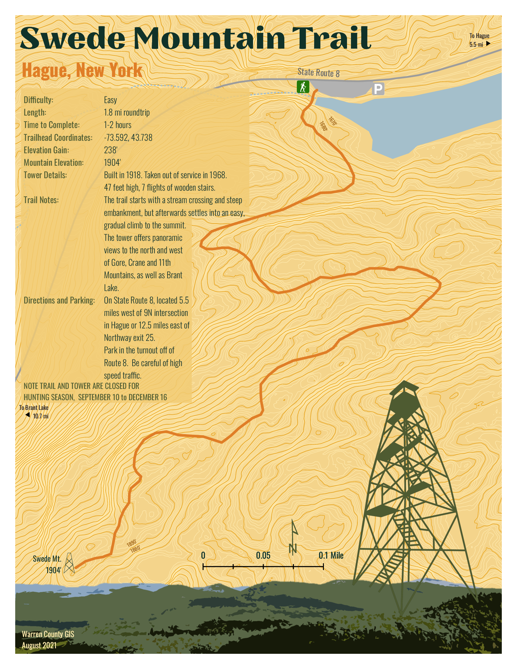
So it was in September I came south out of Ticonderoga headed to Hague (yes, named after The Hague in the Netherlands) on the northern end of Lake George – an area I had never been to.  And it did not disappoint.  Though ultimately to State Route 8 (aka Graphite Mountain Road) to a new Adirondacks trailhead:  Swede Mountain Firetower.  Even though the round-trip hike isn’t that long and relatively easy, it was getting late and I didn’t even get out of the car while in the trailhead parking lot.  Instead, making a note to print out a trail map when I got home.  A couple days later and not having a clue what trail maps were actually available, I Googled “Swede Mountain Firetower trail map” and a candidate list of URLs and image options were immediately returned.  Randomly selecting the one below,  the cartography caught my eye and I quickly looked for the map’s author.  There on the bottom left:  Warren County GIS.  

It was quickly then off to the Warren County GIS website.  Which became the genesis of this article.

Warren County GIS
Just by coincidence, this article coincides with the release of the new Warren County GIS Hub as announced by long-time county GIS Administrator, Sara Frankenfeld.  Overseeing a countywide GIS program judiciously developed over the course of more than two decades – from the days of ARC/INFO coverages to 2022 mobile field apps and interactive online viewing applications.  Also available through the program and Hub is a rich repository of dozens of hardcopy maps available for download covering areas such as countywide outdoor recreation, history, demographics, municipalities, planning and the environment and much more.   An amazing amount of content bundled into three main categories:  Web Maps and Apps | Maps for Print | Download Data.

Background

Originally from the northside of San Francisco Bay in Marin County and earning a degree in Geography from Northern Arizona University, Frankenfeld came to the east coast to initially start work with Dutchess County.  After a short stint with NYSDEC she ultimately made her way to Warren County in 1999 where she got started with a copy of ARC/INFO on a standalone computer in the county building basement.   The county had created a new GIS position in the Planning Department to help convert the tax maps to AutoCAD and then over a period of time converting from AutoCAD to ARC/INFO and then later to geodatabase. 

Over the next four years, she was successful in winning over several other departments on the value and usefulness of GIS technology which she accomplished by focusing on easy, visible “wins” such getting people to use the newly available digital tax parcel data (linked to the RPS data) as quickly as possible and making hardcopy maps.  Lots of maps.  The visibility of the Warren County program also expanded by her working with municipal government zoning administrators and assessors and providing access to the new digital parcel data and including zoning maps,  wetlands data, and FEMA floodplain maps.  A New York State Archives and Administration (SARA) grant enabled the development of a parcel viewer app sby AppliedGIS – where she would later go to work for several years – called the Spatial Data Viewer.  The groundwork was also laid for the implementation of ArcIMS and Imagemate Online.  Somehow she also found time to include outreach programs to local schools and GIS Day.  

After a period in the private sector with (then) AppliedGIS/Fountains Spatial, she returned to Warren County in 2013 where she remains today.  

Today’s Environment

In 2022, the Warren County GIS program is built totally around the ArcGIS Online (AGOL) environment.   Frankenfeld states AGOL has “totally transformed the workplace” and furthers her two main goals of (1) improving public access to data and (2) streamlining/improving processes for county departments and organizations the GIS program supports.  She, along with GIS Specialist Amanda Beck, have embraced StoryMaps, Dashboards, Hubs and Survey123 in ways to make it easy for non-tech users to create and maintain data and access it.  While many of the combo Survey123/dashboard applications are internal facing, others, like the Lake George Milfoil Harvesting real-time app is available to the public.  And so is the Capital Improvement Project Planning viewerBoth respond to GIS requests from local municipalities, local organizations including  the Adirondack/Glens Falls Transportation Council (AGFTC), Lake George Park Commission and the Lake Champlain Lake George Regional Planning Board – all of which have tech support contracts the County.  Projects range from data compilation to hardcopy map preparation to creating and supporting online apps.  Usually these three organizations know exactly what they want, but GIS staff we do often try to suggest ways to streamline or improve their requests.  For example, County GIS staff helped AGFTC come up with a method to inventory sidewalk/crosswalk/curb ramps for ADA transition plans that proved really popular and resulted in a training session for all the Metropolitan Planning Organizations (MPO) in the state.
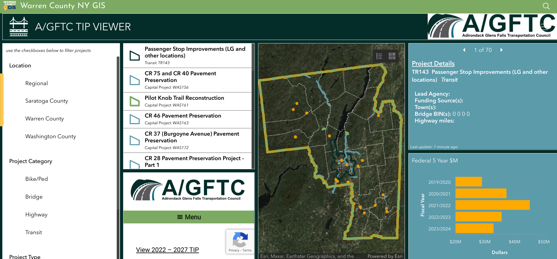
Dashboard for Adirondack/Glens Falls Transportation Council’s Transportation Improvement Program projects.

Having transitioned to ArcGIS Pro to support data editing, cartography and more complex analysis, Warren County GIS staff do a majority of their work in AGOL which includes the mobile pieces Field Maps and Survey123.  They still collect GPS data as needed (usually related to recreation or e911) and support field operations, such as collecting milfoil harvest or infrastructure data, for other users.  They also have Trimble boosters and cell phones which can be checked out to both county staff and municipalities for field data collection along with field worker licenses.   While there are still a few remaining ArcGIS desktop users, most users are using AGOL with named users in Planning, Soil and Water, Public Affairs, the Sheriff’s Department, Office of Emergency Services, Public Works, and Parks and Recreation.  Address and road centerlines are uploaded to the state twice a year and parcel data once a year.  A large current project Sara and Amanda are currently working on is building additional GIS capacity and functionality in County Department of Public Works.

Except for Queensbury which has its own full-time GIS staff person, Warren County GIS supports all municipalities in the County.  At the beginning of the program, Sara had  set up each municipality with desktop GIS as well as providing training and support.  In hindsight and it comes as no surprise this desktop support  was the most time consuming element of her job in the early years.  With the advent of online GIS, County staff has transitioned most of the towns off of desktop GIS, although there are a small number of towns which still use the desktop client.  Most local communities across the County now utilize new AGOL applications.   “We often will take the initiative with projects for the towns that relate to work the County Planning Department is doing such as the Warrensburg buildout analysis“, notes Frankenfeld, “as well advocating the adoption of Field Maps for maintaining water and sewer data.”

New GIS Hub

As noted previously, the new Warren County GIS Hub contains three main areas of content:  Web Maps and Apps | Maps for Print | Download Data.  Each area is then broken down further thematically into categories such as recreation, environment, transportation and infrastructure, planning and zoning, history, citizen reports and more.  With an established user community in County government, most of the time departments and organizations now approach GIS staff directly with applications to develop to support their business needs such as the Safe Pace, Opioid Dashboard, Storm Reporter, TIP viewer, etc).  Other projects have been initiated by GIS staff themselves such as the covid hub and election polling locator.   GIS staff work frequently  with other Planning Department and and apply grant funding to create projects such as History Mapper and the letterboxing challenges (Letterboxing Trail and Historians’ Challenge).
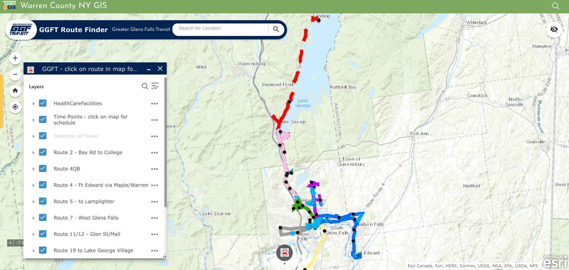
Geospatial viewers are excellent for publishing public transportation systems content. In addition to making time tables and schedules available, ones such as the GGFT also include important public sites such as health care facilities.

Today the COVID Hub is the most popular app though much simplified from early COVID and no longer maintained by the GIS team.   It’s had around 1.5 million views  since its inception in April 2020 – not bad for a county with a population of 64,000   The next most popular is the parcel viewer app (Community Map), which gets about 12k views a month.  After that, the First Wilderness website (about 7k views a month) and the Recreation Mapper which gets a couple hundred views a day, higher in the summer.  Warren County’s primary industry is tourism and is an outdoor recreation destination, so trail maps and recreational resources are popular content and Sara and Amanda spend a substantial amount of time creating and maintaining recreation data and providing access to it.
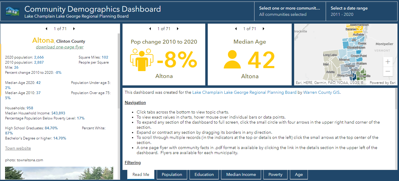
Warren County GIS provides technical support to the Lake Champlain Lake George Regional Planning Board which extends beyond the Warren County footprint. This viewer contains both American Community Survey and 2020 Census data for areas in the five north country counties covered by the Regional Planning Board

Though the application was closed in August, another public facing app focused on the American Recovery Plan Act (ARPA).  Survey123 was customized to create an application for those organizations interested in applying for ARPA funding.  The applications were made available to committee members for review through a Dashboard, and scoring was completed using another Survey123 form.
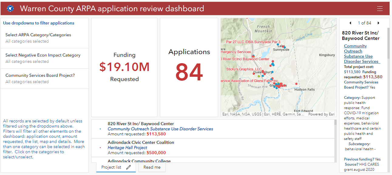
American Recovery Plan Act (ARPA) grant monies provides funding for investment in a wide ranges of community programs and services including geospatial efforts in the rehabilitation and mapping of infrastructure systems.

Sara’s Law

There probably aren’t many geospatial professionals working today across the Empire State that are familiar with Sara’s own little piece of New York State GIS history.  The year was 2002 and it was during her first stint with Warren County.  While using a GPS unit to map the locations of fire hydrants in the North Creek area, she was “challenged” by the professional surveying community of mapping features in a manner/way she was not qualified to do so.   Her post to New York State GIS listserve at the time describing the events read:

“In January, I(Sara) was contacted by an investigator from the New York State Education Department’s Office of Professional Discipline.  They had received a complaint from a surveyor stating that I was surveying without a license.  I was using a Trimble Pathfinder Pro XR GPS unit to collect fire hydrant locations and then plot them on a reference map.  Two investigators met with myself, our planning director, and our county attorney.  The investigators were unfamiliar with GPS and GIS and were basically on a fact-finding mission.  The investigation has progressed, and today we met with the two investigators, an attorney from the Office for Professional Discipline and a surveyor from the New York State Board of Licensed Engineers and Land Surveyors.  The state’s attorney told us at the beginning of the meeting that after reviewing the facts in the case, they do feel that we are guilty of practicing surveying without a license.  She then gave our county attorney a chance to state our case, which I thought he did very well. We were informed that the board will make a decision within the next week.”

At the time, it WAS a really big deal in the statewide geospatial and surveying communities – particularly New York State Association of Professional Land Surveyors (NYSAPLS) and the subject of much discussion and debate.  Significant in that it marked, for the first time, the visible intersection of emerging GIS/geospatial technologies and the professional discipline of surveying – and by extension, engineering in New York State.    While legislation (A01927 & S04396) was proposed in the 2007/2008 timeframe looking to “enhance the definition of land surveying with current standards and tools, i.e., GPS”, nothing was ultimately passed.  And along the way over the course of several years, the discussion and the proposed legislation became known as “Sara’s Law”.  

Little did she know the backpack GPS unit she was using in 2001 in North Creek would one day be the beginning of bringing these different, but similar geospatial technologies together as they are today.   Sara’s place in NYS GIS lore is secure.  

Summary

In addition to the broad presence the Warren County GIS program has throughout county government, it also represents the great relationship and guidance county geospatial programs can provide and offer to local governments.   Local governments that often have both limited financial and technical resources can benefit greatly from county GIS which have technical expertise and infrastructure in place.  A model that can be replicated in other areas across New York State.   

Contact

Sara Frankenfeld
GIS Administrator
Warren County GIS
Warren County Municipal Building
Lake George, NY 12845
frankenfelds@warrencountyny.gov
518-761-6410

10 Questions: Rochelle Harris, President, New York State Assessors Association

Rochelle Harris, IAO, is the current President of the 900-member New York State Assessors Association which represents government assessors and industry representatives across the Empire State.  She currently serves as an assessor in both Madison and Chenango Counties.

eSpatiallyNewYork: You work in both Madison (Hamilton) and Chenango (Sherburne and North Norwich) Counties.  When did you begin to see computer mapping and technology changes in your offices?
 Harris:  I began to notice changes in 2009 – particularly in Chenango County – when a new County Real Property Tax Director was hired.  It was the first time that we were able to overlay aerial photography on top of the digital tax maps.

eSpatiallyNewYork: New York State Assessment Community Enterprise System (ACES) looks like a big deal – aka RPSV5.  How is this program moving along and the discussion within the Association?

Harris:  We are waiting for direction and an updated timetable from ORPTS.  There are also many pilot counties and municipalities which provide updates on progress and any issues. We will be holding training classes when the time comes.

eSpatiallyNewYork:  Do you feel there would be a benefit for more “GIS/computer mapping” training for the statewide assessor community?  Could better engagement with the GIS community improve this in anyway?

Harris: More education can never be a bad thing. Absolutely anything we can do to work together with another agency or organization makes all our lives more efficient. Our current training opportunities can be found on our website which is updated often.

eSpatiallyNewYork: Are you familiar with the New York State GIS Association?

 Harris: I actually am.  Keith Ducette, who is a GIS Technician with Onondaga County, introduced me to the organization and its programs.

eSpatiallyNewYork: Does the Assessors’ Association have anything like a GIS Work Group or GIS Committee?

Harris:  Currently, we do not, but if there is ever an overhaul or a reason to have one, we can create a special committee, or ask for volunteers for temporary projects such as ACES.

eSpatiallyNewYork: Has the Association ever approached the State to support/fund statewide capture of oblique (i.e., Pictometry/Eagleview) imagery?

Harris: No we have not, although it’s a great idea. There is a state senator trying to pass legislation for a cycle bill in which she suggests updating imagery and access to it.  We currently have access to oblique imagery in both Chenango and Madison Counties.

eSpatiallyNewYork:  With regard to data sharing – the conflict of “giving” digital assessment/tax parcel data away vs. “selling it” continues.  A mix across the state.   Does the Association have a position on this?

Harris:  My personal position, I have no problem giving the information for personal use but anyone who wants it for commercial and financial gain should pay for it.  We as an association do not have a position on this.  Chenango County offers a subscription service for the data while Madison County sells tax parcel data in file format.

eSpatiallyNewYork:  Do you anticipate any RPSV5 or any mapping items to be part of the Association’s 2019 Legislative Agenda? Revisions to 9NYCRR Part 189?

Harris:  We are working on our agenda and so far nothing on either issue though revising Part 189 would be a great idea.  The maps are cumbersome and in all three of my offices I am running out of places to store them.  I could mention this to our legislative chair and see if it is something we may be able to add to the agenda or suggest to one of the Senators we work with.

eSpatiallyNewYork: How are assessor’s “automating” in-field assessment work? What are some of the new technology tools?

Harris: I think when we get ACES  there will be much more opportunity to work with the program in the field as it will be mobile friendly and able to incorporate oblique imagery.  There are also digital tools to measure and draw new construction.  I know quite a few Assessor who solely use pictometry and the measuring tool on there.

eSpatiallyNewYork:  I see that you reference Josette Polzella on the President’s Page.  She was an early and vocal advocate of GIS in Westchester County going back to the late 1990s.     Tell me about your relationship with her.

Harris: Josette, was one of my very first mentors.  She was a wonderful person always willing to help and go the extra mile to help. We moved away from the Hudson Valley in 1988 and we lost touch.  We found each other on Facebook in around 2009 or so and picked right up where we left off. She sponsored me to take the IAO exam in 2010 and was there when I was installed – it meant the world to me. The world is a lot less bright without her in it.


Shared Services: Opportunities for Local Government GIS

More than a couple years ago, Linda Rockwood, who at the time was running Mohawk Valley GIS, mentioned to the NYS GIS community that she was at a local meet and greet with regional elected officials and mentioned the “GIS” word to one of NYS’s congressional representatives in attendance.  To her amazement – and dismay –  she found out the representative had a very limited awareness or understanding of GIS.

Linda’s encounter certainly wasn’t the first of its kind and I’m sure there have been numerous similar incidents in our respective corners of the state since then.  GISers gingerly starting a conversation on the broad benefits and applications of geospatial technology to government and elected officials – only to see the focus wander quickly. Maybe two or three minutes into the discussion when comparisons to Google Maps normally kick-in and/or there is eye contact with the next constituent and thinking moves to that conversation.

Unfortunately, the message – and the collective mission – seems to continue to get lost and there is recent anecdotal evidence to suggest there is still a long way to go in context of recognizing and embracing geospatial technology in NYS local governments (county, city, town, and village) as part of an increasingly important government program area:  Shared Services.

New York State Shared Services Program

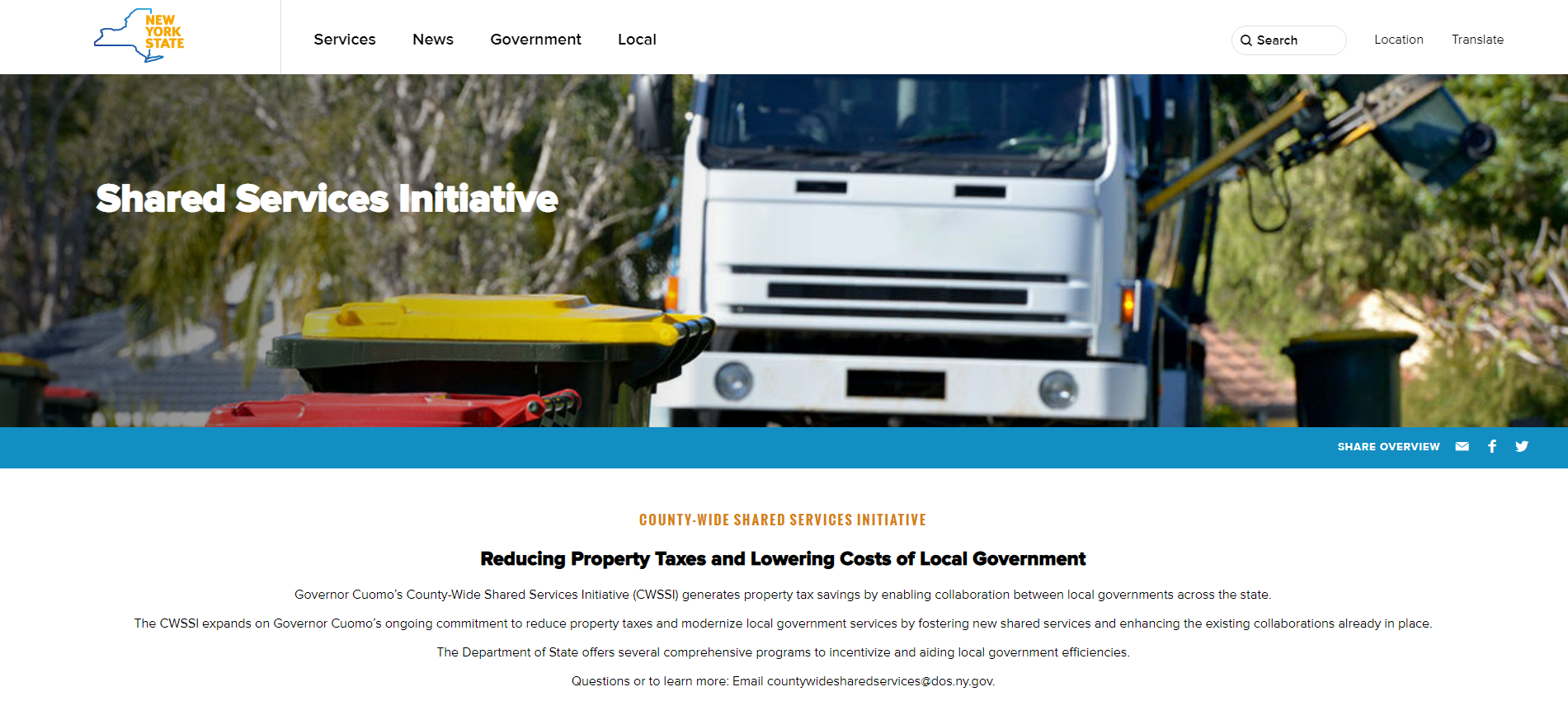
Those working throughout the local government ranks should be on some level familiar with the shared services buzzword.  It’s the talk among government officials and for legitimately good reasons.  Look no further than Governor Cuomo’s commitment of $225 million in the FY 2019 Executive Budget to continue the County-Wide Shared Services Initiatives (CWSSI). The $225 serves as matching funds for a one-time match for actual and demonstrable first-year savings achieved by the Shared Services Panels through new actions implemented during calendar year 2018.  School districts, boards of cooperative services (BOCES), fire districts, fire protection districts, and special improvement districts have the option to participate as well.    The current shared services initiative augments the existing NYS Department of State Local Government Efficiency (LGe) Program – which by the way formerly known as the Shared Municipal Services Incentives program –  “provides technical assistance and competitive grants to local governments for the development of projects that will achieve savings and improve municipal efficiency through shared services, cooperative agreements, mergers, consolidations and dissolutions.”

New York State Shared Services Initiative web page

There are many recognized barriers to implementing shared services across NYS governments though as the concept evolves, governments continue to try and find ways to consolidate services in specific areas such as municipal justices, zoning and code enforcement, construction/building/maintenance inspections, and in the establishment of health care consortiums to name only a few.   That said, it’s worthy to note the limited number of GIS-centric shared services proposals submitted by both the New York State Association of Counties (NYSAC) and  New York Council of Mayors (NYCOM). Specifically:
Continue reading

10 Questions: Bob Wills

Bob Wills, Senior GIS Project Coordinator, Dutchess County Department of Planning and Development has been a mainstay with the Dutchess County GIS program for over twenty years and involved in many Lower Hudson River Valley geospatial projects.  Widely recognized across the state, Dutchess County GIS exemplifies a federated style of GIS development across the enterprise by supporting and building GIS capacity in different program areas. While the geospatial concepts are very similar, though very different, Bob came into the GIS space with an architectural background. He is a Registered Architect in the State of New York and board Certified by the National Council of Architectural Registration Boards (NCARB). I recently caught up with him to talk about the Dutchess County GIS program, it”s history, and current efforts.

Continue reading

Geospatial Business Spotlight: The CEDRA Corporation

Company Name:         The CEDRA Corportation

Location:                     1600 Mosley Road, Suite 500, Victor, NY  14564

Website:                      http://www.cedra.com

Employees:                 12

Established:               1985

The CEDRA Corporation offers GIS based software for mapping, civil engineering design and modeling, surveying and database maintenance applications. CEDRA’s AVseriesTM suite of software operates directly within Esri’s GIS software (ArcGIS® 9.x and 10.x), thus eliminating the need to switch back and forth between various software packages. CEDRA software is developed entirely in-house and marketed worldwide to public works agencies, tax assessors, utilities, municipalities and private sector companies.
Complementing CEDRA’s Software Development Division is CEDRA’s Professional Services Division which has performed consulting projects throughout the U.S. and specializes in developing, populating and maintaining GIS databases.   CEDRA’s Professional Services Division offers consulting services to clients for a multitude of applications including CEDRA-specific software solutions or can be totally non-CEDRA software related consulting projects. CEDRA staff is highly proficient in GIS Analysis, Data Capture, Data Conversion, Map Production, Routing and Custom Application Development in toth the desktop and server environments.  As an authorized Esri business partner and reseller, CEDRA has a long history in the use and application of Esri’s GIS suite of software dating back to 1987.

CEDRA’s corporate mission is to provide services and software that improves the efficiency and productiveness of its clients. This goal is achieved by (a) developing software that is production oriented and (b) offering services that enable clients to streamline workflows. CEDRA believes the more automated a workflow can be made, the more efficient a client will be and a higher quality product will be produced. CEDRA offers Expertise, Experience and Commitment when undertaking a project.

Illustrative CEDRA products and services include:

Wayne County E911, Lyons, New York

Under this project CEDRA assisted Wayne County staff in developing the County’s E911 street database. Specifically, the work involved acquiring the NYS Street Address Mapping (SAM) data, extracting the street data for Wayne County, and working with the County in verifying and updating the street center line database for use in the County’s E911 system.

In performing this work, CEDRA staff was on-site at the County’s office performing the work and training County staff in the process. A workflow was developed and adopted by the County. Additionally, a training guide was developed enabling County staff to maintain the street center line data with their own resources. Continue reading

10 Questions: Dale Morris

Dale Morris is one of New York State’s most recognized and senior GIS statesmen.  With a distinguished civil service career spanning 38 years, he has contributed significantly to the NYS GIS community in many capacities to say the least of directing one of the most established GIS programs in the state at Erie County – and its far reaching influence in western New York.  Ten questions seemed like a slight to an individual with such a body of professional work, so the eSpatiallyNewYork editorial team gave him permission to push it to 15 questions. Or something like that.  Enjoy.

eSpatiallynewyork:  How long have you been with Erie County?

Morris:  I’ve been in the Department of Environment and Planning since 1981. Prior to this I worked as a Planner for the Town of Amherst, NY and before that the Erie and Niagara Counties Regional Planning Board. I graduated from Cornell University with a Master’s Degree in Regional Planning in 1977.

eSpatiallynewyork:  When did you start doing GIS work?

Morris:   Working initially as a Planner for Erie County presented  many opportunities for making and using maps. In the 1980s we were still using Mylar, zipatone, and Leroy Lettering Sets for making maps, which is tedious, time consuming, and not easy to change. I began to investigate the world of digital mapping, which was still in its beginnings as a desktop product. I started with the DOS version of MapInfo. I recall how amazed we all were that we could do something as simple as draw the County and municipal boundaries on-screen. Looking back on it now it all seems so rudimentary!  Regardless of how basic it was, my Division became known for our ability to make computer drawn maps. At that time there wasn’t much concern about the database behind the maps- it was enough to be able to draw and edit maps digitally rather than by hand.

As desktop mapping grew in popularity through the 1990s a number of County departments began independently looking into it. This usually resulted in them calling me to ask for advice or data. Of course, this also meant that everyone was using different systems, and at that time it made exchanging data between systems very difficult or impossible. It was a classic case of disjointed silos of data and applications.

A change in County administration in the late 1990s brought new management in our department, and I was challenged to prepare a white paper for moving the County further forward into the digital mapping world. I proposed creating a new County Division that would be empowered to centralize decisions relating to geospatial technology (by then we could use terms like “geospatial” without getting blank stares!). The Office of Geographic Information Services (OGIS) was born in 2001, and I have been the Director since then. So for me personally, my career started with both feet in the urban planning field, then a gradual shift to one foot in planning and one in digital mapping, and then finally both feet in GIS. I do very little “typical” planning anymore, even though OGIS is part of the Planning Division.

While OGIS is an Office within the Department of Environment and Planning, only a portion of our work is related to this department. We work very closely with our IT shop to maintain and operate the County’s GIS technology infrastructure, and with other departments and outside agencies who either use our enterprise GIS technology or who need direct assistance with their mapping needs.

eSpatiallynewyork:  What’s the relationship between your office and Niagara County?

Morris:  We have a formal Intermunicipal Agreement (IMA) with Niagara County for GIS Services. The agreement is for a five year period and we are well into the second of these five-year agreements. Erie County hosts Niagara County’s geospatial data and provides on-line mapping services to Niagara County. The two counties are connected by a high-speed microwave link, which operates very well. In essence, Niagara County is simply like any other Erie County department that taps into the Erie County enterprise GIS network. In addition to providing Niagara County this service for a fee, the IMA provides a framework for backup of GIS data between the two counties, and as well defines a GIS “mutual aid” protocol for sharing of GIS resources and staff in the event of an emergency.
Continue reading

Queensbury Geospatial: A Model for NYS Town Government GIS

Northbound New York State Northway Exit 20 leads to the Town of Queensbury which is the seat of Warren County.  With a 2010 population of 27,901 the town covers nearly 65-square miles including shoreline along Lake George and lands within the Adirondack Park.  Further into town, several of the usual NYS town government program offices are located at 742 Bay Road including staff and resources which support the town’s geographic information system (GIS).

GIS Background

Prior to 2002, Queensbury officials had worked with consultants to establish initial GIS capacity including the creation of ArcIMS applications and investing in multiple ESRI desktop licenses.  In 2002, the town’s GIS initiative changed significantly with the hiring of George Hilton.  Hired as a GIS Specialist and planner, George was brought onboard to build and advance the town’s  GIS program.

Prior to arriving in Queensbury, George had honed his GIS skills while a student at Central Connecticut State University and later in government positions  in the Denver and Kansas City areas as well as three years with Westchester County.  Now, 15-years after his arrival, George oversees a program which can be considered an exemplary NYS municipal government GIS program.

Current Queensbury Geospatial Products and Infrastructure        

George designs, codes and maintains the Town’s Interactive Mapper (Firefox and IE only) and a host of other ArcGIS.com map viewers including Fire and EMS, Planning and Zoning, and Phase II Stormwater Infrastructure.    He also supports emerging mobile mapping and data collection efforts which includes Trimble GPS units with Trimble Positions to collect data and update feature services and Geodatabases in the field.  The town also collects data (hydrant inspections, site inspections) with ArcGIS Collector using feature services and make maps available through ArcGIS Online.

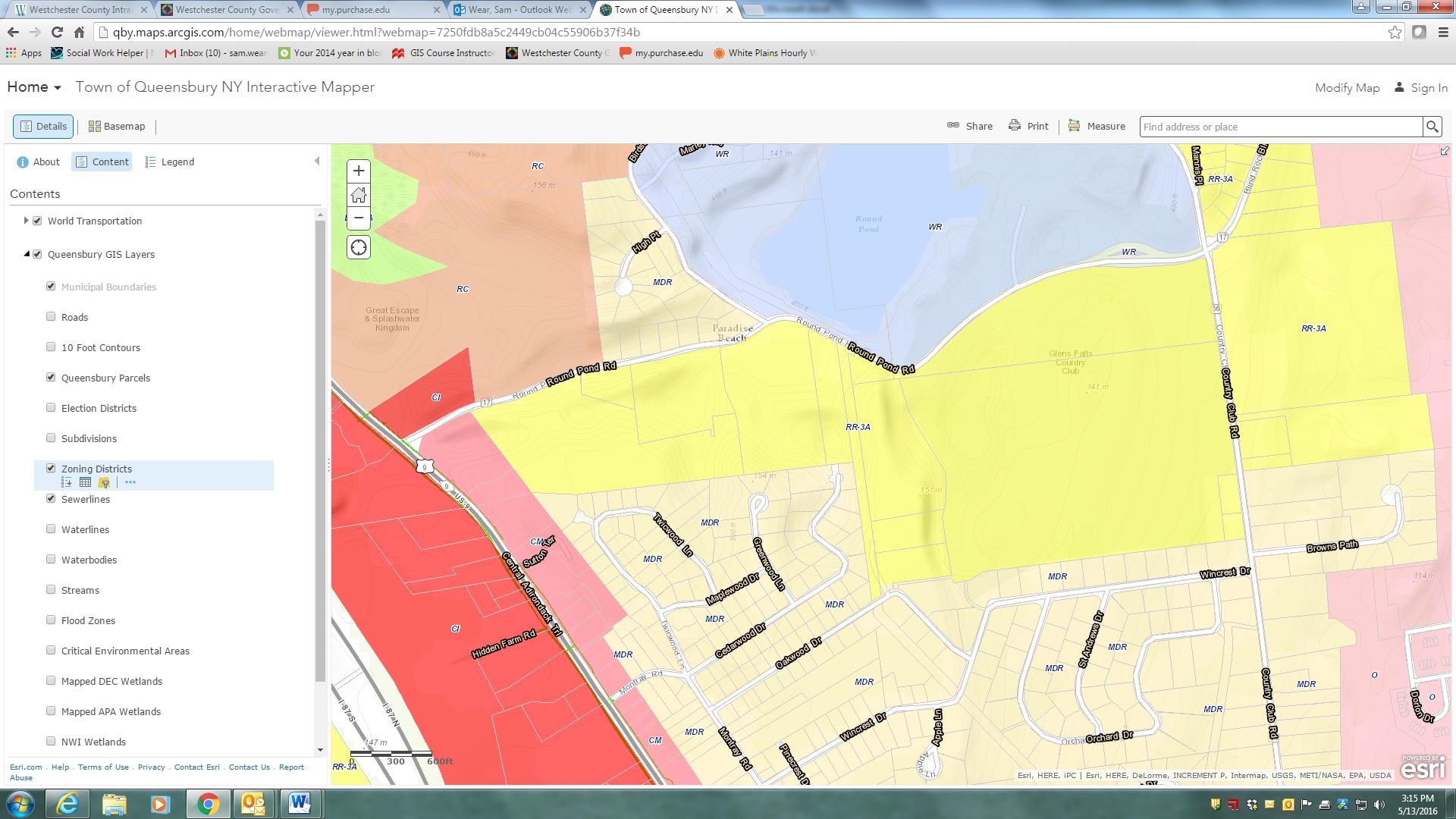
The Town of Queensbury Interactive Mapper includes many locally developed datasets as well as data from other authoritative sources including Warren County, NewYork State and the Adirondack Park Agency.

The Town of Queensbury Interactive Mapper includes many locally developed datasets as well as data from other authoritative sources including Warren County, NewYork State and the Adirondack Park Agency.

Other software components – much of which has been self-taught – George uses inlcludes Sybase (RPS) and SQL Server with ArcSDE as well as ArcGIS Server, ArcSDE, ArcGIS (Advanced), and Spatial Analyst.  The town is currently at ArcGIS Server 10.22 and are testing 10.4 with plans to upgrade very soon.  He also works with QGIS and Global Mapper from time to time.  Global Mapper has been particularly helpful in importing updated USGS topo quads (DRGs) in GeoPDF format into our GIS.

The Queensbury GIS program has grown from primarily providing support to the Planning Department to becoming a very important resource for many departments across town government.  Both the Town Board and Town Supervisor are very supportive of GIS and recognize how much of an important tool GIS has become to the Town.

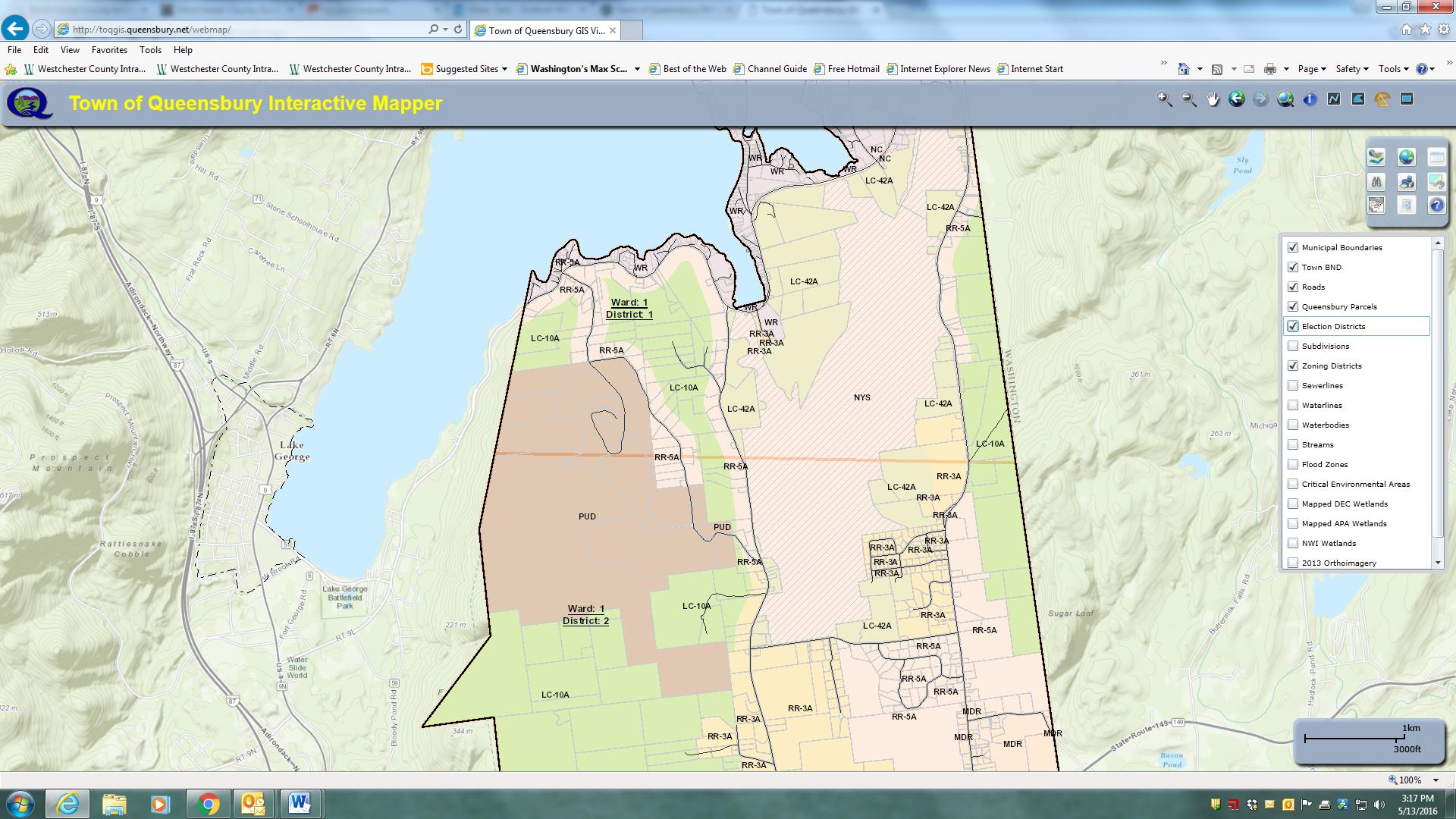
Parts of the Town of Queensbury is actually within the Adirondack Park and therefore subject to stringent land use regulations. This image highlights zoning districts on the southeastern shore of Lake George – within the park boundaries.

Parts of the Town of Queensbury is actually within the Adirondack Park and therefore subject to stringent land use regulations. This image highlights zoning districts on the southeastern shore of Lake George – within the park boundaries.

George maintains an excellent working relationship with Warren County GIS which is under the direction of Sara Frankenfeld where he obtains  parcel data.  The town creates town-wide datasets (zoning, subdivisions, hydrants, infrastructure, environmental, street centerlines, address points, etc) which are then shared back with the County. Referencing her ongoing GIS work with Queensbury, Sara explains:

“George is great to work with and especially in a rural environment where we don’t have any other full-time GIS staff within our respective local governments, it’s so helpful to have a colleague to bounce things off.  He’s a very good sounding board and when I’m considering starting a new project, I often call to get his thoughts.

 We’ve worked closely together on a number of projects.  We recently worked together to streamline the way e-911 addresses are assigned, and this has been a huge improvement to workflows in both of our offices, as well as in the Real Property office, the zoning/building inspectors departments, and the assessors’ offices

 Our current cooperative project is a NYS Archives LGRMIF grant funded project to make the SAM data, along with information about truss roofed structures (as required by a NYS law that went into effect 1/1/2015), and other relevant data such as hydrant locations, available to first responders via an Android/iOS app”.

George also works closely with several state agencies including the Adirondack Park Agency, NYS Parks and Historic Preservation, NYS Department of Environmental Conservation, and NYS Information Technology Services (ITS).  Queensbury Town Supervisor John Strough adds:

“Like today’s computers, I do not know how we lived without him. His GIS services have helped us map the town’s infrastructure structures, trail systems, historic places and many other location details that we absolutely need to comply with the needs of today’s municipal world. I am in his office requesting his services almost as often as am in my budget officer’s office, that’s how important GIS services have become to the town.

Broad User Base

The town enjoys a wide user base including ESRI desktop clients in Planning, Water and Sewer, Assessor, and Parks departments though George is commonly called upon to assist in more detailed data creation, analysis, and cartographic products throughout town government.  He also provides training for users in many local, regional and statewide agencies including the Warren County Soil and Water Conservation District, the Champlain Watershed Improvement Coalition of New York, and the NY State Conservation District Association at their statewide conference in Auburn and Syracuse.

Additionally, George provides maps and data analysis for many community groups, nonprofits, schools, as well as for other municipalities and quasi-governmental agencies in the area.   Queensbury if one of the few municipalities in the area with a GIS program and is often asked to provide support throughout the area.

Creating More Queensbury GIS Programs

While George brought years of GIS experience to the town when accepting  the job, his ability to advance the town’s GIS program has certainly been augmented by ongoing political and administrative support.  Such combination of experience, competitive salary, technical skills and political support is often hard to replicate –   or even find for that matter –  in small town governments across the Empire State.

The Town of Queensbury GIS program speaks to the importance of educating elected officials in the benefits and  importance of investing – both financially and institutionally –  in the role of geospatial technologies in small town governance.  While the Queensbury GIS solution might be considered a typical for similar-sized communities across the state, it nonetheless can be a model for the GIS community to aspire to and replicate.

Visit the Town of Queensbury website at http://www.queensbury.net or George Hilton directly at GeorgeH@queensbury.net.


10 Questions: David Bubniak

I’ve been going back and forth with David Bubniak for several months on doing a piece on his geospatial work and efforts with the Southern Tier Central Regional Planning and Development Board (STC) where he has worked for over a decade.  Covering three counties – Chemung, Schuyler, and Steuben – David’s GIS work with STC covers many program areas. A lifelong Southern Tier resident, he and his wife and their two sons live in Waverly,  New York.  David can contacted at gisstc@stny.rr.com.

eSpatiallynewyork:  How long have you been with Southern Tier Central Regional Planning and Development Board (STC)?

Bubniak:  I   started at STC in 2005 and worked here for a year. I left and went to work for James Sewall in the Elmira office (formally Weiler Mapping). I then returned to STC in 2008 and have been here since. Prior to STC, I worked for the Chemung County Metropolitan Planning Office (MPO)  in the early 90’s as a transportation GIS analyst. I then became the General Manager of Chemung County Transit. I then went back to doing GIS in the Northern Tier of Pennsylvania for Northern Tier Regional Planning.  A good friend of mine is a surveyor and I worked with him on the side periodically over the years doing property surveys, deed research and construction layouts.  Those experiences have helped me significantly over the years understanding how to assist people with GIS. I am the only designated GIS person in STC office though we do have planners that use it often.

eSpatiallynewyork:  When did you start doing GIS work?

Bubniak: I started using GIS in 1993. I attended Mansfield University and graduated with a Geography degree with an emphasis in Planning. We used Atlas GIS for projects. I worked part time at the Chemung County Planning department right after I graduated in December 1994.  My first project was mapping senior citizen migration from rural areas back into the City of Elmira for the Department of Aging. When I started at the Executive Transportation Committee for Chemung County (Chemung County MPO) in 1995 I used Unix based  pcARC/INFO and AutoCad. I taught myself how to use both just by studying the manuals and using them for projects. I then started to use ArcView when it was released.

eSpatiallynewyork:  What GIS products do you now use/promote? 

Bubniak:  I use both web and desktop applications. I use ArcGIS server as well as ArcGIS online for my web apps. I do promote both web and desktop apps. I have people using ArcView, ArcReader and ArcGIS Explorer.  I have the Elmira Water Board using ArcGIS desktop with several departments accessing data over their network using ArcGIS Explorer (desktop). The Chemung County Stormwater Coalition uses a combination of ArcGIS online, local data, and data through ArcGIS server.

eSpatiallynewyork:  What agencies/organizations do you work with most closely?

Bubniak:  I do a lot of work for Chemung County departments and towns. I do get involved with the state from time to time. I function sort of as the GIS coordinator for Chemung County but not on formal basis. I work with the Stormwater Coalition, public works, Elmira Water Board, Real Property. I do work and assist several of the bigger towns in the county.

eSpatiallynewyork:  Tell us about the “Southern Tier Central Mapping Application for Local Governments”

Bubniak:  I have four basic parcel viewers. I have one for each county then one for the whole region. They all run the same data from a SQL database.  Chemung and Schuyler Counties connect their county sites to their SDG Imagemate Online application.  I have a Chemung County site tailored to soil and water, Public works and local code officials.  Many county departments and officials use it for their GIS. I have a bunch of project specific web apps I built using ArcGIS for Flash and Silverlight including one for the Keuka Lake Watershed,  a planning tool, and the Susquehanna-Chemung Action Plan.  Those apps utilize other public services and data to cover the whole area. It really depends on the application and the need.

eSpatiallynewyork:  In your capacity with STC, what professions do you work with the most on a day-to-day basis? 

Bubniak:  In addition to my daily responsibilities with TC, I work with several other (government, county, local governments, nonprofits, what?) disciplines including engineering, public works, planning/economic development,  transportation, code enforcement and emergency services.   In many respects and functions I serve as a GIS consultant (though not paid as one) to many organizations and governments across the three county region.

eSpatiallynewyork:  Making maps anymore or is everything online now?

Bubniak:  Mostly everything has gone online, though I still make maps from time to time.  Well designed hard copy maps are always still needed for meetings and discussions.  There is no substitute.

eSpatiallynewyork: From your perspective and experience in the Southern Tier, do you think decision makers and elected officials value GIS technology as a necessity or a “nice to have”?

Bubniak:  For many years it was a “nice to have” and called a cool technology toy.   Though more recently the culture and understanding of geospatial technology has changed within government and among elected officials to considering it much more as a “necessary” tool.

eSpatiallynewyork:  Assuming money and administrative support were in place, what are a couple cost effective (and needed) geospatial applications which you feel STC could develop and available for the three county area?

I would like to have an application or applications similar to how the Town of Southampton, NY is making GIS services available on their website.  They have a fee-based viewer (ePortal).   for Land Manger GIS that was presented at the last New York State GIS Conference.

eSpatiallynewyork:  So what’s next?  What are you working on now?

Bubniak:  Chemung County has just purchased an ELA license from ESRI. I am going to be designing, building multi-user databases and setting up applications for the county. We are going to be implementing a true enterprise system and get away from our current departmentalized GIS systems.

I am currently working on an application to allow  Elmira City Council members to report issues they want resolved. This will be done on tablets and cut out a huge amount of paper work and will bring in a geospatial component at the same time.

Eventually we plan on getting social services involved.   Once we get this off the ground and get things going we are going to look how to improve services in this area of government.  While at Sewall we designed a web application for social services to locate day cares, employers, transit routes and client locations which I believe has potential for regional and county governments.

 eSpatiallynewyork:  So what are you doing when you are not working?

Bubniak:  For many years I competed in power lifting but hurt my shoulder and don’t participate anymore.   I enjoy the outdoors and hunt.    We bought a starter home  many years ago and since then I’ve completely redone the house doing all of the plumbing, electrical, drywall, flooring, etc., myself.    It’s a great location on a dead end road and we own 40 acres.

Both of our boys – ages 9 and 14 – are involved in travel sports (baseball, track/cross country, Tae Kwon Do) so following them around to games and practices is one of our main “hobbies” now – which is all worth it.