Company Name: Ecology and Environment, Inc.
Location: Lancaster, New York
Website: www.ene.com
Established: 1970
Ecology and Environment, Inc., (E & E) is a global network of innovators and problem solvers, dedicated professionals, and industry leaders in scientific, engineering, and planning disciplines working together with our clients to develop technically sound, science-based solutions to the leading environmental challenges of our time. Founded in 1970 in Lancaster, NY, E & E also has offices in New York City and Albany, as well as locations across the national and internationally. E & E is a fully integrated environmental and engineering company delivering expertise across energy, site assessment and remediation, and restoration and resilience practice areas.
Geospatial Products and Services:
In October 2018, E & E’s IT/GIS group was rebranded as the Data Intelligence Group (DIG) to better reflect the capabilities and services of the department, and how that translates into identifying and integrating opportunities for innovation and streamlined data management into client projects. DIG includes experienced professional application developers and geospatial analysts who collaborate to add value for clients by providing tailored tools to collect and manage data efficiently, collate information quickly to meet aggressive schedules, accurately visualize project data, and support community engagement and project collaboration. E & E has worked on thousands of IT and GIS projects, and has built an extensive library of code that can be efficiently leveraged to complete successful new applications for clients quickly.
Specific E & E geospatial services include:
- Custom Application development (public and private websites)
- Needs Assessment, System Design, Development, Implementation and Maintenance
- Database Development and Data Management
- Data Visualizations (e.g., Tableau, ArcGIS Insights)
- Field Data Collection and Management (GPS, Mobile Mapping)
- GPS/GNSS Support
- Mobile map viewers and custom mobile application development
- 3D Visualization and Modeling
- Photo Simulations
- Software and system integration
- Website design, hosting, and maintenance
- Document Management
- Satellite Image Processing
- Database design, interpretation, and migration
- Training and Technology transfer
- Web-integrated Monitoring of Telemetered Data Feeds
- Unmanned Aerial System (UAS) Site Survey
- Augmented and Virtual Reality
- GIS Process and Workflow Analysis
- GIS Training
- Desktop Geospatial Services (e.g., Cartography/Report quality mapping, Geospatial Analysis, Spatial interpolation and Modeling)
- Process Automation
Mapping Offshore Wind for NYSERDA
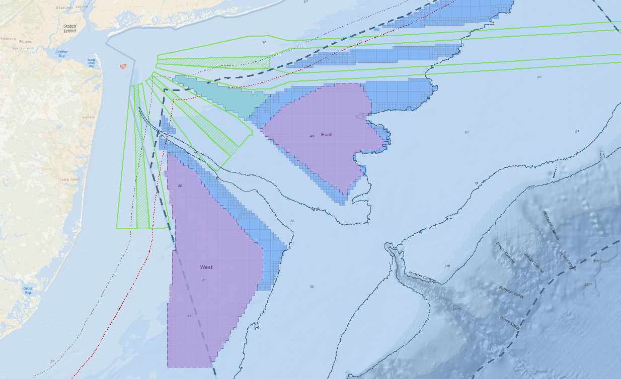
To support New York State’s commitment under the Clean Energy Standard, which requires that 50 percent of the State’s electricity come from renewable energy sources, E & E worked closely with the New York State Energy and Research Development Authority (NYSERDA) to contribute to the first-of-its-kind New York State Offshore Wind Master Plan. The plan lays out a path for development of 2.4 gigawatts of offshore wind – enough to power 1.2 million homes. Geospatial tasks associated with this project included:
- Development of an interactive web mapping portal for team and public engagement
- Offshore and near-shore data acquisition
- Geostatistics of potential offshore wind development areas
- Development of detailed map figures for published reports

Areas for consideration and indicative wind energy areas were one result of the GIS analysis performed with NYSERDA. NYSERDA’s findings were presented to the Bureau of Ocean Energy Management to assist in designating official wind energy lease areas.
E & E also developed GIS modeling that ranked sensitivity of various offshore species receptor groups to the stressors of building and operating a wind farm over different times of the year. Geospatial data and analysis results were used to facilitate identification of areas for consideration for offshore wind development and will inform future developers, potentially reducing the uncertainty and costs of their proposals. Download a copy of the actual Offshore Wind Master Plan.
Geospatial Services for Erie County Water Authority
E & E is proud to have worked with the Erie County Water Authority (ECWA) since 2003, helping them integrate and leverage increasingly robust geospatial technologies to benefit their customers and their bottom line. E & E’s GIS support has been critical to their day-to-day operations. E & E GIS support has provided:
- Field crew mobile access to utility information though maps and data,
- Analysis of water main leaks to target most-effective replacements, facilitating smart capital improvement project planning, and
- Transportation logistical support by optimizing service calls to save on transportation and labor costs.

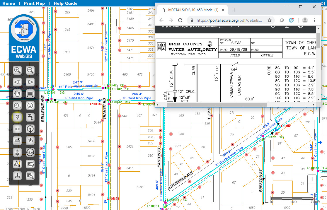
GIS has played a significant role in the location and management of assets at ECWA for the past 25 years. Pictured here is a web mapping application for use in the office, with field laptops, and mobile devices, that assists with locating and identifying assets and related information.
Geospatial Flows for Energy Infrastructure Developers
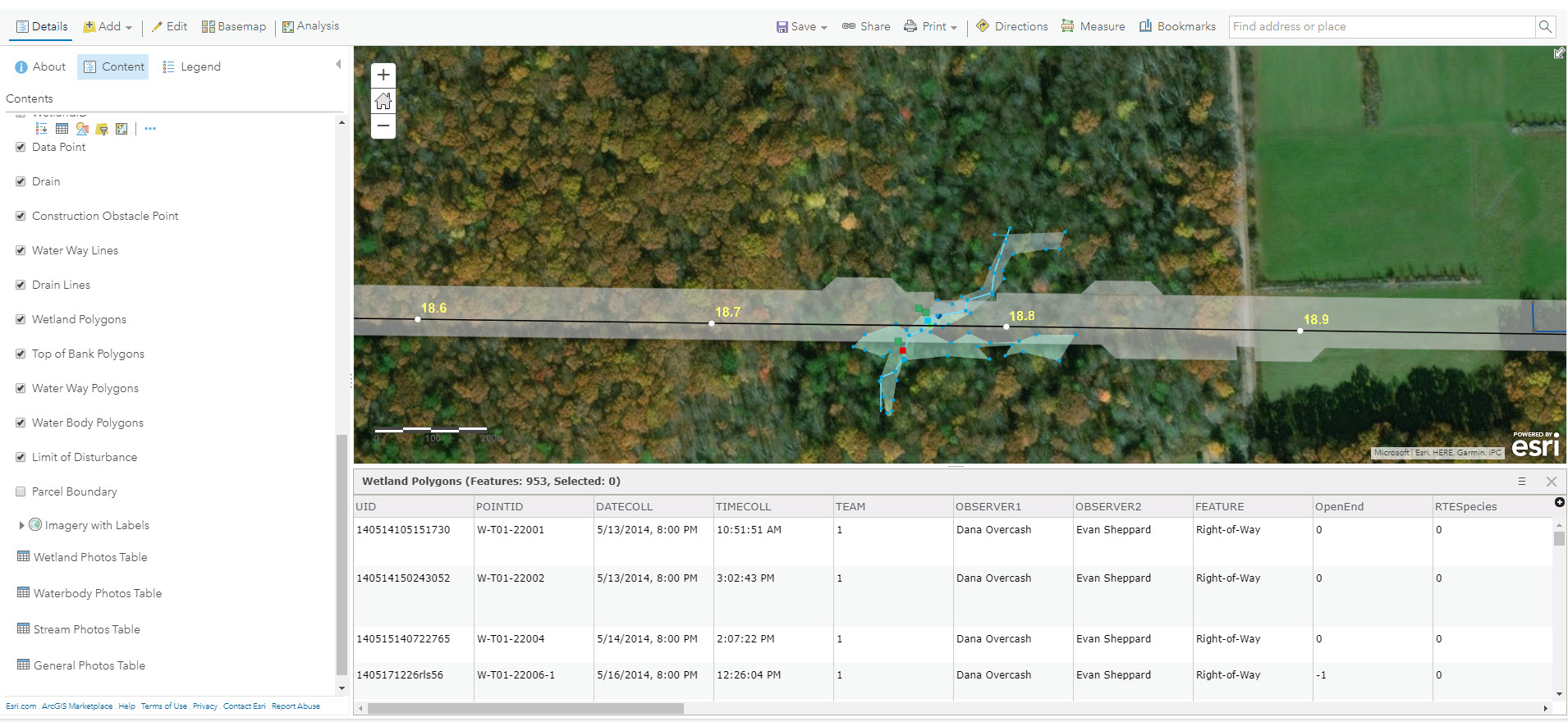
For the Williams Transco 197-mile Atlantic Sunrise project, E & E set up field data workflows for a large environmental survey. In communication with E & E biologists, developers, and the client, E & E developed a customized workflow to meet diverse needs. Solutions included development of a customized ArcPad (Trimble) and ESRI Collector Application, web integration, and desktop automation tools.

ESRI Collector and the ArcGIS Online platform played an important role in the Atlantic Sunrise field data collection process. Data was integrated in near real-time and was made immediately available to project managers, engineers, and decision makers.
Working Smarter with E-Datasheets
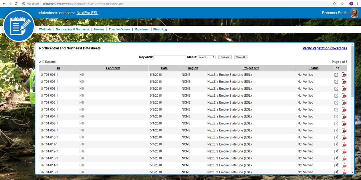
E & E has ditched paper datasheets and is going green! We developed custom “smart forms” that utilize drop-down menus, radio buttons, and behind-the-scenes calculations to speed up the data collection process. These electronic datasheets save time and improve data quality. Data is stored in an enterprise database and can be queried and exported to PDF format for report submittal. E-Datasheets have been used with a wide variety of clients.

E & E has developed electronic datasheets to save time, improve data quality, and reduce waste.
Contact:
Greg Coniglio, PMP, GISP
Ecology and Environment
368 Pleasant View Drive
Lancaster, New York 14086
gconiglio@ene.com
