Geospatial Business Spotlight: Ecology and Environment, Inc.

Company Name:                  Ecology and Environment, Inc.

Location:                               Lancaster, New York

Website:                                www.ene.com

Established:                         1970

Ecology and Environment, Inc., (E & E) is a global network of innovators and problem solvers, dedicated professionals, and industry leaders in scientific, engineering, and planning disciplines working together with our clients to develop technically sound, science-based solutions to the leading environmental challenges of our time. Founded in 1970 in Lancaster, NY, E & E also has offices in New York City and Albany, as well as locations across the national and internationally. E & E is a fully integrated environmental and engineering company delivering expertise across energy, site assessment and remediation, and restoration and resilience practice areas.

Geospatial Products and Services:

In October 2018, E & E’s IT/GIS group was rebranded as the Data Intelligence Group (DIG) to better reflect the capabilities and services of the department, and how that translates into identifying and integrating opportunities for innovation and streamlined data management into client projects. DIG includes experienced professional application developers and geospatial analysts who collaborate to add value for clients by providing tailored tools to collect and manage data efficiently, collate information quickly to meet aggressive schedules, accurately visualize project data, and support community engagement and project collaboration. E & E has worked on thousands of IT and GIS projects, and has built an extensive library of code that can be efficiently leveraged to complete successful new applications for clients quickly.

Specific E & E geospatial services include:

  • Custom Application development (public and private websites)
  • Needs Assessment, System Design, Development, Implementation and Maintenance
  • Database Development and Data Management
  • Data Visualizations (e.g., Tableau, ArcGIS Insights)
  • Field Data Collection and Management (GPS, Mobile Mapping)
  • GPS/GNSS Support
  • Mobile map viewers and custom mobile application development
  • 3D Visualization and Modeling
  • Photo Simulations
  • Software and system integration
  • Website design, hosting, and maintenance
  • Document Management
  • Satellite Image Processing
  • Database design, interpretation, and migration
  • Training and Technology transfer
  • Web-integrated Monitoring of Telemetered Data Feeds
  • Unmanned Aerial System (UAS) Site Survey
  • Augmented and Virtual Reality
  • GIS Process and Workflow Analysis
  • GIS Training
  • Desktop Geospatial Services (e.g., Cartography/Report quality mapping, Geospatial Analysis, Spatial interpolation and Modeling)
  • Process Automation

Mapping Offshore Wind for NYSERDA

To support New York State’s commitment under the Clean Energy Standard, which requires that 50 percent of the State’s electricity come from renewable energy sources, E & E worked closely with the New York State Energy and Research Development Authority (NYSERDA) to contribute to the first-of-its-kind New York State Offshore Wind Master Plan. The plan lays out a path for development of 2.4 gigawatts of offshore wind – enough to power 1.2 million homes. Geospatial tasks associated with this project included:

  • Development of an interactive web mapping portal for team and public engagement
  • Offshore and near-shore data acquisition
  • Geostatistics of potential offshore wind development areas
  • Development of detailed map figures for published reports

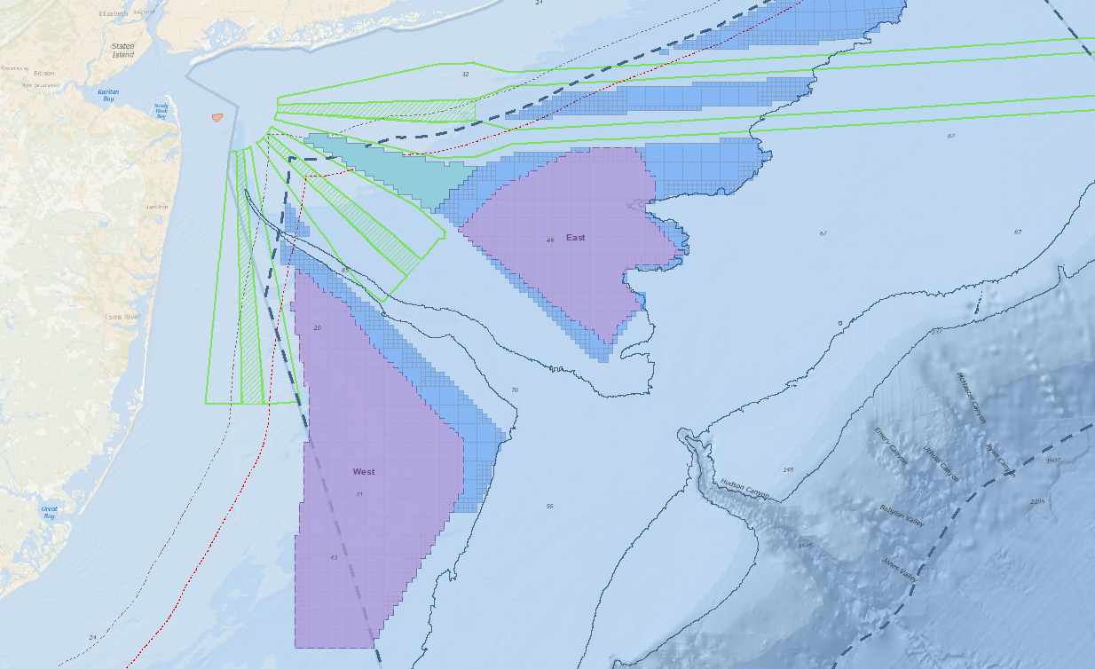
Areas for consideration and indicative wind energy areas were one result of the GIS analysis performed with NYSERDA.   NYSERDA’s findings were presented to the Bureau of Ocean Energy Management to assist in designating official wind energy lease areas.

E & E also developed GIS modeling that ranked sensitivity of various offshore species receptor groups to the stressors of building and operating a wind farm over different times of the year. Geospatial data and analysis results were used to facilitate identification of areas for consideration for offshore wind development and will inform future developers, potentially reducing the uncertainty and costs of their proposals.  Download a copy of the actual Offshore Wind Master Plan.

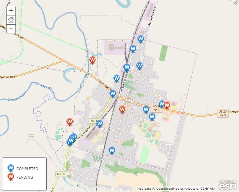
Geospatial Services for Erie County Water Authority

E & E is proud to have worked with the Erie County Water Authority (ECWA) since 2003, helping them integrate and leverage increasingly robust geospatial technologies to benefit their customers and their bottom line. E & E’s GIS support has been critical to their day-to-day operations. E & E GIS support has provided:

  • Field crew mobile access to utility information though maps and data,
  • Analysis of water main leaks to target most-effective replacements, facilitating smart capital improvement project planning, and
  • Transportation logistical support by optimizing service calls to save on transportation and labor costs.

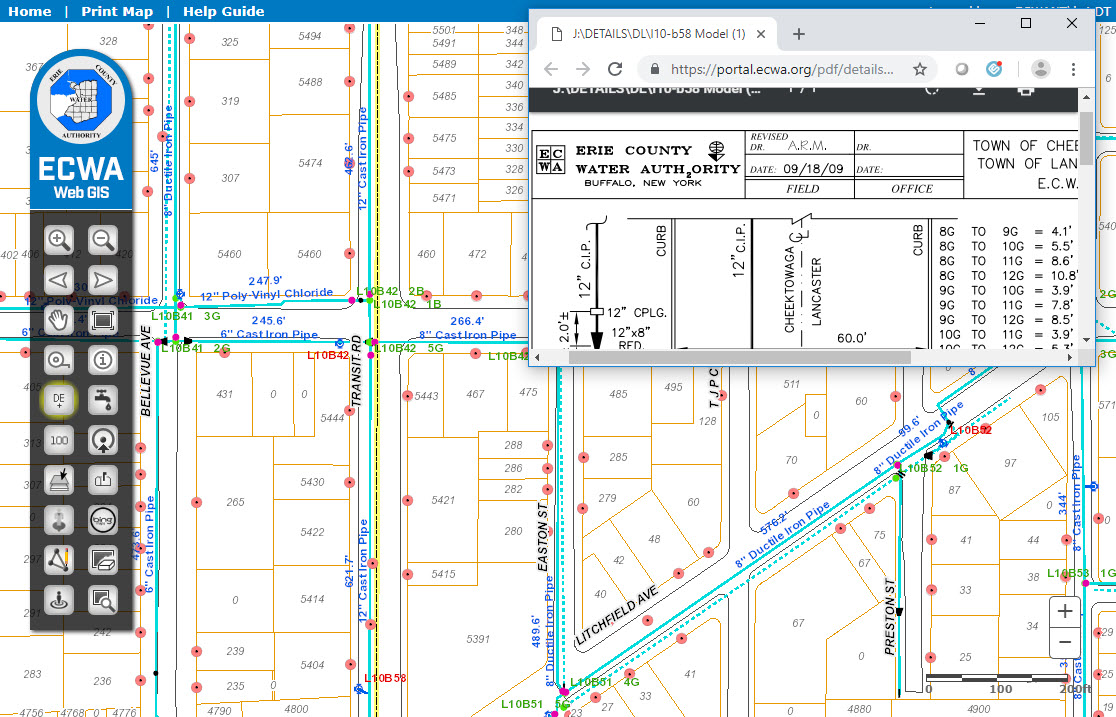
GIS has played a significant role in the location and management of assets at ECWA for the past 25 years. Pictured here is a web mapping application for use in the office, with field laptops, and mobile devices, that assists with locating and identifying assets and related information.

Geospatial Flows for Energy Infrastructure Developers

For the Williams Transco 197-mile Atlantic Sunrise project, E & E set up field data workflows for a large environmental survey. In communication with E & E biologists, developers, and the client, E & E developed a customized workflow to meet diverse needs. Solutions included development of a customized ArcPad (Trimble) and ESRI Collector Application, web integration, and desktop automation tools.

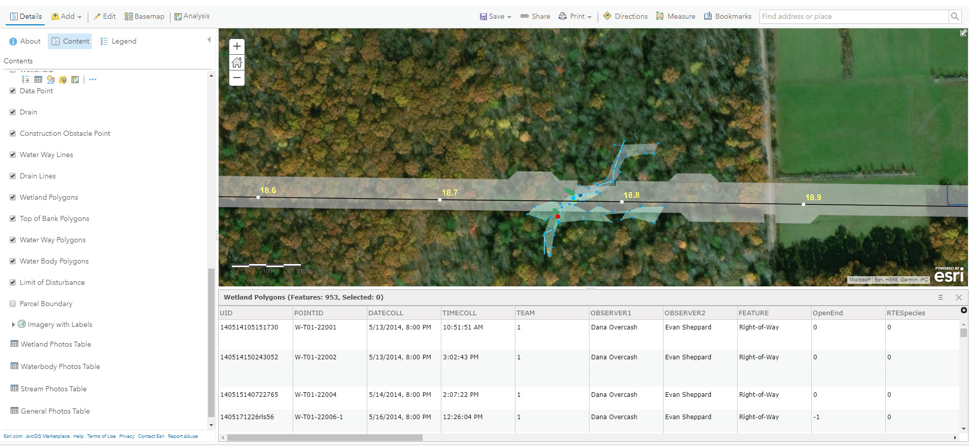
ESRI Collector and the ArcGIS Online platform played an important role in the Atlantic Sunrise field data collection process. Data was integrated in near real-time and was made immediately available to project managers, engineers, and decision makers.


Working Smarter with E-Datasheets

E & E has ditched paper datasheets and is going green! We developed custom “smart forms” that utilize drop-down menus, radio buttons, and behind-the-scenes calculations to speed up the data collection process. These electronic datasheets save time and improve data quality.  Data is stored in an enterprise database and can be queried and exported to PDF format for report submittal.  E-Datasheets have been used with a wide variety of clients.

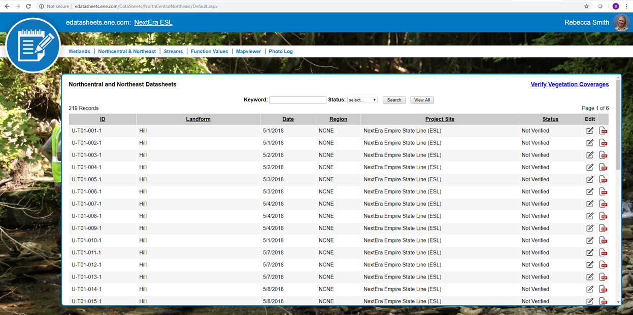
E & E has developed electronic datasheets to save time, improve data quality, and reduce waste.

Contact:

Greg Coniglio, PMP, GISP
Ecology and Environment
368 Pleasant View Drive
Lancaster, New York 14086
gconiglio@ene.com

Geospatial Business Spotlight: CycloMedia Technology, Inc.

Company Name:       CycloMedia Technology Inc.

Location:                   Berkeley, CA

Website:                    www.cyclomedia.com

Employees:               120 Globally

Established:              1981

A privately held company, founded in the Netherlands over thirty years ago, CycloMedia Technology, Inc. is a rapidly expanding international company with staff in Syracuse, New York.  Annually, CycloMedia captures and processes approximately 160,000 linear miles of 360° panoramic street level images, representing over 48 million recordings per year. The company holds five key image capture technology patents and specializes in the local government market. Currently the company has projects with the cities of New York, Philadelphia, Washington DC, as well as  Franklin County, OH (Columbus), Dakota County, MN (Minneapolis) and Jefferson County, KY (Louisville) to name a few.

Specific benefits of Cyclomedia technology include:

  • GeoCyclorama images and basemaps are geographically linked
  • Provides ability to conduct searches with address, postal code or coordinates
  • Integrate with interprise applications and work processes using the GlobeSpotter API
  • Determine the location and dimensions of objects in GeoCyclorama imagery
  • Ability to create precise point, line and area measurements
  • Overlay enterprise spatial data on the GeoCyclorama images
  • Supports Open Geospatial Consortium (OGC) standards
  • Integrate data in formats such as WFS, WMS, Shapefile and GML
  • Create reports and bookmark locations of interest
  • Users can save and utilize GeoCyclorama images for reporting and analysis functions.

Geospatial Products and Services:

A.  GlobeSpotter

GlobeSpotter (web) is an interactive web-based application that provides cloud access to GeoCyclorama imagery and tools for measuring, collecting data, and reporting.  The software and data are directly available from CycloMedia’s software as a service (SaaS) model.

GlobeSpotter (web) screenshot with area measurement and reporting window 

GlobeSpotter for ArcGIS Desktop  provides visualization, measurement and overlay tools within the ArcMap or ArcGIS Pro allowing a user to fully leverage the power of GeoCycloramas within the ArcGIS client environment.  Specific capabilities include:

    • Open GeoCyclorama imagery from a recording point layer added to the map
    • View one or multiple GeoCyclorama images
    • Measure on GeoCyclorama images
    • Use the native editing capabilities of ArcGIS to collect features in 2D or 3D
    • Ability to save and utilize GeoCyclorama images for reporting and analysis functions.

Continue reading

Geospatial Business Spotlight: SkyOp, LLC

Company Name:           SkyOp, LLC

Location:                       5297 Parkside Dr. Suite 435, Canandaigua, New York 14424

Website:                        www.skyop.com

Employees:                  4 + 6 contractors

Established:                January 4, 2013

History

After reading an article in the June 2012 issue of WIRED, SkyOp owner and founder Brian Pitre caught the drone bug.  A self-proclaimed computer-geek, and after nearly 40 years in the computer business, Pitre’s hunch – which very quickly proved to be correct – was that this technology was different.  Very different.  A game changer.  And he immediately immersed himself in learning as much as he could about the technology.

Over the next several months he self-taught himself to fly one and in the meantime designed a drone that would later be manufactured in Canada.  By November 2012 and using $15K of his own money, Pitre was in the drone business. As it turns out, and often the case in the tech business, barely three months later in January 2013 DJI released the Phantom drone for $600.   Today, DJI is the market leader in the drone industry.

 Over the next 18 months, Pitre continued his research into the emerging drone market identifying 68 vertical markets that could use drones. Along the way beginning to build and offering training programs out of is Canandaigua office as well as collaborating with regional colleges.  In November 2014 SkyOp formalized its first college training course with Monroe Community College.

In January 2017, the company was one of six selected from a pool of 250 around the country to compete for $2.75 million in prizes at GENIUS NY, a business accelerator program at CenterState Corporation for Economic Opportunity Tech Garden in Syracuse.  Receiving $250,000 from the Genius NY incubator, SkyOp graduated from the program in December 2017 which helped giving credibility to the company and its training programs.  SkyOp has also received financial support through the New York State Hotspot program as part of the Venture Creations Rochester Institute of Technology Business Incubator.

Today, SkyOp is a premier Empire State UAS training and courseware licensing company having 23 academic partners in nine states.  In New York State alone, SkyOp has established training programs with SUNY Ulster, SUNY Jefferson Community College, Hudson Valley Community College, Corning Community College, and of course Monroe Community College among others.

Training

Class Content

SkyOp offers their coursework in Canandaigua office as well as at educational institutions, sUAS manufacturers, public safety organizations, and businesses.  Regardless of location or educational setting, SkyOp’s core course offerings focus on introductions to the technology/learning to fly, applying the technology to public safety disciplines, and hands-on-training for specific drone units.

SkyOp recently established a strategic partnership with Little Arms Studios, a leading developer of professional-grade simulation solutions.  This business relationships enables SkyOp to deploy Little Arms Studios’ Zephyr Drone Simulator throughout the SkyOp commercial and consumer drone training network which serves much of the Northeastern United States. Zephyr’s unique Learning Management System makes it a preferred solution for SkyOp instructors looking to oversee each student’s development both inside and outside the classroom.  Several other interesting Zephyr drone simulation video examples are available for viewing on YouTube.

FAA Testing

SkyOp is now an authorized FAA Knowledge Testing Center and can administer the remote pilot knowledge test. Individuals can schedule an appointment, call CATS Testing at 800-947-4228, Option 3 and sign up to take the test at our location in Canandaigua, NY. SkyOp is open for testing Tuesdays, Wednesdays, and Thursdays from 10:00am until 4:00pm each week except holidays.

As of August 2016, individuals operating a drone for any commercial or business purpose must obtain an FAA remote pilot certification. The remote pilot knowledge test Unmanned Aircraft – General costs $150, includes 60 questions, and requires a passing score of 70%. With successful completion of the test, you can apply for a remote pilot certificate for FAA Title 14 Code of Federal Regulations Part 107.

Summary

Drones have found a niche in a wide range of industries including construction and engineering, real estate, film and cinematography, public health and agriculture.  Firefighters and police officers have tapped into the technology as well.  Illustrative of their presence within the statewide GIS community, SkyOp assisted in the training of NYS Dept. of Environmental Conservation (DEC) staff which are utilizing drones in the support of spill response, coastline erosion, wildlife surveys, forest fires, and  search-and-rescue missions.

There is no question opportunities for professional growth in the emerging drone industry is tremendous.  Fundamentally changing the approach to many existing geospatial data collection programs and applications.

Contact:

Brian Pitre
SkyOp, LLC
585-598-4737
brian@skyop.com

Geospatial Business Spotlight: MRB Group

Company Name:        MRB Group

 Locations:                    New York: Rochester, Syracuse, Elmira, Seneca Falls
                                       Texas: Austin, Temple

Website:                     www.mrbgroup.com

Employees:                55

Established:              1927

For many New York State local governments, GIS is not just a flashy map or application. It is a tool to manage vital records focusing on real property, development, and infrastructure.

MRB Group has been helping local governments implement GIS solutions for almost two decades.  Across the Empire State and learning from the experience in working with over 120 communities, MRB professional staff understand that the help of a GIS consultant can often be the difference between GIS becoming an indispensable management and decision-making tool versus a burden on staff.

The GIS team at MRB Group works alongside in-house engineers, architects, and planners to turn completed utility construction projects into permanent records in an enterprise and sustainable GIS program.   Once automated, local government managers can track the age, maintenance, and condition of utility infrastructure assets. Recent geospatial focus has been assisting local governments in leveraging smart device (phone) technology and expanding mobile GIS applications.  Municipal workers achieve a high level of efficiency when given the ability to view utility and assets on these devices and create/track inspections and work history in the field or in the office.   Additional MRB Group geospatial services include, tax map maintenance, ArcGIS.com account administration, contracted GIS support services, pavement management, EPA Municipal Separate Storm Water Systems (MS4) compliance, fire department pre-plan mapping, comprehensive plan mapping, and integration of survey GPS, 3D laser scanning, and unmanned aerial vehicle (UAV) and drone technologies.

Products and Services

City of Auburn

The City of Auburn is using the ArcGIS Collector app on Apple iPads to send multiple crews in the field for annual inspection and testing of 1,200 fire hydrants. The Fire Chief uses a desktop map viewer built with ArcGIS Web AppBuilder to monitor the status of field crews. When each inspection is finished, the hydrant symbol changes color on the map to indicate to all crews and the Fire Chief of its completion. (Figures 1 & 2).

Figure 1:  MRB ArcGIS Collector apps support fire hydrant inspection in City of Aubur

Figure 2:  Auburn fire hydrant inspections being conducted by fire department personnel.

Village of Avon

The Village of Avon is using the ArcGIS Collector app on mobile devices to actively mark and track the location of water pipe leaks and breaks. Over time, this will provide village officials with critical information to spot trends and to plan for necessary capital project improvements. The application also enables staff to enter notes about the repairs completed and attach pictures (Figure 3).

Figure 3: Village of Avon uses a MRB mobile app to assist in managing water system infrastructure assets.

Town of Ontario

The Town of Ontario was an early adopter of mobile GIS technology for managing its MS4 storm outfall inspections. Since 2013, the town has used the ArcGIS Collector app to visit each of the Town’s outfalls to monitor for illicit discharges, verify structural condition, and note maintenance requirements (Figure 4).

Figure 4:  The Town of Ontario deploys MRB developed apps to support MS4 regulatory programs.

Town of Penfield

Having seen significant growth in recent years, the Town of Penfield contracted with MRB to build a web and mobile-friendly application which would provide a public-facing GIS viewer for residents, businesses, and developers. The viewer includes information relating to zoning districts, agricultural districts, environmental protection areas, and purchased development rights, among other spatial datasets (Figure 5).

Figure 5: MRB develops apps for publishing geospatial data for the general public, business, and developers

Town of Canandaigua

The Town of Canandaigua is in the process of completing a Parks and Recreation Master Plan. An ESRI Story Map template was selected to create a GIS map of all the parks and recreation opportunities in the City and Town of Canandaigua. The application enables residents to click on points of interest on the map, see facility information, and generate driving directions.

MRB web apps create easy-to-use web viewers for identifying local government parks and recreation facilities

Summary

With a principal focus on municipal services, MRB Group provides local governments with professional engineering support for day-to-day operations focusing on water and wastewater treatment, and public works services. The GIS team at MRB Group is committed to creating solutions to help implement modern mapping technology into an understandable and useful tool for municipal workers across the Empire State.

For more information on MRB Group geospatial products and services:

Contact:
                             
Daniel Allen, GISP
MRB Group
585-381-9250
dallen@mrbgroup.com


Geospatial Business Spotlight: Topographics, LLC

Company Name:                              Topographics, LLC

Location:                                          Saratoga Springs, New York

Website:                                           www.topographics.org

Number of Employees:                   3

Established:                                    2016

Topographics  provides maps and mapping solutions for a wide variety of clients throughout New York and the United States. Evolved from JIMAPCO, Inc, a long time and well recognized New York State based cartographic and mapping company, the Topographics cartographic team has over 100 years of combined experience providing printed maps, digital files, and most recently interactive mapping applications.  Their client portfolio includes a variety of municipalities, chambers of commerce, educational, religious, and medical organizations, as well as a vast assortment of business clients across the Empire State.

Products and Services

Hardcopy

Using their expertise in graphics and print production, Topographics provides printed folded maps, laminated wall and tourism maps, atlas books, and other hard-copy products for hundreds of customers. Hardcopy products are published using Adobe Illustrator. Selected New York State examples include:

Data obtained from the New York State GIS Clearinghouse provided the foundation to create this statewide elevation model map for a major upstate university.

Product for Adworkshop, which does marketing and communications for Greene County and other organizations in the Catskills.

A section of the Town of Islip (Long Island) hardcopy map. The map contains OpenSource content (OpenStreetMap), features obtained from Suffolk County GIS, and other data sources.

Additionally, Paul Hein, one of the principals at Topographics has an impressive personal portfolio of cartographic products available for viewing and purchase at www.fineartamerica.com. This is a map of the Finger Lakes Region showing elevation contours and shaded relief. Each contour interval is colored with a different shade presenting the area as an abstract map. Take a look.

Online and Mobile

Beyond hard-copy, Topographics  provides digital files used for tourism promotion, sales and marketing, realty operations, way-finding, and business development, among others. Their online maps are interactive applications displaying information ranging from business locations to recreational trails. They most often implement the Leaflet or OpenLayers open source JavaScript libraries and make use of Mapbox and Mapzen services for the styling of OpenStreetMap and custom data as well as providing geocoding and directions. Other platforms include Avenza Web Author and the Google Maps and MapQuest API.  Ilustrative examples include:

This is one of my favorites: The Roman Catholic Diocese of Albany interactive map showing facilities and services within the Diocese. The application includes hundreds of Diocese related facilities and properties which can be turned off/on with the Categories button.

The Saratoga Convention and Tourism Bureau interactive map presents hundreds of visitor resources and opportunities for those in the city or planning a visit. Using our mobile-friendly technology, users can see their current location, locate nearby resources, see walking and biking trails, and find recreational resources.

The following examples are interactive maps for both the Washington County Tourism and the Village of Chatham (Columbia County).  Click on either image to be rerouted to the actual online map viewer.

The Topographics Crown Maple Farm (Dutchess County) map below is available as a hardcopy map and also runs on the Avenza Mobile Map App so it can be “used on the trail” with a smartphone.  User’s can also record their track (their movement) including elevation. User’s can also plot points on the map and assign attributes to the points, including photos. For the Crown Maple Map, Topographics had the owner of the property actually walk the trails using a preliminary map they created for the app to capture histracks. The owner emailed the X,Y’s back to Topographics to be incorporated into the final product. Topographics has created similar maps for other clients all over the world using the Avenza app.

Summary

Far from just a traditional hardcopy cartographic mapping company, Topographics uses and combines many industry leading Open Source software components in producing and publishing their products and services to their clients.   Be informative and nice to see Topographics presenting at future New York State GIS events and conferences.

For more information on Topographics, LLC products and services:

Contact:                        Paul Hein
                                      Topographics, LLC
                                       info@topographics.org
                                       518-428-6638


Geospatial Business Spotlight: The CEDRA Corporation

Company Name:         The CEDRA Corportation

Location:                     1600 Mosley Road, Suite 500, Victor, NY  14564

Website:                      http://www.cedra.com

Employees:                 12

Established:               1985

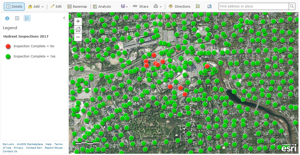
The CEDRA Corporation offers GIS based software for mapping, civil engineering design and modeling, surveying and database maintenance applications. CEDRA’s AVseriesTM suite of software operates directly within Esri’s GIS software (ArcGIS® 9.x and 10.x), thus eliminating the need to switch back and forth between various software packages. CEDRA software is developed entirely in-house and marketed worldwide to public works agencies, tax assessors, utilities, municipalities and private sector companies.

Complementing CEDRA’s Software Development Division is CEDRA’s Professional Services Division which has performed consulting projects throughout the U.S. and specializes in developing, populating and maintaining GIS databases.   CEDRA’s Professional Services Division offers consulting services to clients for a multitude of applications including CEDRA-specific software solutions or can be totally non-CEDRA software related consulting projects. CEDRA staff is highly proficient in GIS Analysis, Data Capture, Data Conversion, Map Production, Routing and Custom Application Development in toth the desktop and server environments.  As an authorized Esri business partner and reseller, CEDRA has a long history in the use and application of Esri’s GIS suite of software dating back to 1987.

CEDRA’s corporate mission is to provide services and software that improves the efficiency and productiveness of its clients. This goal is achieved by (a) developing software that is production oriented and (b) offering services that enable clients to streamline workflows. CEDRA believes the more automated a workflow can be made, the more efficient a client will be and a higher quality product will be produced. CEDRA offers Expertise, Experience and Commitment when undertaking a project.

Illustrative CEDRA products and services include:

Wayne County E911, Lyons, New York

Under this project CEDRA assisted Wayne County staff in developing the County’s E911 street database. Specifically, the work involved acquiring the NYS Street Address Mapping (SAM) data, extracting the street data for Wayne County, and working with the County in verifying and updating the street center line database for use in the County’s E911 system.

In performing this work, CEDRA staff was on-site at the County’s office performing the work and training County staff in the process. A workflow was developed and adopted by the County. Additionally, a training guide was developed enabling County staff to maintain the street center line data with their own resources. Continue reading

Geospatial Business Spotlight: Bowne Management Systems

Company Name:         Bowne Management Systems, Inc.

Location:                     235 E. Jericho Turnpike, Mineola, NY  11501

Website:                      http://www.bownegroup.com

Employees:                 35

Established:               1982

Bowne Management Systems (BMS) is unique in the technology world as the firm has been in business since 1982.   2017 marks the 35th anniversary of BMS and they proudly state “we innovate every day.”

The collective team of professionals are not only fluent in IT and geospatial technology but in the core competencies of any business – professional project management, diverse and adaptable skill sets and most importantly, customer relationships and satisfaction.

BMS is associated with their affiliate, Sidney B. Bowne and Son, a nationally recognized civil engineering and surveying firm that has been in business in New York State since 1895. The shared corporate culture and values has kept Bowne in the forefront for almost 125 years.

BMS has developed core practices to support the mission critical operations of local government. This client base includes local government at all levels, as well as State and Federal government agencies, and private clients. BMS has core practices in the following areas:

  • Public Safety
  • Land Records and Tax Mapping
  • Infrastructure and Asset Management

In addition to these core practices, BMS has robust operations in the areas of IT Staffing and Governance, Geospatial Cloud Deployment, Disaster Recovery and Business Continuity Services, and Project Management and Oversight. Some recent notable work includes the following:

Support for New York City’s emergency  dispatch   systems   – BMS built the street center line (“City- wide Street Centerline” [CSCL]) and the required maintenance  system. BMS also built and maintains  the software that transforms CSCL data to the geofile format required  by the NYPD and FDNY dispatch systems. To date, also most 50 million e-911 calls have been successfully handled by CSCL and Bowne developed software. Continue reading

Geospatial Business Spotlight: Systems Development Group (SDG)

Systems Development Group (SDG)  provides real property, imaging and GIS-centric software and professional services to government, education and private sector companies. The Company provides clients with the appropriate technologies to cost effectively improve tax payer services while reducing operational costs. Clients achieve operational efficiencies with SDG’s blend of expertise in assessment, imaging, GIS and software administration tools and professional services.  SDG currently collaborates with state, county and local government agencies.

Location:             44 Trenton Road, Utica, New York 13502.

Website:             www.sdgnys.com

Email:                   info@sdgnys.com

Phone:                 (315) 798-1328

Employees:        8

Established:       1991

Flagship Product: Image Mate Online (IMO) Real Property Web Portal

The New York State SDG IMO coverage area. Full County services are rendered in blue.  Individual City or Town services are denoted by pushpins.

Brief History

In the New York State Real Property System ( RPS V3) 1990’s era, NYS challenged SDG by noting it was technologically impossible to display photos during a live RPS V3 session.   SDG knew otherwise from similar projects performed for their parent company (Lanier Business Systems). Code being used to add imaging support to hospital applications was leveraged to build an initial application saving the Towns of Whitestown and New Hartford over $50,000 of previously ear-marked monies for Tyler-CLT Landisc street level imaging projects.

As SDG systems engineers and developers grew more familiar with assessment administration, opportunities arose to assist assessors with the development of line of business valuation software utilities including the Assessment Sales Analysis Program (ASAP)  search engine. A combination of these software tools contributed to the successful NYS Office of Real Property Tax Services (ORPTS)  RPSV4  launch.

RPSV4 was originally developed as a client server – “thick” desktop application. However, within a few short years, the internet and web application (browser) paradigm entered the software mainstream. The web quickly became a natural conduit to share real property information with the public and between Government departments and agencies. The next “organic” step forward for SDG was the development of a web portal for real property and assessment information – Image Mate Online (IMO).

IMO quickly gained popularity with NYS Counties and local municipalities throughout the early 2000’s. The State Real Property Tax Administration Technology Improvement Grant Program (RPTATIP) Grant program in 2006 and 2007 helped open the door for many additional County Real Property and Assessment Departments to deploy IMO portals. A large percentage of RPTATIP grant projects included IMO due largely to:

    • Return on Investment (ROI) – The City of Yonkers experienced a 70% reduction in Assessment Office foot and telephone traffic within their first year of IMO operations.
    • Extensibility – Ease of building upon the IMO portal to create “one stop shops” for comprehensive parcel related information.
    • Tight bindings with New York State Real Property and Assessment rules and best practices.
    • Strategic  partnerships, projects and connectivity with “best in class” players including Pictometry, Apex, ESRI, Google, VHB, TerraGo and Sewall
    • Performance and scalability – The Onondaga   IMO site performs over 2 million parcel searches a year. At 20% the size, nearby Seneca County – over 80,000 searches annually.
    • Outpost extends IMO and live RPS data collection services to the field as a low-cost tablet mobile sister service.
    • Continue reading

Geospatial Business Spotlight: Tyler Technologies

Company Name:  Tyler Technologies

Business Unit:    ERP & Schools Division, Transportation Solutions (formerly Versatrans)

Website:               www.tylertech.com

Established:        1966

THE COMPANY

Tyler Technologies, Inc., is a leading provider of end-to-end information management solutions and services for local governments. Tyler partners with clients to empower the public sector — cities, counties, schools and other government entities — to become more efficient, more accessible and more responsive to the needs of citizens. Its mission-critical applications provide the public sector with the ability to streamline and automate operations, resulting in improved productivity, reduced costs and continual process improvement. Tyler’s client base includes more than 14,000 local government offices in all 50 states, Canada, the Caribbean, the United Kingdom and other international locations. Forbes has named Tyler one of “America’s Best Small Companies” eight times, and the company has been included six times on the Barron’s 400 Index, a measure of the most promising companies in America. Tyler provides a broad line of software products in seven main solution areas: appraisal and tax; courts and justice; ERP financial; planning, regulatory and maintenance; public safety; records and documents; and K-12 schools. Tyler has over 400 customers in the State of New York. Customers include large counties such as Nassau, Suffolk and Westchester as well as municipalities such as City of Buffalo, Rochester and Yonkers.

Versatrans started as a transportation planning consulting firm in 1965 and began developing software in 1980. For more than 35 years, Versatrans has developed the leading technology for school professionals to deliver the best service to their districts. In 2008, Versatrans became part of Tyler Technologies, which today employs more than 3,600 professionals. Since that time, the Versatrans® product line has been maintained and supported, and the number of development resources assigned to the product line have nearly doubled. Tyler’s transportation solutions are the software of choice among more than 1,600 school districts and pupil transportation service providers in the United States and Canada. In the State of New York, Tyler transportation solutions are used in over 280 school districts including large school districts such as Buffalo Public Schools, Williamsville Central School District and North Syracuse Central School District, but also in small school districts such as Fort Plain Central School District, Candor Central School District and Broadalbin-Perth Central School District.

PRODUCTS AND SERVICES

Tyler’s transportation solutions are built to factor together district policies and student information with hazard restrictions and realistic bus speeds. This provides safe and accurate bus stop locations and optimal routes that save money. By geocoding with the latest GIS technology using county maps, and taking into account cross restrictions, hazard zones, predator locations and more, the software picks up students from their exact location and assigns them to the safest stop. The Tyler team is composed of industry transportation professionals such as former directors, trainers, routing experts and drivers which, combined with experienced software engineers, apply their expertise and latest technology to transportation solution products, implementation and support.

Tyler’s transportation solutions include Traversa®, the Versatrans suite and Tyler Drive™.

Traversa

Traversa is Tyler’s integrated, comprehensive transportation management system. Traditionally, transportation software has been offered piecemeal, with different interfaces, different data sources and different requirements for training and installation. Traversa offers a seamless user experience for:

  • Bus routing
  • Activity trips
  • Work order tracking
  • Fleet maintenance
  • Automated vehicle location (AVL)/GPS tracking

In addition to the areas mentioned above, Traversa’s core functionality includes entity management (students, vehicles, employees, etc.), messaging and alerts, planning and reporting. Traversa is a cloud-based service supported by Tyler experts and hosted in Tyler’s SSAE16-certified data center. Tyler’s GIS services department converts a client’s data and helps verify client maps. Tyler’s transportation team provides training and data security and – when needed – disaster recovery.


TylerTech1

Traversa Dashboard allows school district transportation personnel to see a comprehensive view of everything they need for routing, planning and fleet maintenance.

Traversa’s technology stack incorporates portions of ESRI’s mapping software and can also interface with third-party data providers to show real-time traffic conditions, construction projects, city planning, evacuation routes, weather and more. A user can select a bus stop and zoom in to inspect the streetscape for possible safety issues. Traversa even helps a user respond to change. If a bridge washes out, he or she can quickly find an alternate path and print the new directions for drivers to use.

TylerTech2

Traversa Routing allows a school transportation router to build daily runs, assign students to stops, generate driver directions, assign vehicles/drivers and more.

Traversa AVL brings all vehicles to one screen for the dispatcher to monitor them in real-time. Users can filter for a specific vehicle, date or time and follow the path of that vehicle. They can also assign geofences for alerts and much more.

TylerTech3

Traversa AVL allows users to view current and historical data related to the location, speed, and direction (N, E, S, W) of the entire fleet of GPS equipped vehicles.

To learn more about Traversa, follow this product overview video.

Tyler Drive

Tyler Drive is an innovative, mobile device designed for the school bus driver.  Mounted on the school bus console, Tyler Drive’s 4G service and cloud-based software closes the gaps in school bus transportation.  It stems the losses caused by outdated timekeeping software and substitute drivers navigating unfamiliar routes. Tyler Drive keeps school buses on course and generates the documentation for reporting and reimbursement.

Tyler6

Tyler Drive Dashboard presents drivers with a comprehensive view of everything they need for their shift.

Through integration with Tyler’s student transportation routing and planning solutions, Tyler Drive is able to provide the most comprehensive and reliable route navigation available. Tyler Drive navigation map highlights the planned route with detailed directions to the next stop. If a road is closed, Tyler Drive can redirect the bus to the planned stop. Driver is presented with turn-by-turn directions and a list of students to pick up or drop off as the bus approaches a stop. If the school bus goes off the planned route Tyler Drive re-routes through the shortest path to the next stop in sequence.

TylerTech5

Tyler Drive live navigation assist the bus driver in getting to all the planned stops, picking up students and dropping them off.

Versatrans Suite

Versatrans is a complete school transportation software suite designed to help school districts efficiently and cost-effectively manage day-to-day transportation needs, transporting students to and from their educational programs on time and on budget.

  • Routing & Planning is a multi-user transportation management system that can effectively handle multiple destinations within the District’s demographics.
  • Versatrans Onscreen® is a GPS fleet tracking solution.
  • Versatrans My Stop™ is a mobile application for parents, guardians and students to know exactly where their bus is and what time it will show up at their stop — all from a smartphone or similar mobile device.
  • Versatrans Fleetvision® is a maintenance software to manage district fleet. It can auto-generate work orders, track inventory and organize employee certifications.
  • Versatrans Triptracker® is web-based field trip software, automates otherwise cumbersome processes like driver selection and personnel approval.
  • Tyler Telematic GPS™ is a hardware solution for school buses providing a complete view of vehicle, driver and engine. Tyler Telematic GPS includes: software expandability, driver scorecard, accident reporting, engine data, real-time alerting and more.

Implementation Services

Tyler’s implementation services include training on software functionality and full map preparation, including entering all district schools with grades, other buildings, walk zones, safe zones, bus stops, bell times and more. Tyler gives many options to keep customer maps current, and when the product receives electronic updates from the original map source, functionality is not affected. Tyler’s maps have the ability to utilize GPS information, draw streets simply and accurately, modify street names, and adjust run times to factors like time of day and school bus speeds. The process is automated to provide both efficiency and safety.

Geotab GPS

Tyler has a long standing relationship with Geotab Inc.; the leader in telematic solutions for heavy-duty vehicles. Tyler has been an authorized reseller for the Geotab hardware since 2010 and its close partnership with Geotab over the years has led to Tyler having the distinction as the only partner to have integrated Geotab data within the K-12 marketplace.

Esri Gold Partner

Tyler is an Esri Gold Tier partner, which enabled Tyler to be an industry-leading provider of geospatial solutions and services. As a Gold Tier partner, Esri recognizes Tyler’s commitment to providing enhanced technical and sales support, collaborative engagement and a national and multinational focus. Multiple Tyler solutions use Esri technology, including suites in school transportation, appraisal and tax, planning, permitting and public safety. Tyler has been an Esri partner for more than a decade.  Tyler’s new K-12 transportation solution, Traversa, is based on Esri technology.

 To find more about Tyler Technologies and their office in Latham, New York, visit their website.

CONTACT

Ted Thien
Sr. Vice President and General Manager, Versatrans
Tyler Technologies, Inc.
23 British American Blvd
Latham, New York 12110
Phone: 800.433.5530 ext. 131840
Email: ted.thien@tylertech.com

Geospatial Business Spotlight: Mapillary

Company Name:                 Mapillary

Website:                              http://www.mapillary.com/

Established:                       2013

THE COMPANY

Mapillary is a new and different approach to Street View. Using computer vision, Mapillary stitches together photos taken with any device to create street-level imagery for extracting geospatial data. By empowering anyone anywhere to easily create street-level imagery, Mapillary aims to create a photo representation of the world. To date, Mapillary’s community has contributed 63 million photos spanning over 900,000 miles across all seven continents.

Mapillary was founded in 2013 by Jan Erik Solem, Johan Gyllenspetz, Yubin Kuang, and Peter Neubauer, who share a vision for putting mapmaking into the hands of people everywhere. Solem, who serves as CEO, previously founded Polar Rose, a facial recognition software that was bought by Apple in 2010.  The company is headquartered in Malmö, Sweden, and has fifteen full-time employees located around the world.   Mapillary’s New York office is based In Brooklyn, NY.

PRODUCTS AND SERVICES

Mapillary allows community members to create and explore a crowd-sourced, street-level view of the world through its app, which is available for web, iOS, Android, and Windows Phone. Users can upload photos from their smartphones or other digital cameras and Mapillary then combines the images together geotagging each using GPS metadata. The resulting 3D reconstruction is created using computer vision and the company’s own open source “Structure from Motion” algorithm. Mapping isn’t limited to streets—the community has captured hiking trails, favorite bike routes, and even a stretch of Antarctica. Mapillary integrates with any mapping platform through simple APIs.

Street-level photos can be captured using Mapillary's iPhone app

Street-level photos can be captured using Mapillary’s iPhone app

In addition to creating photo-maps, Mapillary also utilizes computer vision techniques to extract useful data from uploaded images. For instance, the software can recognize symbols on street signs in photos taken in the U.S. or Europe. This capability grew out of the app’s need to blur faces and license plates for privacy purposes, and is now used by groups like city governments for urban planning, land surveys and asset inventory. Using Mapillary with Esri’s ArcGIS platform has helped cities streamline infrastructure updates, from speed limit changes to road surface quality checks.

Mapillary uses computer vision to automatically detect traffic signs and extract geospatial data

Mapillary uses computer vision to automatically detect traffic signs and extract geospatial data

Humanitarian organizations also use Mapillary to further their initiatives. In Haiti, the American Red Cross and Humanitarian OpenStreetMap partnered with Mapillary to help record previously unmapped areas to aid disaster response efforts. Mapillary has also been used by the World Bank and other groups in Dar Es Salaam, Tanzania, to record infrastructure in flood-prone areas of the city to help plan improvements. The app is ideally suited for these sorts of tasks because it doesn’t require any special equipment beyond a basic smartphone.

Street level imagery is reconstructed by creating point clouds from photos.

Street level imagery is reconstructed by creating point clouds from photos.

Mapillary is free to use for individuals and for non-profit or educational purposes. For commercial solutions, ranging from embedding a photo-map into a webpage to extracting specific data from images, Mapillary has several pricing plans available.

Westchester County GIS is using the Mapillary app to inventory hiking trails in County parks

Westchester County GIS is using the Mapillary app to inventory  hiking trails in Westchester County parks

To find out more about Mapillary, visit their website.

CONTACT: 

hello@mapillary.com
Bredgatan 4, 211 30 Malmo, Sweden
www.mapillary.com