GIS and Mapping Activities at Mohonk Preserve in the Shawangunk Mountains

While traditional trail maps (hardcopy and digital) are still paramount and important, Mohonk Preserve uses GIS for environmental and facility management purposes as well.

 Mohonk Preserve is a nature preserve in the Shawangunk Mountains in Ulster County consisting of over 8,200 acres of cliffs, forests, fields, ponds and streams, and a wide range of unique environmental habitats. It also has over 70 miles of carriage roads and trails for hiking, cycling, trail running, cross-country skiing, snowshoeing, and horseback riding. It is also a major destination for rock climbers in the eastern United States. The Preserve is New York State’s largest nonprofit nature preserve with an estimated 300,000 visitors annually.

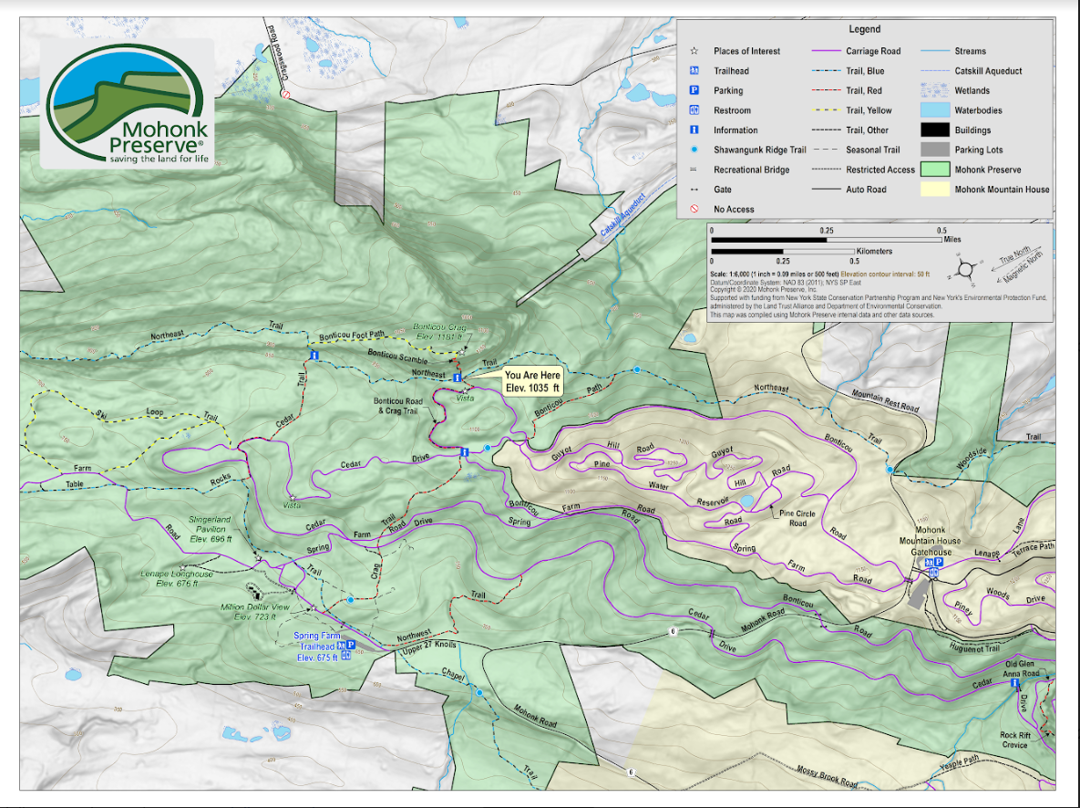
Map making and cartography are still particularly important skillsets at Mohonk
Preserve given the focus on trail use and rock-climbing activities. This is the
wayfinding or locator map that is on the ground (board attached to post) at the intersection of
Crag Trail and Northeast Trail, near the base of the Bonticou Crag Scramble.

Due to its rich biological diversity, New York State’s Shawangunk Mountains (a.k.a the “Gunks”) is one of the most important sites for conservation in the northeastern United States. Because of the many rare natural communities and species found here, the New York Natural Heritage Program ranked the Shawangunks highest in biological diversity. The northern Shawangunk Mountains support 42 state rare species, eight state rare ecological communities, and three globally rare ecological communities in a forested landscape surrounded by residential housing and agricultural uses. Geospatial technologies have supported many government and non-profit-led scientific efforts and studies in the region for years.

Current GIS Applications

Since the early 2000s Preserve staff have been using GIS to inventory and map rare species and habitats in ArcGIS, as well as a wide range of recreational trail maps and related products. Leading the current and most recent use of GIS at Mohonk Preserve is Ed Pestone who serves as Land Protection and GIS Manager. Pestone’s geospatial toolbox includes: ArcGIS client (Map/Pro), ArcGIS Online, Field MapsSurvey 123, and Quick Capture.  Helping support higher accuracy field data collection, support staff also use Bad Elf GNSS Surveyor with real time kinematic (RTKpositioning. For the final rendering of maps and cartographic products, staff use several of the apps found in the Adobe Creative Cloud platform.

In recent years, Pestone and the entire Preserve staff have embarked on a major redesign of the preserve-wide map which was a nearly 20-year-old, hand drawn map by artist Jack Fagan. While still functional, the Fagan map was missing several elements both staff and visitors felt needed to be included in an updated map. Approaching the update with a focus on “wayfinding” – in both the hardcopy and digital format – the new map would include new trailheads, new lands acquired by the Preserve, emphasize and better symbolize elevation, and be a product which could be used at trailheads and widely distributed (color and greyscale versions). It was also hoped and intended that the new map would reduce the number of lost hikers. It was an incredibly comprehensive and inclusive redesign effort which is documented in this Hudson Valley online news journal article. A more comprehensive overview of the project is included in the YouTube video from a 2021 inhouse webinarA geo-referenced version of the new map is available for the Avenza app which can be accessed using this link.

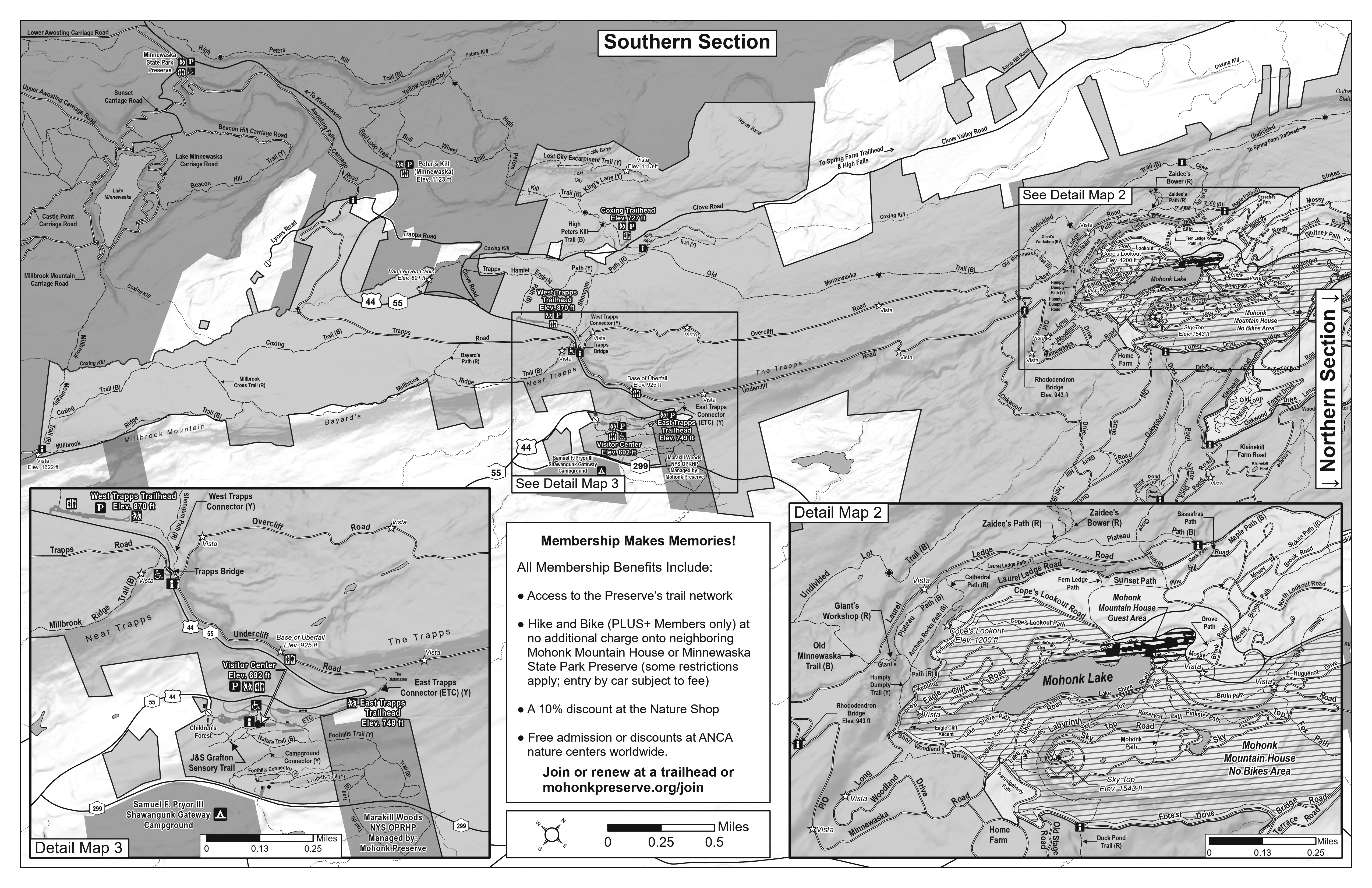
At the request of Preserve Rangers, redesign of the new map included the production of a
greyscale fold-up version which is broken into a “Southern Section” on one side and a Northern Section” on the other (not shown). Rangers wanted an easy to reproduce map that could be given out for free on the trails to hikers and other recreationists.

Geospatial Data

The Preserve data catalog includes an extensive range of both
natural/environmental, cultural, and human-made geographic features. Mobile data collection efforts have collected built environment datasets such as culverts, bridges, signage, waterbars, trailheads, buildings, and parking lots. A majority of this current data was collected in Field Maps by our 2021 Scheuer Intern. The Preserve's carriage roads/trails (as well as the Preserve boundary) are publicly available on ArcGIS Online, they are also both on ESRI vector basemaps through the Community Maps Program. Environmental datasets include forest types (including forest health plots) protected lands, deer and land management units, and significant habitats/species (contributed by both NY Heritage Program and Preserve staff). GIS mapping has also been used to document the locations of rock shelters, historic building foundations, and burial grounds, as well as in support of mapping (courses, mile markers, and aid stations) for special events
such as the Shawangunk Grit. Just a sample of the man-made features mapped at the Preserve include, but not limited to, 356 interpretive signs, 288 trail/directional signs, 290 culverts, 43 gates, 156 waterbars, and 148 traffic/parking signs among others.

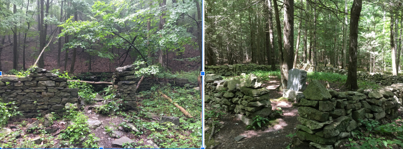
Two of the many man-made and cultural features inventoried in the Preserve using ArcGIS Field
Maps by seasonal staff: historic building foundations (left) and cemeteries (right).

Local data such as parcel, surface water, and zoning datasets are
obtained from Ulster County GIS.  GIS work at the Preserve also
leverages data from many sources including the NYS GIS Clearinghouse, NYS Dept. of Environmental Conversation, NYS Office of Parks, Recreation and Historic Preservation, as well as CUGIR at Cornell University, U.S.G.S (national wetlands inventory, National Hydrology Dataset [NHD], and digital elevation data), the Nature Conservancy, and Scenic Hudson. Quite a list.

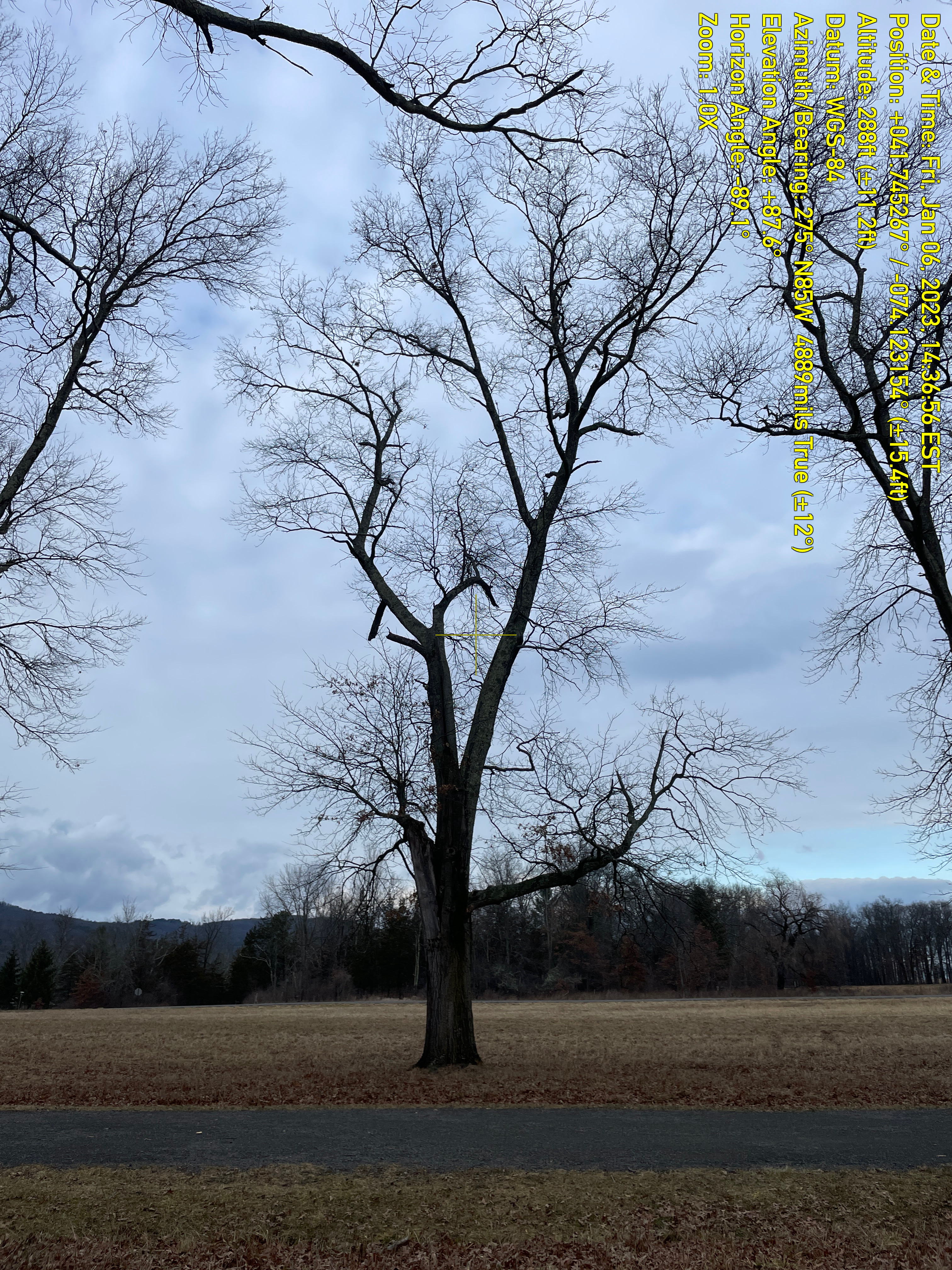
Pin Oaks (Quercus palustris) are an important tree species on the Preserve often bordering some
of the most historic carriage roads. Many of the oaks along carriage roads are at or nearing
their general life span. The Preserve has mapped the location of the Pin Oaks monitoring and
documenting the condition of trees at least once annually (leaf off for photos) using Field Maps.
Work such as cabling, pruning and removing some of the trees is involved in the management
program.

Summary

“Mapping and GIS are integral parts in all aspects of managing the built and natural environment at Mohonk Preserve” notes Pestone. He adds “In the future we see expanding use geospatial technologies by both seasonal and full-time staff and with our collaborating agencies. I anticipate no shortage of uses and applications.”

Contact:

Ed Pestone
GIS and Land Projects Manager
Mohonk Preserve
epestone@mohonkpreserve.org


Hard Copy Maps Still Rule: NYS Agricultural Districts

The art form is still alive as counties design and create maps as part of the Agricultural District Certification process

I’ve written about agriculture in New York State before in context of the farming community continuing to evolve with the adoption of geospatial technologies. With farmland covering nearly 20% of the state’s geographic footprint, its easy to see why geospatial tools are so increasingly important in managing the state’s prime agricultural lands.  And one does not need to look far to see the advancements of new geospatial technologies in New York State agriculture, particularly with the recent Systems and Technologies for Remote Sensing Sensing Applications Through Unmanned Aerial Systems (STRATUS) conference May 23-25, 2022 at SUNY ESF in Syracuse. Several papers and even dedicated tracks of papers and presentations focusing on UAV/drone technology in agriculture.

And it’s big business, too. A November 2021 article published by NY Business Agribusiness Column: Economic Impact of Agriculture in New York State stated that “agriculture in New York State contributed $43.6 billion in total industry output, 160,100 jobs and $12.3 billion in gross domestic product across the state economy.” It’s a rather amazing article with many more figures on how agriculture impacts the statewide economy, The article is based on the work and research of Todd Schmidt, an associate professor with the Charles H. Dyson School of Applied Economics Management at Cornell University.

Which makes it all the more interesting in 2022, even with the fledgling agritech applications and the almost complete conversion and automation of our mapping, cartography, and business/financial systems, the certification of agricultural districts in the state still involves the use of an iconic piece of mapping and cartography: The hardcopy map. Yes, while the digital data/products in producing the hardcopy maps are used and repurposed in many useful and productive ways across the state, it is still the hardcopy map which is used as part of the agriculture district certification process by NYS Department of Agriculture and Markets (AgMkts).

Background

Since 1971 , the Agricultural Districts Law, Article 25AA of the Agriculture and Markets Law (AML), as administered through (AgMkts), has reflected state and county level efforts to preserve, protect and encourage the development and improvement of agricultural land for the production of food, fiber and other agricultural products. As districts are created, or modified during renewal, maps are generated, based on tax parcels included in the districts. Each county is responsible for creating maps to meet the requirements of the Agricultural Districts Mapping Program. Supporting AgMkts in this regard is Cornell University’s Institute for Resource Information Sciences (IRIS) has helped facilitate the mapping program since 1977. Its primary responsibility is to support agricultural district mapping efforts by reviewing, distributing, and archiving agricultural district maps, and to provide consultation services. Automation of the statewide district maps began in earnest In 1996 when the entire set of NYS Agricultural District maps in the collection of Cornell IRIS (formally CLEARS) was converted to digital format. This was done by shipping blueprint copies of the maps to the NYS DEC for scanning.

Article 25AA references maps several times in Section 303 as a required deliverable for certification of a district. Specifically the text includes “The district review plan shall include a description of the district, including a map delineating the exterior boundaries of the district which shall conform to tax parcel boundaries”Agricultural districts across New York State are reviewed and certified on an eight-year cycle.

The Map

It’s a real treat anymore to show up at a meeting or discussion and be given the chance to review a traditional, well designed hard copy map. Increasingly becoming rarer and rarer. And just think how much less demand there would be for hardcopy maps if it wasn’t for the ubiquitous use and sharing of the PDF file format? For so many years, the 1:24,000 map was one of the most commonly used map design and layouts following in step with the classic U.S. Geological Survey 2000-scale quadrangle grid series. And yes, it just so happens the required base map standard for the agricultural district maps, as outlined in the Agiriculture Districts Program Mapping Checklist prepared by IRIS, is 1:24,000. According to Diane Ayers, who provides staff support to the mapping program, “IRIS recommends either the NYS DOT 7 ½ minute planimetric map series (available in either raster or vector format) as the base map for individual County mapping products.

The 32-page document consists of written requirements covering topics such as, but not limited to, map content including roads, civil boundaries, and water features, as well as traditional map items such as north arrows, keys and legends, scale bars, and the bounding geographic coordinate grid.  Documentation on the source of base map data, other data layers, year of parcel data, and geographic reference information (datum, projection, etc) is also recommended.   It also includes several pages of examples covering a wide range of other hardcopy cartographic principles including annotation, color selection, and symbology.  Many items which cartographers and map makers have greater flexibility in controlling when using desktop client software vs. web mapping cartographic tools. 

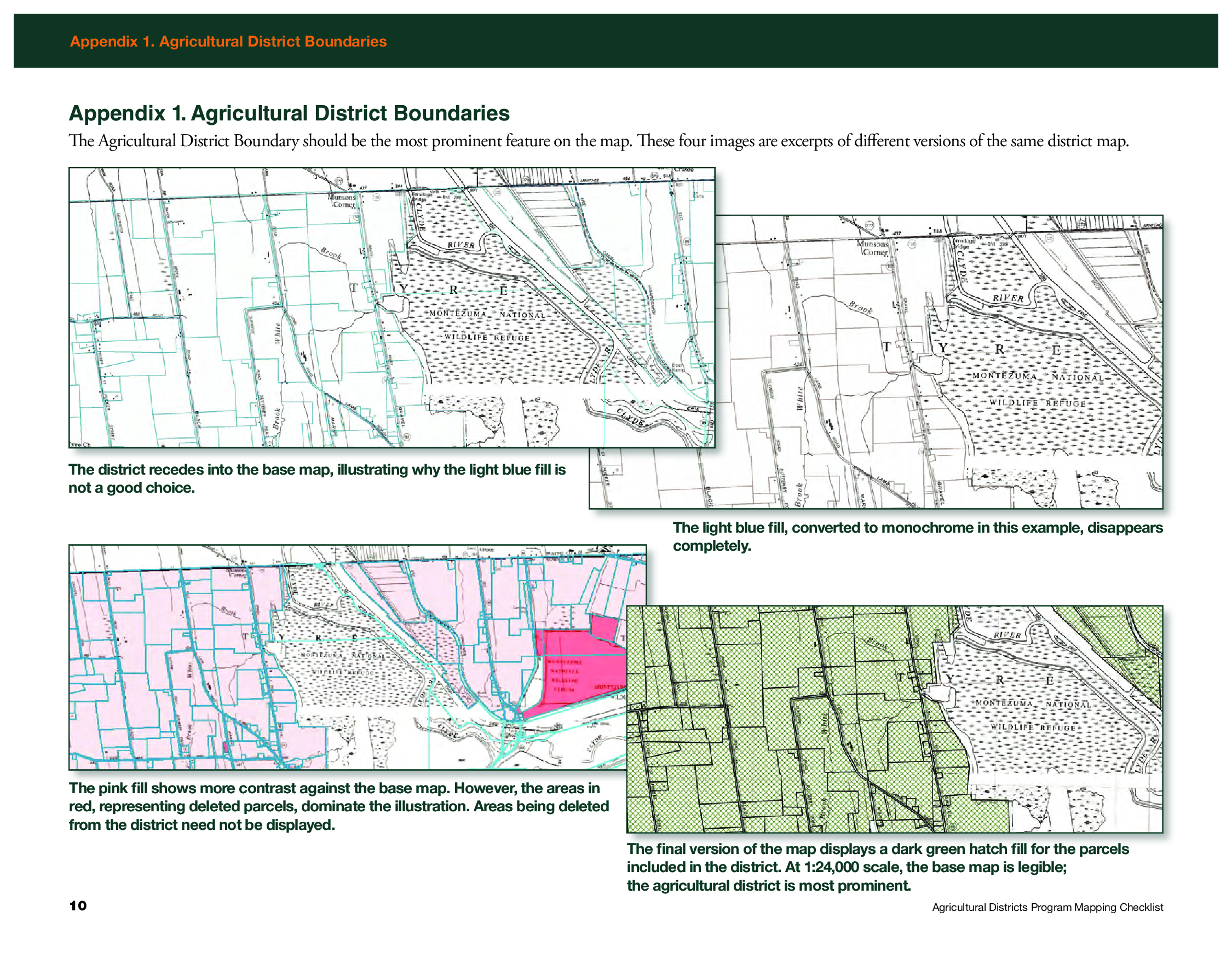
Appendix 1 in the Mapping Checklist document shows examples of how to render the district boundary as the most prominent feature on the map

While counties send all review materials associated with the eight-year review, including tax parcel information, directly to AgMkts, the county produced hardcopy map and shapefiles are sent directly to Ayers.   She reviews the maps for consistency with the mapping checklist and then forwards to AgMkts and uses the shapefiles to maintain a consistent a set of statewide district maps which are available via CUGIR.  The statewide coverage she maintains based on this relationship and data exchange with the counties can be found here.

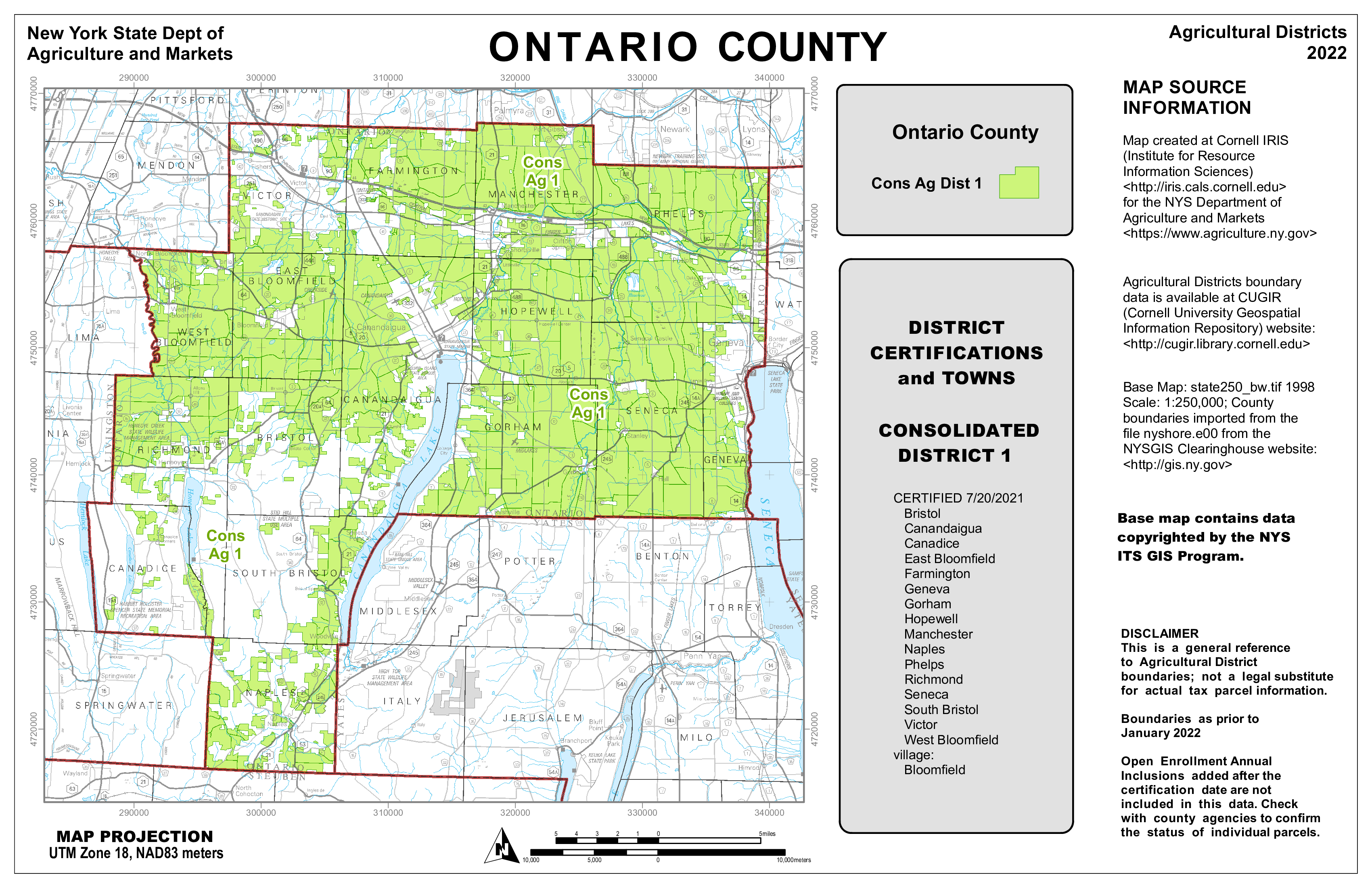
The 2022 Ontario Agriculture District Map as produced by IRIS. Shapefiles and documentation received from counties enables IRIS to maintain a statewide agricultural district coverage.

Sheri Norton is the GIS Coordinator for Ontario County, located in the Finger Lakes region renown for viticulture and other agricultural products. She has been through three district reviews including a large countywide consolidation in 2021. “Agriculture District mapping is a big effort with partnership between our Planning, Real Property and GIS Program staff”, she says, “but with my previous experience in producing the mapping products for IRIS and becoming more comfortable with ArcGIS Pro, the map series and formal reports are now easily updated for the next review cycles.  The ArcGIS client is all I use.”   Which is quite an accomplishment, as keep in mind many final cartographic products are often “touched up” before final publication with other desktop publishing software such as Adobe Illustrator. The certification also includes generating a list of all tax parcels in the district(s) based on the county assessment roll.

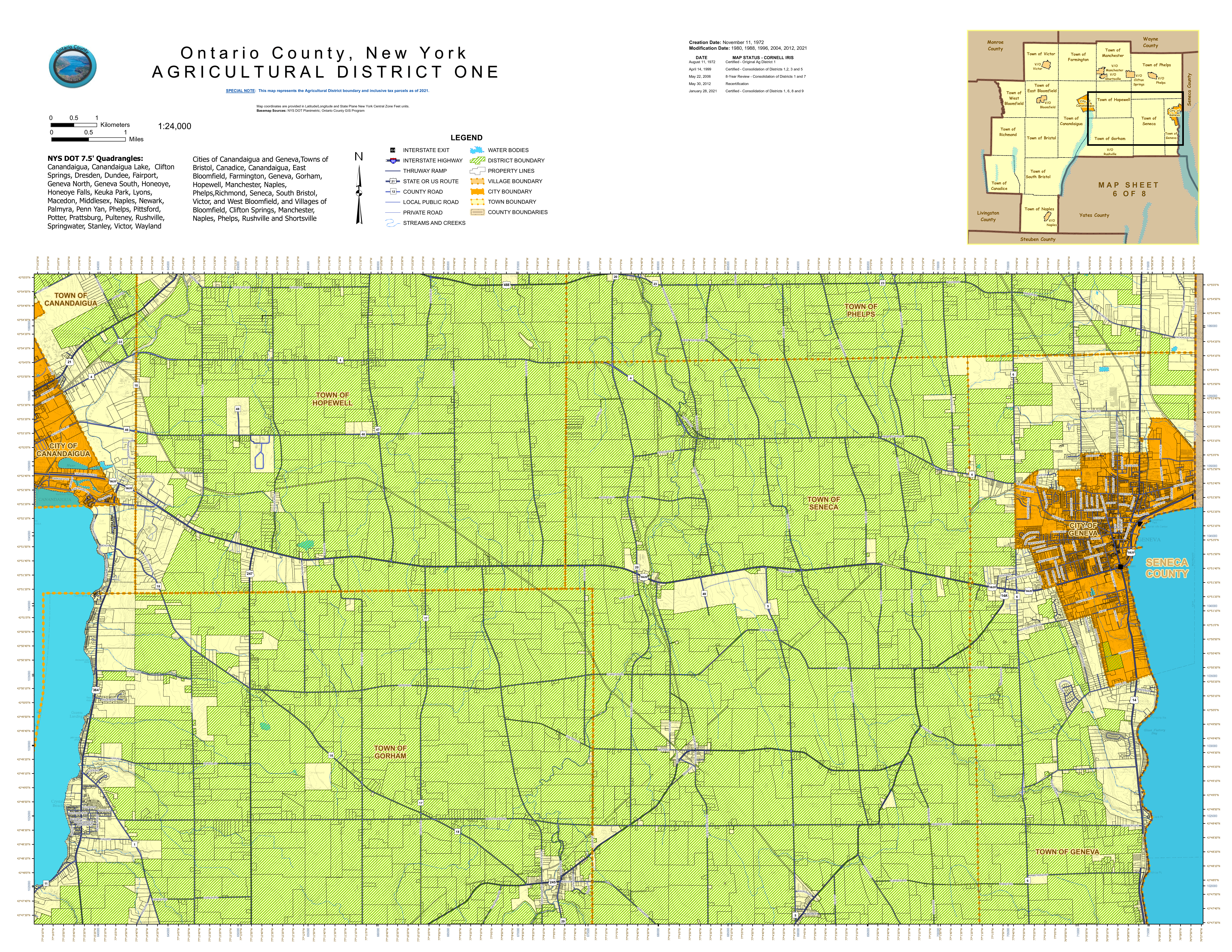
Sheri Norton’s 2021 Ontario County Agriculture District One map designed and produced entirely with desktop GIS software.  This same map was provided to AgMkts as part of the review and certification process

Summary

Hard copy maps are as close to GIS comfort food as we can get.   And here in New York is refreshing to see how this important piece of our cartography past is still being used in a government regulatory program.  Holding its own against all of the advancements – and acceptance of digital web mapping.  Kudos to GIS professionals across the state who are still producing hardcopy maps and helping the product remain relevant as part of the profession.

Agricultural Districts protect and promote the availability of land for farming purposes.  For informative overview of this important Empire State Program review this presentation.

Contact

Diane Ayers
Data Manager and Educator
NYS Agricultural Districts Mapping Program
Cornell IRIS
1015 Bradfield Hall
Ithaca, NY 14853
dag10@cornell.edu

Sheri Norton 
GIS Coordinator, GISP
Geographic Information Systems Program
Ontario County Information Technology Department
70 Ontario Street
Canandaigua, NY 14424
Sheri.Norton@ontariocountyny.gov

Jeff Kehoe 
Farmland Protection Specialist
Department of Agriculture and Markets | Division of Land and Water Resources
10B Airline Drive
Albany, New York 12235
jeffrey.kehoe@agriculture.ny.gov

Campus Planning and Geospatial Technologies at UAlbany

GIS used in many areas alongside engineering and architectural applications

College and university campuses are the home for a vast amount of geospatial data covering both the natural and built environments.  Whereas at the beginning of geospatial era there was a clear and defined digital divide – GIS vs. CAD –  today these technologies have evolved to be used and managed together almost seamlessly.  In this space since the early 2000’s we’ve seen the evolution of the Building Information Model (BIM) in along with drone, GPS, and laser scanning technologies serving as a means to capture and generate additional types of geospatial data both indoor and outdoor.  GIS concepts are also important elements integrated into Enterprise Asset Management (EAM), Computer-Aided Facilities Management (CAFM) and Computerized Maintenance Management System (CMMS) solutions.

Built around the geospatial framework which also includes standards for both data collection and data management, GIS applications in campus settings are leveraged by both GIS specialists and engineers alike.  Common program areas include covering areas such as master plan support, space programming, work order management, asset management, emergency management, real estate and portfolio management, environmental and regulatory compliance, and site selection studies among others.

While traditional GIS and engineering software applications such as ArcGIS and AutoCAD support much of the outdoor mapping, facility managers increasingly use a more indoor specific software programs such as Revit, Autodesk BIM 360 Ops, Cartegraph, and ESRI’s relatively new entry into this space ArcGIS Indoors, among others.   In reality, automated systems at large facilities involve a combination of the programs noted above and often also integrate other monitoring and SCADA systems.   If you are new to GIS and geospatial applications to the campus setting, here is a good overview presentation.

Campus Planning at UAlbany

Many of these geospatial-related disciplines intersect directly – and indirectly-  in the Office of Campus Planning at UAlbany which is charged with the overall planning of physical space on campus (indoor and outdoor), capital and operating funding, and supporting the strategic plan of the University.   The office currently has a team of eight which includes Jessie Pellerin who serves as GIS and Signage and Wayfinding Manager.

Jessie is involved with several elements of GIS data collection and cartographic products associated with the UAlbany facilities for the uptown, downtown, and Alumni Quad campuses – including the production of hardcopy maps which are still an important communications and outreach component for visitors and students new to campus.   Nearly all of her day-to-day work is done with ArcGIS Pro.  Field data collection is normally supported with Collector for ArcGIS on an iPad and for offline viewing.

Jessie produces all of the UAlbany maps using just ArcGIS Pro without the use or addition of any desktop publishing software

With regard to above and underground features on, the 500-acre uptown camps, she helps manage a GIS database which includes 122 emergency blue light phone locations, 16.5 miles of storm sewer pipes and 760 catch basin, 6.4 miles of sanitary sewer pipes, 1500 light poles and 12 miles of roads among dozens of other features. Jessie also oversees individual data collection projects conducted by vendors such as the campus wide light poles and irrigation system.   She serves as the ArcGIS Online Administrator for the Office supporting and maintaining several customized viewers for 50 staff across campus in specific work program areas.

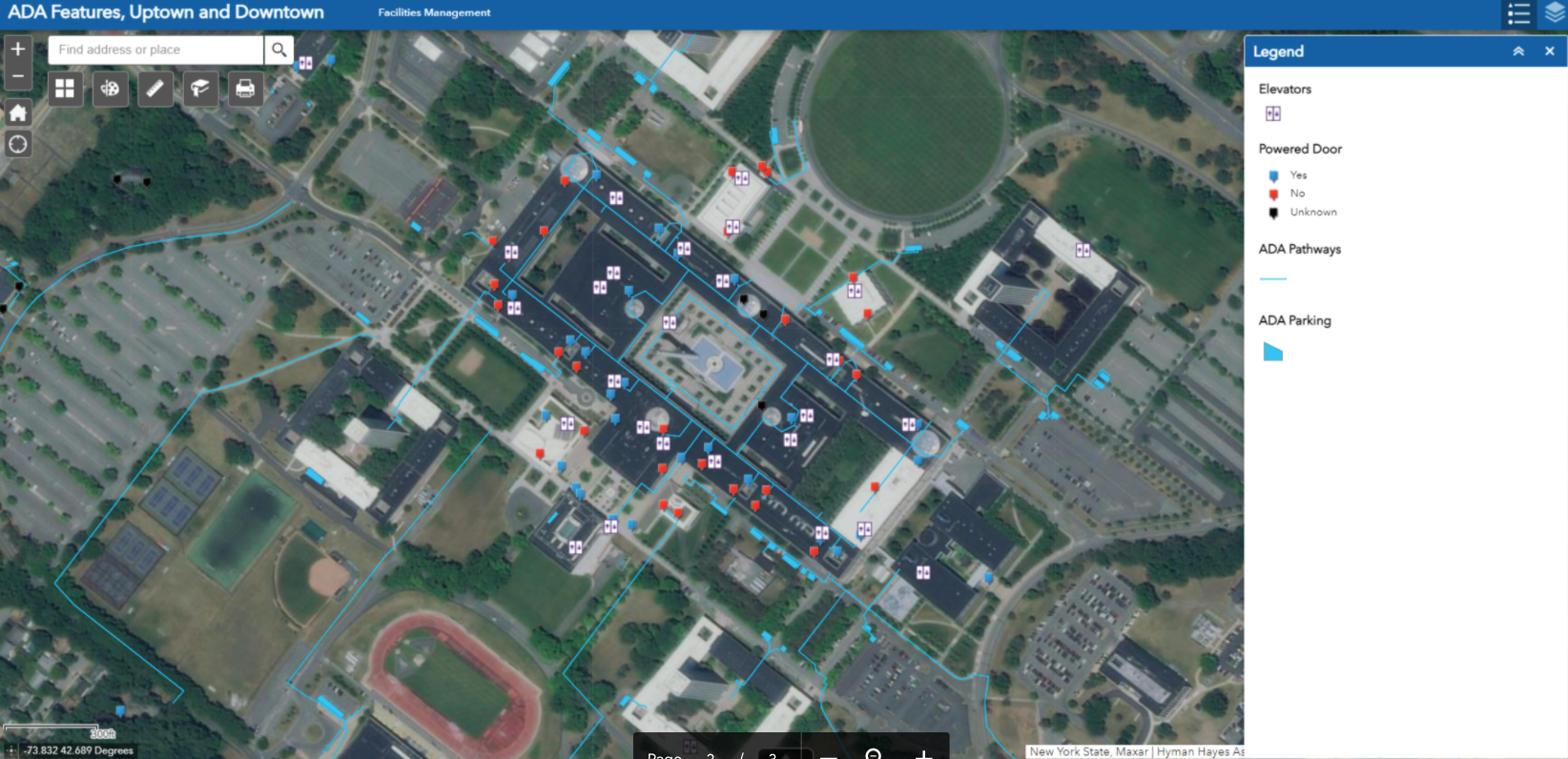
One of internal AGOL viewers Ms. Pellerin supports focuses on the locations of accessibility features on the Uptown and Downtown Campus. Pop-ups include more information for each feature. Data was developed from a campus-wide accessibility study.

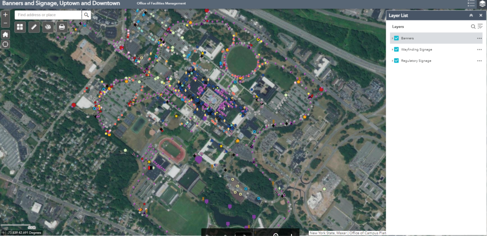
Another viewer shows the location of the exterior wayfinding and regulatory signage and banners on campus. With over 500 exterior wayfinding signs, 750 regulatory signs, and 550 banners, GIS has been essential in keeping track of sign content and condition for aiding in preventative maintenance, site planning, and branding initiatives. Both of the above viewers were built with Web App Builder.

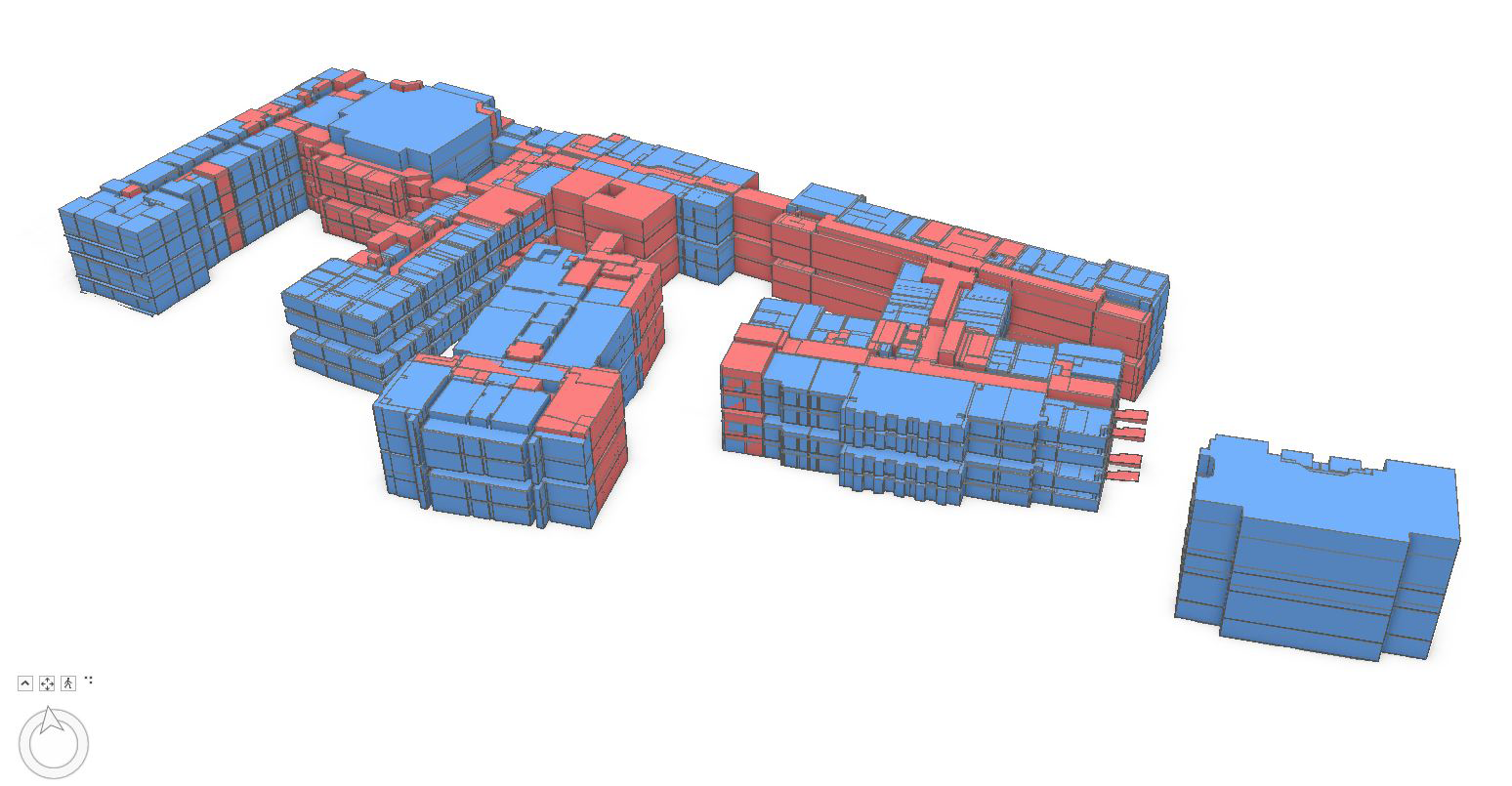
An example of how space planning is supported using GIS at UAlbany. This graphic shows a 3D visualization of assignable space on the Downtown Campus

As part of supporting the university’s COVID-19 response, Jessie assisted with others by using combining mapped sewer line and manhole data with the occupancy count of each of the residential dorms, to determine the optimal locations for the waste water testing sites in 2020. There ended up being six manholes selected (out of the 282 on campus). Maps were shared with other stakeholders in the project.    

As it relates to campus settings, GIS use is growing and being used more often in buildings and facilities planning by campus staff” notes Stu Rich, Director, Buildings and Infrastructure at Cartegraph.  Initially, as outdoor GIS concepts and technology were beginning to be applied to the indoor environments, cost was often a barrier to get started in building BIM and interior models for many organizations.  “Those barriers are beginning to change” Rich further adds, “While precision indoor mapping will always require higher-end instrumentation, recent products such as MagicPlan and IndoorVu, as well as falling software prices, are making interior mapping and data capture more affordable for large facilities management programs.   All of these products and technologies are now broadly used in facilities management and integrated with GIS applications.”

Recognizing the importance and growth of using digital data both in-house and with the numerous engineering companies performing work on campus, both the Office of Campus Planning and the Office of Architecture, Engineering, & Construction Management (AECM) have developed digital data standards for BIM, GIS, and AutoCAD.

Summary

Large campus facilities such as SUNY Albany bring together the intersection of several geospatial technologies.  Individually each seemingly used or applied for one specific purpose (and often at varying levels of spatial accuracy) but when mashed together in a just web viewer, provide easy access to a wide range of authoritative digital content for decision-makers. Sure signs of the growing maturity and acceptance of geospatial technologies.

Contact:

Ms. Jessie L. Pellerin
GIS and Signage and Wayfinding Manager
Office of Campus Planning
University at Albany, State University of New York
jpellerin@albany.edu

Geospatial Technologies at St. Lawrence University

The 2017 New York State GeoCon in Lake Placid provided the opportunity to for me to catch up with several statewide colleagues which will be reflected in at least a couple upcoming blog posts.  As part of these discussions, I ended up connecting with a familiar Empire State GIS person of interest:  Carol Cady – who serves as GIS Specialist/Map Librarian at St.Lawrence University (SLU) in Canton, New York.  Our discussion and follow-up communications certainly highlight a wide range of geospatial activities in the state’s North Country which the SLU GIS program is a significant contributor.

Carol directs the GIS project which is housed in the Libraries and Information Technology Division.  Unlike many of the New York State public university geospatial programs, the SLU program is not associated with a specific academic curriculum or major.  She and other GIS program staff provide instructional, technical and research geospatial support to the entire university community in the use of geospatial software and technology including Remote Sensing and Global Positioning Systems (GPS).

Carol arrived at SLU in 2002 to oversee and manage the GIS program.  Before her arrival, the SLU GIS program had been established in the early 90’s by Professor Bill Elberty who was a Geography Professor and for whom the current GIS lab is named after.  Professor Elberty taught GIS courses which provided the foundation for many current GIS professionals across New York State.  After Professor Elberty retired in 1999 the GIS program data and software was moved to the Science Library.

Prior to accepting the SLU position, Carol served as a GIS Analyst for Fort Drum Natural Resources Branch as a contractor. Carol’s background is in biology with a BS from UMass- Amherst and a Masters in Zoology at the University of Vermont.   She was introduced to GIS as land management tool while a seasonal wildlife technician for US Fish & Wildlife Service at Moosehorn Refuge in Calais, ME.   She then returned to UMass to learn more about GIS with coursework in the Wildlife Department.

GIS Facilities and Academic Offerings

The principal location for GIS and GPS instruction at SLU is the Elberty Laboratory for Spatial Analysis.  The lab includes 15 dedicated GIS workstations, printing and plotting devices, field tablets, and both Trimble and Garmin GPS units.  Increasingly, smartphones using the ESRI Collector and Survey 123 apps are being used in field data collection efforts.  Both Carol and GIS/GPS technician Dakota Casserly offer support to the SLU community in a variety of software packages including ArcGIS, QGIS, Google Earth, IMAGINE, IDRISI, and NASA’s WorldWind.

On a regular basis, Carol teaches both Intro to Geographic Information Systems (with lab) and Directed Studies in Geology GIS classes and occasionally Advanced GIS and Intro to Geospatial Technologies.  GIS concepts are incorporated in other courses in the areas of Conservation Biology, Global Studies, Environmental Psychology.

Carol is assisted by Dakota Casserly, St. Lawrence University GIS/GPS Technician who is involved in the program on many levels including designing and guiding projects with student GIS technicians and teaching introductory sessions or specialized topics like GPS and Network Analyst.  A project he has recently completed is the Laurentian Legacy project.

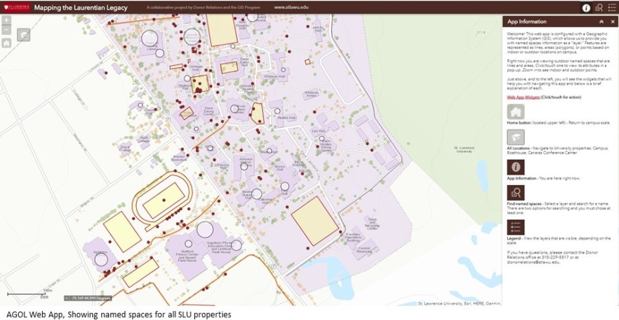
Mapping the Laurentian Legacy is a partner project between the University’s Donor Relations department and the GIS Program. The web app provides interactive and searchable access to the University’s named spaces database.

Projects and Activities:

The GIS program at SLU provides support to many local and regional geospatial efforts.  The program has a long  relationship with the St. Lawrence Land Trust having provided maps for base line and yearly evaluations of easements.  Recently, SLU GIS staff, along with Jess Rogers, Assistant Professor, Biology/Environmental Studies, SUNY Potsdam, and Alex French, Sustainability Coordinator, Clarkson University conducted a suitability analysis to find large privately owned forested properties which meet Land Trust criteria to put lands into a protected easement.  More recently, Carol’s Intro to GIS has been involved in a suitability analysis to identify non-forested properties in all of St. Lawrence County that may meet Land Trust easement criteria.  In 2013 Dakota’s predecessor, Jonathan Ignatowski, worked with the St.Lawrence County Health Department to identify houses built before the early 1970s and may contain lead paint.  This was part of a larger project to help with lead paint remediation for household owners.

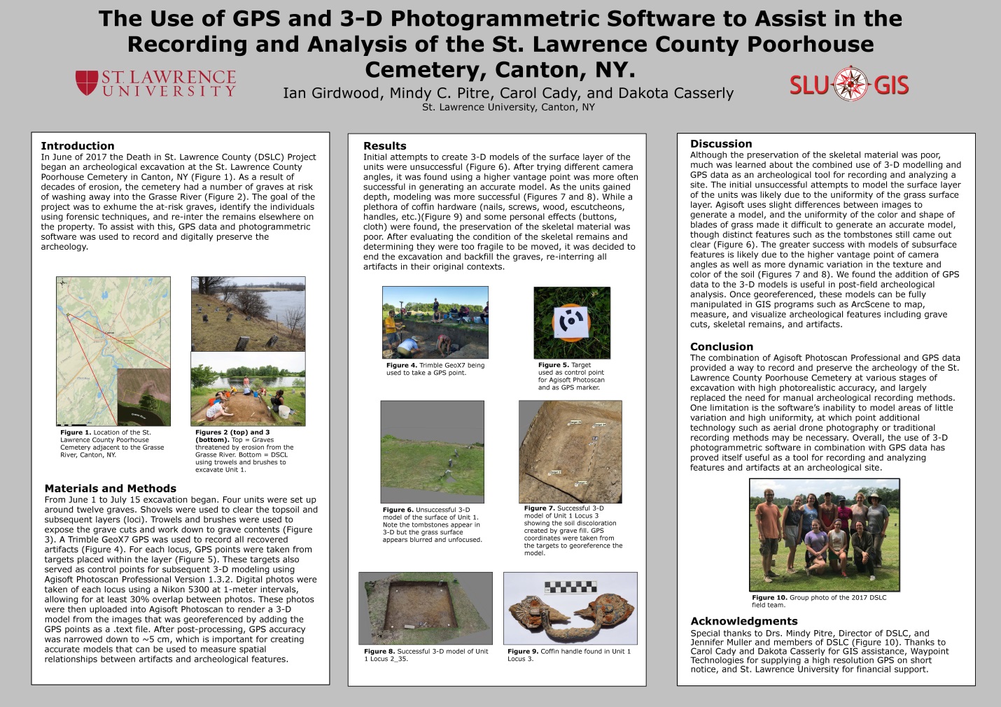
One SLU project which was of particular interest to me is the June 2017 Death in St. Lawrence County (DSLC) Project that began an archeological excavation at the St. Lawrence County Poorhouse Cemetery in Canton, NY.  As a result of decades of erosion, the cemetery had a number of graves at risk of washing away into the Grasse River.  While the original goal of the project was to identify and exhume at-risk graves, identify the individuals using forensic techniques, and re-inter the remains elsewhere on the property. Unfortunately, Mindy C. Pitre, an assistant anthropology professor at St. Lawrence University, who was overseeing the project said she and her team of students discovered that very little remained of the bones at the gravesites they dug closest to the Grasse River.  As a result, the bone could not be examined and information such as gender and age could not be determined, she said. The deteriorated bone fragments were returned to where they were found and reburied.  It was felt that continuing any further would have done more harm than good by removing it, so the project was stopped.  Nonetheless, the project did include the use of state-of-the-art geospatial tools including high resolution GPS data and 3-D photogrammetric software to record and digitally preserve the archeology. This project was presented as a poster at the Lake Placid conference.

Additional examples of student projects focusing on American Kestral nesting sites, Brook Trout spawning sites, wind turbine placement relative to hawk migrations, and the effects of St. Lawrence County land use changes on grassland bird habitat can be found on the SLU GIS landing page.

Working Partners:

Collaborating organizations in the North Country recognize SLU’s GIS contribution in regional geospatial efforts.  Notes Jason Pfotenhauer, Deputy Director. St. Lawrence County Planning Office:

“The St. Lawrence County Planning Office has had a long relationship with the GIS lab at St. Lawrence University having worked with Carol Cady for many years, as well as several of her mapping technicians.  We traveled to numerous State GIS conferences and NYS geo-spatial summits together and have had approximately 10 SLU students work with our office in various capacities.  Two recent larger scale county projects were the result of Carol’s willingness to supervise graduating seniors with strong GIS skills.  For the first, Carol took the initiative to pursue Walker Fellowship funding so that Sean Gannon could receive a paid internship and create the initial dataset for the County’s Agricultural Atlas.  The second project involved the collection of raw U.S. Census data to depict housing and socioeconomic data at the census tract level (which is not readily available on existing regional, state or federal websites).  Dylan Arpey undertook this initiative to help inform the County’s Assessment of Fair Housing.

The GIS lab staff have also provided us with valuable technical assistance that improved our capabilities in preparing maps for county constituents.  Most recently Dakota Casserly and Carol provided a tutorial on how to geoprocess tiffs in order to create digital models of hard copy flood plain maps.”

Star Carter, GIS Supervisor, Development Authority of the North Country (DANC) adds:

“The St. Lawrence County university/college GIS people are all fantastic and very worthy of recognition!  I work with the SLU crew a few times a year to get data or share data for infrastructure in the Village of Canton.  It’s a good relationship.  DANC has hired graduates and summer interns from both SLU and SUNY Potsdam.  A former DANC GIS Specialist graduated from SLU and is now in grad school in Colorado; and a current DANC GIS Technician graduated from SUNY Potsdam.  All of these graduates came out of their programs with enough GIS skills and practical experience to hit the ground running and be valuable employees right away.  So, from the hiring perspective of a local employer, having these GIS programs available at local universities is very important to keeping me supplied with a competent workforce”.

Summary

The St. Lawrence University GIS program illustrates the growing presence – and importance – of the New York statewide network of university programs which support regional and local GIS initiatives.   In absence of paid consultant assistance, University programs can often provide a certain level of geospatial support to governments and organizations with limited funding or geospatial capacity.  While several Empire State college programs offer both B.S. and advanced degrees in geospatial technologies, non-degree academic programs such as SLU offer high quality geospatial academic training, combined with applied field experience that adequately prepares students for a variety of geospatial workforce occupations.

For more information on the St. Lawrence University GIS Program, contact Carol Cady at ccady@stlawu.edu.


The Federal Geospatial Data Act of 2015: A NYS Local Perspective

There has been a limited amount of fanfare and support – or even discussion for that matter – here in the Empire State on the proposed Geospatial Data Act of 2015.    Beyond one or two acknowledgements on  the state listservs, the announcement really didn’t generate any buzz or visible discussion throughout the GIS community.   Though it comes as no real surprise as few in New York statewide GIS community have had any meaningful exposure or introduction to past legislation/bills regarding federal agencies referenced in the proposed 2015 act introduced by Senator Orrin Hatch of Utah.  In absence of any real meaningful dialog here in the New York  between the GIS professional community and elected officials on federal legislation (or any geospatial legislation for that matter except perhaps the never-ending “Surveyor” Legislation), one wonders if New York’s federal delegation is even aware of the proposed act.  Or its stated benefits.

At the core of the proposed 2015 Act is a combination federal legislation and policies including (in no particular order of importance) OMB Circular A-16, the National Spatial Data Infrastructure (NSDI), and the Federal Geographic Data Committee (FGDC).   Very government-like and uber confusing, a little background includes: In 1994, Executive Order 12906 was issued by President Clinton to direct the development of the NSDI.  Unfortunately, twenty-one years later,  many of the requirements of EO 12906 have never been acted on.  Circular A-16 was originally issued in 1953, revised in 1967, revised in 1990 (establishing the FGDC), and revised again in 2002 outlining specific federal agency obligations.  A-16 Supplemental Guidance was also issued in 2010. Similar to EO 12906, federal agencies have struggled to implement many of the provisions of OMB A-16 over the same period of time.

The August 2002 revision to Circular No. A-16 was particularly significant in context of naming the stewardship of over 30 data themes to federal agencies in support of both the NSDI and FGDC programs.  Specific datasets included:

 Biological Resources, Cadastral, Cadastral Offshore, Climate, Cultural and Demographic Statistics, Cultural Resources, Orthophotography, Earth Cover, Elevation Bathymetric, Elevation Terrestrial, Buildings and Facilities, Federal Lands, Flood Hazards, Geodetic Control, Geographic Names, Governmental Units, Geologic, Housing, Hydrology, International Boundaries, Law Enforcements Statistics, Marine Boundaries, Offshore Materials, Outer Continental Shelf Submerged Lands, Public Health, Public Land Conveyance, Shoreline, Soils, Transportation, Vegetation, Watershed boundaries and Wetlands.

While all data themes are clearly important in supporting the broad national NSDI efforts, most New York State local governments  have a limited number of day-to-day business work functions directly related to NSDI spatial data themes itemized in the 2002.  (In fact many of the 2002 NSDI spatial data themes are only developed and maintained by federal resources.)  Adding to the disconnect is that many 2015 local government GIS programs, especially in urban areas, have business needs which are not supported by either the content or spatial accuracy of core 2002 NSDI spatial data themes.  For example, local government geospatial programs in the areas of  infrastructure management (drinking water, sanitary sewer, and storm water systems), utilities, vehicle routing and tracking, permitting and inspection systems, service delivery programs in the health and human services, local planning, zoning, and economic development activities are not closely aligned with many of the 2002 NSDI spatial data themes.    While many federal mapping programs and geospatial datasets continue to be consistent at 1:24,000 (2000 scale), most local urban government GIS programs are built on top of large scale (i.e., 1”=100’ or even 1”=50’) photogrammetric base maps.

Not all is lost, however, as some local data products such as parcel boundaries and planimetrics (building footprints, hydrology, transportation) actually are consistent selected 2002 NSDI spatial data themes (Cadastral, Governmental Units, Hydrology, Geodetic Control, Transportation) albeit at a higher degree of accuracy.  Unfortunately, limited capacity or systems have been established to leverage or normalize such datasets into the NSDI.

Unfortunately, even though the federal government continues to identify and list local governments as key stakeholders in most legislative proposals, it’s common belief among federal agencies that resources are not available to monitor or engage local GIS programs (i.e., 3000 counties vs. 50 states).  And there continues to be the (wild) belief state level GIS programs can serve as the ‘middle man’ or conduit between local and federal geospatial programs.  Somehow magically rolling up local government data for use by federal agencies and integrated into the NSDI.  Not really.  At least here in New York State.   And no, old school NSDI Clearinghouses nor the current rage of soon-to-be-yesterday-news “Open Data” portals being equivalent mechanisms in supporting and maintaining 2002 A-16 data themes.

Perhaps sponsors of the Geospatial Act of 2015 could model collection of local government geospatial data assets after the ongoing efforts associated with the HIFLD (Homeland Infrastructure Foundation Data) program.   Though obviously a very different end product from the NSDI, federal agencies producing the HSIP (Homeland Security Infrastructure Protection) Gold and HSIP Freedom datasets have enjoyed relatively decent success in collecting large volumes of local government data – much of which has been paid for at the local level.  And many of the same federal agencies associated with the HIFLD program including National Geospatial-Intelligence Agency (NGA), Department of Homeland Security (DHS), Department of Defense (DOD), and the U.S. Geological Survey (USGS) have stewardship responsibilities of NSDI spatial data themes.  Different.  But similar.   And adding more bewilderment to the discussion is that it is easier to contribute crowed sourced data (structures) to the USGS than it is for local governments to push large scale photogrammetric data of the same features (structures) to federal agencies and incorporated into the NSDI.

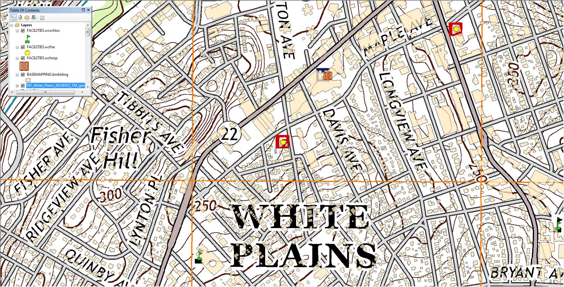
Georeferenced 2013 US Topo White Plains quadrangle.  While selected structures such as schools, fire houses and hospitals are identified on  default US Topo product, this image shows all Westchester County building footprints

Georeferenced 2013 US Topo White Plains quadrangle. While selected structures such as schools, fire houses and hospitals are identified on the default US Topo product, this image shows also shows how local content such as Westchester County building footprints can be made available to the NSDI structures data theme.

Unless a methodical and accepted process – adopted by pertinent local/state/federal stakeholders – is institutionalized  by the FGDC, the Geospatial Data Act of 2015 will continue to be more about federal and state geospatial programs and less about truly integrating and taking advantage of the vast amount of local government data.   The Act needs to specify and fund building work flows which communicate directly with the source of the data as well as working towards reducing the reliance on state “middle men” GIS programs as means to acquire local geospatial data. (Local governments were not even mentioned in a February 2015 General Accounting Office report entitled “GEOSPATIAL DATA: Progress Needed on Identifying Expenditures, Building and Utilizing a Data Infrastructure, and Reducing Duplicative Effort”.  A report which appears to be eerily similar and a rebaked version of the  (ill-fated) 2013 “Map It Once, Use It Many Times”   federal geospatial legislation attempting to reposition the federal effort to coordinate National geospatial data development.

Ironically, just one month prior to the Geospatial Data Act of 2015 being introduced, a scathing report was released by the Consortium of Geospatial Organizations (COGO) entitled “Report Card on the U.S. National Spatial Data Infrastructure”.  In short an overall “C-“ to NSDI effort over the past two decades.  The report falls short in not holding state GIS programs more accountable and responsible as well as most have  jockeyed over the past two decades to be seen as enablers and partners of the NSDI  effort in context of framework layer stewards, recipients of FGDC grants, and establishing/maintaining NSDI Clearinghouse nodes.  States supposedly as “middle men” and conduits to valuable local government geospatial data assets.   Perhaps COGO report cards on individual State government GIS programs are forthcoming.

At the end of the day, NSDI supporters actually do have access to a wide range of local government geospatial assets as files, consumable web services, or perhaps through some other middleware provided by a software vendor.   Or a combination of all the above.  The data and the technology are here.  To the end of furthering the intent of the NSDI, legislation like the Geospatial Act of 2015 will fall on deaf ears and not advance as it should unless the federal government establishes the means to directly engage and connect to local governments.


Opening the GIS Data Vault

The geospatial “open government” effort received a significant boost recently when the State of California Supreme Court ruled Orange County must grant access to its electronic mapping data without charging a licensing fee. The case was brought by the Sierra Club seeking access to mapping data in its fight to protect public land.  The case started in 2007, when the Sierra Club requested from Orange County a copy of its GIS parcel database, containing the location and layout of each legal parcel of land in the county. At that time, Orange County licensed copies of the parcel database to private companies and public agencies for $375,000. The county also required licensees to sign non-disclosure agreements preventing further distribution.  The California ruling augments one closer to home when in 2005 the Connecticut Supreme Court ruled in a similar case involving – and against – the Town of Greenwich.  There are several other relevant GIS legal challenges in the states of Florida, Wisconsin, South Carolina, and here in New York (Suffolk County copyright on tax maps) which are summarized in an excellent   2012 State of Indiana GIS Conference presentation entitled “Legalities of GIS” (Sparks and Estes).

Also in July 2013, whether mere coincidence or bowing to years of pressure and in response to the California ruling, New York City’s Department of City Planning quit charging fees for one of the most-demanded city datasets: PLUTO.  PLUTO (Primary Land Use Tax Lot Output) contains detailed information about every piece of land in the city (http://www.nyc.gov/html/dcp/html/bytes/dwn_pluto_mappluto.shtml) including tax assessments, historic districts, year built, number of units, lot size, etc. Before doing so, users had to pay $1,500 ($300 per borough) for the first time and then again for every update.  Not only did urban research institutes, community groups, nonprofits and planning firms have to pay the city each year for access to the data, but also had to stay compliant with a 14-page license agreement that, among other things, forbid them from sharing the data or putting any part of it on the internet.

So what?  What does the California ruling and release of the NYC PLUTO data really mean to the broader New York State GIS community?  In the short term, probably little. However,  it does seem the time is nearing when various New York statewide GIS organizations can come together to discuss, and perhaps, set in motion an effort to challenge the practice of charging fees and/or licensing tax-payer funded GIS data.  And at the center of this discussion would inevitably be New York’s Freedom of Information Law (FOIL).  Granted the long procedure of litigation, appeals, etc., is costly requiring deep pockets for even those who have the financial resources and legal support to endure the lengthy process but there are potentially dozens of organizations – environmental, not-for-profits, business interests, even governments – which have been confronted with the GIS data fee/licensing issue and have an interest in the issue.

Also, any serious statewide discussion on removing barriers towards selling and licensing geospatial data will first have to include a major review, revision, or complete elimination of the 16-year old NYS GIS Data Sharing Cooperative, which by extension, administers Cooperative Data Sharing Agreements for governments and not-for-profits.  The agreement itself may conflict with the basic tenets of “open government” in that the agreement currently excludes industry and business as Cooperative members as well as including provisions which allow Cooperative members to sell or license their own data.
And as if the growing body of legal decisions mandating governments to make GIS data available for free (beyond the reasonable cost of reproduction) is not enough, there is also a plethora of examples documenting the financial benefits for making geospatial data available at no cost. Note the NYC BigApps 3.0 competition which challenges software developers to create apps that use city data to “make NYC better”.  The 3.0 competition included $50,000 prize money.  Similar efforts are underway in other metropolitan areas of the country including Portland, Oregon.   There is also the new Open New York data portal albeit how well the Socrata-based system integrates with the existing statewide GIS data infrastructure is to be seen.    A very timely and outstanding read on the benefits of making public GIS data open and free was recently published (April 2013) by MetroGIS (Minneapolis/St. Paul). The report contains a myriad of rational and financial justification on making GIS data available for free – including a multi-county breakdown illustrating on how little money is actually made by individual counties after factoring in the COSTS of administering their GIS sales/licensing programs.    Further reading can found in a similar 2011 National States Geographic Information Council (NSGIC) publication entitled “Geospatial Data Sharing:  Guidelines for Best Practices”.

In the long run, the charging of fees and licensing for tax payer funded geospatial data will ultimately be recognized as neither sustainable or cost effective.  Personnel and organizations will change as government programs are reduced, and to survive, must become more public and business friendly.  Organizations will simply not have the personnel and/or rational to administer data sharing and licensing agreements developed 10-20 years ago. Finally, although there will always be a few exceptions, the belief that the selling or licensing of data somehow supports operational elements of public GIS programs, or is a large money maker, will finally be proven otherwise.

However, to wait for the issue – or problem – to simply take care of itself and ultimately fade away is not the most prudent course of action.  As we can reasonably expect the continued high demand for government GIS datasets to continue, combined with the growing body of judicial cases and “open government” initiatives supporting unrestricted access, the time has come for the discussion, and action, to be taken seriously here in New York State.

Not-for-Profits Gone Spatial

Leveraging web-based technology to reach wider audiences, combined with fewer tax-payer funded GIS initiatives, and improved “open government” data portals has led to a growing body of geospatial work by the Not-for-Profit (NFP) sector within New York State.  Ranging from basic community based mapping programs to scholarly research efforts, these statewide contributions come from national based organizations, land trusts, conservation districts, and a range of local environmental groups.

Several active programs, which are typical of statewide NFP GIS efforts, are located in the lower Hudson River Valley.  The Westchester Land Trust is similar to other statewide land trusts using GIS technology to support business and advocacy programs.  Working closely with the Westchester County GIS program WLT utilizes GIS to inventory and map individual properties, supports local environmental groups GIS/mapping efforts, and to promote events such GIS Day.

The Saw Mill River Coalition also uses GIS datasets in conducting land use studies and mapping projects.  Many local governments have open space committees which use GIS to inventory open spaces (local, county, state parks, cemeteries, schools, gardens, etc.) and are now using GIS tools to identify linkages and corridors such as right-of-ways and easements to connect open spaces.   Digital tax maps, public infrastructure, and utility system networks are useful sources of information in identifying such corridors.

Nearby is Hudsonia, a not-for-profit environmental institute which focuses on environmental research, education, training and technical assistance throughout the Hudson River Valley.  GIS-based habitat mapping is one of its signature geospatial programs and is used by local municipalities.   The New York/New Jersey Trail Conference provides workshops and uses GPS and GIS, a portion of which is based on user collected X,Y (trail) data for hardcopy map production on hiking trails throughout southeastern New York/Northern New Jersey.

More detailed GIS analysis by a NFP includes ongoing work at Mohonk Preserve outside of New Paltz, New York where managers and scientists are using GIS to map the relationship between rare species and their habitat as well as describing the importance and changes in ecological communities.   Much of the geospatial work at Mohonk was detailed in the Winter 2011/2012 issue of ArcNews.  GIS support services are also provided and offered through the Cornell Cooperative Extension Dutchess County (CCEDC).

One of the largest NFP GIS mapping programs in the state is the OASIS  (Open Accessible Space Information System) program covering the metropolitan New York City area and located at the CUNY Mapping Service at the Center for Urban Research.  Its mission is to “help nonprofits, community groups, educators, students, public agencies, and local businesses develop a better understanding of their environment with interactive maps of open spaces, property information, transportation networks, and more.”   The OASIS project has gone beyond its original New York City geographic footprint and is now involved in similar mapping efforts beyond the metropolitan region.  Their homepage has an extensive listing of other NFP programs, which contribute, to the OASIS initiative in context of providing data and/or funding.

On a statewide level, illustrative NFP GIS programs include:

Scenic Hudson:  Developed in concert with both government and academia, Scenic Hudson developed the online Sea Level Rise Mapper (SLR) application which is intended to “create visualizations of future scenarios of sea level rise.”   With the maps created as part of the application, Scenic Hudson is supporting communities’ efforts to develop adaptation plan.  Data and mapping products integrated into the application are a combination of results from new analyses by Scenic Hudson and existing data from a variety of sources including NYS DEC, US EPA, US Census Bureau, Dr. Roger Flood (SUNY Stony Brook) and FEMA.

FracTracker: This non-profit organization is dedicated to enhancing the public’s understanding of the impacts of the oil and gas industry by collecting, interpreting, and sharing data. With the Marcellus and Utica Shales at the focus of this environmental issue, FracTracker employs in-house GIS technology capacity to distribute maps (PDF format) and data, as well as using ArcGIS.com for interactive mapping. “Maps are central to our grassroots outreach effort, helping us communicate the relevant environmental issues associated with important statewide issue” says Karen Edelstein, New York State FracTracker liaison.

The Nature Conservancy:   In conjunction with the New York Natural Heritage Program and funded though the Hudson River Estuary Program,   TNC conducted a project that combined a GIS prioritization framework with field assessment methods to identify and prioritize culverts and dams that are of biological importance in the Hudson River Estuary (HRE).  The goal of this project was to identify a suite of barriers whose removal would provide a meaningful biological benefit in the HRE.   In all, over 13,000 potential barriers were identified in the study.

The NFPs referenced in this post represent only a small portion of similar statewide organizations that contribute significantly to a wide range of applications, data, personnel, funding, and underlying geospatial infrastructure across the state.  As a side note, the recent release of the New York Protected Areas Database (NYPAD) illustrates yet another scenario as to how government agencies can partner with and use the NFP structure, and in this case academia, to further strategic GIS programs.  Similar initiatives are funded through the New York Natural Heritage Programs (NYNHP).  Given today’s government financial climate, such an initiative would be very difficult to complete and maintain solely with public agency resources.

While historically the primary role of NFPs in the geospatial arena has been as a consumer of taxpayer funded GIS data, their role is quietly changing to that of a producer.   Long term, improvements in quantifying their economic and scientific contribution to the statewide geospatial effort warrants continued recognition and discussion.

Schools & GIS

Over the past several years much discussion linking GIS technology to the educational community  (i.e., K-12, middle and high school, Community Colleges, and universities) has focused mainly on integrating GIS concepts into the classroom environment.  While industry leaders such as ESRI and Google have contributed significantly and helped advance this effort, there exist several other pertinent program areas in school systems which on many levels overlap and can benefit by integrating with traditional, or “nearby” government GIS programs.  Ironically, the rational for the government/school GIS collaboration – if not justification – is that school based geospatial-based programs are often competing for the same tax dollar, in the same municipality or county, traditional GIS programs are feverishly trying to secure.  Illustrative common areas include:

Transportation Systems:  For the unknowing, local school district transportation budgets can often be eye-popping totaling into the hundred thousands, if not millions of dollars.  Illustratively, a  quick survey of online school district budgets in Westchester County, New York found several transportation budgets in excess of $3 million, others in the neighborhood of $6 million, and one as high as $9 million.    (Comparatively, similar budgets will vary greatly across the state depending geographic size and location of  district).  While much of the transportation budget money is for buses, maintenance, personnel, fuel, and other assets, many New York State school districts are actively utilizing GIS-based software for routing, scheduling, and leveraging GPS technology to track and locate buses for both fixed route and Paratransit systems.   Geocoding, address verification, and even the need for the production of hardcopy maps are also common in most school transportation offices.  One of the more popular bus transportation software packages in the state is Transfinder which has a broad statewide school district client base and access to updated address databases through the NYS Data Sharing Cooperative (via their client, school districts, as members of the Cooperative).  Another Albany based company engaged in student/bus transportation systems is Versatrans (Tyler Technologies).   Interestingly, as of July 2013, approximately half (nearly 45%) of the 535 listed members in state data sharing cooperative local government category are school districts.

Demographic Analysis/Statistics:  Census data, population statistics, live birth figures, and similar datasets have long been a staple of government GIS programs to map and distribute. It is these same datasets school districts often use in concert with a plethora of planning and engineering consultants, to support a wide range of administrative, facility planning,  capital improvement, and long range strategic plans.  GIS software provides a powerful analytical tool in visualizing demographic-based datasets with other relevant district wide features such as public transportation systems, traffic patterns, critical infrastructure, parks/athletic complexes, location of educational service providers, and district ADA compliant buildings.  Local tax parcel boundary data, building footprints, and related assessment data,  which are in the stewardship of local government GIS programs, add a further level of analysis and visualization.   All combined – with the input and support of local GIS programs, GIS “mash-ups” can be created and made available to school district staff, school boards, and other community groups involved in school district programs.  Similarly, Westchester County GIS online mapping applications are used by the City of Mt. Vernon school district for address and residency verification.  Also, GIS software is increasingly being used to redistrict school district boundaries and individual school catchment areas.

Facilities Management/Safe Schools:  While many readily available software products such as Google Maps, Bing Maps, ArcGIS.com, and even Yahoo! Maps offer aerial views of school facilities and campuses, this imagery is routinely “leaf-on” and therefore can have important ground features covered or obscured.  Local government GIS programs are uniquely positioned to collaborate with schools in offering more detailed and higher resolution “leaf-off” imagery used in local base mapping projects.  Similar opportunities exist for local governments to collaborate with universities and colleges which are using GIS as a framework to support comprehensive facilities management plans.  Three  illustrative efforts in this regard are the  University of Rochester,  SUNY Albany and SUNY Cortland – each providing a basis for neighboring communities or organizations to cost-share in geospatial products such as orthophotography, LiDAR, or planimetric mapping, all of which are used in compiling campus facility base maps.  GIS data and mapping is also used in the development of school security plans.  Recent incidents at public schools and on college campuses have led to both federal and New York State initiatives which increase the opportunity for the GIS community to work with school administrators and local law enforcement agencies in developing security plans and related mapping products.

Many opportunities currently exist for GIS professionals to reach out to the educational community and identify joint geospatial programs and applications.  Building such strategic alliances with schools is budget wise and can result in the valuable cost sharing of applications, coordinating procurement of similar products such as aerial photography and planimetric features (building footprints, visible infrastructure features, topography, hydrology), or the effective design of common hardware and software infrastructure.  Looking forward, such proactive efforts on the part of the New York State GIS community will help nurture and build an important statewide partner and user constituency.

Multi-Government GIS

Over the past 25 years the success of the Westchester County GIS program can be attributed to several key factors that include ongoing administrative and political support, a common technology vision over many years of management leaders, as well as continuous years of superior GIS staff and technical support.  However, one of the most important and enduring elements has been the collaborative work between multiple governments – specifically between Westchester County and its 43 municipalities.

Early on and even before web technology and services had matured to what is available today, local governments, not-for-profits, and community groups realized cost efficiencies in utilizing Westchester County GIS products and services in helping build geospatial capacity within their organizations. While expansion of the County’s GIS infrastructure was slow and at times limited due to early desktop GIS client software, expansion and deployment has changed dramatically in the last 18-36 months with the increased availability of easy-to-use web viewers, access to data-rich map services, and local GIS datasets.

Westchester County is not the only current multi-agency or regional government GIS effort in the state.  One of the best and more visible examples of cost effective geospatial shared services is the Erie County GIS program which continues to provide a framework for providing and developing GIS capabilities for both Erie and Niagara Counties as well as selected neighboring towns.

Other illustrative and successful multi-agency/regional GIS programs include the Southern Tier Western Regional Planning & Development Board “Community GIS” serving Chautauqua, Cattaraugus & Allegheny Counties and the Seneca Nation of Indians. In northern New York State, encouraging efforts are being made by the Development Authority of the North Country towards building and expanding geospatial capacity for the villages of Heuvelton and Clayton, the Town of Clayton and Jefferson County.  Other illustrative statewide multi-government GIS programs include both the Dutchess County GIS program and the Tompkins County – City of Ithaca Interactive Maps collaboration.  These and other selected initiatives across the state have built multi-government GIS business plans with support from the New York State Local Government Efficiency Program (LGe) which provides funding for the development of projects that will achieve savings and improve municipal efficiency through shared services and cooperative agreements.

As government downsizing continues, opportunities to expand and build GIS capacity in local governments across New York State will often be most feasible and practical in a multi-government or regional framework where financial, technical and administrative support can be consolidated. Such initiatives will support similar business needs as well as common organizational and business requirements.

“Cloud” concepts now resonate and are understood, if not embraced, among elected officials and managers across governments.   The GIS infrastructure is now in place so that multiple governments can have data housed in one location, accessing web services from other government agencies, combining local content – all at the same time while using one of several free viewing clients such as ArcGIS Explorer, Gaia 3.0, and Google Earth 7).  Such “mash-up” configurations dramatically decrease the time building GIS data access and viewing capabilities.  While such viewers come with limited spatial analysis capabilities, there is nonetheless a significant reduction in hardware and software investments – which is often a major GIS implementation obstacle for small to mid-range sized governments and organizations across the state.

Geospatial technology has evolved such that there is a very limited or viable business case for every governmental organization to fund and support it’s own GIS program.  Shared Services is no longer a “nice to have” but rather the new government reality.  The New York State geospatial community will do well to embrace and promote this new paradigm towards building multi-government and cost-effective GIS programs.

Getting Started

eSpatially New York  focuses on geospatial technology development, current issues, and the broad range of geospatial users across the State of New York.  Illustrative issues to be highlighted include government programs, emerging technologies, business and industry leaders, and the use of geospatial applications in smaller markets such as schools and community based programs.